Jockey's Wood

Wood, Forest in Sussex Wealden

England

Jockey's Wood

Access road to Buckhurst Park This track/road leads from Withyham to a large estate building.
The track is also used by the High Weald Landscape Trail heading towards Lye Green.
Access road to Buckhurst Park Credit: David Anstiss

Jockey's Wood is a picturesque woodland located in Sussex, England. Covering an area of approximately 20 acres, it is situated near the town of Horsham and is easily accessible to visitors. The woodland is known for its diverse range of tree species, including oak, ash, beech, and birch, which create a vibrant and lush environment throughout the year.

The woodland is a popular destination for nature enthusiasts, hikers, and families seeking a peaceful and tranquil experience amidst nature. It offers numerous walking trails that wind through the trees, providing visitors with an opportunity to explore its beauty at their own pace. These paths are well-maintained and clearly marked, ensuring a safe and enjoyable experience for all.

Jockey's Wood is home to a rich variety of wildlife, making it a haven for nature lovers and birdwatchers. Visitors may encounter species such as woodpeckers, owls, deer, and squirrels as they explore the woodland. The peaceful atmosphere and abundance of wildlife create a perfect setting for photography and nature observation.

The woodland is managed by a local conservation group that ensures its preservation and protection. They organize regular events and activities, such as guided walks and educational programs, to promote awareness and appreciation of the natural environment. The group also works to maintain the woodland's biodiversity through careful management practices.

Overall, Jockey's Wood is a beautiful and well-preserved woodland that offers a serene escape from the hustle and bustle of everyday life. Its scenic trails, diverse wildlife, and commitment to conservation make it a must-visit destination for anyone seeking a connection with nature in Sussex.

If you have any feedback on the listing, please let us know in the comments section below.

Jockey's Wood Images

Images are sourced within 2km of 51.092217/0.16544034 or Grid Reference TQ5134. Thanks to Geograph Open Source API. All images are credited.

Access road to Buckhurst Park This track/road leads from Withyham to a large estate building.
The track is also used by the High Weald Landscape Trail heading towards Lye Green.
Access road to Buckhurst Park
This track/road leads from Withyham to a large estate building. The track is also used by the High Weald Landscape Trail heading towards Lye Green.
Bridge on Buckhurst Park access road This bridge passes over a tributary of the River Medway (heading from St Johns, near Crowborough to the Medway near Balls Green).

The bridge is also used by the High Weald Landscape Trail heading to Lye Green.
Bridge on Buckhurst Park access road
This bridge passes over a tributary of the River Medway (heading from St Johns, near Crowborough to the Medway near Balls Green). The bridge is also used by the High Weald Landscape Trail heading to Lye Green.
River Medway Tributary As seen from <a href="https://www.geograph.org.uk/photo/3512674">TQ4935 : Bridge on Buckhurst Park access road</a>.

Looking upstream.
River Medway Tributary
As seen from TQ4935 : Bridge on Buckhurst Park access road. Looking upstream.
Chalybeate Spring Wellhouse, Buckhurst Park This Grade II listed building is over one of the mineral rich springs of Tunbridge Wells. 

See <span class="nowrap"><a title="http://www.britishlistedbuildings.co.uk/en-296879-the-wellhouse-over-the-chalybeate-spring" rel="nofollow ugc noopener" href="http://www.britishlistedbuildings.co.uk/en-296879-the-wellhouse-over-the-chalybeate-spring">Link</a><img style="margin-left:2px;" alt="External link" title="External link - shift click to open in new window" src="https://s1.geograph.org.uk/img/external.png" width="10" height="10"/></span> for more details about the wellhouse.

In the background (on the woodland edge) is one of the tributaries of River Medway.
Chalybeate Spring Wellhouse, Buckhurst Park
This Grade II listed building is over one of the mineral rich springs of Tunbridge Wells. See LinkExternal link for more details about the wellhouse. In the background (on the woodland edge) is one of the tributaries of River Medway.
Saunders, Buckhurst Park A Grade II listed peg-tiled cottage.

See <span class="nowrap"><a title="http://www.britishlistedbuildings.co.uk/en-296880-saunders-withyham-east-sussex" rel="nofollow ugc noopener" href="http://www.britishlistedbuildings.co.uk/en-296880-saunders-withyham-east-sussex">Link</a><img style="margin-left:2px;" alt="External link" title="External link - shift click to open in new window" src="https://s1.geograph.org.uk/img/external.png" width="10" height="10"/></span> for more details about the building.
Saunders, Buckhurst Park
A Grade II listed peg-tiled cottage. See LinkExternal link for more details about the building.
The Old Mill House, Buckhurst Park A Grade II listed building within the estate of Buckhurst Park.

It is beside a tributary of the River Medway.

See <span class="nowrap"><a title="http://www.britishlistedbuildings.co.uk/en-296881-the-old-mill-house-withyham-east-sussex" rel="nofollow ugc noopener" href="http://www.britishlistedbuildings.co.uk/en-296881-the-old-mill-house-withyham-east-sussex">Link</a><img style="margin-left:2px;" alt="External link" title="External link - shift click to open in new window" src="https://s1.geograph.org.uk/img/external.png" width="10" height="10"/></span> for more details about the building.
The Old Mill House, Buckhurst Park
A Grade II listed building within the estate of Buckhurst Park. It is beside a tributary of the River Medway. See LinkExternal link for more details about the building.
House and old well on the High Weald Landscape Trail This view is from the High Weald Landscape Trail, just below the impressive house of Buckhurst Park. It is on the Buckhurst Estate.

For more information about this section of the High Weald Landscape Trail see <span class="nowrap"><a title="http://www.highweald.org/downloads/publications/exploring-the-high-weald/high-weald-landscape-trail/974-chapter-3-east-grinstead-to-groombridge/file.html" rel="nofollow ugc noopener" href="http://www.highweald.org/downloads/publications/exploring-the-high-weald/high-weald-landscape-trail/974-chapter-3-east-grinstead-to-groombridge/file.html">Link</a><img style="margin-left:2px;" alt="External link" title="External link - shift click to open in new window" src="https://s1.geograph.org.uk/img/external.png" width="10" height="10"/></span>
House and old well on the High Weald Landscape Trail
This view is from the High Weald Landscape Trail, just below the impressive house of Buckhurst Park. It is on the Buckhurst Estate. For more information about this section of the High Weald Landscape Trail see LinkExternal link
The Old Mill House Mousehold Mill occupied the site on the 1597 Buckhurst Terrier with the current building appearing to date from the 17th century and later called Withyham Mill.
The Old Mill House
Mousehold Mill occupied the site on the 1597 Buckhurst Terrier with the current building appearing to date from the 17th century and later called Withyham Mill.
Saunders Weatherboarded cottage located in the Buckhurst Park estate dating from the 17th century.
Saunders
Weatherboarded cottage located in the Buckhurst Park estate dating from the 17th century.
King's Standing Gill A tributary of the River Medway that rises near King Standing in the Ashdown Forest. I have also seen the watercourse referred to as Warren Brook. This straight section was most likely excavated for use either at the nearby Withyham Mill to the west or the former Withyham Forge to the east.
King's Standing Gill
A tributary of the River Medway that rises near King Standing in the Ashdown Forest. I have also seen the watercourse referred to as Warren Brook. This straight section was most likely excavated for use either at the nearby Withyham Mill to the west or the former Withyham Forge to the east.
Orchard Mead The name of the field according to Withyham's 1842 tithe map bounded by King's Standing Gill to the south and east. Now merged with <a href="https://www.geograph.org.uk/photo/6950401">TQ4935 : Withyham Cricket Field</a> to the west to form a sports ground. The wood beyond is The Warren.
Orchard Mead
The name of the field according to Withyham's 1842 tithe map bounded by King's Standing Gill to the south and east. Now merged with TQ4935 : Withyham Cricket Field to the west to form a sports ground. The wood beyond is The Warren.
Withyham Cricket Field Originally known as Fair Field according to Withyham's 1842 tithe map, perhaps an indicator of former social activities that occurred here in the past.
Withyham Cricket Field
Originally known as Fair Field according to Withyham's 1842 tithe map, perhaps an indicator of former social activities that occurred here in the past.
Saunders, Buckhurst Park Grade II listed.
Saunders, Buckhurst Park
Grade II listed.
The Old Mill House Grade II listed.
The Old Mill House
Grade II listed.
Saunders, Buckhurst Park Grade II listed.
Saunders, Buckhurst Park
Grade II listed.
Chalybeate Spring Wellhouse, Buckhurst Park Listed buildings and structures are officially designated as being of special architectural, historical or cultural significance. There are over half a million listed structures in the United Kingdom, covered by around 375,000 listings.
Listed status is more commonly associated with buildings or groups of buildings, however it can cover many other structures, including bridges, headstones, steps, ponds, monuments, walls, phone boxes, wrecks, parks, and heritage sites, and in more recent times a road crossing (Abbey Road) and graffiti art (Banksy 'Spy-booth') have been included.

In England and Wales there are three main listing designations;
Grade I (2.5%) - exceptional interest, sometimes considered to be internationally important.
Grade II* (5.5%) - particularly important buildings of more than special interest. 
Grade II (92%) - nationally important and of special interest. 

There are also locally listed structures (at the discretion of local authorities) using A, B and C designations.

In Scotland three classifications are also used but the criteria are different. There are around 47,500 Listed buildings.
Category A (8%)- generally equivalent to Grade I and II* in England and Wales
Category B (51%)- this appears generally to cover the ground of Grade II, recognising national importance.
Category C (41%)- buildings of local importance, probably with some overlap with English Grade II.

In Northern Ireland the criteria are similar to Scotland, but the classifications are:
Grade A (2.3%)
Grade B+ (4.7%)
Grade B (93%)

Read more at Wikipedia <span class="nowrap"><a title="http://en.wikipedia.org/wiki/Listed_building" rel="nofollow ugc noopener" href="http://en.wikipedia.org/wiki/Listed_building">Link</a><img style="margin-left:2px;" alt="External link" title="External link - shift click to open in new window" src="https://s1.geograph.org.uk/img/external.png" width="10" height="10"/></span>
Chalybeate Spring Wellhouse, Buckhurst Park
Listed buildings and structures are officially designated as being of special architectural, historical or cultural significance. There are over half a million listed structures in the United Kingdom, covered by around 375,000 listings. Listed status is more commonly associated with buildings or groups of buildings, however it can cover many other structures, including bridges, headstones, steps, ponds, monuments, walls, phone boxes, wrecks, parks, and heritage sites, and in more recent times a road crossing (Abbey Road) and graffiti art (Banksy 'Spy-booth') have been included. In England and Wales there are three main listing designations; Grade I (2.5%) - exceptional interest, sometimes considered to be internationally important. Grade II* (5.5%) - particularly important buildings of more than special interest. Grade II (92%) - nationally important and of special interest. There are also locally listed structures (at the discretion of local authorities) using A, B and C designations. In Scotland three classifications are also used but the criteria are different. There are around 47,500 Listed buildings. Category A (8%)- generally equivalent to Grade I and II* in England and Wales Category B (51%)- this appears generally to cover the ground of Grade II, recognising national importance. Category C (41%)- buildings of local importance, probably with some overlap with English Grade II. In Northern Ireland the criteria are similar to Scotland, but the classifications are: Grade A (2.3%) Grade B+ (4.7%) Grade B (93%) Read more at Wikipedia LinkExternal link
Stream in Buckhurst Park
HWLT, Buckhurst Park The High Weald Landscape Trail (HWLT) is a 90 mile route between Horsham, West Sussex and Rye, East Sussex, designed to pass through the main landscape types of the High Weald Area of Outstanding Natural Beauty (AONB). It does not follow the highest ground, and the eastern section is only a few feet above sea level. It keeps to the northern edge of the High Weald except in the west where it runs close to the southern edge for a short distance.
It is a trail of regional importance supported by the High Weald Forum and local authorities in East and West Sussex, and Kent. The route is well signposted. It follows public rights of way and roads with the occasional permissive path.
The geology is alternating sandstones and clays, and the latter can be very muddy in wet conditions so boots are a must except in very dry weather. Some sections become very overgrown in summer with nettles and brambles.
HWLT, Buckhurst Park
The High Weald Landscape Trail (HWLT) is a 90 mile route between Horsham, West Sussex and Rye, East Sussex, designed to pass through the main landscape types of the High Weald Area of Outstanding Natural Beauty (AONB). It does not follow the highest ground, and the eastern section is only a few feet above sea level. It keeps to the northern edge of the High Weald except in the west where it runs close to the southern edge for a short distance. It is a trail of regional importance supported by the High Weald Forum and local authorities in East and West Sussex, and Kent. The route is well signposted. It follows public rights of way and roads with the occasional permissive path. The geology is alternating sandstones and clays, and the latter can be very muddy in wet conditions so boots are a must except in very dry weather. Some sections become very overgrown in summer with nettles and brambles.
Show me another place!

Jockey's Wood is located at Grid Ref: TQ5134 (Lat: 51.092217, Lng: 0.16544034)

Administrative County: East Sussex

District: Wealden

Police Authority: Sussex

What 3 Words

///consonant.dignity.ballooned. Near Groombridge, East Sussex

Related Wikis

Penn's Rocks

Penn's Rocks is a 10.2-hectare (25-acre) biological Site of Special Scientific Interest north of Crowborough in East Sussex.This site is a steep sided...
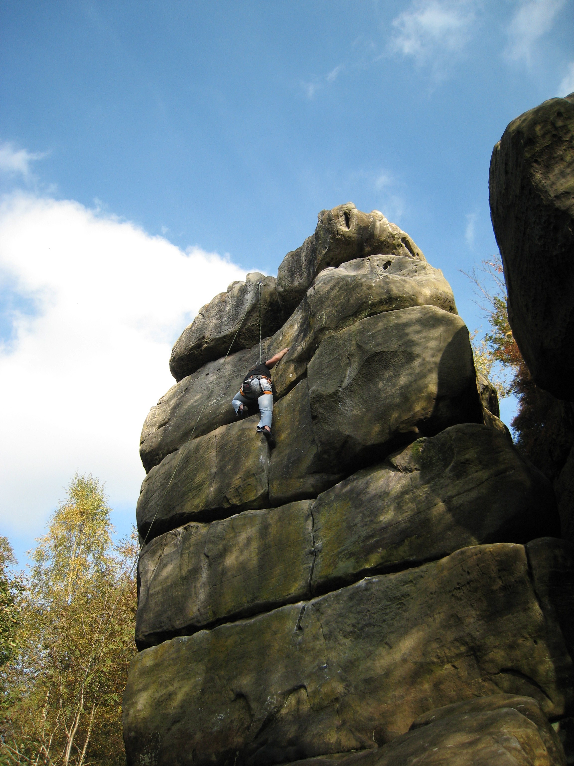
Harrison's Rocks

Harrison's Rocks is a series of sandstone crags approximately 1.5 kilometres (1 mi) south of the village of Groombridge in the county of East Sussex. The...

Buckhurst Park, East Sussex

Buckhurst Park is an English country house and landscaped park in Withyham, East Sussex. It is the seat of William Sackville, 11th Earl De La Warr.The...

Bream Wood

Bream Wood is a 7.8-hectare (19-acre) biological Site of Special Scientific Interest north of Crowborough in East Sussex.This steep sided valley wood has...

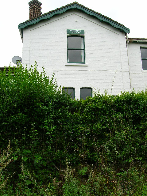
Withyham railway station

Withyham was a railway station on the Three Bridges to Tunbridge Wells Central Line which closed in 1967, a casualty of the Beeching Axe. The station opened...

Oliver Sutton (RAF officer)

Captain Oliver Manners Sutton (12 March 1896 – 16 August 1921) was a British First World War flying ace credited with seven aerial victories. == Family... ==

Withyham

Withyham is a village and large civil parish in the Wealden district of East Sussex, England. The village is situated 7 miles south west of Royal Tunbridge...

Eridge railway station

Eridge railway station is on the Uckfield branch of the Oxted line in southern England and serves a rural district around Eridge in East Sussex. It is...

Nearby Amenities

Located within 500m of 51.092217,0.16544034
Barrier: stile
Lat/Long: 51.0942557/0.1705615
Barrier: stile
Lat/Long: 51.0943093/0.1705129
Barrier: stile
Material: wood
Stile: stepover
Lat/Long: 51.0897557/0.1654205
Barrier: stile
Material: wood
Stile: stepover
Lat/Long: 51.0910534/0.166961
Barrier: stile
Material: wood
Stile: ladder
Lat/Long: 51.0949371/0.1698035
The data included in this document is from www.openstreetmap.org. The data is made available under ODbL.

Have you been to Jockey's Wood?

Leave your review of Jockey's Wood below (or comments, questions and feedback).