The Spinney

Wood, Forest in Cambridgeshire South Cambridgeshire

England

The Spinney

Whittlesford Road Leaving Newton.
Whittlesford Road Credit: Hugh Venables

The Spinney, located in Cambridgeshire, is a picturesque woodland area that offers a serene retreat from the bustling city life. Stretching across a vast expanse, this wood encompasses various species of trees, creating a diverse and rich forest ecosystem. The Spinney is known for its dense canopy, which provides a cool and shaded environment, perfect for nature enthusiasts and avid hikers.

The wood is home to a wide range of flora and fauna, including oak, beech, and ash trees that stand tall and majestic. These trees provide a haven for various bird species, such as woodpeckers and owls, which can often be spotted flitting between the branches. Additionally, the forest floor is adorned with an array of wildflowers, ferns, and mosses, creating a vibrant and colorful undergrowth.

Visitors to The Spinney can enjoy a network of well-maintained trails that wind through the woods, allowing for leisurely walks and exploration of the natural surroundings. The tranquil atmosphere and peaceful ambiance make it an ideal location for picnics, meditation, or simply a quiet escape from the noise of daily life.

The Spinney is a protected area, managed by local authorities to preserve its natural beauty and ecological importance. Conservation efforts are in place to ensure the sustainability of the woodland, making it a valuable resource for research and education. Whether visitors seek solace in nature, an opportunity to observe wildlife, or a chance to learn about the environment, The Spinney delivers an enriching experience for all.

If you have any feedback on the listing, please let us know in the comments section below.

The Spinney Images

Images are sourced within 2km of 52.136818/0.12230782 or Grid Reference TL4550. Thanks to Geograph Open Source API. All images are credited.

Whittlesford Road Leaving Newton.
Whittlesford Road
Leaving Newton.
Cottage on the edge of Newton
Cockle Close, Newton New housing on the edge of the village.
Cockle Close, Newton
New housing on the edge of the village.
Kidmans Close, Newton
Cycling to and from Newton Two cyclists, one with serious kit, the other with a camera, are about to pass on the bridleway which links Newton and Stapleford. It was a hot Sunday morning during the heatwave of autumn 2011.
Cycling to and from Newton
Two cyclists, one with serious kit, the other with a camera, are about to pass on the bridleway which links Newton and Stapleford. It was a hot Sunday morning during the heatwave of autumn 2011.
Sunday-morning traffic on the M11 Looking towards Cambridge from the bridge which carries the Newton-Stapleford bridleway.
Sunday-morning traffic on the M11
Looking towards Cambridge from the bridge which carries the Newton-Stapleford bridleway.
Bridle path and motorway bridge The bridge carries the Newton-Stapleford bridleway and was built with farm vehicles in mind. The sign gives early warning of Trumpington Park & Ride, near the next turn-off, Junction 11.
Bridle path and motorway bridge
The bridge carries the Newton-Stapleford bridleway and was built with farm vehicles in mind. The sign gives early warning of Trumpington Park & Ride, near the next turn-off, Junction 11.
Byway to Stapleford <a href="https://www.geograph.org.uk/photo/749805">TL4449 : Public Bridleway to the Shelfords</a> shows more or less the same view towards the M11 in Spring 2008, when South Cambridgeshire was rather greener than during the 2011 drought.
Byway to Stapleford
TL4449 : Public Bridleway to the Shelfords shows more or less the same view towards the M11 in Spring 2008, when South Cambridgeshire was rather greener than during the 2011 drought.
Cockle Hill Taken during the 2011 drought (and the September-October heatwave). Compare this picture with Duncan Grey's <a href="https://www.geograph.org.uk/photo/840222">TL4449 : Across the field to Cockle Hill</a> from June 2008.
Cockle Hill
Taken during the 2011 drought (and the September-October heatwave). Compare this picture with Duncan Grey's TL4449 : Across the field to Cockle Hill from June 2008.
Footpath to New Farm and Cambridge Road Taken during the 2011 drought (and the September-October heatwave). Compare this picture with Keith Edkins' <a href="https://www.geograph.org.uk/photo/749802">TL4449 : Public Footpath to New Farm Road</a>, taken in spring 2008.
Footpath to New Farm and Cambridge Road
Taken during the 2011 drought (and the September-October heatwave). Compare this picture with Keith Edkins' TL4449 : Public Footpath to New Farm Road, taken in spring 2008.
M11 northbound Ahead is a farm accommodation and public bridleway bridge.
M11 northbound
Ahead is a farm accommodation and public bridleway bridge.
Whittlesford Road
Whittlesford Road
Heading north - Whittlesford Road Just past Ley Grove cottages.
Heading north - Whittlesford Road
Just past Ley Grove cottages.
M11 tops a rise near Newton In general the motorway is pretty level in this area.
M11 tops a rise near Newton
In general the motorway is pretty level in this area.
Ley Grove Cottages, near Little Shelford Ley Grove Cottages is an row of cottages in the Cambridgeshire countryside near the village of  Little Shelford.

Long shadows indicate that this image was taken during the evening.
Ley Grove Cottages, near Little Shelford
Ley Grove Cottages is an row of cottages in the Cambridgeshire countryside near the village of Little Shelford. Long shadows indicate that this image was taken during the evening.
Ley Grove Cottages An isolated row on the road between Little Shelford and Whittlesford. As the clear sky to the north and west promised, it would be a sunny December day, but just before ten o'clock the sun had yet to break through cloud to the south and east.
Ley Grove Cottages
An isolated row on the road between Little Shelford and Whittlesford. As the clear sky to the north and west promised, it would be a sunny December day, but just before ten o'clock the sun had yet to break through cloud to the south and east.
Bridge over the M11 The M11 is a 50 mile motorway from the North Circular Road in London to the A14 near Cambridge. The motorway was completed in 1980.
Wikipedia: <span class="nowrap"><a title="http://en.wikipedia.org/wiki/M11_motorway" rel="nofollow ugc noopener" href="http://en.wikipedia.org/wiki/M11_motorway">Link</a><img style="margin-left:2px;" alt="External link" title="External link - shift click to open in new window" src="https://s1.geograph.org.uk/img/external.png" width="10" height="10"/></span>
Bridge over the M11
The M11 is a 50 mile motorway from the North Circular Road in London to the A14 near Cambridge. The motorway was completed in 1980. Wikipedia: LinkExternal link
M11, southbound The M11 is a 50 mile motorway from the North Circular Road in London to the A14 near Cambridge. The motorway was completed in 1980.
Wikipedia: <span class="nowrap"><a title="http://en.wikipedia.org/wiki/M11_motorway" rel="nofollow ugc noopener" href="http://en.wikipedia.org/wiki/M11_motorway">Link</a><img style="margin-left:2px;" alt="External link" title="External link - shift click to open in new window" src="https://s1.geograph.org.uk/img/external.png" width="10" height="10"/></span>
M11, southbound
The M11 is a 50 mile motorway from the North Circular Road in London to the A14 near Cambridge. The motorway was completed in 1980. Wikipedia: LinkExternal link
Show me another place!

The Spinney is located at Grid Ref: TL4550 (Lat: 52.136818, Lng: 0.12230782)

Administrative County: Cambridgeshire

District: South Cambridgeshire

Police Authority: Cambridgeshire

What 3 Words

///students.respected.wobbles. Near Harston, Cambridgeshire

Related Wikis

Little Shelford

Little Shelford is a village located to the south of Cambridge, in the county of Cambridgeshire, in eastern England. The River Granta lies between it...

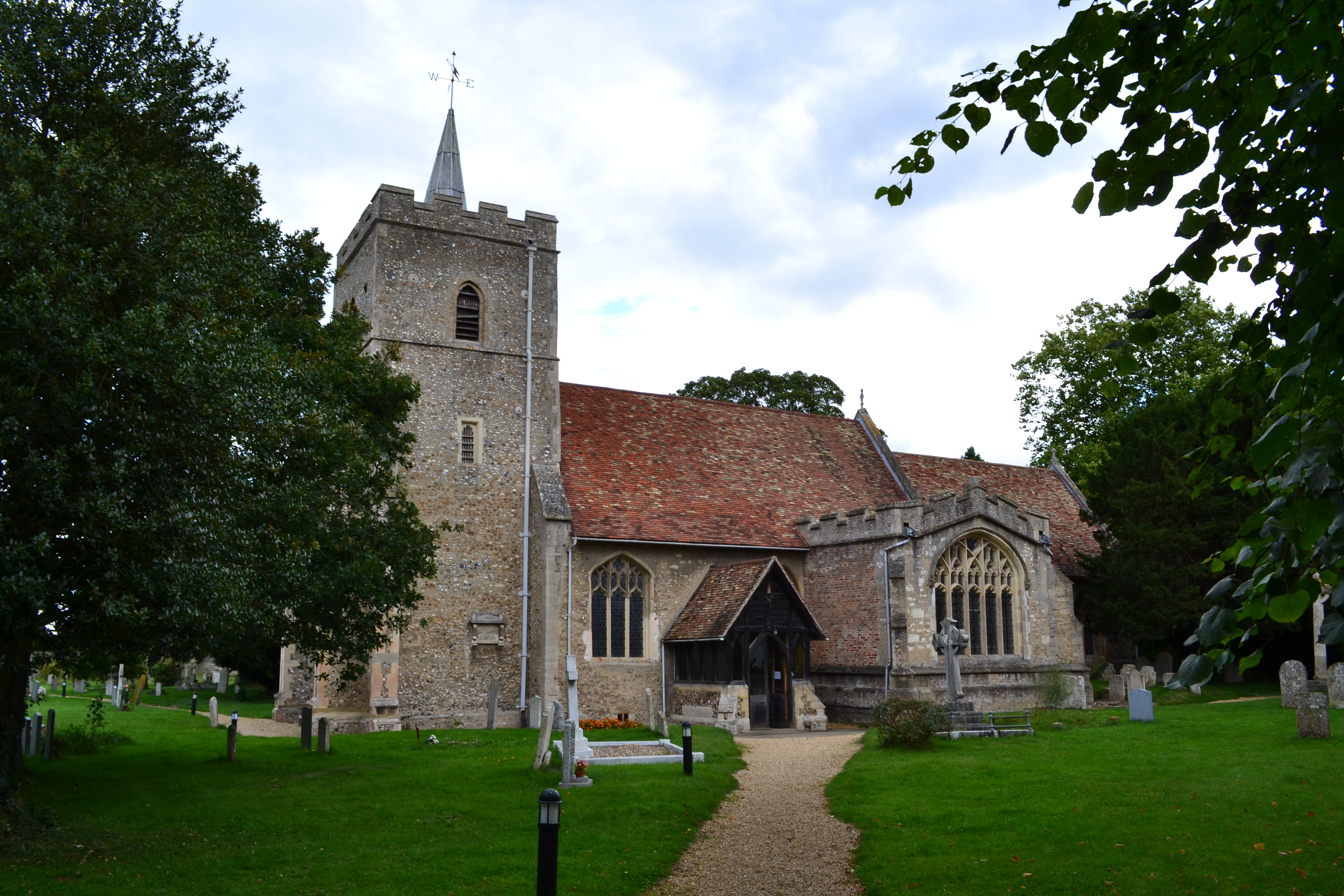
Church of All Saints, Little Shelford

The Church of All Saints is a Church of England parish church in Little Shelford, Cambridgeshire. The church is a Grade II* listed building, and dates...

Great Shelford F.C.

Great Shelford Football Club are a football club based in Great Shelford, near Cambridge, England. Established in 1912, they currently play in the Cambridgeshire...

South Cambridgeshire

South Cambridgeshire is a local government district of Cambridgeshire, England, with a population of 162,119 at the 2021 census. It was formed on 1 April...

Great Shelford

Great Shelford is a village located approximately 4 miles (6.4 km) to the south of Cambridge, in Cambridgeshire, in eastern England. In 1850 Great Shelford...

Shelford railway station

Shelford railway station is on the West Anglia Main Line serving the villages of Great Shelford, Little Shelford and Stapleford in Cambridgeshire, England...

Hauxton

Hauxton is a small village in Cambridgeshire, England around 5 miles to the south-west of Cambridge. == History == Hauxton has been occupied for well over...

Dernford Fen

Dernford Fen is a 10.3-hectare (25-acre) biological Site of Special Scientific Interest north-west of Sawston in Cambridgeshire.The site is a rare surviving...

Nearby Amenities

Located within 500m of 52.136818,0.12230782
Pub
The Navigator
Cuisine: thai
Food: yes
Phone: +44 1223 843901
Website: https://www.thenavigator-thai.co.uk/
Lat/Long: 52.1402923/0.1229162
Post Box
Brand: Royal Mail
Brand Wikidata: Q638098
Brand Wikipedia: en:Royal Mail
Collection Times: Mo-Fr 09:00; Sa 07:00
Operator: Royal Mail
Operator Wikidata: Q638098
Post Box Type: lamp
Ref: CB22 415D
Royal Cypher: EIIR
Royal Cypher Wikidata: Q33102113
Source: survey
Lat/Long: 52.1397846/0.1233572
Bus Stop
The Navigator
Naptan AtcoCode: 0500SLITS005
Naptan Bearing: SE
Naptan BusStopType: CUS
Naptan CommonName: The Navigator
Naptan Indicator: o/s
Naptan Landmark: High Street
Naptan NaptanCode: cmbgagwg
Naptan Street: High Street
Naptan Verified: no
Source: naptan_import
Lat/Long: 52.1403183/0.1228129
Bus Stop
The Navigator
Naptan AtcoCode: 0500SLITS012
Naptan Bearing: NW
Naptan CommonName: The Navigator
Naptan Indicator: opp
Naptan Landmark: High Street
Naptan NaptanCode: cmbgajaj
Naptan Street: High Street
Naptan Verified: no
Source: naptan_import
Lat/Long: 52.1402764/0.1227316
Power: pole
Lat/Long: 52.1395476/0.1280815
Bench
Backrest: yes
Inscription: IN REMEMBRANCE OF EDWARD LONGSDON JERWOOD 1947 AND CLARE HIS WIFE 1960
Material: wood
Openbenches Id: 22830
Lat/Long: 52.1402866/0.1227059
The data included in this document is from www.openstreetmap.org. The data is made available under ODbL.

Have you been to The Spinney?

Leave your review of The Spinney below (or comments, questions and feedback).