Great Southey Wood

Wood, Forest in Hertfordshire East Hertfordshire

England

Great Southey Wood

A10, southbound The A10 runs 161 miles from London to King's Lynn. via Cambridge and Ely. 
<span class="nowrap"><a title="http://www.sabre-roads.org.uk/wiki/index.php?title=A10" rel="nofollow ugc noopener" href="http://www.sabre-roads.org.uk/wiki/index.php?title=A10">Link</a><img style="margin-left:2px;" alt="External link" title="External link - shift click to open in new window" src="https://s1.geograph.org.uk/img/external.png" width="10" height="10"/></span>
A10, southbound Credit: N Chadwick

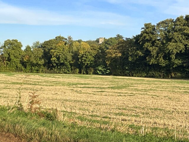
Great Southey Wood is a sprawling forest located in Hertfordshire, England. Covering an area of approximately 1,500 acres, it is a significant natural landmark in the region. The wood is predominantly made up of oak and beech trees, which create a dense canopy that provides shelter and habitat for a wide variety of wildlife.

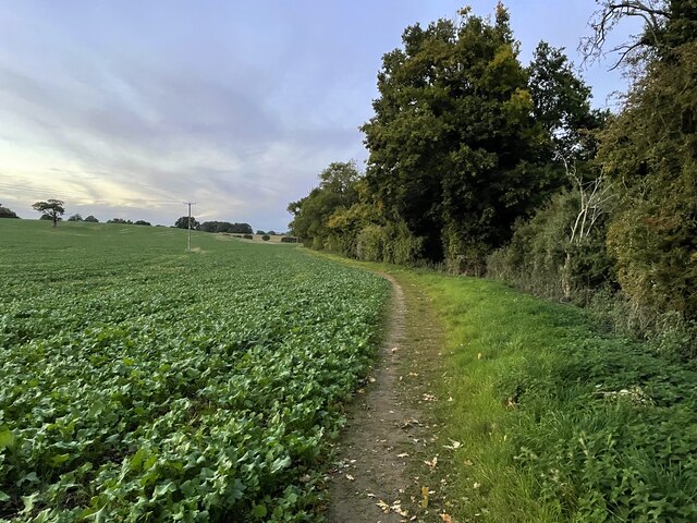
The woodland is crisscrossed with a network of winding footpaths and trails, making it a popular destination for nature lovers, hikers, and dog walkers. The paths meander through the forest, offering visitors a chance to immerse themselves in the tranquility of nature. The wood is particularly enchanting during the spring and summer months when the trees are in full bloom, and a colorful array of wildflowers carpet the forest floor.

Great Southey Wood is home to a diverse range of wildlife, including deer, foxes, badgers, and numerous bird species. Nature enthusiasts can spot woodpeckers, owls, and other woodland birds in the treetops, while the forest floor is home to an abundance of insects, reptiles, and small mammals.

Visitors to Great Southey Wood can enjoy a peaceful and serene environment, away from the hustle and bustle of city life. The forest provides an excellent opportunity for relaxation, birdwatching, photography, and simply appreciating the beauty of nature. It is a valuable natural resource that contributes to the conservation and preservation of Hertfordshire's biodiversity.

If you have any feedback on the listing, please let us know in the comments section below.

Great Southey Wood Images

Images are sourced within 2km of 51.848773/-0.009473723 or Grid Reference TL3718. Thanks to Geograph Open Source API. All images are credited.

A10, southbound The A10 runs 161 miles from London to King's Lynn. via Cambridge and Ely. 
<span class="nowrap"><a title="http://www.sabre-roads.org.uk/wiki/index.php?title=A10" rel="nofollow ugc noopener" href="http://www.sabre-roads.org.uk/wiki/index.php?title=A10">Link</a><img style="margin-left:2px;" alt="External link" title="External link - shift click to open in new window" src="https://s1.geograph.org.uk/img/external.png" width="10" height="10"/></span>
A10, southbound
The A10 runs 161 miles from London to King's Lynn. via Cambridge and Ely. LinkExternal link
St Mary's Church, Colliers End Redundant. According to this <span class="nowrap"><a title="https://hertfordshirechurches.wordpress.com/2013/05/12/st-mary-colliers-end/" rel="nofollow ugc noopener" href="https://hertfordshirechurches.wordpress.com/2013/05/12/st-mary-colliers-end/">Link</a><img style="margin-left:2px;" alt="External link" title="External link - shift click to open in new window" src="https://s1.geograph.org.uk/img/external.png" width="10" height="10"/></span> the church dates from 1910, and was built to the designs of "the donor of the land Ernest Wickham and the builder Mr C. Pritlove of nearby Wadesmill."
St Mary's Church, Colliers End
Redundant. According to this LinkExternal link the church dates from 1910, and was built to the designs of "the donor of the land Ernest Wickham and the builder Mr C. Pritlove of nearby Wadesmill."
The A10, Colliers End
Layby on the A10, Colliers End
The A10, Colliers End
St Mary's - Colliers End Small brick built church with small lych gate.
St Mary's - Colliers End
Small brick built church with small lych gate.
Standon Green End Farm This farm straddles four grid squares, TL 3520, 3620,3519, 3619. This picture is mainly on grid TL3620
Standon Green End Farm
This farm straddles four grid squares, TL 3520, 3620,3519, 3619. This picture is mainly on grid TL3620
Entrance to Colliers End
Colliers End: St Mary's Church The structure was built, in the corner of a field, as a mission church in 1911. Sadly the population of the village has always been relatively small, and the church appears little used now. In addition there is a diagonal structural crack in the brickwork in the main end wall that is just about visible in the photograph. This is not the usual view from the road, but from the field behind to the east. The church plot is comparatively small and has no graveyard.
Colliers End: St Mary's Church
The structure was built, in the corner of a field, as a mission church in 1911. Sadly the population of the village has always been relatively small, and the church appears little used now. In addition there is a diagonal structural crack in the brickwork in the main end wall that is just about visible in the photograph. This is not the usual view from the road, but from the field behind to the east. The church plot is comparatively small and has no graveyard.
St Mary, Colliers End This tiny church was built in 1910.
St Mary, Colliers End
This tiny church was built in 1910.
Bridleway under the A10 near Colliers End This part of the A10 was built to replace the old road in the early 90's.
Bridleway under the A10 near Colliers End
This part of the A10 was built to replace the old road in the early 90's.
Looking across the field to a wood with no name
Trees along the river Rib and Thundridge church tower
Footpath to Marshall's Lane
The Feathers Inn in Wadesmill
Footbridge on the path to Wadesmill
Hertfordshire Way going west along Old Church Lane
Show me another place!

Great Southey Wood is located at Grid Ref: TL3718 (Lat: 51.848773, Lng: -0.009473723)

Administrative County: Hertfordshire

District: East Hertfordshire

Police Authority: Hertfordshire

What 3 Words

///heave.with.admit. Near Ware, Hertfordshire

Related Wikis

Barwick, Hertfordshire

Barwick, Great Barwick, and Little Barwick (Berewyk 14th century, and Barrack 19th century) are hamlets in the civil parish of Standon in Hertfordshire...

Youngsbury

Youngsbury House is a Grade II listed house near Wadesmill, Hertfordshire, England. The stable block is Grade II* listed. The house was built in about...

High Cross, East Hertfordshire

High Cross is a village in the civil parish of Thundridge, in the East Hertfordshire district, in Hertfordshire, England. It lies upon what was the A10...

Standon Green End

Standon Green End is a hamlet situated just off the A10 road between Ware and Puckeridge in Hertfordshire. At the 2011 Census the population of the hamlet...

Nearby Amenities

Located within 500m of 51.848773,-0.009473723
High Cross Airstrip
Aeroway: aerodrome
Lat/Long: 51.848411/-0.0074609
Material: wood
Power: pole
Lat/Long: 51.8478648/-0.0122417
Material: wood
Power: pole
Lat/Long: 51.8469767/-0.0120084
Material: wood
Power: pole
Lat/Long: 51.8485226/-0.0142856
Material: wood
Power: pole
Lat/Long: 51.8461399/-0.0118072
Power: pole
Lat/Long: 51.8488722/-0.0153638
Material: wood
Power: pole
Lat/Long: 51.845202/-0.0115792
Material: wood
Power: pole
Lat/Long: 51.8482691/-0.0134568
The data included in this document is from www.openstreetmap.org. The data is made available under ODbL.

Have you been to Great Southey Wood?

Leave your review of Great Southey Wood below (or comments, questions and feedback).