Magpie Wood

Wood, Forest in Sussex Crawley

England

Magpie Wood

The Hawth The Arts Centre in Crawley. Taken during the annual juggling convention held there (in 1999 in this case)
The Hawth Credit: Alan Simkins

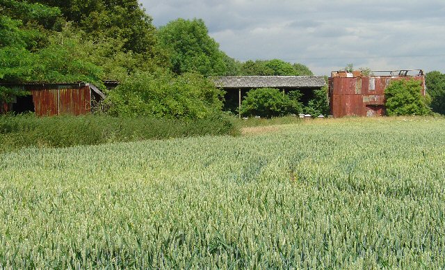
Magpie Wood is a picturesque forest located in Sussex, England. Spread across a vast area, it is known for its stunning natural beauty and diverse wildlife. The wood is predominantly composed of oak and beech trees, which provide a dense canopy that filters sunlight and creates a serene atmosphere.

The forest floor is carpeted with a variety of wildflowers, including bluebells and primroses, adding bursts of color to the landscape during springtime. The wood is also home to a rich array of wildlife, including deer, foxes, badgers, and a wide variety of bird species. Birdwatchers are often treated to the sight of magpies, woodpeckers, and tawny owls.

Magpie Wood offers a range of recreational activities for visitors to enjoy. Walking trails wind through the forest, allowing hikers to immerse themselves in nature and explore the wood's hidden treasures. There are also designated picnic areas where visitors can relax and soak in the peaceful surroundings.

The wood is managed by a local conservation organization, ensuring the preservation of its natural beauty and the protection of its wildlife. Educational programs and guided tours are often organized to raise awareness about the importance of preserving such ecosystems.

Magpie Wood is a true gem in the Sussex countryside, providing a peaceful escape from the hustle and bustle of everyday life. Whether it's for a leisurely walk, a picnic with family and friends, or an opportunity to observe and appreciate nature, Magpie Wood offers a truly enchanting experience for all who visit.

If you have any feedback on the listing, please let us know in the comments section below.

Magpie Wood Images

Images are sourced within 2km of 51.128547/-0.17937326 or Grid Reference TQ2738. Thanks to Geograph Open Source API. All images are credited.

The Hawth The Arts Centre in Crawley. Taken during the annual juggling convention held there (in 1999 in this case)
The Hawth
The Arts Centre in Crawley. Taken during the annual juggling convention held there (in 1999 in this case)
Crawley shops Always busy with a full range of shops.
Crawley shops
Always busy with a full range of shops.
Road by Three Bridges station The station at Three Bridges is on the London-Brighton line but this is also where trains heading off to Crawley or Horsham or the coast normally pass through. But I can see only one Bridge - where are the other two?
Road by Three Bridges station
The station at Three Bridges is on the London-Brighton line but this is also where trains heading off to Crawley or Horsham or the coast normally pass through. But I can see only one Bridge - where are the other two?
Hawth Theatre Council-built and owned Theatre opened in 1988
Hawth Theatre
Council-built and owned Theatre opened in 1988
County Mall Shopping Centre Shopping Mall opened in 1992
County Mall Shopping Centre
Shopping Mall opened in 1992
Crawley College College of Further Education
Crawley College
College of Further Education
Crawley Station Crawley Station, with Overline House above. The station was relocated here in the late 1960s from a former site 500yds further west.
Crawley Station
Crawley Station, with Overline House above. The station was relocated here in the late 1960s from a former site 500yds further west.
Ye Olde Punche Bowle A 15th century building which has many previous uses, including as a branch of Natwest Bank. It is currently in use as a public house
Ye Olde Punche Bowle
A 15th century building which has many previous uses, including as a branch of Natwest Bank. It is currently in use as a public house
Crawley Hospital View from South
Crawley Hospital
View from South
Manor Royal Industrial Estate, Crawley, West Sussex - Lunch Time Manor Royal Industrial Estate dominates Grid square TQ2738. The industries are varied and include various types of light to medium weight engineering, pharmaceuticals, administrative head offices, storage, etc. The view here shows one of the many snack bars that are found at strategic points round the estate. Most of the larger premises include on-site catering for employees, but there are many small companies who don't.
Manor Royal Industrial Estate, Crawley, West Sussex - Lunch Time
Manor Royal Industrial Estate dominates Grid square TQ2738. The industries are varied and include various types of light to medium weight engineering, pharmaceuticals, administrative head offices, storage, etc. The view here shows one of the many snack bars that are found at strategic points round the estate. Most of the larger premises include on-site catering for employees, but there are many small companies who don't.
County Oak Retail Park, Crawley, West Sussex The largest of several small retail parks in Crawley that are situated away from the town centre. Carpets, Furniture, Consumer electronics and electrical items, Office supplies, motoring and cycling spares, pet supplies, and a motor vehicle tyre and exhaust replacement service are all represented.
County Oak Retail Park, Crawley, West Sussex
The largest of several small retail parks in Crawley that are situated away from the town centre. Carpets, Furniture, Consumer electronics and electrical items, Office supplies, motoring and cycling spares, pet supplies, and a motor vehicle tyre and exhaust replacement service are all represented.
Astral Towers, County Oak, Crawley, West Sussex The centre of Manor Royal industrial estate contains most of the light and medium industrial premises. Various clusters of administrative offices form satellites surrounding the main estate. One such satellite is at County Oak, just across the A23 trunk road from the main estate. A typical office block is Astral Towers.
Astral Towers, County Oak, Crawley, West Sussex
The centre of Manor Royal industrial estate contains most of the light and medium industrial premises. Various clusters of administrative offices form satellites surrounding the main estate. One such satellite is at County Oak, just across the A23 trunk road from the main estate. A typical office block is Astral Towers.
Pasture between Manor Royal Industrial Estate and Gatwick Airport, Near Crawley, West Sussex "The Atrium" office block in the background is on the extreme fringe of the Manor Royal Industrial Estate. The view has been taken from a public bridleway across a field, looking south. Most of this grid square is comprised of fields such as this. There are currently (2005) plans being discussed for a second runway for Gatwick Airport. One of the options would have the proposed runway in this area.
Pasture between Manor Royal Industrial Estate and Gatwick Airport, Near Crawley, West Sussex
"The Atrium" office block in the background is on the extreme fringe of the Manor Royal Industrial Estate. The view has been taken from a public bridleway across a field, looking south. Most of this grid square is comprised of fields such as this. There are currently (2005) plans being discussed for a second runway for Gatwick Airport. One of the options would have the proposed runway in this area.
Public Footpath across fields between County Oak and Rowley Farm, Near Crawley, West Sussex. One of several long standing public rights of way in this area. This path has been in use since long before the creation of the Manor Royal Industrial Estate, immediately behind the photographer and Gatwick Airport (1.5km N of here). The path cuts diagonally SW-NE across the fields, which are growing wheat. This area is currently (2005) being suggested as a possible location for a second runway for Gatwick International Airport.
Public Footpath across fields between County Oak and Rowley Farm, Near Crawley, West Sussex.
One of several long standing public rights of way in this area. This path has been in use since long before the creation of the Manor Royal Industrial Estate, immediately behind the photographer and Gatwick Airport (1.5km N of here). The path cuts diagonally SW-NE across the fields, which are growing wheat. This area is currently (2005) being suggested as a possible location for a second runway for Gatwick International Airport.
Farm buildings near Manor Royal Industrial Estate, Crawley, West Sussex These metal clad farm buildings are in various states of dilapidation, with the central barn still intact. A row of bee hives are set in front of the barn. Wheat is growing in the field. Photo taken (looking N) from the public footpath between County Oak and Rowley Farm, just after emerging out of the Manor Royal Industrial Estate.
Farm buildings near Manor Royal Industrial Estate, Crawley, West Sussex
These metal clad farm buildings are in various states of dilapidation, with the central barn still intact. A row of bee hives are set in front of the barn. Wheat is growing in the field. Photo taken (looking N) from the public footpath between County Oak and Rowley Farm, just after emerging out of the Manor Royal Industrial Estate.
Ibis Hotel, County Oak, Crawley West Sussex. A typical airport hotel, approximately 1.5km (straight line) from Gatwick airport. On the extreme N fringe of the Manor Royal industrial estate.
Ibis Hotel, County Oak, Crawley West Sussex.
A typical airport hotel, approximately 1.5km (straight line) from Gatwick airport. On the extreme N fringe of the Manor Royal industrial estate.
First Choice Holidays plc HQ, County Oak, Crawley, West Sussex The administrative headquarters of First Choice Holidays plc, a holiday company. This office block is situated in the extreme SW corner of the grid square and is on the north western edge of the Manor Royal industrial estate. Most of the square is farmland, with the A23 trunk road sweeping through the W edge and a few hotels adjacent to the road.
First Choice Holidays plc HQ, County Oak, Crawley, West Sussex
The administrative headquarters of First Choice Holidays plc, a holiday company. This office block is situated in the extreme SW corner of the grid square and is on the north western edge of the Manor Royal industrial estate. Most of the square is farmland, with the A23 trunk road sweeping through the W edge and a few hotels adjacent to the road.
Open Space in Residential Area of Three Bridges, Crawley, West Sussex A grass covered square open space with a number of oak trees. This grid square has a high proportion of residential usage and holds approximately half of the housing in the Three Bridges neighbourhood of Crawley. Such open spaces are common throughout the various Crawley neighbourhoods.
Open Space in Residential Area of Three Bridges, Crawley, West Sussex
A grass covered square open space with a number of oak trees. This grid square has a high proportion of residential usage and holds approximately half of the housing in the Three Bridges neighbourhood of Crawley. Such open spaces are common throughout the various Crawley neighbourhoods.
Show me another place!

Magpie Wood is located at Grid Ref: TQ2738 (Lat: 51.128547, Lng: -0.17937326)

Administrative County: West Sussex

District: Crawley

Police Authority: Sussex

What 3 Words

///acted.stored.bolts. Near Langley Green, West Sussex

Nearby Locations

County Oak Magpie Wood

Related Wikis

Northgate, West Sussex

Northgate is one of the 14 residential neighbourhoods in Crawley, a town and borough in West Sussex, England. Crawley was planned and laid out as a New...

Northgate & Three Bridges (electoral division)

Northgate & Three Bridges is an electoral division of West Sussex in the United Kingdom, and returns one member to sit on West Sussex County Council....

Langley Green, West Sussex

Langley Green is a one of 14 neighbourhoods within the town of Crawley in West Sussex, England. Langley Green is in the north-west of the town and is bordered...

Noor Mosque, Crawley

Noor mosque is an Ahmadi mosque in Crawley in the borough of West Sussex, England. The mosque was opened on 18 January 2014. == References ==

Manor Royal

Manor Royal is an industrial zone within the town of Crawley in West Sussex, England. Manor Royal is in the north of the town near to Gatwick Airport....

Hazelwick School

Hazelwick School is a co-educational comprehensive school with academy status for pupils aged 11 to 18, located in Crawley, West Sussex, England. Its alumni...

West Green, West Sussex

West Green is one of the 14 residential neighbourhoods in Crawley, a town and borough in West Sussex, England. Crawley was planned and laid out as a New...

Oakwood F.C.

Oakwood Football Club are a football club based in Crawley, England. They were established in 1962 and joined the Sussex County League Division Three in...

Nearby Amenities

Located within 500m of 51.128547,-0.17937326
Crossing
Crossing: uncontrolled
Crossing Island: yes
Crossing Markings: dots
Kerb: lowered
Tactile Paving: yes
Lat/Long: 51.129437/-0.1863071
Crossing
Bicycle: yes
Crossing: traffic_signals
Crossing Markings: dots
Crossing Ref: toucan
Kerb: lowered
Tactile Paving: yes
Traffic Signals: pedestrian_crossing
Lat/Long: 51.130288/-0.1736815
Crossing
Bicycle: yes
Crossing: unmarked
Crossing Markings: no
Kerb: lowered
Tactile Paving: yes
Lat/Long: 51.1301127/-0.1738987
Manor Royal
Is In: West Sussex, England, UK
Place: village
Lat/Long: 51.1321256/-0.1776546
Crossing
Lat/Long: 51.126551/-0.18573
Bus Stop
Manor Royal West
Bench: yes
Bin: yes
Bus: yes
Departures Board: realtime
Naptan AtcoCode: 4400CY0130
Naptan NaptanCode: wsxajtga
Operator: MetroBus
Public Transport: platform
Shelter: yes
Tactile Paving: no
Lat/Long: 51.1298429/-0.183895
Bus Stop
Manor Royal West
Bus: yes
Departures Board: realtime
Naptan AtcoCode: 4400CY0131
Naptan Bearing: W
Naptan CommonName: Manor Royal West
Naptan Indicator: adj Crompton Way
Naptan Landmark: Crompton Way
Naptan NaptanCode: wsxajtgd
Naptan PlusbusZoneRef: CRAWLEY
Naptan Street: Manor Royal
Operator: MetroBus
Public Transport: platform
Shelter: yes
Source: naptan_import
Lat/Long: 51.1297457/-0.1845014
Bus Stop
Manor Royal Central
Bench: yes
Bin: yes
Bus: yes
Naptan AtcoCode: 4400CY0132
Naptan Bearing: W
Naptan CommonName: Central
Naptan Indicator: opp
Naptan Landmark: Faraday Road
Naptan NaptanCode: wsxajtgj
Naptan PlusbusZoneRef: CRAWLEY
Naptan ShortCommonName: Manor Royal Central
Naptan Street: Manor Royal
Public Transport: platform
Shelter: yes
Source: naptan_import
Tactile Paving: no
Lat/Long: 51.1296101/-0.1785745
Bus Stop
Manor Royal Central
Bus: yes
Naptan AtcoCode: 4400CY0133
Naptan Bearing: E
Naptan CommonName: Central
Naptan Indicator: adj
Naptan Landmark: Faraday Road
Naptan NaptanCode: wsxajtgm
Naptan PlusbusZoneRef: CRAWLEY
Naptan ShortCommonName: Manor Royal Central
Naptan Street: Manor Royal
Public Transport: platform
Source: naptan_import
Lat/Long: 51.1297654/-0.1773047
Bus Stop
Manor Royal Central
Bus: yes
Naptan AtcoCode: 4400CY0134
Naptan Bearing: N
Naptan CommonName: Central
Naptan Indicator: adj
Naptan Landmark: Manor Royal
Naptan NaptanCode: wsxajtgp
Naptan PlusbusZoneRef: CRAWLEY
Naptan ShortCommonName: Manor Royal Central
Naptan Street: Faraday Road
Naptan Verified: no
Public Transport: platform
Source: naptan_import
Lat/Long: 51.1303688/-0.1781296
Bus Stop
Faraday Road
Bus: yes
Naptan AtcoCode: 4400CY0147
Naptan Bearing: N
Naptan CommonName: Faraday Road
Naptan Indicator: opp Kelvin Way
Naptan Landmark: Kelvin Way
Naptan NaptanCode: wsxajtmj
Naptan PlusbusZoneRef: CRAWLEY
Naptan Street: Faraday Road
Naptan Verified: no
Public Transport: platform
Source: naptan_import
Lat/Long: 51.1323336/-0.1783404
Bus Stop
Faraday Road
Bus: yes
Naptan AtcoCode: 4400CY0148
Naptan Bearing: S
Naptan CommonName: Faraday Road
Naptan Indicator: adj Kelvin Way
Naptan Landmark: Kelvin Way
Naptan NaptanCode: wsxajtmp
Naptan PlusbusZoneRef: CRAWLEY
Naptan Street: Faraday Road
Naptan Verified: no
Public Transport: platform
Source: naptan_import
Lat/Long: 51.1317946/-0.1781128
Bus Stop
Woodside Road
Bus: yes
Naptan AtcoCode: 4400CY0232
Naptan Bearing: E
Naptan CommonName: Woodside Road
Naptan Indicator: outside 149
Naptan Landmark: Green Lane
Naptan NaptanCode: wsxamajp
Naptan PlusbusZoneRef: CRAWLEY
Naptan Street: Woodfield Road
Naptan Verified: yes
Public Transport: platform
Source: naptan_import
Lat/Long: 51.1249803/-0.1752231
Post Box
Ref: RH10 68
Lat/Long: 51.1296917/-0.1830761
Crossing
Bicycle: yes
Crossing: unmarked
Crossing Markings: no
Kerb: lowered
Tactile Paving: yes
Lat/Long: 51.1299929/-0.1744298
Crossing
Bicycle: yes
Crossing: unmarked
Crossing Markings: no
Kerb: lowered
Lat/Long: 51.1298166/-0.1753482
Crossing
Bicycle: yes
Crossing: traffic_signals
Crossing Markings: dots
Crossing Ref: toucan
Kerb: lowered
Tactile Paving: yes
Lat/Long: 51.1295124/-0.1780572
Barrier: bollard
Source: Local Knowledge
Lat/Long: 51.1259708/-0.1816179
Traffic Signals
Traffic Signals Direction: backward
Lat/Long: 51.1294884/-0.1780575
Telephone
Booth: K6
Covered: booth
Operator: BT
Operator Wikidata: Q593786
Lat/Long: 51.1248321/-0.1761064
Barrier: lift_gate
Lat/Long: 51.1312991/-0.1824388
Crossing
Lat/Long: 51.12655/-0.1854497
Crossing
Crossing: uncontrolled
Crossing Markings: zebra
Crossing Ref: zebra
Kerb: lowered
Tactile Paving: yes
Lat/Long: 51.1313588/-0.1805782
Crossing
Crossing: unmarked
Crossing Markings: no
Lat/Long: 51.1298423/-0.1854292
Barrier: lift_gate
Lat/Long: 51.130872/-0.1778373
Crossing
Bicycle: yes
Crossing: unmarked
Crossing Markings: no
Kerb: lowered
Tactile Paving: yes
Lat/Long: 51.1305034/-0.1733022
Crossing
Bicycle: yes
Crossing: unmarked
Crossing Markings: no
Kerb: lowered
Tactile Paving: yes
Lat/Long: 51.1299706/-0.1760571
Crossing
Bicycle: yes
Crossing: unmarked
Crossing Markings: no
Kerb: lowered
Tactile Paving: yes
Lat/Long: 51.1299558/-0.1762019
Crossing
Bicycle: yes
Crossing: unmarked
Crossing Markings: no
Kerb: lowered
Tactile Paving: yes
Lat/Long: 51.130111/-0.175277
Crossing
Bicycle: yes
Crossing: unmarked
Crossing Markings: no
Kerb: lowered
Tactile Paving: yes
Lat/Long: 51.12989/-0.1766821
Crossing
Bicycle: yes
Crossing: traffic_signals
Crossing Markings: dots
Crossing Ref: toucan
Kerb: lowered
Tactile Paving: yes
Lat/Long: 51.1298036/-0.1780016
Crossing
Bicycle: yes
Crossing: unmarked
Crossing Markings: no
Kerb: lowered
Tactile Paving: yes
Lat/Long: 51.129827/-0.1794116
Crossing
Bicycle: yes
Crossing: unmarked
Crossing Markings: no
Kerb: lowered
Tactile Paving: yes
Lat/Long: 51.1298652/-0.1810028
Crossing
Bicycle: yes
Crossing: unmarked
Crossing Markings: no
Kerb: lowered
Tactile Paving: yes
Lat/Long: 51.1298708/-0.1811394
Crossing
Bicycle: yes
Crossing: uncontrolled
Crossing Markings: no
Kerb: lowered
Proposed Crossing: traffic_signals
Proposed Crossing Ref: toucan
Tactile Paving: yes
Lat/Long: 51.1299084/-0.183055
Crossing
Bicycle: yes
Crossing: unmarked
Crossing Markings: no
Kerb: lowered
Tactile Paving: yes
Lat/Long: 51.129954/-0.1848026
Post Box
Brand: Royal Mail
Brand Wikidata: Q638098
Brand Wikipedia: en:Royal Mail
Collection Times: Mo-Fr 09:00; Sa 07:00; Su off
Drive Through: no
Operator: Royal Mail
Operator Wikidata: Q638098
Post Box Type: pillar
Ref: RH10 88D
Royal Cypher: EIIR
Royal Cypher Wikidata: Q33102113
Source: survey
Lat/Long: 51.1304494/-0.1734945
Entrance: yes
Lat/Long: 51.1271523/-0.1823858
Entrance: yes
Lat/Long: 51.1266328/-0.1818887
Give Way
Lat/Long: 51.129867/-0.1855179
Washout Hydrant
Fire Hydrant
Emergency: fire_hydrant
Fire Hydrant Type: underground
Survey Date: 2018-11-11
Water Source: main
Lat/Long: 51.129911/-0.1763325
Washout Hydrant
Fire Hydrant
Emergency: fire_hydrant
Fire Hydrant Type: underground
Survey Date: 2018-11-11
Water Source: main
Lat/Long: 51.125739/-0.1740531
Bus Stop
Business Quarter South
Bus: yes
Naptan AtcoCode: 4400CY0607
Naptan Bearing: N
Naptan NaptanCode: wsxwadmd
Naptan Street: Crawley Business Quarter
Naptan Verified: yes
Public Transport: platform
Source: gps
Lat/Long: 51.1303928/-0.1811761
Crossing
Crossing: unmarked
Crossing Island: yes
Crossing Markings: no
Lat/Long: 51.1297681/-0.1854158
Crossing
Bicycle: yes
Crossing: unmarked
Crossing Markings: no
Kerb: lowered
Tactile Paving: yes
Lat/Long: 51.1296473/-0.1848041
Crossing
Bicycle: yes
Crossing: traffic_signals
Crossing Markings: dots
Crossing Ref: toucan
Kerb: lowered
Tactile Paving: yes
Lat/Long: 51.1296123/-0.1829247
Crossing
Bicycle: yes
Crossing: unmarked
Crossing Markings: no
Kerb: lowered
Tactile Paving: yes
Lat/Long: 51.1295827/-0.1819635
Crossing
Bicycle: yes
Crossing: unmarked
Crossing Markings: no
Kerb: lowered
Tactile Paving: yes
Lat/Long: 51.1295728/-0.1814329
Crossing
Bicycle: yes
Crossing: unmarked
Crossing Markings: no
Kerb: lowered
Tactile Paving: yes
Lat/Long: 51.1295582/-0.180879
Crossing
Bicycle: yes
Crossing: unmarked
Crossing Markings: no
Kerb: lowered
Tactile Paving: yes
Lat/Long: 51.1295494/-0.1804361
Crossing
Bicycle: yes
Crossing: unmarked
Crossing Markings: no
Kerb: lowered
Tactile Paving: yes
Lat/Long: 51.1295345/-0.1796626
Bus Stop
Business Quarter South
Bus: yes
Naptan AtcoCode: 4400CY0606
Naptan Bearing: S
Naptan NaptanCode: wsxwadma
Naptan Street: Crawley Business Quarter
Public Transport: platform
Lat/Long: 51.1303936/-0.180906
Crossing
Bicycle: yes
Crossing: traffic_signals
Crossing Island: no
Crossing Markings: dots
Crossing Ref: toucan
Kerb: flush
Tactile Paving: yes
Traffic Signals: pedestrian_crossing
Lat/Long: 51.1297362/-0.1817675
Crossing
Bicycle: yes
Crossing: traffic_signals
Crossing Markings: dots
Crossing Ref: toucan
Kerb: lowered
Tactile Paving: yes
Lat/Long: 51.1296547/-0.1782635
Crossing
Bicycle: yes
Crossing: traffic_signals
Crossing Markings: dots
Crossing Ref: toucan
Kerb: lowered
Tactile Paving: yes
Lat/Long: 51.1296554/-0.1778235
Traffic Signals
Traffic Signals: signal
Traffic Signals Direction: forward
Lat/Long: 51.1298051/-0.1861903
Traffic Signals
Traffic Signals Direction: forward
Lat/Long: 51.1298389/-0.1780061
Traffic Signals
Traffic Signals Direction: forward
Lat/Long: 51.1296585/-0.1777425
Traffic Signals
Traffic Signals Direction: backward
Lat/Long: 51.1296559/-0.1783253
Traffic Signals
Traffic Signals Direction: forward
Lat/Long: 51.1299332/-0.1830546
Traffic Signals
Traffic Signals Direction: forward
Lat/Long: 51.1297626/-0.1826892
Traffic Signals
Traffic Signals Direction: forward
Lat/Long: 51.1295695/-0.1829254
Traffic Signals
Traffic Signals Direction: backward
Lat/Long: 51.1297813/-0.1833827
Crossing
Bicycle: yes
Crossing: traffic_signals
Crossing Island: no
Crossing Markings: dots
Crossing Ref: toucan
Kerb: flush
Tactile Paving: yes
Lat/Long: 51.1297957/-0.1841302
Traffic Signals
Lat/Long: 51.1296155/-0.1860149
Crossing
Bicycle: yes
Crossing: traffic_signals
Crossing Markings: dots
Crossing Ref: toucan
Kerb: lowered
Tactile Paving: yes
Lat/Long: 51.1297422/-0.186032
Barrier: lift_gate
Lat/Long: 51.1295839/-0.1848078
Tourism: artwork
Lat/Long: 51.1298974/-0.1859629
Crossing
Crossing: zebra
Crossing Markings: zebra
Lat/Long: 51.1304673/-0.1847804
Crossing
Crossing: zebra
Crossing Markings: zebra
Lat/Long: 51.1304654/-0.1847213
Crossing
Crossing: zebra
Crossing Markings: zebra
Lat/Long: 51.1302741/-0.1844991
Crossing
Crossing: zebra
Crossing Markings: zebra
Lat/Long: 51.1312052/-0.1848899
Crossing
Crossing: zebra
Crossing Markings: zebra
Lat/Long: 51.1308864/-0.1849094
Crossing
Crossing: zebra
Crossing Markings: zebra
Lat/Long: 51.130565/-0.1846046
Addr City: Crawley
Addr Flats: 2,3B,4,5A,6
Addr Postcode: RH10 8TT
Addr Street: Hollin Court
Entrance: staircase
Level: 1-3
Lat/Long: 51.1292563/-0.1861708
Addr City: Crawley
Addr Postcode: RH10 8TT
Addr Street: Hollin Court
Entrance: staircase
Level: 10-15
Lat/Long: 51.1291182/-0.1862439
Addr City: Crawley
Addr Flats: 9
Addr Postcode: RH10 8TT
Addr Street: Hollin Court
Entrance: yes
Level: 1
Lat/Long: 51.1291106/-0.1861776
Addr City: Crawley
Addr Flats: 16-21
Addr Postcode: RH10 8TT
Addr Street: Hollin Court
Entrance: staircase
Level: 0
Lat/Long: 51.1290187/-0.1862238
Waste Basket
Lat/Long: 51.1260308/-0.1822195
Waste Basket
Waste: dog_excrement
Lat/Long: 51.126025/-0.1821946
Waste Basket
Lat/Long: 51.1295957/-0.1787142
Addr City: Crawley
Addr Postcode: RH10 8TT
Addr Street: Hollin Court
Entrance: yes
Level: 1a,1b
Lat/Long: 51.1292372/-0.1861076
Addr Flats: 26-38;55
Entrance: staircase
Lat/Long: 51.1260907/-0.1758209
Addr Flats: 15-25;39-43;54
Entrance: staircase
Lat/Long: 51.1260167/-0.1752803
Addr Flats: 1-14;44-53
Entrance: staircase
Lat/Long: 51.1259397/-0.1747262
Barrier: bollard
Lat/Long: 51.1258242/-0.1794666
Addr Flats: 1-4
Entrance: yes
Lat/Long: 51.1252794/-0.1744961
Addr Flats: 8
Entrance: yes
Lat/Long: 51.125424/-0.1743891
Addr Flats: 1-10
Entrance: yes
Lat/Long: 51.1252166/-0.1750375
Leisure: picnic_table
Lat/Long: 51.1267075/-0.1832316
Leisure: picnic_table
Lat/Long: 51.126697/-0.1831607
Leisure: picnic_table
Lat/Long: 51.1266928/-0.183114
Entrance: yes
Lat/Long: 51.1272128/-0.1821102
Entrance: yes
Lat/Long: 51.1266781/-0.1823386
Leisure: picnic_table
Lat/Long: 51.1265842/-0.1820781
Leisure: picnic_table
Lat/Long: 51.1266284/-0.1822583
Leisure: picnic_table
Lat/Long: 51.1265888/-0.1820104
Leisure: picnic_table
Lat/Long: 51.1265808/-0.1819399
Leisure: picnic_table
Lat/Long: 51.1266093/-0.1818389
Leisure: picnic_table
Lat/Long: 51.1266127/-0.1819345
Leisure: picnic_table
Lat/Long: 51.1266258/-0.1820185
Entrance: yes
Lat/Long: 51.1279078/-0.182494
Entrance: yes
Lat/Long: 51.1270285/-0.1859419
Entrance: yes
Lat/Long: 51.1271432/-0.185926
Entrance: yes
Lat/Long: 51.1272875/-0.1858816
Entrance: yes
Lat/Long: 51.1273934/-0.1858359
Entrance: yes
Lat/Long: 51.127488/-0.1857203
Entrance: yes
Lat/Long: 51.1276357/-0.1855642
Entrance: yes
Lat/Long: 51.1277527/-0.1855567
Entrance: yes
Lat/Long: 51.1278599/-0.1855128
Entrance: yes
Lat/Long: 51.1278267/-0.1850816
Entrance: yes
Lat/Long: 51.1277176/-0.1851411
Entrance: yes
Lat/Long: 51.1276108/-0.1851732
Entrance: yes
Lat/Long: 51.1274952/-0.1851786
Entrance: yes
Lat/Long: 51.1271653/-0.1851688
Entrance: yes
Lat/Long: 51.1281294/-0.1837868
Entrance: yes
Lat/Long: 51.1277392/-0.1845038
Entrance: yes
Lat/Long: 51.1272369/-0.1832622
Entrance: yes
Lat/Long: 51.1276223/-0.1834636
Crossing
Crossing: uncontrolled
Crossing Markings: zebra
Crossing Ref: zebra
Kerb: lowered
Tactile Paving: yes
Lat/Long: 51.1313816/-0.1813663
Crossing
Bicycle: yes
Crossing: traffic_signals
Crossing Markings: dots
Crossing Ref: toucan
Kerb: lowered
Tactile Paving: yes
Lat/Long: 51.1299661/-0.185767
Crossing
Bicycle: yes
Crossing: traffic_signals
Crossing Markings: dots
Crossing Ref: toucan
Kerb: lowered
Tactile Paving: yes
Lat/Long: 51.1295969/-0.1860794
The data included in this document is from www.openstreetmap.org. The data is made available under ODbL.

Have you been to Magpie Wood?

Leave your review of Magpie Wood below (or comments, questions and feedback).