Tasker's Plantation

Wood, Forest in Lincolnshire East Lindsey

England

Tasker's Plantation

Farm track and footpath to Horncastle
Farm track and footpath to Horncastle Credit: Jonathan Thacker

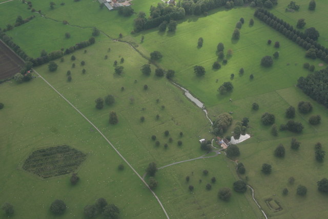
Tasker's Plantation is a woodland area located in Lincolnshire, England. Covering an expansive area of land, it is known for its lush greenery and diverse range of plant species. The plantation is situated in a rural setting, surrounded by picturesque countryside and rolling hills.

The woodland is primarily composed of various species of trees, including oak, beech, and pine. These trees create a dense canopy, providing shade and shelter for the many animal species that call Tasker's Plantation home. The forest floor is adorned with a rich carpet of ferns, mosses, and wildflowers, adding to the overall beauty and biodiversity of the area.

Tasker's Plantation is not only a haven for plant and animal life but also a popular destination for outdoor enthusiasts. There are numerous walking trails and nature paths that wind through the woodland, allowing visitors to explore and appreciate the natural surroundings. The plantation is also equipped with picnic areas and benches, providing a perfect spot for relaxation and enjoying the serene ambiance.

The plantation is managed and maintained by local authorities, ensuring the preservation of this natural treasure. Conservation efforts are in place to protect the delicate ecosystem and promote sustainable practices. The area is regularly monitored and managed to prevent invasive species and maintain the health of the woodland.

Overall, Tasker's Plantation in Lincolnshire is a captivating and vibrant woodland, offering a peaceful retreat for nature lovers and an opportunity to immerse oneself in the beauty of the natural world.

If you have any feedback on the listing, please let us know in the comments section below.

Tasker's Plantation Images

Images are sourced within 2km of 53.1757/-0.093984783 or Grid Reference TF2765. Thanks to Geograph Open Source API. All images are credited.

Farm track and footpath to Horncastle
Autumn sown crop near Mareham on the Hill Horncastle in the distance.
Autumn sown crop near Mareham on the Hill
Horncastle in the distance.
Scrivelsby Park: aerial 2022 (1)
Scrivelsby Park: aerial 2022 (2)
The Lion Gateway With the Lion Lodge through the arch at Scrivelsby Manor, the holder of the Manor being the King's Champion
The Lion Gateway
With the Lion Lodge through the arch at Scrivelsby Manor, the holder of the Manor being the King's Champion
Cropmarks on fields S of Scrivelsby Spinney: aerial 2022
The Lion Gateway For Scrivelsby Court, with the Lion Lodge behind the arch
The Lion Gateway
For Scrivelsby Court, with the Lion Lodge behind the arch
Former church of St. Benedict, Wood Enderby Rebuilt in 1868 by George Hackford. Now an architectural store.
Former church of St. Benedict, Wood Enderby
Rebuilt in 1868 by George Hackford. Now an architectural store.
Churchyard and Manor Farm
View from the churchyard Wood Enderby
Footpath to Moorby
Footpath to Moorby
Cottage in Wood Enderby This basic plan and style was commonplace in Lincolnshire from the late seventeenth century through to the early nineteenth century.
Cottage in Wood Enderby
This basic plan and style was commonplace in Lincolnshire from the late seventeenth century through to the early nineteenth century.
Hard standing, High Lane, Mareham on the Hill Here is marked a "reservoir" on the OS map.
Hard standing, High Lane, Mareham on the Hill
Here is marked a "reservoir" on the OS map.
Field margin off High Lane, Mareham on the Hill Looking towards Northfield Plantation.
Field margin off High Lane, Mareham on the Hill
Looking towards Northfield Plantation.
Three little trees on the lane leading westwards from Scrivelsby Somewhat the worse for their covering of ivy, which provides the only greenery on this late April day.
Three little trees on the lane leading westwards from Scrivelsby
Somewhat the worse for their covering of ivy, which provides the only greenery on this late April day.
Scrivelsby Park: aerial 2017
Scrivelsby Park: aerial 2020 (1) See <span class="nowrap"><a title="https://www.heritagegateway.org.uk/Gateway/Results_Single.aspx?uid=MLI42728&resourceID=1006" rel="nofollow ugc noopener" href="https://www.heritagegateway.org.uk/Gateway/Results_Single.aspx?uid=MLI42728&resourceID=1006">Link</a><img style="margin-left:2px;" alt="External link" title="External link - shift click to open in new window" src="https://s1.geograph.org.uk/img/external.png" width="10" height="10"/></span>
Scrivelsby Park: aerial 2020 (1)
See LinkExternal link
Scrivelsby Park: aerial 2020 (2) See <span class="nowrap"><a title="https://www.heritagegateway.org.uk/Gateway/Results_Single.aspx?uid=MLI42728&resourceID=1006" rel="nofollow ugc noopener" href="https://www.heritagegateway.org.uk/Gateway/Results_Single.aspx?uid=MLI42728&resourceID=1006">Link</a><img style="margin-left:2px;" alt="External link" title="External link - shift click to open in new window" src="https://s1.geograph.org.uk/img/external.png" width="10" height="10"/></span>

The rectangular feature bottom right is thought to be a fishpond rather than a moated site - see <span class="nowrap"><a title="https://www.heritagegateway.org.uk/Gateway/Results_Single.aspx?uid=MLI40790&resourceID=1006" rel="nofollow ugc noopener" href="https://www.heritagegateway.org.uk/Gateway/Results_Single.aspx?uid=MLI40790&resourceID=1006">Link</a><img style="margin-left:2px;" alt="External link" title="External link - shift click to open in new window" src="https://s1.geograph.org.uk/img/external.png" width="10" height="10"/></span> and <span class="nowrap"><a title="https://www.heritagegateway.org.uk/Gateway/Results_Single.aspx?uid=1017390&resourceID=5" rel="nofollow ugc noopener" href="https://www.heritagegateway.org.uk/Gateway/Results_Single.aspx?uid=1017390&resourceID=5">Link</a><img style="margin-left:2px;" alt="External link" title="External link - shift click to open in new window" src="https://s1.geograph.org.uk/img/external.png" width="10" height="10"/></span>
Scrivelsby Park: aerial 2020 (2)
See LinkExternal link The rectangular feature bottom right is thought to be a fishpond rather than a moated site - see LinkExternal link and LinkExternal link
Show me another place!

Tasker's Plantation is located at Grid Ref: TF2765 (Lat: 53.1757, Lng: -0.093984783)

Administrative County: Lincolnshire

District: East Lindsey

Police Authority: Lincolnshire

What 3 Words

///resolved.fearfully.cube. Near Horncastle, Lincolnshire

Related Wikis

Scrivelsby

Scrivelsby is a village and ecclesiastical parish in the East Lindsey district of the County of Lincolnshire, England. It is situated 2 miles (3.2 km...

Wood Enderby

Wood Enderby is a village and civil parish in the East Lindsey district of Lincolnshire, England. It is situated approximately 4 miles (6 km) south from...

Mareham on the Hill

Mareham on the Hill is a village and civil parish about 2.5 miles (4.0 km) south-east from the town of Horncastle, Lincolnshire, England. Mareham on the...

Dalderby

Dalderby is a village and former civil parish, now in the parish of Roughton, in the East Lindsey district of Lincolnshire, England. It is situated approximately...

Moorby

Moorby is a small village and former civil parish, now in the parish of Claxby with Moorby, in the East Lindsey district of Lincolnshire, England. The...

Haltham Wood

Haltham Wood is a woodland in the parish of Haltham in the East Lindsey district of Lincolnshire, England. == References ==
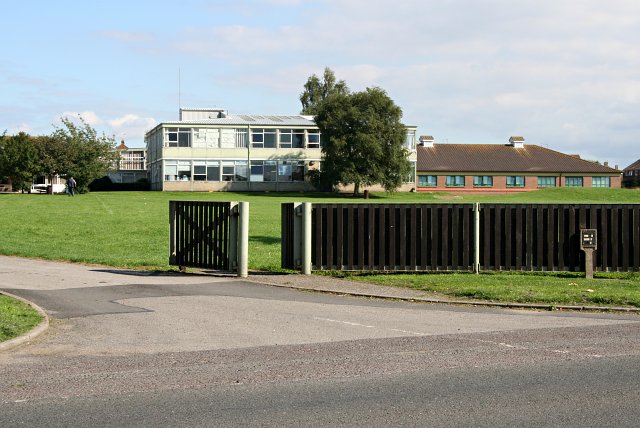
Banovallum School

The Banovallum School is a co-educational secondary school located in Horncastle, Lincolnshire, England. == History == The school was built in the early...

Wilksby

Wilksby is a hamlet in the civil parish of Wood Enderby, in the East Lindsey district of Lincolnshire. A former civil parish in itself, it was merged with...

Nearby Amenities

Located within 500m of 53.1757,-0.093984783
Note: End of Public Highway
Lat/Long: 53.1765943/-0.0904959
Barrier: cattle_grid
Lat/Long: 53.1772046/-0.0915352
Power: pole
Source: Bing
Lat/Long: 53.1781036/-0.0947798
Power: pole
Source: Bing
Lat/Long: 53.1777553/-0.09924
Power: pole
Source: Bing
Lat/Long: 53.1789885/-0.0944821
Power: pole
Source: Bing
Lat/Long: 53.1772757/-0.0965407
Power: pole
Source: Bing
Lat/Long: 53.179916/-0.0941817
Power: pole
Source: Bing
Lat/Long: 53.1770297/-0.0951325
Ford: yes
Lat/Long: 53.1794239/-0.0905346
Power: pole
Source: Bing
Lat/Long: 53.1775192/-0.0979301
Power: pole
Source: Bing
Lat/Long: 53.1772042/-0.0928835
Power: pole
Source: Bing
Lat/Long: 53.1773111/-0.0913976
Barrier: cattle_grid
Lat/Long: 53.1714711/-0.0950857
Barrier: cattle_grid
Lat/Long: 53.1770796/-0.0923964
Power: pole
Source: Bing
Lat/Long: 53.1771346/-0.093781
Holme Wood Farm
Place: farm
Source: Bing
Lat/Long: 53.1772664/-0.0879878
Long Farm
Place: farm
Source: Bing
Lat/Long: 53.1778351/-0.0910918
Manor Farm
Place: farm
Source: Bing
Lat/Long: 53.1781077/-0.0891345
Archaeological Site: fortification
Historic: archaeological_site
Source: Bing
Lat/Long: 53.1759319/-0.1005125
Scrivelsby Park
Place: locality
Source: Bing
Lat/Long: 53.1748189/-0.0964544
The data included in this document is from www.openstreetmap.org. The data is made available under ODbL.

Have you been to Tasker's Plantation?

Leave your review of Tasker's Plantation below (or comments, questions and feedback).