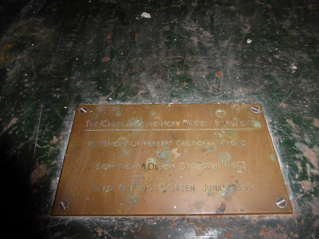
Empshott Green

Settlement in Hampshire East Hampshire

England

Empshott Green

Farmland, Selborne A crop of wheat to the west of Bradshott Hall.
Farmland, Selborne Credit: Andrew Smith

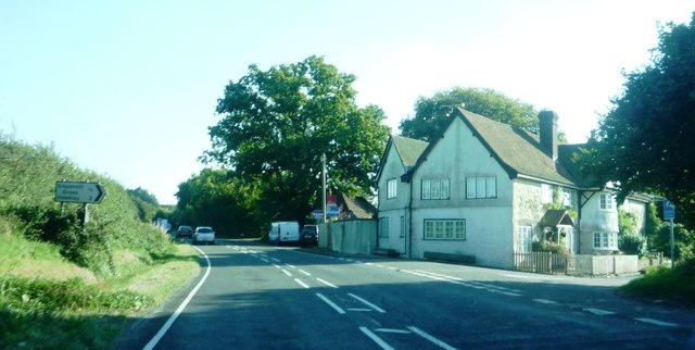
Empshott Green is a picturesque village located in the county of Hampshire, England. Situated in the South Downs National Park, it is nestled amongst rolling hills and offers stunning views of the surrounding countryside. The village is part of the East Hampshire district and is surrounded by other charming villages such as Hawkley and Selborne.

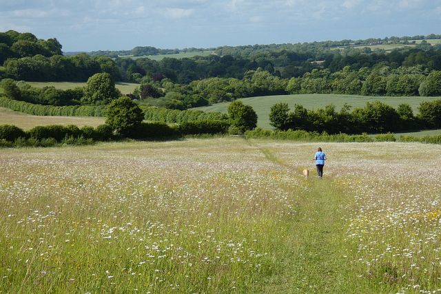
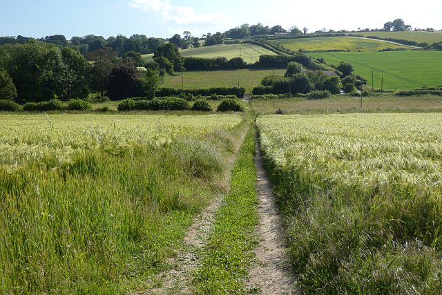
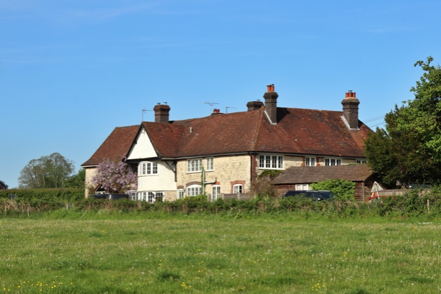
Empshott Green is known for its tranquility and natural beauty, making it a popular destination for those seeking a peaceful retreat. The village is characterized by its idyllic setting, with thatched cottages, historic buildings, and well-maintained gardens dotted throughout. The local community takes pride in preserving the village's rural charm and heritage.

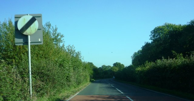
Nature enthusiasts will be delighted by the abundance of walking and cycling trails that crisscross the area, allowing visitors to explore the stunning landscapes and encounter local wildlife. The village is also in close proximity to the South Downs Way, a popular long-distance footpath that stretches across the South Downs.

Although Empshott Green is primarily a residential area, there are a few amenities available to residents and visitors. The village has a small community hall that hosts various events and gatherings. Additionally, there are a few local businesses nearby, including a farm shop and a traditional pub, where locals and visitors can enjoy a meal or a drink.

Overall, Empshott Green offers a peaceful and picturesque retreat for those seeking a break from the hustle and bustle of city life. Its natural beauty, charming architecture, and sense of community make it a hidden gem within the Hampshire countryside.

If you have any feedback on the listing, please let us know in the comments section below.

Empshott Green Images

Images are sourced within 2km of 51.073781/-0.935851 or Grid Reference SU7431. Thanks to Geograph Open Source API. All images are credited.

Farmland, Selborne A crop of wheat to the west of Bradshott Hall.
Farmland, Selborne
A crop of wheat to the west of Bradshott Hall.
Grassland, Hawkley Descending through a flowery meadow, the footpath connecting Noar Hill and Selborne.
Grassland, Hawkley
Descending through a flowery meadow, the footpath connecting Noar Hill and Selborne.
Farmland, Newton Valence Descending through barley, the restricted byway below King's Farm.
Farmland, Newton Valence
Descending through barley, the restricted byway below King's Farm.
Oast House Twin round kiln oast house.
Oast House
Twin round kiln oast house.
B3006 at Empshott Junction of B3006 with minor road to Empshott Green
B3006 at Empshott
Junction of B3006 with minor road to Empshott Green
Speed limit change at edge of Empshott village Taken travelling southbound on the B3006
Speed limit change at edge of Empshott village
Taken travelling southbound on the B3006
Holy Rood, Empshott: family memorial
Holy Rood, Empshott: memorial to a general's daughter Also see <span class="nowrap"><a title="https://en.wikipedia.org/wiki/Lord_William_Seymour_(British_Army_officer)" rel="nofollow ugc noopener" href="https://en.wikipedia.org/wiki/Lord_William_Seymour_(British_Army_officer)">Link</a><img style="margin-left:2px;" alt="External link" title="External link - shift click to open in new window" src="https://s1.geograph.org.uk/img/external.png" width="10" height="10"/></span>
Holy Rood, Empshott: memorial to a general's daughter
Also see LinkExternal link
Holy Rood, Empshott: war memorial
Holy Rood, Empshott:  memorial on the organ
Holy Rood, Empshott: memorial on the organ
Holy Rood, Empshott:  memorial to a churchwarden
Holy Rood, Empshott: memorial to a churchwarden
Holy Rood, Empshott:  The Ten Commandments (i to iv)
Holy Rood, Empshott: The Ten Commandments (i to iv)
Holy Rood, Empshott:  The  Ten Commandments (v to x)
Holy Rood, Empshott: The Ten Commandments (v to x)
Holy Rood, Empshott:  memorial to a sapper Also see <span class="nowrap"><a title="http://www.cwgc.org/find-war-dead/casualty/719992/BURTON,%20FRANK" rel="nofollow ugc noopener" href="http://www.cwgc.org/find-war-dead/casualty/719992/BURTON,%20FRANK">Link</a><img style="margin-left:2px;" alt="External link" title="External link - shift click to open in new window" src="https://s1.geograph.org.uk/img/external.png" width="10" height="10"/></span>
Holy Rood, Empshott: memorial to a sapper
Also see LinkExternal link
Holy Rood, Empshott:  memorial to a North Devonian
Holy Rood, Empshott: memorial to a North Devonian
Holy Rood, Empshott:  memorial to a Major Also see <span class="nowrap"><a title="http://www.cwgc.org/find-war-dead/casualty/322923/JOHNSTONE,%20JAMES%20HENRY%20WALLER" rel="nofollow ugc noopener" href="http://www.cwgc.org/find-war-dead/casualty/322923/JOHNSTONE,%20JAMES%20HENRY%20WALLER">Link</a><img style="margin-left:2px;" alt="External link" title="External link - shift click to open in new window" src="https://s1.geograph.org.uk/img/external.png" width="10" height="10"/></span>
Holy Rood, Empshott: memorial to a Major
Also see LinkExternal link
Holy Rood, Empshott:  memorial to a vicar's mother Harnett's father was Falkiner Minchin Harnett, who was District Inspector of the Royal Irish Constabulary at Cashel, County Tipperary, Ireland. He was educated at the University of Durham and ordained in 1903. He came to Empshott in 1915 after curacies at Oldswinford, Southampton and Bournemouth. He married Caroline Elise Blunt, daughter of Maj.-Gen. Grant Blunt and Rachel Eliza Pile, on 2 September 1919. In 1924 he left to become Vicar of Hatherden
Holy Rood, Empshott: memorial to a vicar's mother
Harnett's father was Falkiner Minchin Harnett, who was District Inspector of the Royal Irish Constabulary at Cashel, County Tipperary, Ireland. He was educated at the University of Durham and ordained in 1903. He came to Empshott in 1915 after curacies at Oldswinford, Southampton and Bournemouth. He married Caroline Elise Blunt, daughter of Maj.-Gen. Grant Blunt and Rachel Eliza Pile, on 2 September 1919. In 1924 he left to become Vicar of Hatherden
Show me another place!

Empshott Green is located at Grid Ref: SU7431 (Lat: 51.073781, Lng: -0.935851)

Administrative County: Hampshire

District: East Hampshire

Police Authority: Hampshire

What 3 Words

///alienated.carpets.darling. Near Liss, Hampshire

Related Wikis

Empshott

Empshott is a village and former civil parish, now in the parish of Hawkley, in the East Hampshire district of Hampshire, England. It lies 3.5 miles (5...

Noar Hill

Noar Hill is a 63-hectare (160-acre) biological Site of Special Scientific Interest south of Selborne in Hampshire. It is a Nature Conservation Review...

Upper Greensand Hangers: Empshott to Hawkley

Upper Greensand Hangers: Empshott to Hawkley is a 37.7-hectare (93-acre) biological Site of Special Scientific Interest north of Petersfield in Hampshire...

Hawkley

Hawkley is a village, ecclesiastical parish and civil parish in the East Hampshire district of Hampshire, England. It is 3.5 miles (5.7 km) north of Petersfield...

Goleigh Hill

Goleigh Hill is one of the highest points in the county of Hampshire, England. It is part of the Hampshire Downs and reaches a height of 220 metres (720...

Priors Dean

Priors Dean is a hamlet in the Hampshire Downs about 3 miles (5 km) west of Liss and about 4 miles (6.4 km) north of Petersfield, Hampshire, England. It...

Selborne Hill

Selborne Hill is one of the highest points in the county of Hampshire, England. It is one of the East Hampshire Hangers, a line of prominent hills on the...

Selborne

Selborne is a village in Hampshire, England, 3.9 miles (6.3 km) south of Alton, and just within the northern boundary of the South Downs National Park...

Nearby Amenities

Located within 500m of 51.073781,-0.935851
Barrier: stile
Lat/Long: 51.0723747/-0.9342198
Barrier: stile
Lat/Long: 51.0735852/-0.9332576
Barrier: stile
Lat/Long: 51.0742997/-0.9400925
Barrier: stile
Lat/Long: 51.0739165/-0.9402371
Barrier: stile
Lat/Long: 51.0758335/-0.9395515
Barrier: stile
Lat/Long: 51.0737232/-0.9406381
Crossing
Crossing: unmarked
Lat/Long: 51.0738635/-0.9402418
Post Box
Collection Plate: CP7
Collection Times: Mo-Fr 16:00; Sa 08:45
Operator: Royal Mail
Post Box Type: lamp
Ref: GU33 158
Royal Cypher: EIIR
Royal Cypher Wikidata: Q33102113
Lat/Long: 51.0739649/-0.9299434
Empshott Green
Place: hamlet
Lat/Long: 51.0737953/-0.9337258
Post Box
Collection Plate: CP5D
Collection Times: Mo-Fr 09:00; Sa 07:00
Operator: Royal Mail
Post Box Type: wall
Ref: GU33 88D
Royal Cypher: GR
Royal Cypher Wikidata: Q33102273
Lat/Long: 51.0701293/-0.9316708
Barrier: stile
Lat/Long: 51.075229/-0.9306977
Quarry Farm
Place: farm
Lat/Long: 51.0733067/-0.9375174
Noar Hill Hanger
Ele: 200
Place: locality
Lat/Long: 51.0766412/-0.9378944
The data included in this document is from www.openstreetmap.org. The data is made available under ODbL.

Have you been to Empshott Green?

Leave your review of Empshott Green below (or comments, questions and feedback).