Siansean Spring

Wood, Forest in Hertfordshire Stevenage

England

Siansean Spring

Hydean Way Shops Typical of local shops in Stevenage new town.  Above a parade of shops including a small supermarket, take away food outlet and Post Office there are maisonettes accessed from the rear.  To the right there are 2/3 bedroomed homes.
Hydean Way Shops Credit: Robin Hall

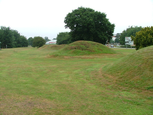
Siansean Spring, located in Hertfordshire, is a picturesque woodland area known for its stunning natural beauty. The spring is situated within a dense forest, surrounded by tall, ancient trees that create a serene and tranquil atmosphere.

The woodland is rich in biodiversity, boasting a wide variety of plant and animal species. The forest floor is covered in a lush carpet of vibrant green moss, and wildflowers bloom in abundance during the spring and summer months. The canopy above provides a cool shade and is home to numerous bird species, making it a popular spot for birdwatching enthusiasts.

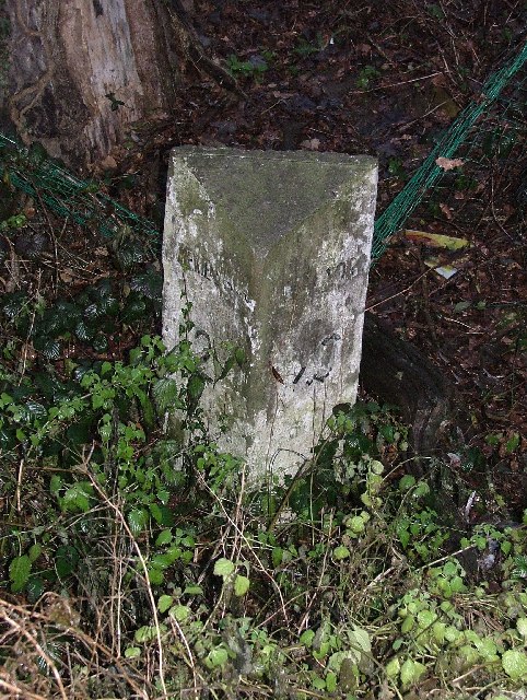
Siansean Spring gets its name from the crystal-clear spring that flows through the forest. The water is sourced from underground streams and remains cool and refreshing throughout the year. It is said to have healing properties and is often visited by those seeking solace and relaxation. The soothing sound of the water trickling over rocks adds to the peaceful ambiance of the area.

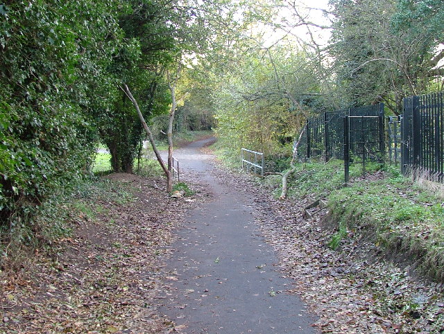
The woodland also offers a network of well-maintained walking trails, allowing visitors to explore the natural wonders at their own pace. These trails provide opportunities for hiking, jogging, or simply taking a leisurely stroll while immersing oneself in the beauty of nature.

Siansean Spring is a popular destination for nature lovers, photographers, and those looking to escape the hustle and bustle of everyday life. Whether it's a peaceful walk, a picnic by the spring, or a moment of reflection in the tranquil surroundings, Siansean Spring offers a sanctuary of natural beauty in the heart of Hertfordshire.

If you have any feedback on the listing, please let us know in the comments section below.

Siansean Spring Images

Images are sourced within 2km of 51.892407/-0.17903772 or Grid Reference TL2523. Thanks to Geograph Open Source API. All images are credited.

Hydean Way Shops Typical of local shops in Stevenage new town.  Above a parade of shops including a small supermarket, take away food outlet and Post Office there are maisonettes accessed from the rear.  To the right there are 2/3 bedroomed homes.
Hydean Way Shops
Typical of local shops in Stevenage new town. Above a parade of shops including a small supermarket, take away food outlet and Post Office there are maisonettes accessed from the rear. To the right there are 2/3 bedroomed homes.
South end of Fairlands Valley Park. This photograph was taken facing north into Fairlands Valley Park from the car park used for Stevenage Borough FC (see TL2422).  This park is also used for travelling fairs and circuses.
South end of Fairlands Valley Park.
This photograph was taken facing north into Fairlands Valley Park from the car park used for Stevenage Borough FC (see TL2422). This park is also used for travelling fairs and circuses.
Stevenage Borough FC Taken from the club's car park across the Hertford Road.
Stevenage Borough FC
Taken from the club's car park across the Hertford Road.
Novotel / Knebworth Park. Just off the A1(M) this is at the entrance of Knebworth Park home to "rock concerts through the ages".  The hotel has a helipad in its grounds.  Better access that by A1(M)
Novotel / Knebworth Park.
Just off the A1(M) this is at the entrance of Knebworth Park home to "rock concerts through the ages". The hotel has a helipad in its grounds. Better access that by A1(M)
Fairlands Valley Park This large lake is used by sailors and fishermen.  This photo is taken facing south.  To the rear there are two smaller lakes.  The park is very popular in the summer.
Fairlands Valley Park
This large lake is used by sailors and fishermen. This photo is taken facing south. To the rear there are two smaller lakes. The park is very popular in the summer.
Silam Rd. To the right are houses not untypical of Stevenage new town.  Looming over Silam Rd is one of a pair of high rise flats close to the town centre.
Silam Rd.
To the right are houses not untypical of Stevenage new town. Looming over Silam Rd is one of a pair of high rise flats close to the town centre.
Parishes Mead. Parishes mead is a newer development on the east side of Stevenage.  There is a mixture of private and social housing here.
Parishes Mead.
Parishes mead is a newer development on the east side of Stevenage. There is a mixture of private and social housing here.
Six Hills OK do you believe the OS who say that these features are tumuli or legend which says that these humps are lumps of soil thrown at travellers on the old Great North Road (just to the right of these humps but rather imposing nowadays)?  It is said that these were thrown here from Weston Woods (<a href="https://www.geograph.org.uk/gridref/TL2432">TL2432</a> and <a href="https://www.geograph.org.uk/gridref/TL2532">TL2532</a>).  Dick Turpin would have ridden past these on Black Bess on his ride from York to London.
Six Hills
OK do you believe the OS who say that these features are tumuli or legend which says that these humps are lumps of soil thrown at travellers on the old Great North Road (just to the right of these humps but rather imposing nowadays)? It is said that these were thrown here from Weston Woods (TL2432 and TL2532). Dick Turpin would have ridden past these on Black Bess on his ride from York to London.
Ferrier Rd This could be any road in this area.  Plans seem to have been bought as a job lot.
Ferrier Rd
This could be any road in this area. Plans seem to have been bought as a job lot.
Ridlins Athletics Track This photo of the Ridlins Athletics track shows the west corner and the Bert Hill stand.  The back of the stand has space for community groups such as playgroups.
Ridlins Athletics Track
This photo of the Ridlins Athletics track shows the west corner and the Bert Hill stand. The back of the stand has space for community groups such as playgroups.
Football pitches These are to the north west of the running track.
Football pitches
These are to the north west of the running track.
Footbridge over Stevenage Brook. This footpath runs parallel to and within 30 yards of the main Stevenage - Hertford Road.
Footbridge over Stevenage Brook.
This footpath runs parallel to and within 30 yards of the main Stevenage - Hertford Road.
Church of St Peter, Broadwater. One of a series of three photos taken from within a couple of hundred yards of each other.  Church shops and flats.  A whole community?
Church of St Peter, Broadwater.
One of a series of three photos taken from within a couple of hundred yards of each other. Church shops and flats. A whole community?
Flats on Broadwater Avenue Most housing in this area consists of two storey houses but there are a number of blocks of flats like this.
Flats on Broadwater Avenue
Most housing in this area consists of two storey houses but there are a number of blocks of flats like this.
Broadwater Avenue shops Very busy local shops in the same style as several other Stevenage neighbourhood centres.
Broadwater Avenue shops
Very busy local shops in the same style as several other Stevenage neighbourhood centres.
Longmeadow Evangelical Church Many of Stevenage's churche seem to thrive and this is one of them.
Longmeadow Evangelical Church
Many of Stevenage's churche seem to thrive and this is one of them.
Muddy track leading to railway bridge The track disappears under the main line into Kings Cross.  Kings Cross to the left, Grantham and the North to the right.
Muddy track leading to railway bridge
The track disappears under the main line into Kings Cross. Kings Cross to the left, Grantham and the North to the right.
Neglected milestone Well.  That will be er um miles to aaah hmm, and um er miles  to aaaaah.  Yes well it's probably a long way anyway.
Neglected milestone
Well. That will be er um miles to aaah hmm, and um er miles to aaaaah. Yes well it's probably a long way anyway.
Show me another place!

Siansean Spring is located at Grid Ref: TL2523 (Lat: 51.892407, Lng: -0.17903772)

Administrative County: Hertfordshire

District: Stevenage

Police Authority: Hertfordshire

What 3 Words

///resort.fall.asset. Near Stevenage, Hertfordshire

Related Wikis

The Heathcote School

The Heathcote School was an 11-18 comprehensive school in Stevenage, Hertfordshire. The school was founded in the 1950s. It was awarded Specialist Engineering...

Shephall

Shephall (SHEP-all) is a neighbourhood of the new town of Stevenage in Hertfordshire. It was formerly a separate village and parish, being absorbed into...

Barnwell School

Barnwell School is a coeducational secondary school and sixth form that was established in 1959 and is situated in the south of Stevenage, Hertfordshire...

Shephall Manor

Shephall Manor, also known as Shephalbury Manor, is a Grade II listed building in Stevenage, a town in Hertfordshire, England. The house was designed by...

Broadhall Way

Broadhall Way, known as the Lamex Stadium for sponsorship purposes, is an association football stadium in Stevenage, Hertfordshire. It has been the home...

Ridlins Mire

Ridlins Mire is a 1.6-hectare (4.0-acre) nature reserve managed by the Herts and Middlesex Wildlife Trust in Stevenage, Hertfordshire, England.This wetland...

Marriotts School

Marriotts School is a secondary school in Stevenage, Hertfordshire, England. The school was rebuilt along with Lonsdale School (for special needs children...

Stevenage (UK Parliament constituency)

Stevenage is a constituency in Hertfordshire represented in the House of Commons of the UK Parliament since 2010 by Stephen McPartland, a member of the...

Nearby Amenities

Located within 500m of 51.892407,-0.17903772
Pub
The Pear Tree
Source: GPS waypoint
Lat/Long: 51.8927158/-0.1837983
Mini Roundabout
Lat/Long: 51.8923941/-0.1837408
Traffic Calming: table
Lat/Long: 51.8919301/-0.1764941
Created By: osmeditor2
Lat/Long: 51.887987/-0.1802929
Created By: osmeditor2
Lat/Long: 51.8879276/-0.1785375
Bus Stop
Barnwell
Bench: no
Bin: yes
Lit: yes
Local Ref: NR
Naptan AtcoCode: 210021201380
Naptan Bearing: W
Naptan CommonName: Barnwell
Naptan Crossing: opp Wigram Way
Naptan Indicator: nr
Naptan Landmark: opp Wigram Way
Naptan NaptanCode: hrtgadgw
Naptan PlusbusZoneRef: STEVNGE
Naptan ShortCommonName: NA
Naptan Street: Hydean Way
Naptan Verified: no
Shelter: yes
Source: naptan_import
Tactile Paving: no
Lat/Long: 51.892049/-0.1734086
Bus Stop
Shephall Green
Bench: yes
Bin: yes
Lit: yes
Local Ref: NR
Naptan AtcoCode: 210021201400
Naptan Bearing: W
Naptan CommonName: Shephall Green
Naptan Crossing: opp Peartree Way
Naptan Indicator: nr
Naptan Landmark: opp Peartree Way
Naptan NaptanCode: hrtgadja
Naptan PlusbusZoneRef: STEVNGE
Naptan ShortCommonName: NA
Naptan Street: Hydean Way
Naptan Verified: no
Shelter: yes
Source: naptan_import
Tactile Paving: yes
Lat/Long: 51.8917106/-0.1800059
Bus Stop
Peartree Centre
Bench: yes
Bin: yes
Lit: yes
Naptan AtcoCode: 210021201420
Naptan Bearing: NE
Naptan CommonName: Peartree Centre
Naptan Crossing: Shackleton Spring
Naptan Indicator: opp
Naptan Landmark: Shackleton Spring
Naptan NaptanCode: hrtgadjd
Naptan PlusbusZoneRef: STEVNGE
Naptan ShortCommonName: NA
Naptan Street: Valley Way
Naptan Verified: no
Shelter: yes
Source: naptan_import
Lat/Long: 51.8928749/-0.1834234
Bus Stop
Peartree Way
Bench: yes
Bin: yes
Lit: yes
Naptan AtcoCode: 210021201440
Naptan Bearing: NE
Naptan CommonName: Peartree Way
Naptan Crossing: Fairlands Valley Park
Naptan Indicator: opp
Naptan Landmark: Fairlands Valley Park
Naptan NaptanCode: hrtgadjg
Naptan PlusbusZoneRef: STEVNGE
Naptan ShortCommonName: NA
Naptan Street: Valley Way
Naptan Verified: no
Shelter: yes
Source: naptan_import
Tactile Paving: no
Wheelchair: yes
Lat/Long: 51.8958606/-0.1814661
Bus Stop
School Close
Bench: no
Bin: no
Bus: yes
Lit: yes
Local Ref: NR
Naptan AtcoCode: 210021201465
Naptan Bearing: N
Naptan CommonName: School Close
Naptan Crossing: Peartree Park
Naptan Indicator: nr
Naptan Landmark: Peartree Park
Naptan NaptanCode: hrtgadjp
Naptan PlusbusZoneRef: STEVNGE
Naptan ShortCommonName: NA
Naptan Street: Paddocks Close
Naptan Verified: no
Public Transport: platform
Shelter: no
Source: naptan_import
Tactile Paving: no
Lat/Long: 51.8948023/-0.1746777
Bus Stop
Peartree Way
Bench: no
Bin: no
Lit: yes
Naptan AtcoCode: 210021203220
Naptan Bearing: SW
Naptan CommonName: Peartree Way
Naptan Crossing: Peartree Way
Naptan Indicator: adj
Naptan Landmark: Peartree Way
Naptan NaptanCode: hrtdwmam
Naptan PlusbusZoneRef: STEVNGE
Naptan ShortCommonName: NA
Naptan Street: Valley Way
Naptan Verified: no
Shelter: no
Source: naptan_import
Tactile Paving: yes
Wheelchair: yes
Lat/Long: 51.8953497/-0.1815739
Bus Stop
Peartree Centre
Bench: yes
Bin: no
Lit: yes
Naptan AtcoCode: 210021203240
Naptan Bearing: SE
Naptan CommonName: Peartree Centre
Naptan Crossing: Peartree Centre
Naptan Indicator: adj
Naptan Landmark: Peartree Centre
Naptan NaptanCode: hrtdwmap
Naptan PlusbusZoneRef: STEVNGE
Naptan ShortCommonName: NA
Naptan Street: Hydean Way
Naptan Verified: no
Shelter: yes
Source: naptan_import
Tactile Paving: no
Lat/Long: 51.8923192/-0.1833095
Bus Stop
Shephall Green
Bench: yes
Bin: yes
Lit: yes
Naptan AtcoCode: 210021203260
Naptan Bearing: E
Naptan CommonName: Shephall Green
Naptan Crossing: Peatree Way
Naptan Indicator: opp
Naptan Landmark: Peatree Way
Naptan NaptanCode: hrtdwmat
Naptan PlusbusZoneRef: STEVNGE
Naptan ShortCommonName: NA
Naptan Street: Hydean Way
Naptan Verified: no
Shelter: yes
Source: naptan_import
Tactile Paving: yes
Lat/Long: 51.8918222/-0.1781865
Bus Stop
Barnwell
Bench: yes
Bin: yes
Lit: yes
Naptan AtcoCode: 210021203280
Naptan Bearing: E
Naptan CommonName: Barnwell
Naptan Crossing: Wigram Way
Naptan Indicator: opp
Naptan Landmark: Wigram Way
Naptan NaptanCode: hrtdwmaw
Naptan PlusbusZoneRef: STEVNGE
Naptan ShortCommonName: NA
Naptan Street: Hydean Way
Naptan Verified: no
Shelter: yes
Source: naptan_import
Tactile Paving: no
Lat/Long: 51.8921882/-0.1719496
Bus Stop
Wigram Way
Bench: no
Bin: no
Bus: yes
Lit: yes
Naptan AtcoCode: 210021204625
Naptan Bearing: W
Naptan CommonName: Wigram Way
Naptan Crossing: Bradshaw Court
Naptan Indicator: W-bound
Naptan Landmark: Bradshaw Court
Naptan NaptanCode: hrtdwgpd
Naptan PlusbusZoneRef: STEVNGE
Naptan ShortCommonName: NA
Naptan Street: The Paddocks
Naptan Verified: no
Public Transport: platform
Shelter: no
Source: naptan_import
Tactile Paving: no
Lat/Long: 51.8938015/-0.1721894
Bus Stop
Hyde Green North
Bench: no
Bin: no
Bus: yes
Lit: yes
Naptan AtcoCode: 210021204630
Naptan Bearing: NW
Naptan CommonName: Hyde Green North
Naptan Crossing: School Close
Naptan Indicator: W-bound
Naptan Landmark: School Close
Naptan NaptanCode: hrtdwgpg
Naptan PlusbusZoneRef: STEVNGE
Naptan ShortCommonName: NA
Naptan Street: The Paddocks
Naptan Verified: no
Public Transport: platform
Shelter: no
Source: naptan_import
Tactile Paving: no
Lat/Long: 51.8938618/-0.1737566
Barrier: bollard
Lat/Long: 51.8932123/-0.1738296
Barrier: bollard
Lat/Long: 51.8945362/-0.1735471
Post Box
Collection Times: Mo-Fr 09:00, Sa 07:00
Post Box Type: lamp
Ref: SG2 112
Lat/Long: 51.890331/-0.176736
Post Box
Collection Times: Mo-Fr 18:45; Sa 12:00
Post Box Design: type_k
Post Box Type: pillar
Ref: SG2 297
Lat/Long: 51.8924873/-0.1832872
Post Box
Collection Times: Mo-Fr 09:00, Sa 07:00
Post Box Type: pillar
Ref: SG2 292
Royal Cypher: EIIR
Royal Cypher Wikidata: Q33102113
Lat/Long: 51.889004/-0.183117
Post Box
Collection Times: Mo-Fr 09:00; Sa 07:00
Post Box Type: pillar
Ref: SG2 303
Royal Cypher: EIIR
Royal Cypher Wikidata: Q33102113
Lat/Long: 51.895241/-0.180067
Post Box
Collection Times: Mo-Fr 09:00; Sa 07:00
Post Box Type: pillar
Ref: SG2 312
Lat/Long: 51.895138/-0.174738
Atm
Fee: no
Operator: The Co-operative Bank
Lat/Long: 51.8925835/-0.1833049
Traffic Calming: table
Lat/Long: 51.8917926/-0.1774093
Bench
Backrest: yes
Lat/Long: 51.8955858/-0.1770169
Crossing
Crossing: marked
Crossing Island: no
Crossing Ref: zebra
Kerb: lowered
Tactile Paving: yes
Traffic Calming: table
Lat/Long: 51.891765/-0.1787066
Bench
Backrest: yes
Lat/Long: 51.8956115/-0.1765539
Crossing
Crossing: unmarked
Crossing Island: yes
Tactile Paving: yes
Lat/Long: 51.892628/-0.1835256
Crossing
Crossing: marked
Crossing Island: no
Kerb: flush
Tactile Paving: yes
Traffic Calming: table
Lat/Long: 51.8920425/-0.1754364
Waste Basket
Lat/Long: 51.8880211/-0.1782757
Waste Basket
Lat/Long: 51.8905406/-0.185346
Waste Basket
Lat/Long: 51.8923375/-0.1838815
Waste Basket
Lat/Long: 51.8923979/-0.1834068
Waste Basket
Lat/Long: 51.8928423/-0.1834537
Waste Basket
Lat/Long: 51.8956347/-0.1812878
Waste Basket
Lat/Long: 51.8957572/-0.1815011
Crossing
Crossing: unmarked
Crossing Island: yes
Kerb: lowered
Tactile Paving: yes
Lat/Long: 51.8922575/-0.1838757
Crossing
Crossing: unmarked
Crossing Island: yes
Kerb: lowered
Tactile Paving: no
Lat/Long: 51.892351/-0.1836138
Waste Basket
Lat/Long: 51.8919361/-0.1823795
Waste Basket
Lat/Long: 51.8917101/-0.1799628
Waste Basket
Lat/Long: 51.891821/-0.178104
Traffic Calming: cushion
Lat/Long: 51.8917556/-0.1790978
Waste Basket
Lat/Long: 51.8918997/-0.1769775
Waste Basket
Lat/Long: 51.89209/-0.1755184
Traffic Calming: table
Lat/Long: 51.8920706/-0.1744802
Traffic Calming: table
Lat/Long: 51.8920926/-0.1737083
Waste Basket
Lat/Long: 51.8920495/-0.1734437
Crossing
Crossing: unmarked
Crossing Island: no
Kerb: flush
Tactile Paving: yes
Traffic Calming: table
Lat/Long: 51.8921332/-0.1725495
Waste Basket
Lat/Long: 51.8921885/-0.1718666
Bus Stop
Hydean Road
Bench: no
Bin: no
Bus: yes
Lit: yes
Naptan AtcoCode: 210021204620
Naptan NaptanCode: hrtgtdjt
Public Transport: platform
Shelter: no
Tactile Paving: no
Lat/Long: 51.8926603/-0.172277
Waste Basket
Lat/Long: 51.892849/-0.1718692
Waste Basket
Lat/Long: 51.8938744/-0.1733767
Waste Basket
Lat/Long: 51.8941326/-0.1743785
Waste Basket
Lat/Long: 51.8955847/-0.1770432
Air Training Corps 955 (Stevenage) Squadron
Club: youth_movement
Lat/Long: 51.8916836/-0.1835342
Shackleton Springs
Board Type: nature
Information: board
Tourism: information
Lat/Long: 51.8919034/-0.1848874
Barrier: bollard
Lat/Long: 51.8907293/-0.1841041
Bench
Backrest: yes
Colour: black
Material: metal
Lat/Long: 51.8899927/-0.1766087
Bench
Backrest: yes
Colour: black
Material: metal
Lat/Long: 51.8905009/-0.1767522
Barrier: bollard
Lat/Long: 51.8902766/-0.176105
Barrier: bollard
Lat/Long: 51.8902283/-0.1761109
The data included in this document is from www.openstreetmap.org. The data is made available under ODbL.

Have you been to Siansean Spring?

Leave your review of Siansean Spring below (or comments, questions and feedback).