Addlestead Wood

Wood, Forest in Surrey Mole Valley

England

Addlestead Wood

Ralliwood Road Residential estate with private roads and public footpaths. The Thames Down Link national trail passes the north end of this road. The 15 mile trail links the Thames path national trail to the North Downs Way national path.
Ralliwood Road Credit: James Emmans

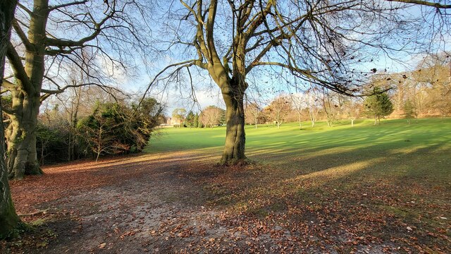
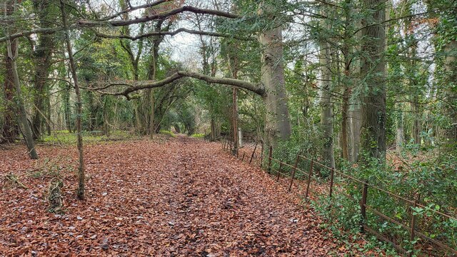
Addlestead Wood is a picturesque woodland located in the county of Surrey, England. Covering an area of approximately 100 acres, this enchanting forest is nestled within the countryside, offering a tranquil escape from the bustling city life.

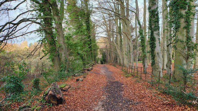
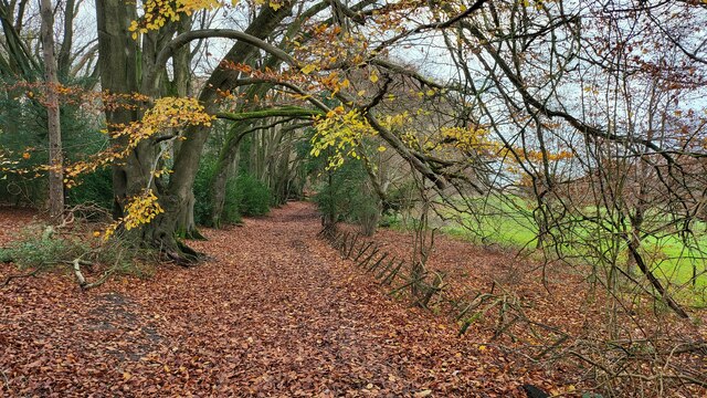
The wood is characterized by its diverse range of tree species, including oak, beech, and ash, which create a vibrant canopy that changes with the seasons. The forest floor is adorned with a rich carpet of bluebells in the spring, further enhancing the beauty of the landscape.

Addlestead Wood boasts a network of well-maintained footpaths, making it a popular destination for nature enthusiasts and walkers alike. These paths meander through the woodland, allowing visitors to explore its hidden nooks and crannies. Along the way, one may encounter various wildlife species, such as deer, squirrels, and a plethora of bird species, making it a paradise for birdwatchers.

The wood is managed by a local conservation organization, which ensures the preservation of its natural beauty and biodiversity. This includes regular maintenance and monitoring of the forest's health, as well as initiatives to protect and encourage the growth of native flora and fauna.

Addlestead Wood offers a peaceful retreat for individuals seeking solace in nature. Its serene ambiance, stunning vistas, and abundance of wildlife make it a haven for relaxation and exploration. Whether one wishes to take a leisurely stroll, indulge in birdwatching, or simply enjoy a picnic amidst the tranquility of the forest, Addlestead Wood is a destination that promises to leave visitors rejuvenated and connected with the natural world.

If you have any feedback on the listing, please let us know in the comments section below.

Addlestead Wood Images

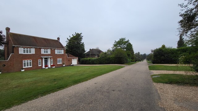
Images are sourced within 2km of 51.293402/-0.28401721 or Grid Reference TQ1956. Thanks to Geograph Open Source API. All images are credited.

Ralliwood Road Residential estate with private roads and public footpaths. The Thames Down Link national trail passes the north end of this road. The 15 mile trail links the Thames path national trail to the North Downs Way national path.
Ralliwood Road
Residential estate with private roads and public footpaths. The Thames Down Link national trail passes the north end of this road. The 15 mile trail links the Thames path national trail to the North Downs Way national path.
Tyrrell's Wood Golf Club The club house is in the distance.
Tyrrell's Wood Golf Club
The club house is in the distance.
Stane Street Route of a Roman Road now used as a bridleway and the Thames Downs Link trail. The official link for the Thames Path and the North Downs Way.
Stane Street
Route of a Roman Road now used as a bridleway and the Thames Downs Link trail. The official link for the Thames Path and the North Downs Way.
Bridleway on the northern edge of Cherkley Woods Beech leaves forming a thick carpet.

The path is near the car park on Mill Way.
Bridleway on the northern edge of Cherkley Woods
Beech leaves forming a thick carpet. The path is near the car park on Mill Way.
Bridleway towards Downside Manor A very old metal fence on its last legs, marks the boundary of the Tyrrell's Wood Golf Club. 

Info - <span class="nowrap"><a title="https://www.tyrrellswoodgolfclub.com/" rel="nofollow ugc noopener" href="https://www.tyrrellswoodgolfclub.com/">Link</a><img style="margin-left:2px;" alt="External link" title="External link - shift click to open in new window" src="https://s1.geograph.org.uk/img/external.png" width="10" height="10"/></span>
Bridleway towards Downside Manor
A very old metal fence on its last legs, marks the boundary of the Tyrrell's Wood Golf Club. Info - LinkExternal link
M25 clockwise - farm accommodation bridge
Witness Oak sculpture by sculptor John Merrill at Langley Vale Wood, the largest of four First World War Centenary woods developed by the Woodland Trust.  Inscribed inside it are extracts from 7 poems by World War I poets.  In the background is one of the statues forming part of Patrick Wall's Regiment of Trees.
Witness
Oak sculpture by sculptor John Merrill at Langley Vale Wood, the largest of four First World War Centenary woods developed by the Woodland Trust. Inscribed inside it are extracts from 7 poems by World War I poets. In the background is one of the statues forming part of Patrick Wall's Regiment of Trees.
Witness Oak sculpture by sculptor John Merrill at Langley Vale Wood, the largest of four First World War centenary woods developed by the Woodland Trust.  Inscribed inside it are extracts from 7 poems by World War I poets.
Witness
Oak sculpture by sculptor John Merrill at Langley Vale Wood, the largest of four First World War centenary woods developed by the Woodland Trust. Inscribed inside it are extracts from 7 poems by World War I poets.
The Regiment of Trees A group of 12 statues by Patrick Wall in Langley Vale Wood, the largest of four First World War centenary woods developed by the Woodland Trust.  The artwork commemorates the inspection of troops on Epsom Downs  by Lord Kitchener in January 1915.  In the background is John Merrill's sculpture Witness (see <a href="https://www.geograph.org.uk/photo/6945200">TQ2057 : Witness</a>).
The Regiment of Trees
A group of 12 statues by Patrick Wall in Langley Vale Wood, the largest of four First World War centenary woods developed by the Woodland Trust. The artwork commemorates the inspection of troops on Epsom Downs by Lord Kitchener in January 1915. In the background is John Merrill's sculpture Witness (see TQ2057 : Witness).
The Regiment of Trees One of a group of 12 statues by Patrick Wall in Langley Vale Wood, the largest of four First World War centenary woods developed by the Woodland Trust.  The artwork commemorates the inspection of troops on Epsom Downs by Lord Kitchener in January 1915.  In the background is John Merrill's sculpture Witness (see <a href="https://www.geograph.org.uk/photo/6945200">TQ2057 : Witness</a>).
The Regiment of Trees
One of a group of 12 statues by Patrick Wall in Langley Vale Wood, the largest of four First World War centenary woods developed by the Woodland Trust. The artwork commemorates the inspection of troops on Epsom Downs by Lord Kitchener in January 1915. In the background is John Merrill's sculpture Witness (see TQ2057 : Witness).
Jutland Wood Area in Langley Vale Wood, the largest of four First World War centenary woods developed by the Woodland Trust.  Each of the 14 boards created by Andrew Lapthorn commemorates a ship lost in the Battle of Jutland in 2016, listing the numbers from each drowned or surviving.
Jutland Wood
Area in Langley Vale Wood, the largest of four First World War centenary woods developed by the Woodland Trust. Each of the 14 boards created by Andrew Lapthorn commemorates a ship lost in the Battle of Jutland in 2016, listing the numbers from each drowned or surviving.
Jutland Wood Area in Langley Vale Wood, the largest of four First World War centenary woods developed by the Woodland Trust.  Each of the 14 boards created by Andrew Lapthorn commemorates a ship lost in the Battle of Jutland in 1916, listing the numbers from each drowned or surviving.
Jutland Wood
Area in Langley Vale Wood, the largest of four First World War centenary woods developed by the Woodland Trust. Each of the 14 boards created by Andrew Lapthorn commemorates a ship lost in the Battle of Jutland in 1916, listing the numbers from each drowned or surviving.
Jutland Wood A seat and figure in Jutland Wood, an area in Langley Vale Wood, the largest of four First World War centenary woods developed by the Woodland Trust.  The seat is by Andrew Lapthorn and the figure is by Christine Charlesworth. 
Jutland Wood commemorates the Battle of Jutland in 1916, and the figure has two sides - the far side looking towards the original woodland in the background, which would have been in existence at the time of the battle, depicts a sailor in 1916 uniform, while the side seen here, looking towards the future woodland and depicts a sailor in 2016 uniform.
Jutland Wood
A seat and figure in Jutland Wood, an area in Langley Vale Wood, the largest of four First World War centenary woods developed by the Woodland Trust. The seat is by Andrew Lapthorn and the figure is by Christine Charlesworth. Jutland Wood commemorates the Battle of Jutland in 1916, and the figure has two sides - the far side looking towards the original woodland in the background, which would have been in existence at the time of the battle, depicts a sailor in 1916 uniform, while the side seen here, looking towards the future woodland and depicts a sailor in 2016 uniform.
Langley Vale Wood A section of Langley Vale Wood, the largest of four First World War centenary woods developed by the Woodland Trust, with the Queen's Stand and Duchess's Stand of Epsom Downs Racecourse in the background.
Langley Vale Wood
A section of Langley Vale Wood, the largest of four First World War centenary woods developed by the Woodland Trust, with the Queen's Stand and Duchess's Stand of Epsom Downs Racecourse in the background.
Langley Vale Wood A section of Langley Vale Wood, the largest of four First World War centenary woods developed by the Woodland Trust, with distant views of Tolworth Tower, Wembley Stadium and One West Point in Acton.
Langley Vale Wood
A section of Langley Vale Wood, the largest of four First World War centenary woods developed by the Woodland Trust, with distant views of Tolworth Tower, Wembley Stadium and One West Point in Acton.
M25 clockwise
M25 clockwise
Show me another place!

Addlestead Wood is located at Grid Ref: TQ1956 (Lat: 51.293402, Lng: -0.28401721)

Administrative County: Surrey

District: Mole Valley

Police Authority: Surrey

What 3 Words

///likely.dined.spaces. Near Ashtead, Surrey

Nearby Locations

Addlestead Wood

Related Wikis

Headley Court

Defence Medical Rehabilitation Centre Headley Court (abbreviated to DMRC Headley Court, and more commonly known as Headley Court), formerly RAF Headley...

City of London Freemen's School

City of London Freemen's School (CLFS) is a co-educational private school for day and boarding pupils, located at Ashtead Park in Surrey, England. It is...

Langley Vale Wood

Langley Vale Wood is one of four First World War Centenary woods created by the Woodland Trust. It is located in Langley Vale, near Epsom, on the North...

Epsom Down

Epsom Down in the southern town outlands of Epsom was used as a venue for two first-class cricket matches between 1816 and 1819. Both were between the...

Nearby Amenities

Located within 500m of 51.293402,-0.28401721
Phone
Emergency: phone
Operator: National Highways
Operator Wikidata: Q5760006
Lat/Long: 51.2912654/-0.2846274
Phone
Emergency: phone
Operator: National Highways
Operator Wikidata: Q5760006
Lat/Long: 51.2915848/-0.2841887
Phone
Emergency: phone
Operator: National Highways
Operator Wikidata: Q5760006
Lat/Long: 51.2924791/-0.2893467
Phone
Emergency: phone
Operator: National Highways
Operator Wikidata: Q5760006
Lat/Long: 51.2921172/-0.2895977
Man Made: tower
Tower Type: communication
Lat/Long: 51.2919527/-0.2848591
Traffic Sign: variable_message
Variable Message Model: AMI
Lat/Long: 51.2909276/-0.2817346
Traffic Sign: variable_message
Variable Message Model: AMI
Lat/Long: 51.2909024/-0.2817511
Traffic Sign: variable_message
Variable Message Model: AMI
Lat/Long: 51.2908653/-0.2817754
Traffic Sign: variable_message
Variable Message Model: AMI
Lat/Long: 51.2908356/-0.2817949
Traffic Sign: variable_message
Variable Message Model: AMI
Lat/Long: 51.2906798/-0.281897
Traffic Sign: variable_message
Variable Message Model: AMI
Lat/Long: 51.2907085/-0.2818781
Traffic Sign: variable_message
Variable Message Model: AMI
Lat/Long: 51.2907456/-0.2818538
Traffic Sign: variable_message
Variable Message Model: AMI
Lat/Long: 51.2907734/-0.2818356
Camera Mount: pole
Camera Type: panning
Man Made: surveillance
Operator: National Highways
Operator Wikidata: Q5760006
Surveillance: outdoor
Surveillance Type: camera
Surveillance Zone: traffic
Lat/Long: 51.2908061/-0.2818142
Traffic Sign: variable_message
Variable Message Model: MS2
Lat/Long: 51.2909881/-0.281695
Traffic Sign: variable_message
Variable Message Model: MS2
Lat/Long: 51.2906237/-0.2819337
The data included in this document is from www.openstreetmap.org. The data is made available under ODbL.

Have you been to Addlestead Wood?

Leave your review of Addlestead Wood below (or comments, questions and feedback).