Bushy Copse

Wood, Forest in Sussex Horsham

England

Bushy Copse

Looking west on Pound Lane
Looking west on Pound Lane Credit: Shazz

Bushy Copse is a beautiful woodland located in Sussex, England. Covering an area of approximately 100 acres, it is a significant part of the local landscape and an important natural habitat. The copse is nestled in the heart of the Sussex countryside, surrounded by rolling hills and picturesque farmland.

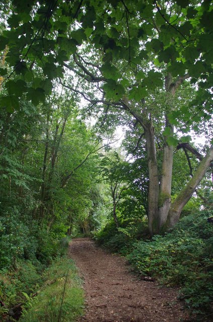
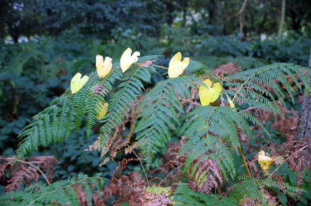
The woodland is primarily composed of a variety of native trees such as oak, beech, and ash, creating a dense canopy that provides shelter and food for a wide range of wildlife. The forest floor is carpeted with a diverse array of wildflowers and ferns, adding to the copse's natural beauty.

Bushy Copse offers a peaceful and tranquil environment, making it a popular destination for nature lovers, hikers, and birdwatchers. The copse is home to a rich assortment of bird species, including woodpeckers, nightingales, and warblers. Visitors may also catch a glimpse of elusive mammals such as deer, foxes, and badgers.

The woodland is crisscrossed by a network of well-maintained trails, allowing visitors to explore its various nooks and crannies. These paths lead to charming clearings, babbling brooks, and hidden ponds, providing an opportunity to observe the copse's diverse flora and fauna up close.

Bushy Copse is not only a haven for wildlife but also serves as an important carbon sink, contributing to the region's efforts to combat climate change. The copse is managed sustainably, with conservation practices in place to ensure its long-term preservation.

Overall, Bushy Copse is a treasured natural gem in Sussex, offering a peaceful retreat and a chance to immerse oneself in the wonders of the British countryside.

If you have any feedback on the listing, please let us know in the comments section below.

Bushy Copse Images

Images are sourced within 2km of 51.038711/-0.29538305 or Grid Reference TQ1927. Thanks to Geograph Open Source API. All images are credited.

Looking west on Pound Lane
Looking east on Pound Lane
Signpost at western end of Winterpit Lane A different view is at <a title="https://www.geograph.org.uk/photo/1864181" href="https://www.geograph.org.uk/photo/1864181">Link</a>.
Signpost at western end of Winterpit Lane
A different view is at Link.
Seat on grassy area in Mannings Heath
Junction of Brighton and Church Roads A different view is at <a title="https://www.geograph.org.uk/photo/4232077" href="https://www.geograph.org.uk/photo/4232077">Link</a>.
Junction of Brighton and Church Roads
A different view is at Link.
Cottages on the A281 in Mannings Heath "The Dun Horse" PH beyond the dwellings is all boarded up.
See also <a title="https://www.geograph.org.uk/photo/1864075" href="https://www.geograph.org.uk/photo/1864075">Link</a>.
Cottages on the A281 in Mannings Heath
"The Dun Horse" PH beyond the dwellings is all boarded up. See also Link.
Bridleway to Old Camp Farm Mannings Heath Hotel Golf Course is to the left behind the trees.
Bridleway to Old Camp Farm
Mannings Heath Hotel Golf Course is to the left behind the trees.
The Gallop A well used bridlepath.
The Gallop
A well used bridlepath.
Old Oaks by the Gallop These Oaks don't quite qualify as "ancient" but I am sure the last woodsman to pollard them does not get headaches anymore!
Old Oaks by the Gallop
These Oaks don't quite qualify as "ancient" but I am sure the last woodsman to pollard them does not get headaches anymore!
Fern by the Gallop I could see the bindweed leaves a hundred yards away it was not until I was within a few yards I could actually work out what I was looking at.
Fern by the Gallop
I could see the bindweed leaves a hundred yards away it was not until I was within a few yards I could actually work out what I was looking at.
Deer Fence by the Gallop A little further on I discovered why the landowner needs deer fences see <a href="https://www.geograph.org.uk/photo/5145962">TQ2027 : Venison on the Hoof</a>
Deer Fence by the Gallop
A little further on I discovered why the landowner needs deer fences see TQ2027 : Venison on the Hoof
Venison on the Hoof Farmed deer near Monk's Gate.
Venison on the Hoof
Farmed deer near Monk's Gate.
Gates by Old Camp Farm I think this bridleway is called <a href="https://www.geograph.org.uk/photo/5145940">TQ2127 : The Gallop</a> the gate to the right was impounding <a href="https://www.geograph.org.uk/photo/5145962">TQ2027 : Venison on the Hoof</a>
Gates by Old Camp Farm
I think this bridleway is called TQ2127 : The Gallop the gate to the right was impounding TQ2027 : Venison on the Hoof
Newell's Pond Technically it is a lake as it has an inlet stream and an outflow.
Newell's Pond
Technically it is a lake as it has an inlet stream and an outflow.
Newell's Pond Near Monks Gate A lake with private fishing rights.
Newell's Pond Near Monks Gate
A lake with private fishing rights.
Pond at Newell's Farm This one is a pond unlike <a href="https://www.geograph.org.uk/photo/5146206">TQ2027 : Newell's Pond</a> which is a lake.
Pond at Newell's Farm
This one is a pond unlike TQ2027 : Newell's Pond which is a lake.
Footpath to Spring Wood The green path across the stubble is an <a href="https://www.geograph.org.uk/photo/5146243">TQ2026 : Airstrip</a>
Footpath to Spring Wood
The green path across the stubble is an TQ2026 : Airstrip
Airstrip Looking across the <a href="https://www.geograph.org.uk/photo/5146245">TQ2026 : Grass Runway</a> of an airstrip near Newell's Farm. I assume it is used for microlights as it is rather short for normal light aircraft. The footpath to Newell's Lane passes to the right of the hedge.
Airstrip
Looking across the TQ2026 : Grass Runway of an airstrip near Newell's Farm. I assume it is used for microlights as it is rather short for normal light aircraft. The footpath to Newell's Lane passes to the right of the hedge.
Show me another place!

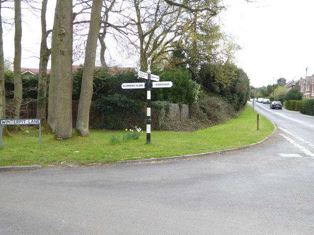
Bushy Copse is located at Grid Ref: TQ1927 (Lat: 51.038711, Lng: -0.29538305)

Administrative County: West Sussex

District: Horsham

Police Authority: Sussex

What 3 Words

///catchers.celebrate.storyline. Near Horsham, West Sussex

Related Wikis

Monk's Gate

Monk's Gate is a hamlet in the civil parish of Nuthurst, in the Horsham District of West Sussex, England. It lies on the A281 road 3 miles (5 km) southeast...

Southwater & Nuthurst (electoral division)

Southwater & Nuthurst is an electoral division of West Sussex in the United Kingdom and returns one member to sit on West Sussex County Council. The current...

Mannings Heath

Mannings Heath is a village in the civil parish of Nuthurst and the Horsham District of West Sussex, England. The village is on the A281 road, 2 miles...

Nuthurst

Nuthurst is a village and civil parish in the Horsham district of West Sussex, England. The north of the parish borders Horsham town, with Nuthurst village...

Nearby Amenities

Located within 500m of 51.038711,-0.29538305
Barrier: stile
Lat/Long: 51.037514/-0.289737
Power: tower
Lat/Long: 51.0419201/-0.2957207
Power: tower
Lat/Long: 51.03941/-0.296241
Power: tower
Lat/Long: 51.0366152/-0.2968453
Barrier: stile
Lat/Long: 51.0375531/-0.2897308
Whytings Farm
Place: farm
Lat/Long: 51.0419837/-0.2995414
The data included in this document is from www.openstreetmap.org. The data is made available under ODbL.

Have you been to Bushy Copse?

Leave your review of Bushy Copse below (or comments, questions and feedback).