Thorpe Wood

Wood, Forest in Northamptonshire

England

Thorpe Wood

Longthorpe Tower House <span class="nowrap"><a title="https://historicengland.org.uk/listing/the-list/list-entry/1162040?section=official-listing" rel="nofollow ugc noopener" href="https://historicengland.org.uk/listing/the-list/list-entry/1162040?section=official-listing">Link</a><img style="margin-left:2px;" alt="External link" title="External link - shift click to open in new window" src="https://s1.geograph.org.uk/img/external.png" width="10" height="10"/></span>
Longthorpe Tower House Credit: Sandy Gerrard

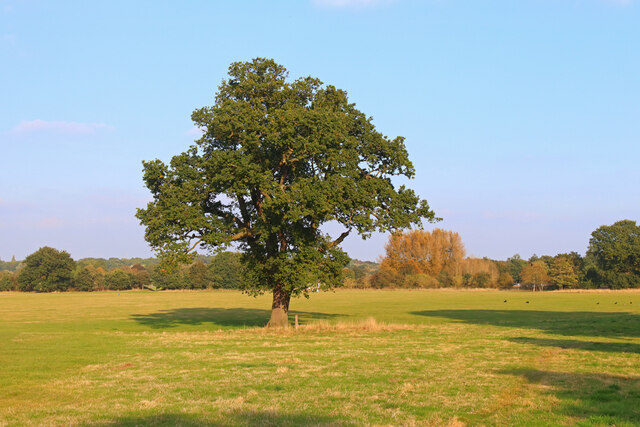
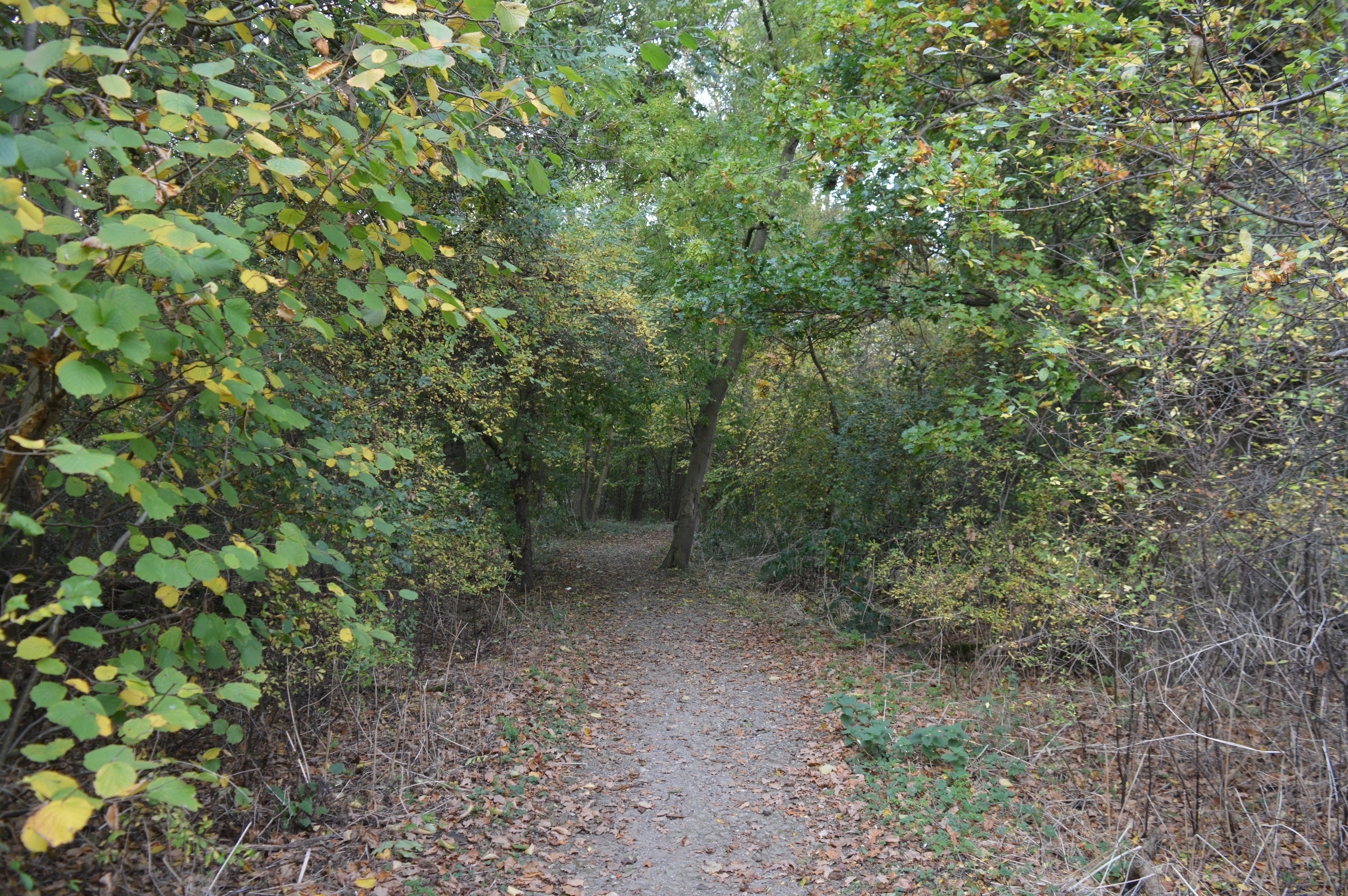
Thorpe Wood is a small woodland area located in Northamptonshire, England. It is situated near the village of Thorpe Malsor and covers an approximate area of 10 acres. The wood is part of the larger Rockingham Forest, a historic royal hunting forest.

Thorpe Wood is predominantly made up of broadleaf trees such as oak, ash, and beech, which provide a diverse and vibrant habitat for various wildlife species. The wood is also home to a variety of bird species, including woodpeckers, owls, and songbirds. It is a popular destination for birdwatchers and nature enthusiasts.

The woodland has a network of footpaths and trails, making it accessible for walkers and hikers. The paths wind through the trees, offering visitors a peaceful and tranquil environment to enjoy the natural surroundings. In spring, the woodland floor is carpeted with bluebells, creating a stunning display of color.

In addition to its natural beauty, Thorpe Wood also has historical significance. The wood was once part of the ancient Rockingham Forest, which was a royal hunting ground during the medieval period. The forest played a crucial role in providing game for the royal court and was managed by forest officials known as Verderers.

Today, Thorpe Wood is managed by the Forestry Commission, which ensures its conservation and protection for future generations to enjoy. It serves as a valuable green space and an important habitat for wildlife in the Northamptonshire area.

If you have any feedback on the listing, please let us know in the comments section below.

Thorpe Wood Images

Images are sourced within 2km of 52.571605/-0.29254363 or Grid Reference TL1598. Thanks to Geograph Open Source API. All images are credited.

Longthorpe Tower House <span class="nowrap"><a title="https://historicengland.org.uk/listing/the-list/list-entry/1162040?section=official-listing" rel="nofollow ugc noopener" href="https://historicengland.org.uk/listing/the-list/list-entry/1162040?section=official-listing">Link</a><img style="margin-left:2px;" alt="External link" title="External link - shift click to open in new window" src="https://s1.geograph.org.uk/img/external.png" width="10" height="10"/></span>
Longthorpe Tower House
Longthorpe buildings [1] Longthorpe Post Office, number 293 Thorpe Road, was built in the 18th century. Constructed of plastered rubble stone under a thatch roof. There is a small shop extension on the right. Listed, grade II, with details at: <span class="nowrap"><a title="https://historicengland.org.uk/listing/the-list/list-entry/1126916" rel="nofollow ugc noopener" href="https://historicengland.org.uk/listing/the-list/list-entry/1126916">Link</a><img style="margin-left:2px;" alt="External link" title="External link - shift click to open in new window" src="https://s1.geograph.org.uk/img/external.png" width="10" height="10"/></span>
Longthorpe is a village in the city of Peterborough, some 2 miles west of the city centre. A Roman fort was established here in the 1st century covering 27 acres, later replaced by another fort of 11 acres. The village is home to Longthorpe Tower, a 14th-century tower and fortified manor house, it contains the finest and most complete set of domestic paintings of the period in northern Europe.
Longthorpe buildings [1]
Longthorpe Post Office, number 293 Thorpe Road, was built in the 18th century. Constructed of plastered rubble stone under a thatch roof. There is a small shop extension on the right. Listed, grade II, with details at: LinkExternal link Longthorpe is a village in the city of Peterborough, some 2 miles west of the city centre. A Roman fort was established here in the 1st century covering 27 acres, later replaced by another fort of 11 acres. The village is home to Longthorpe Tower, a 14th-century tower and fortified manor house, it contains the finest and most complete set of domestic paintings of the period in northern Europe.
Longthorpe houses [1] Originally three cottages, now two houses, numbers 307 and 309 Thorpe Road, are 18th century cottages with part of one wing from the 17th century. Constructed of coursed rubble stone under a thatch roof. Listed, grade II, with details at: <span class="nowrap"><a title="https://historicengland.org.uk/listing/the-list/list-entry/1309842" rel="nofollow ugc noopener" href="https://historicengland.org.uk/listing/the-list/list-entry/1309842">Link</a><img style="margin-left:2px;" alt="External link" title="External link - shift click to open in new window" src="https://s1.geograph.org.uk/img/external.png" width="10" height="10"/></span>
Longthorpe is a village in the city of Peterborough, some 2 miles west of the city centre. A Roman fort was established here in the 1st century covering 27 acres, later replaced by another fort of 11 acres. The village is home to Longthorpe Tower, a 14th-century tower and fortified manor house, it contains the finest and most complete set of domestic paintings of the period in northern Europe.
Longthorpe houses [1]
Originally three cottages, now two houses, numbers 307 and 309 Thorpe Road, are 18th century cottages with part of one wing from the 17th century. Constructed of coursed rubble stone under a thatch roof. Listed, grade II, with details at: LinkExternal link Longthorpe is a village in the city of Peterborough, some 2 miles west of the city centre. A Roman fort was established here in the 1st century covering 27 acres, later replaced by another fort of 11 acres. The village is home to Longthorpe Tower, a 14th-century tower and fortified manor house, it contains the finest and most complete set of domestic paintings of the period in northern Europe.
Longthorpe houses [2] Foxgloves, number 310 Thorpe Road, is one house created from three 18th century cottages. Constructed of rendered rubble stone under a thatch roof. Listed, grade II, <span class="nowrap"><a title="https://historicengland.org.uk/listing/the-list/list-entry/1126920" rel="nofollow ugc noopener" href="https://historicengland.org.uk/listing/the-list/list-entry/1126920">Link</a><img style="margin-left:2px;" alt="External link" title="External link - shift click to open in new window" src="https://s1.geograph.org.uk/img/external.png" width="10" height="10"/></span>
Longthorpe is a village in the city of Peterborough, some 2 miles west of the city centre. A Roman fort was established here in the 1st century covering 27 acres, later replaced by another fort of 11 acres. The village is home to Longthorpe Tower, a 14th-century tower and fortified manor house, it contains the finest and most complete set of domestic paintings of the period in northern Europe.
Longthorpe houses [2]
Foxgloves, number 310 Thorpe Road, is one house created from three 18th century cottages. Constructed of rendered rubble stone under a thatch roof. Listed, grade II, LinkExternal link Longthorpe is a village in the city of Peterborough, some 2 miles west of the city centre. A Roman fort was established here in the 1st century covering 27 acres, later replaced by another fort of 11 acres. The village is home to Longthorpe Tower, a 14th-century tower and fortified manor house, it contains the finest and most complete set of domestic paintings of the period in northern Europe.
Longthorpe features [1] From Thorpe Road, this footpath runs to Melford Close.
Longthorpe is a village in the city of Peterborough, some 2 miles west of the city centre. A Roman fort was established here in the 1st century covering 27 acres, later replaced by another fort of 11 acres. The village is home to Longthorpe Tower, a 14th-century tower and fortified manor house, it contains the finest and most complete set of domestic paintings of the period in northern Europe.
Longthorpe features [1]
From Thorpe Road, this footpath runs to Melford Close. Longthorpe is a village in the city of Peterborough, some 2 miles west of the city centre. A Roman fort was established here in the 1st century covering 27 acres, later replaced by another fort of 11 acres. The village is home to Longthorpe Tower, a 14th-century tower and fortified manor house, it contains the finest and most complete set of domestic paintings of the period in northern Europe.
Longthorpe houses [3] Number 317 Thorpe Road is built gable end to the street. Constructed in the 18th century of rubble stone with freestone quoins under a thatch roof. There is a modern extension on the left. Listed, grade II, with details at: <span class="nowrap"><a title="https://historicengland.org.uk/listing/the-list/list-entry/1126917" rel="nofollow ugc noopener" href="https://historicengland.org.uk/listing/the-list/list-entry/1126917">Link</a><img style="margin-left:2px;" alt="External link" title="External link - shift click to open in new window" src="https://s1.geograph.org.uk/img/external.png" width="10" height="10"/></span>
Longthorpe is a village in the city of Peterborough, some 2 miles west of the city centre. A Roman fort was established here in the 1st century covering 27 acres, later replaced by another fort of 11 acres. The village is home to Longthorpe Tower, a 14th-century tower and fortified manor house, it contains the finest and most complete set of domestic paintings of the period in northern Europe.
Longthorpe houses [3]
Number 317 Thorpe Road is built gable end to the street. Constructed in the 18th century of rubble stone with freestone quoins under a thatch roof. There is a modern extension on the left. Listed, grade II, with details at: LinkExternal link Longthorpe is a village in the city of Peterborough, some 2 miles west of the city centre. A Roman fort was established here in the 1st century covering 27 acres, later replaced by another fort of 11 acres. The village is home to Longthorpe Tower, a 14th-century tower and fortified manor house, it contains the finest and most complete set of domestic paintings of the period in northern Europe.
Parish church [1] The Anglican parish church of St Botolph was built in the 13th century on the site of an 11th century predecessor. Constructed of rubble stone with freestone quoins under a tile roof. The building was restored in 1869 and most of the fittings are from this date. Listed, grade I, with details at: <span class="nowrap"><a title="https://historicengland.org.uk/listing/the-list/list-entry/1331544" rel="nofollow ugc noopener" href="https://historicengland.org.uk/listing/the-list/list-entry/1331544">Link</a><img style="margin-left:2px;" alt="External link" title="External link - shift click to open in new window" src="https://s1.geograph.org.uk/img/external.png" width="10" height="10"/></span>
Longthorpe is a village in the city of Peterborough, some 2 miles west of the city centre. A Roman fort was established here in the 1st century covering 27 acres, later replaced by another fort of 11 acres. The village is home to Longthorpe Tower, a 14th-century tower and fortified manor house, it contains the finest and most complete set of domestic paintings of the period in northern Europe.
Parish church [1]
The Anglican parish church of St Botolph was built in the 13th century on the site of an 11th century predecessor. Constructed of rubble stone with freestone quoins under a tile roof. The building was restored in 1869 and most of the fittings are from this date. Listed, grade I, with details at: LinkExternal link Longthorpe is a village in the city of Peterborough, some 2 miles west of the city centre. A Roman fort was established here in the 1st century covering 27 acres, later replaced by another fort of 11 acres. The village is home to Longthorpe Tower, a 14th-century tower and fortified manor house, it contains the finest and most complete set of domestic paintings of the period in northern Europe.
Parish church [2] The churchyard. The Anglican parish church of St Botolph was built in the 13th century on the site of an 11th century predecessor. Constructed of rubble stone with freestone quoins under a tile roof. The building was restored in 1869 and most of the fittings are from this date. Listed, grade I, with details at: <span class="nowrap"><a title="https://historicengland.org.uk/listing/the-list/list-entry/1331544" rel="nofollow ugc noopener" href="https://historicengland.org.uk/listing/the-list/list-entry/1331544">Link</a><img style="margin-left:2px;" alt="External link" title="External link - shift click to open in new window" src="https://s1.geograph.org.uk/img/external.png" width="10" height="10"/></span>
Longthorpe is a village in the city of Peterborough, some 2 miles west of the city centre. A Roman fort was established here in the 1st century covering 27 acres, later replaced by another fort of 11 acres. The village is home to Longthorpe Tower, a 14th-century tower and fortified manor house, it contains the finest and most complete set of domestic paintings of the period in northern Europe.
Parish church [2]
The churchyard. The Anglican parish church of St Botolph was built in the 13th century on the site of an 11th century predecessor. Constructed of rubble stone with freestone quoins under a tile roof. The building was restored in 1869 and most of the fittings are from this date. Listed, grade I, with details at: LinkExternal link Longthorpe is a village in the city of Peterborough, some 2 miles west of the city centre. A Roman fort was established here in the 1st century covering 27 acres, later replaced by another fort of 11 acres. The village is home to Longthorpe Tower, a 14th-century tower and fortified manor house, it contains the finest and most complete set of domestic paintings of the period in northern Europe.
Longthorpe houses [4] Number 320 Thorpe Road is a 'L' shaped cottage with part built in the 17th century and part in the 18th century. Constructed of rubble stone, mostly rendered, under a thatch roof. Listed, grade II, with details at: <span class="nowrap"><a title="https://historicengland.org.uk/listing/the-list/list-entry/1309785" rel="nofollow ugc noopener" href="https://historicengland.org.uk/listing/the-list/list-entry/1309785">Link</a><img style="margin-left:2px;" alt="External link" title="External link - shift click to open in new window" src="https://s1.geograph.org.uk/img/external.png" width="10" height="10"/></span>
Longthorpe is a village in the city of Peterborough, some 2 miles west of the city centre. A Roman fort was established here in the 1st century covering 27 acres, later replaced by another fort of 11 acres. The village is home to Longthorpe Tower, a 14th-century tower and fortified manor house, it contains the finest and most complete set of domestic paintings of the period in northern Europe.
Longthorpe houses [4]
Number 320 Thorpe Road is a 'L' shaped cottage with part built in the 17th century and part in the 18th century. Constructed of rubble stone, mostly rendered, under a thatch roof. Listed, grade II, with details at: LinkExternal link Longthorpe is a village in the city of Peterborough, some 2 miles west of the city centre. A Roman fort was established here in the 1st century covering 27 acres, later replaced by another fort of 11 acres. The village is home to Longthorpe Tower, a 14th-century tower and fortified manor house, it contains the finest and most complete set of domestic paintings of the period in northern Europe.
Longthorpe houses [5] Numbers 326 and 328 Thorpe Road, are a two 18th century cottages with later, rear additions. Constructed of rubble stone under a thatch roof. Listed, grade II, with details at: <span class="nowrap"><a title="https://historicengland.org.uk/listing/the-list/list-entry/1126921" rel="nofollow ugc noopener" href="https://historicengland.org.uk/listing/the-list/list-entry/1126921">Link</a><img style="margin-left:2px;" alt="External link" title="External link - shift click to open in new window" src="https://s1.geograph.org.uk/img/external.png" width="10" height="10"/></span>
Longthorpe is a village in the city of Peterborough, some 2 miles west of the city centre. A Roman fort was established here in the 1st century covering 27 acres, later replaced by another fort of 11 acres. The village is home to Longthorpe Tower, a 14th-century tower and fortified manor house, it contains the finest and most complete set of domestic paintings of the period in northern Europe.
Longthorpe houses [5]
Numbers 326 and 328 Thorpe Road, are a two 18th century cottages with later, rear additions. Constructed of rubble stone under a thatch roof. Listed, grade II, with details at: LinkExternal link Longthorpe is a village in the city of Peterborough, some 2 miles west of the city centre. A Roman fort was established here in the 1st century covering 27 acres, later replaced by another fort of 11 acres. The village is home to Longthorpe Tower, a 14th-century tower and fortified manor house, it contains the finest and most complete set of domestic paintings of the period in northern Europe.
Longthorpe houses [6] Number 329 Thorpe Road is an 18th century cottage. Constructed of painted rubble stone under a thatch roof. Listed, grade II, with details at: <span class="nowrap"><a title="https://historicengland.org.uk/listing/the-list/list-entry/1331508" rel="nofollow ugc noopener" href="https://historicengland.org.uk/listing/the-list/list-entry/1331508">Link</a><img style="margin-left:2px;" alt="External link" title="External link - shift click to open in new window" src="https://s1.geograph.org.uk/img/external.png" width="10" height="10"/></span>
Longthorpe is a village in the city of Peterborough, some 2 miles west of the city centre. A Roman fort was established here in the 1st century covering 27 acres, later replaced by another fort of 11 acres. The village is home to Longthorpe Tower, a 14th-century tower and fortified manor house, it contains the finest and most complete set of domestic paintings of the period in northern Europe.
Longthorpe houses [6]
Number 329 Thorpe Road is an 18th century cottage. Constructed of painted rubble stone under a thatch roof. Listed, grade II, with details at: LinkExternal link Longthorpe is a village in the city of Peterborough, some 2 miles west of the city centre. A Roman fort was established here in the 1st century covering 27 acres, later replaced by another fort of 11 acres. The village is home to Longthorpe Tower, a 14th-century tower and fortified manor house, it contains the finest and most complete set of domestic paintings of the period in northern Europe.
Longthorpe features [2] A closer look at the thatch figures on the roof of number 329 Thorpe Road <a href="https://www.geograph.org.uk/photo/7124958">TL1698 : Longthorpe houses [6]</a>.
Longthorpe is a village in the city of Peterborough, some 2 miles west of the city centre. A Roman fort was established here in the 1st century covering 27 acres, later replaced by another fort of 11 acres. The village is home to Longthorpe Tower, a 14th-century tower and fortified manor house, it contains the finest and most complete set of domestic paintings of the period in northern Europe.
Longthorpe features [2]
A closer look at the thatch figures on the roof of number 329 Thorpe Road TL1698 : Longthorpe houses [6]. Longthorpe is a village in the city of Peterborough, some 2 miles west of the city centre. A Roman fort was established here in the 1st century covering 27 acres, later replaced by another fort of 11 acres. The village is home to Longthorpe Tower, a 14th-century tower and fortified manor house, it contains the finest and most complete set of domestic paintings of the period in northern Europe.
Longthorpe features [3] The gates to Tower House, number 333 Thorpe Road.
Longthorpe is a village in the city of Peterborough, some 2 miles west of the city centre. A Roman fort was established here in the 1st century covering 27 acres, later replaced by another fort of 11 acres. The village is home to Longthorpe Tower, a 14th-century tower and fortified manor house, it contains the finest and most complete set of domestic paintings of the period in northern Europe.
Longthorpe features [3]
The gates to Tower House, number 333 Thorpe Road. Longthorpe is a village in the city of Peterborough, some 2 miles west of the city centre. A Roman fort was established here in the 1st century covering 27 acres, later replaced by another fort of 11 acres. The village is home to Longthorpe Tower, a 14th-century tower and fortified manor house, it contains the finest and most complete set of domestic paintings of the period in northern Europe.
Longthorpe Tower [1] Longthorpe Tower was built in the early 14th century as an extension to an existing fortified manor house. The tower has three storeys, is built of stone with walls 6 to 7 feet thick. The first floor was originally designed as living space and contains English medieval wall paintings of religious, secular and moral themes from circa 1330. They were whitewashed around the time of the Reformation and remained hidden until their rediscovery in the 1940s. The tower is listed, grade I, with details at: <span class="nowrap"><a title="https://historicengland.org.uk/listing/the-list/list-entry/1162040" rel="nofollow ugc noopener" href="https://historicengland.org.uk/listing/the-list/list-entry/1162040">Link</a><img style="margin-left:2px;" alt="External link" title="External link - shift click to open in new window" src="https://s1.geograph.org.uk/img/external.png" width="10" height="10"/></span> A Scheduled Ancient Monument with much history and detail at: <span class="nowrap"><a title="https://historicengland.org.uk/listing/the-list/list-entry/1013284" rel="nofollow ugc noopener" href="https://historicengland.org.uk/listing/the-list/list-entry/1013284">Link</a><img style="margin-left:2px;" alt="External link" title="External link - shift click to open in new window" src="https://s1.geograph.org.uk/img/external.png" width="10" height="10"/></span> The tower is in the care of English heritage.
Longthorpe is a village in the city of Peterborough, some 2 miles west of the city centre. A Roman fort was established here in the 1st century covering 27 acres, later replaced by another fort of 11 acres. The village is home to Longthorpe Tower, a 14th-century tower and fortified manor house, it contains the finest and most complete set of domestic paintings of the period in Northern Europe.
Longthorpe Tower [1]
Longthorpe Tower was built in the early 14th century as an extension to an existing fortified manor house. The tower has three storeys, is built of stone with walls 6 to 7 feet thick. The first floor was originally designed as living space and contains English medieval wall paintings of religious, secular and moral themes from circa 1330. They were whitewashed around the time of the Reformation and remained hidden until their rediscovery in the 1940s. The tower is listed, grade I, with details at: LinkExternal link A Scheduled Ancient Monument with much history and detail at: LinkExternal link The tower is in the care of English heritage. Longthorpe is a village in the city of Peterborough, some 2 miles west of the city centre. A Roman fort was established here in the 1st century covering 27 acres, later replaced by another fort of 11 acres. The village is home to Longthorpe Tower, a 14th-century tower and fortified manor house, it contains the finest and most complete set of domestic paintings of the period in Northern Europe.
Longthorpe Tower [2] Longthorpe Tower was built in the early 14th century as an extension to an existing fortified manor house. The tower has three storeys, is built of stone with walls 6 to 7 feet thick. The first floor was originally designed as living space and contains English medieval wall paintings of religious, secular and moral themes from circa 1330. They were whitewashed around the time of the Reformation and remained hidden until their rediscovery in the 1940s. The tower is listed, grade I, with details at: <span class="nowrap"><a title="https://historicengland.org.uk/listing/the-list/list-entry/1162040" rel="nofollow ugc noopener" href="https://historicengland.org.uk/listing/the-list/list-entry/1162040">Link</a><img style="margin-left:2px;" alt="External link" title="External link - shift click to open in new window" src="https://s1.geograph.org.uk/img/external.png" width="10" height="10"/></span> A Scheduled Ancient Monument with much history and detail at: <span class="nowrap"><a title="https://historicengland.org.uk/listing/the-list/list-entry/1013284" rel="nofollow ugc noopener" href="https://historicengland.org.uk/listing/the-list/list-entry/1013284">Link</a><img style="margin-left:2px;" alt="External link" title="External link - shift click to open in new window" src="https://s1.geograph.org.uk/img/external.png" width="10" height="10"/></span> The tower is in the care of English heritage.
Longthorpe is a village in the city of Peterborough, some 2 miles west of the city centre. A Roman fort was established here in the 1st century covering 27 acres, later replaced by another fort of 11 acres. The village is home to Longthorpe Tower, a 14th-century tower and fortified manor house, it contains the finest and most complete set of domestic paintings of the period in Northern Europe.
Longthorpe Tower [2]
Longthorpe Tower was built in the early 14th century as an extension to an existing fortified manor house. The tower has three storeys, is built of stone with walls 6 to 7 feet thick. The first floor was originally designed as living space and contains English medieval wall paintings of religious, secular and moral themes from circa 1330. They were whitewashed around the time of the Reformation and remained hidden until their rediscovery in the 1940s. The tower is listed, grade I, with details at: LinkExternal link A Scheduled Ancient Monument with much history and detail at: LinkExternal link The tower is in the care of English heritage. Longthorpe is a village in the city of Peterborough, some 2 miles west of the city centre. A Roman fort was established here in the 1st century covering 27 acres, later replaced by another fort of 11 acres. The village is home to Longthorpe Tower, a 14th-century tower and fortified manor house, it contains the finest and most complete set of domestic paintings of the period in Northern Europe.
Longthorpe Tower [3] Longthorpe Tower was built in the early 14th century as an extension to an existing fortified manor house. The tower has three storeys, is built of stone with walls 6 to 7 feet thick. The first floor was originally designed as living space and contains English medieval wall paintings of religious, secular and moral themes from circa 1330. They were whitewashed around the time of the Reformation and remained hidden until their rediscovery in the 1940s. The tower is listed, grade I, with details at: <span class="nowrap"><a title="https://historicengland.org.uk/listing/the-list/list-entry/1162040" rel="nofollow ugc noopener" href="https://historicengland.org.uk/listing/the-list/list-entry/1162040">Link</a><img style="margin-left:2px;" alt="External link" title="External link - shift click to open in new window" src="https://s1.geograph.org.uk/img/external.png" width="10" height="10"/></span> A Scheduled Ancient Monument with much history and detail at: <span class="nowrap"><a title="https://historicengland.org.uk/listing/the-list/list-entry/1013284" rel="nofollow ugc noopener" href="https://historicengland.org.uk/listing/the-list/list-entry/1013284">Link</a><img style="margin-left:2px;" alt="External link" title="External link - shift click to open in new window" src="https://s1.geograph.org.uk/img/external.png" width="10" height="10"/></span> The tower is in the care of English heritage.
Longthorpe is a village in the city of Peterborough, some 2 miles west of the city centre. A Roman fort was established here in the 1st century covering 27 acres, later replaced by another fort of 11 acres. The village is home to Longthorpe Tower, a 14th-century tower and fortified manor house, it contains the finest and most complete set of domestic paintings of the period in Northern Europe.
Longthorpe Tower [3]
Longthorpe Tower was built in the early 14th century as an extension to an existing fortified manor house. The tower has three storeys, is built of stone with walls 6 to 7 feet thick. The first floor was originally designed as living space and contains English medieval wall paintings of religious, secular and moral themes from circa 1330. They were whitewashed around the time of the Reformation and remained hidden until their rediscovery in the 1940s. The tower is listed, grade I, with details at: LinkExternal link A Scheduled Ancient Monument with much history and detail at: LinkExternal link The tower is in the care of English heritage. Longthorpe is a village in the city of Peterborough, some 2 miles west of the city centre. A Roman fort was established here in the 1st century covering 27 acres, later replaced by another fort of 11 acres. The village is home to Longthorpe Tower, a 14th-century tower and fortified manor house, it contains the finest and most complete set of domestic paintings of the period in Northern Europe.
Longthorpe Tower [4] Longthorpe Tower was built in the early 14th century as an extension to an existing fortified manor house. The tower has three storeys, is built of stone with walls 6 to 7 feet thick. The first floor was originally designed as living space and contains English medieval wall paintings of religious, secular and moral themes from circa 1330. They were whitewashed around the time of the Reformation and remained hidden until their rediscovery in the 1940s. The tower is listed, grade I, with details at: <span class="nowrap"><a title="https://historicengland.org.uk/listing/the-list/list-entry/1162040" rel="nofollow ugc noopener" href="https://historicengland.org.uk/listing/the-list/list-entry/1162040">Link</a><img style="margin-left:2px;" alt="External link" title="External link - shift click to open in new window" src="https://s1.geograph.org.uk/img/external.png" width="10" height="10"/></span> A Scheduled Ancient Monument with much history and detail at: <span class="nowrap"><a title="https://historicengland.org.uk/listing/the-list/list-entry/1013284" rel="nofollow ugc noopener" href="https://historicengland.org.uk/listing/the-list/list-entry/1013284">Link</a><img style="margin-left:2px;" alt="External link" title="External link - shift click to open in new window" src="https://s1.geograph.org.uk/img/external.png" width="10" height="10"/></span> The tower is in the care of English heritage.
Longthorpe is a village in the city of Peterborough, some 2 miles west of the city centre. A Roman fort was established here in the 1st century covering 27 acres, later replaced by another fort of 11 acres. The village is home to Longthorpe Tower, a 14th-century tower and fortified manor house, it contains the finest and most complete set of domestic paintings of the period in Northern Europe.
Longthorpe Tower [4]
Longthorpe Tower was built in the early 14th century as an extension to an existing fortified manor house. The tower has three storeys, is built of stone with walls 6 to 7 feet thick. The first floor was originally designed as living space and contains English medieval wall paintings of religious, secular and moral themes from circa 1330. They were whitewashed around the time of the Reformation and remained hidden until their rediscovery in the 1940s. The tower is listed, grade I, with details at: LinkExternal link A Scheduled Ancient Monument with much history and detail at: LinkExternal link The tower is in the care of English heritage. Longthorpe is a village in the city of Peterborough, some 2 miles west of the city centre. A Roman fort was established here in the 1st century covering 27 acres, later replaced by another fort of 11 acres. The village is home to Longthorpe Tower, a 14th-century tower and fortified manor house, it contains the finest and most complete set of domestic paintings of the period in Northern Europe.
Ferry Meadows Prominent tree, in Ferry Meadows.
Ferry Meadows
Prominent tree, in Ferry Meadows.
Show me another place!

Thorpe Wood is located at Grid Ref: TL1598 (Lat: 52.571605, Lng: -0.29254363)

Division: Soke of Peterborough

Unitary Authority: Peterborough

Police Authority: Cambridgeshire

What 3 Words

///neat.unique.spin. Near Peterborough, Cambridgeshire

Related Wikis

Thorpe Wood

Thorpe Wood is a 10 hectare nature reserve on the western outskirts of Peterborough in Cambridgeshire. It is managed by the Wildlife Trust for Bedfordshire...
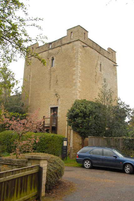
Longthorpe Tower

Longthorpe Tower is a 14th-century three-storey tower in the Longthorpe area of Peterborough, Cambridgeshire, England. It is famous for its well-preserved...

Longthorpe

Longthorpe is an area of the city of Peterborough, in the ceremonial county of Cambridgeshire, England. Located two miles (3.2 km) west from the city centre...

Netherton, Peterborough

Netherton is a residential area of the city of Peterborough, in the Peterborough district, in the ceremonial county of Cambridgeshire, England. For electoral...

Nearby Amenities

Located within 500m of 52.571605,-0.29254363
Motorway Junction
Thorpe Wood Interchange
Traffic Signals
Traffic Signals Direction: forward
Lat/Long: 52.5726057/-0.2966154
Turning Circle
Lat/Long: 52.5745135/-0.2925076
Turning Circle
Lat/Long: 52.5746135/-0.2953203
Turning Circle
Lat/Long: 52.5750843/-0.291047
Longthorpe
Is In: Peterborough
Place: suburb
Wikidata: Q11762555
Lat/Long: 52.5714019/-0.2853165
Post Box
Collection Times: Mo-Fr 18:00; Sa 13:00
Operator: Royal Mail
Post Box Type: pillar
Ref: PE3 130
Royal Cypher: GVIR
Royal Cypher Wikidata: Q33102169
Lat/Long: 52.5726474/-0.2879526
Pub
Fox & Hounds
Addr City: Peterborough
Addr Postcode: PE3 6NB
Addr Street: Thorpe Road
Brand: Chef & Brewer
Brand Wikidata: Q5089491
Diet Vegan: yes
Fhrs Id: 404381
Food: yes
Website: https://www.chefandbrewer.com/pubs/cambridgeshire/fox-and-hounds
Lat/Long: 52.5729101/-0.28826
Turning Circle
Lat/Long: 52.571629/-0.2854102
Stile: hipster
Traffic Calming: chicane
Lat/Long: 52.5702697/-0.2874002
Crossing
Bicycle: yes
Crossing: unmarked
Kerb: lowered
Sloped Curb: yes
Source: Bing
Lat/Long: 52.575013/-0.2961653
Crossing
Crossing: unmarked
Crossing Markings: no
Lat/Long: 52.5718046/-0.2957055
Police
Thorpe Wood Police Station
Opening Hours: Mo-Su 08:00-20:00
Lat/Long: 52.5702942/-0.2956656
Bus Stop
Fitzwilliam Hospital
Naptan AtcoCode: 0590PSB078
Naptan NaptanCode: PETDPGD
Public Transport: platform
Lat/Long: 52.5753803/-0.2956738
Bus Stop
Fitzwilliam Hospital
Public Transport: platform
Lat/Long: 52.5750358/-0.2955167
Bus Stop
Police Headquarters
Naptan AtcoCode: 0590PWT080
Naptan NaptanCode: PETDTPM
Public Transport: platform
Lat/Long: 52.57131/-0.2960563
Bus Stop
Police Headquarters
Naptan AtcoCode: 0590PWT079
Naptan NaptanCode: PETDTPJ
Public Transport: platform
Lat/Long: 52.5712944/-0.2958088
Bus Stop
Fox and Hounds
Bench: no
Public Transport: platform
Shelter: no
Lat/Long: 52.5731082/-0.2896947
Bus Stop
Fox and Hounds
Bench: no
Public Transport: platform
Shelter: no
Lat/Long: 52.5730136/-0.2897456
Crossing
Bicycle: yes
Crossing: unmarked
Kerb: lowered
Sloped Curb: yes
Lat/Long: 52.5700513/-0.2965091
Crossing
Bicycle: yes
Crossing: unmarked
Kerb: lowered
Sloped Curb: yes
Lat/Long: 52.5696423/-0.2961485
Crossing
Bicycle: yes
Crossing: unmarked
Kerb: lowered
Sloped Curb: yes
Lat/Long: 52.5704351/-0.296389
Traffic Signals
Source: Bing
Traffic Signals Direction: forward
Lat/Long: 52.5725619/-0.2964293
Street Lamp
Lat/Long: 52.5711152/-0.2856442
Street Lamp
Lat/Long: 52.5712955/-0.28601
Street Lamp
Lat/Long: 52.5713969/-0.2864532
Street Lamp
Lat/Long: 52.5722196/-0.2875956
Street Lamp
Lat/Long: 52.5727558/-0.2881891
Street Lamp
Lat/Long: 52.5731462/-0.2898113
Generator Method: photovoltaic
Generator Output Electricity: yes
Generator Source: solar
Generator Type: solar_photovoltaic_panel
Location: roof
Power: generator
Lat/Long: 52.575812/-0.2904591
Generator Method: photovoltaic
Generator Output Electricity: yes
Generator Source: solar
Generator Type: solar_photovoltaic_panel
Location: roof
Power: generator
Lat/Long: 52.5756262/-0.2908614
Generator Method: photovoltaic
Generator Output Electricity: yes
Generator Source: solar
Generator Type: solar_photovoltaic_panel
Location: roof
Power: generator
Lat/Long: 52.5737973/-0.2935007
Generator Method: photovoltaic
Generator Output Electricity: yes
Generator Source: solar
Generator Type: solar_photovoltaic_panel
Location: roof
Power: generator
Lat/Long: 52.5745227/-0.2937931
Generator Method: photovoltaic
Generator Output Electricity: yes
Generator Source: solar
Generator Type: solar_photovoltaic_panel
Location: roof
Power: generator
Lat/Long: 52.5738853/-0.2948123
Generator Method: photovoltaic
Generator Output Electricity: yes
Generator Source: solar
Generator Type: solar_photovoltaic_panel
Location: roof
Power: generator
Lat/Long: 52.5737549/-0.2949411
Generator Method: photovoltaic
Generator Output Electricity: yes
Generator Source: solar
Generator Type: solar_photovoltaic_panel
Location: roof
Power: generator
Lat/Long: 52.5743955/-0.2934363
Generator Method: photovoltaic
Generator Output Electricity: yes
Generator Source: solar
Generator Type: solar_photovoltaic_panel
Location: roof
Power: generator
Lat/Long: 52.5743931/-0.2933398
Generator Method: photovoltaic
Generator Output Electricity: yes
Generator Source: solar
Generator Type: solar_photovoltaic_panel
Location: roof
Power: generator
Lat/Long: 52.5741575/-0.2929884
TWG Sport
Addr City: Peterborough
Addr Postcode: PE3 6LU
Addr Street: Thorpe Road
Phone: +44 1733 332911;+44 1733 264460
Second Hand: yes
Service Vehicle Car Repair: yes
Service Vehicle Diagnostics: yes
Service Vehicle Used Car Sales: yes
Shop: car
Website: https://www.twgsport.co.uk/
Lat/Long: 52.5724162/-0.2883807
Entrance: yes
Lat/Long: 52.5708033/-0.2854483
Entrance: yes
Lat/Long: 52.5708495/-0.2867637
Barrier: cycle_barrier
Lat/Long: 52.5693343/-0.2885502
Barrier: cycle_barrier
Lat/Long: 52.5691868/-0.2886802
Post Box
Collection Times: Mo-Fr 09:00; Sa 07:00
Operator: Royal Mail
Operator Wikidata: Q638098
Post Box Type: lamp
Ref: PE3 350D
Lat/Long: 52.5695214/-0.2866884
Generator Method: photovoltaic
Generator Output Electricity: yes
Generator Source: solar
Generator Type: solar_photovoltaic_panel
Location: roof
Power: generator
Lat/Long: 52.5742407/-0.2896813
Generator Method: photovoltaic
Generator Output Electricity: yes
Generator Source: solar
Generator Type: solar_photovoltaic_panel
Location: roof
Power: generator
Lat/Long: 52.5748308/-0.2908963
Generator Method: photovoltaic
Generator Output Electricity: yes
Generator Source: solar
Generator Type: solar_photovoltaic_panel
Location: roof
Power: generator
Lat/Long: 52.5735035/-0.288725
Generator Method: photovoltaic
Generator Output Electricity: yes
Generator Source: solar
Generator Type: solar_photovoltaic_panel
Location: roof
Power: generator
Lat/Long: 52.5743906/-0.2868971
Generator Method: photovoltaic
Generator Output Electricity: yes
Generator Source: solar
Generator Type: solar_photovoltaic_panel
Location: roof
Power: generator
Lat/Long: 52.5744444/-0.2870983
Generator Method: photovoltaic
Generator Output Electricity: yes
Generator Source: solar
Generator Type: solar_photovoltaic_panel
Location: roof
Power: generator
Lat/Long: 52.5744249/-0.2878734
Generator Method: photovoltaic
Generator Output Electricity: yes
Generator Source: solar
Generator Type: solar_photovoltaic_panel
Location: roof
Power: generator
Lat/Long: 52.5737142/-0.290333
Generator Method: photovoltaic
Generator Output Electricity: yes
Generator Source: solar
Generator Type: solar_photovoltaic_panel
Location: roof
Power: generator
Lat/Long: 52.5723921/-0.2904859
Generator Method: photovoltaic
Generator Output Electricity: yes
Generator Source: solar
Generator Type: solar_photovoltaic_panel
Location: roof
Power: generator
Lat/Long: 52.5702811/-0.2877581
Generator Method: photovoltaic
Generator Output Electricity: yes
Generator Source: solar
Generator Type: solar_photovoltaic_panel
Location: roof
Power: generator
Lat/Long: 52.5700936/-0.290494
Generator Method: photovoltaic
Generator Output Electricity: yes
Generator Source: solar
Generator Type: solar_photovoltaic_panel
Location: roof
Power: generator
Lat/Long: 52.5700056/-0.2898717
Generator Method: photovoltaic
Generator Output Electricity: yes
Generator Source: solar
Generator Type: solar_photovoltaic_panel
Location: roof
Power: generator
Lat/Long: 52.569973/-0.2898127
Generator Method: photovoltaic
Generator Output Electricity: yes
Generator Source: solar
Generator Type: solar_photovoltaic_panel
Location: roof
Power: generator
Lat/Long: 52.570074/-0.2890563
Generator Method: photovoltaic
Generator Output Electricity: yes
Generator Source: solar
Generator Type: solar_photovoltaic_panel
Location: roof
Power: generator
Lat/Long: 52.5688253/-0.2902633
Generator Method: photovoltaic
Generator Output Electricity: yes
Generator Source: solar
Generator Type: solar_photovoltaic_panel
Location: roof
Power: generator
Lat/Long: 52.5684796/-0.2895176
Generator Method: photovoltaic
Generator Output Electricity: yes
Generator Source: solar
Generator Type: solar_photovoltaic_panel
Location: roof
Power: generator
Lat/Long: 52.5683753/-0.2893969
Generator Method: photovoltaic
Generator Output Electricity: yes
Generator Source: solar
Generator Type: solar_photovoltaic_panel
Location: roof
Power: generator
Lat/Long: 52.569047/-0.2885038
Generator Method: photovoltaic
Generator Output Electricity: yes
Generator Source: solar
Generator Type: solar_photovoltaic_panel
Location: roof
Power: generator
Lat/Long: 52.5698311/-0.2882838
Generator Method: photovoltaic
Generator Output Electricity: yes
Generator Source: solar
Generator Type: solar_photovoltaic_panel
Location: roof
Power: generator
Lat/Long: 52.5694382/-0.2878627
Generator Method: photovoltaic
Generator Output Electricity: yes
Generator Source: solar
Generator Type: solar_photovoltaic_panel
Location: roof
Power: generator
Lat/Long: 52.5684389/-0.2873611
Generator Method: photovoltaic
Generator Output Electricity: yes
Generator Source: solar
Generator Type: solar_photovoltaic_panel
Location: roof
Power: generator
Lat/Long: 52.5690348/-0.286928
Generator Method: photovoltaic
Generator Output Electricity: yes
Generator Source: solar
Generator Type: solar_photovoltaic_panel
Location: roof
Power: generator
Lat/Long: 52.5696551/-0.2861005
Noexit: yes
Lat/Long: 52.5677648/-0.294525
Entrance: yes
Lat/Long: 52.5703352/-0.2957753
Generator Method: photovoltaic
Generator Output Electricity: yes
Generator Source: solar
Generator Type: solar_photovoltaic_panel
Power: generator
Lat/Long: 52.5699348/-0.2969618
Generator Method: photovoltaic
Generator Output Electricity: yes
Generator Source: solar
Generator Type: solar_photovoltaic_panel
Power: generator
Lat/Long: 52.5695493/-0.2966137
Crossing
Lat/Long: 52.57342/-0.2913283
Addr City: Peterborough
Addr Housenumber: 7
Addr Street: Elliot Avenue
Lat/Long: 52.5759848/-0.2914097
Addr City: Peterborough
Addr Housenumber: 14
Addr Street: Elliot Avenue
Lat/Long: 52.5749972/-0.2912636
Addr City: Peterborough
Addr Housenumber: 16
Addr Street: Elliot Avenue
Lat/Long: 52.5748799/-0.2908425
Addr City: Peterborough
Addr Street: Elliot Avenue
Lat/Long: 52.5751244/-0.2906816
Addr City: Peterborough
Addr Housenumber: 15
Addr Street: Elliot Avenue
Lat/Long: 52.5753102/-0.2908425
Addr City: Peterborough
Addr Housenumber: 15
Addr Street: Elliot Avenue
Lat/Long: 52.5754895/-0.2909015
Addr City: Peterborough
Addr Housenumber: 11A
Addr Street: Elliot Avenue
Lat/Long: 52.5756395/-0.2909069
Addr City: Peterborough
Addr Housenumber: 11
Addr Street: Elliot Avenue
Lat/Long: 52.5757829/-0.290923
Addr City: Peterborough
Addr Housenumber: 9
Addr Street: Elliot Avenue
Lat/Long: 52.5758937/-0.2910785
Addr City: Peterborough
Addr Street: Elliot Avenue
Lat/Long: 52.575747/-0.2915399
Addr City: Peterborough
Addr Housenumber: 6
Addr Street: Elliot Avenue
Lat/Long: 52.5758774/-0.2917705
Addr City: Peterborough
Addr Housenumber: 4
Addr Street: Elliot Avenue
Lat/Long: 52.5759818/-0.2918939
Addr City: Peterborough
Addr Housenumber: 10
Addr Street: Elliot Avenue
Lat/Long: 52.5754732/-0.2914326
Addr City: Peterborough
Addr Housenumber: 12
Addr Street: Elliot Avenue
Lat/Long: 52.5752417/-0.2914433
Addr City: Peterborough
Addr Housenumber: 8
Addr Street: Elliot Avenue
Lat/Long: 52.5755139/-0.2918778
Addr City: Peterborough
Addr Housenumber: 12
Addr Street: Oak View
Lat/Long: 52.5755777/-0.2901354
Addr Housenumber: 10
Addr Street: Oak View
Lat/Long: 52.5752199/-0.2902574
Addr City: Peterborough
Addr Housenumber: 5
Addr Street: Oak View
Lat/Long: 52.5756942/-0.2894622
Addr City: Peterborough
Addr Housenumber: 11
Addr Street: Oak View
Lat/Long: 52.5754318/-0.2903687
Addr City: Peterborough
Addr Housenumber: 4
Addr Street: Oak View
Lat/Long: 52.5757545/-0.2897585
Public Bookcase
Lat/Long: 52.5708102/-0.2854318
Access: permissive
Man Made: water_tap
Lat/Long: 52.5707674/-0.2852908
Bench
Backrest: yes
Material: wood
Lat/Long: 52.5710025/-0.2856174
The data included in this document is from www.openstreetmap.org. The data is made available under ODbL.

Have you been to Thorpe Wood?

Leave your review of Thorpe Wood below (or comments, questions and feedback).