Nutfold Copse
Wood, Forest in Surrey Mole Valley
England
Nutfold Copse

Nutfold Copse is a picturesque woodland located in the county of Surrey, England. Situated in the southeastern part of the county, it covers an area of approximately 50 hectares. The copse is characterized by its dense foliage and diverse range of tree species, making it a popular destination for nature enthusiasts and hikers.
The woodland is primarily composed of broadleaf trees, including oak, beech, and birch. These majestic trees create a vibrant canopy that filters sunlight, creating a tranquil and shaded environment within the copse. The forest floor is covered with a rich carpet of wildflowers, mosses, and ferns, adding to the beauty and biodiversity of the area.
Nutfold Copse is home to a variety of wildlife, including birds, mammals, and insects. Birdwatchers can spot species such as woodpeckers, owls, and thrushes, while small mammals like squirrels and foxes can often be seen darting through the undergrowth. The copse also provides a habitat for numerous insects and invertebrates, contributing to the overall ecological balance of the area.
The copse is crisscrossed with several well-maintained walking trails, allowing visitors to explore the woodland at their own pace. These paths wind through the trees, offering glimpses of hidden ponds and streams that meander through the area. The copse is also a popular spot for picnics and family outings, with designated areas providing picnic tables and benches.
Overall, Nutfold Copse is a cherished natural treasure in Surrey, offering a peaceful escape from the hustle and bustle of everyday life and providing a haven for both flora and fauna.
If you have any feedback on the listing, please let us know in the comments section below.
Nutfold Copse Images
Images are sourced within 2km of 51.166523/-0.35340984 or Grid Reference TQ1542. Thanks to Geograph Open Source API. All images are credited.


Nutfold Copse is located at Grid Ref: TQ1542 (Lat: 51.166523, Lng: -0.35340984)
Administrative County: Surrey
District: Mole Valley
Police Authority: Surrey
What 3 Words
///dazzling.siesta.backswing. Near Holmwood, Surrey
Nearby Locations
Related Wikis

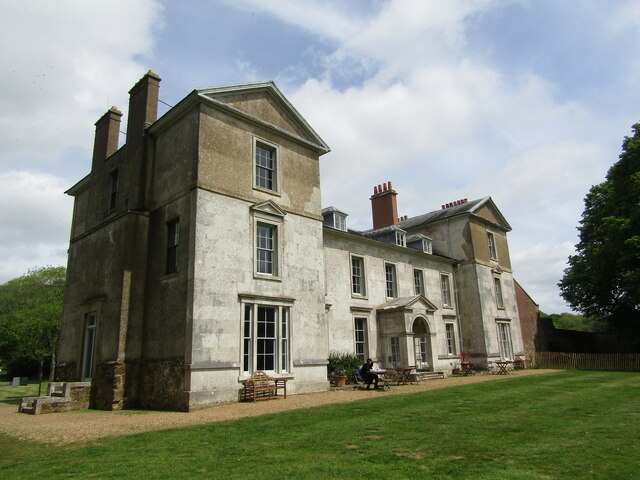
Broome Hall
Broome Hall is a Grade II-listed country house with grounds including cottages and outhouses on the wooded, upper southern slopes of the Greensand Ridge...

Greensand Ridge
The Greensand Ridge, also known as the Wealden Greensand, is an extensive, prominent, often wooded, mixed greensand/sandstone escarpment in south-east...

Leith Hill
Leith Hill in southern England is the highest summit of the Greensand Ridge, approximately 6.7 km (4 mi) southwest of Dorking, Surrey and 40.5 km (30 mi...

Leith Hill multiple aircraft accident
On 26 November 1944, four C-47 transport aircraft of the 442nd Operations Group departed from Advanced Landing Ground "A-4 in Pays de la Loire, northern...

Ockley railway station
Ockley railway station serves the villages of Ockley and Capel in Surrey, England and is 1.4 miles (2.3 km) from Ockley village and 0.5 miles (0.80 km...

Coldharbour, Surrey
Coldharbour is a hamlet in the Mole Valley district, in the English county of Surrey. It is on a minor road from Dorking to Leith Hill Place. == Description... ==

Ockley
Ockley is a rural village in Surrey. It lies astride the A29, the modern road using the alignment of Stane Street (Chichester). The A29 diverges from the...

Capel, Surrey
Capel () is a village and civil parish in southern Surrey, England. It is equidistant between Dorking and Horsham – about 5 miles (8.0 km) away. Around...
Nearby Amenities
Located within 500m of 51.166523,-0.35340984Have you been to Nutfold Copse?
Leave your review of Nutfold Copse below (or comments, questions and feedback).