Bushy Copse

Wood, Forest in Surrey Mole Valley

England

Bushy Copse

West from near Tanhurst Looking west from near Tanhurst, on the western slopes of Leith Hill.  In the far distance is Black Down.
West from near Tanhurst Credit: Ian Capper

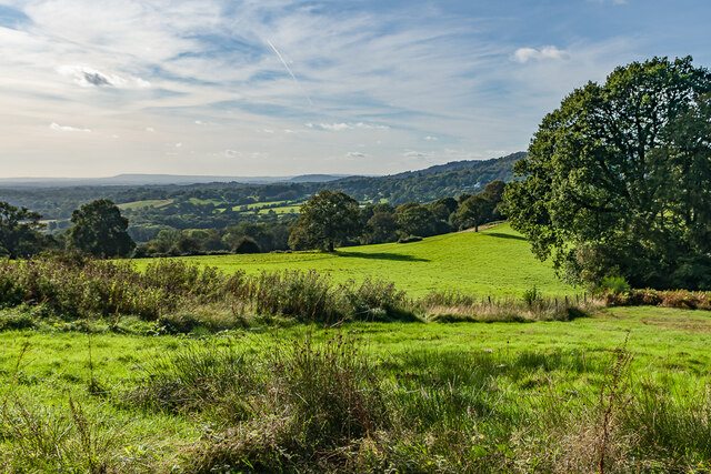
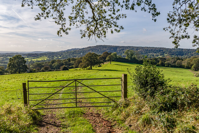
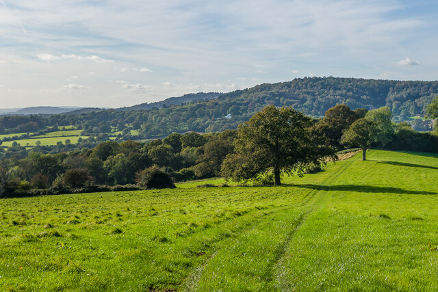
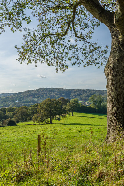
Bushy Copse is a picturesque woodland area located in Surrey, England. Covering an extensive area of approximately 500 acres, it is a haven for nature enthusiasts and outdoor enthusiasts alike. The copse is situated within the larger Surrey Hills Area of Outstanding Natural Beauty, adding to its scenic beauty and charm.

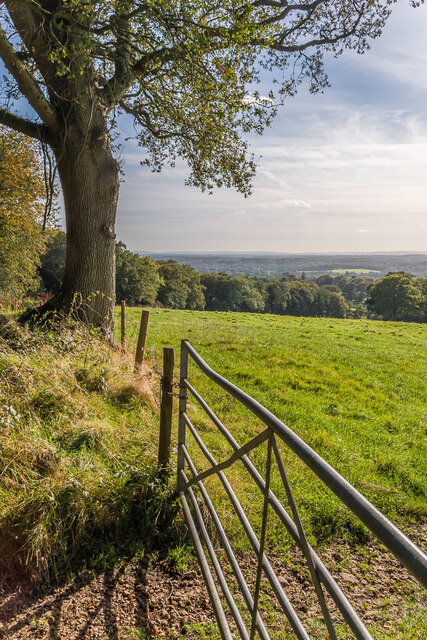
The woodland is characterized by its dense vegetation, consisting mainly of broadleaf trees such as oak, beech, and chestnut. These trees create a dense canopy, allowing only dappled sunlight to filter through, creating a tranquil and serene atmosphere. The forest floor is covered in a rich carpet of ferns, mosses, and wildflowers, further enhancing the natural beauty of the area.

Bushy Copse is home to a diverse array of wildlife, making it a popular spot for birdwatchers and wildlife enthusiasts. Visitors may spot a variety of bird species, including woodpeckers, owls, and various songbirds. The copse is also home to mammals such as deer, foxes, and badgers, which can occasionally be seen roaming through the trees.

The woodland is crisscrossed by a network of walking trails, offering visitors the opportunity to explore its beauty up close. These trails vary in length and difficulty, catering to both casual strollers and more experienced hikers. Along the way, visitors can take in breathtaking views of the surrounding countryside and enjoy the peaceful ambiance of the woodland.

Overall, Bushy Copse in Surrey is a captivating woodland area that offers a tranquil escape from the hustle and bustle of everyday life. With its diverse flora and fauna, scenic trails, and serene atmosphere, it is a must-visit destination for nature lovers and outdoor enthusiasts.

If you have any feedback on the listing, please let us know in the comments section below.

Bushy Copse Images

Images are sourced within 2km of 51.158677/-0.38865468 or Grid Reference TQ1241. Thanks to Geograph Open Source API. All images are credited.

West from near Tanhurst Looking west from near Tanhurst, on the western slopes of Leith Hill.  In the far distance is Black Down.
West from near Tanhurst
Looking west from near Tanhurst, on the western slopes of Leith Hill. In the far distance is Black Down.
West from near Tanhurst Looking west from near Tanhurst, on the western slopes of Leith Hill.  In the distance is Holmbury Hill.
West from near Tanhurst
Looking west from near Tanhurst, on the western slopes of Leith Hill. In the distance is Holmbury Hill.
West from near Tanhurst Looking west from near Tanhurst, on the western slopes of Leith Hill.  In the distance is Holmbury Hill.
West from near Tanhurst
Looking west from near Tanhurst, on the western slopes of Leith Hill. In the distance is Holmbury Hill.
West from near Tanhurst Looking west from near Tanhurst, on the western slopes of Leith Hill.  In the distance is Holmbury Hill.
West from near Tanhurst
Looking west from near Tanhurst, on the western slopes of Leith Hill. In the distance is Holmbury Hill.
South from near Tanhurst Looking south from near Tanhurst, on the western slopes of Leith Hill.  In the far distance are the South Downs.
South from near Tanhurst
Looking south from near Tanhurst, on the western slopes of Leith Hill. In the far distance are the South Downs.
Driveway Driveway for The Coach House, Tanhurst.
Driveway
Driveway for The Coach House, Tanhurst.
The Coach House The Coach House is on the left of the photo and was formerly the coach house to Tanhurst, a late 18th Century mansion.  For some years, Tanhurst was the home of Sir Edward and Lady Jane Vaughan Williams, grandparents to Ralph Vaughan Williams.  The Coach House was converted into its present form in 1960.  The building on the right, a former barn, was converted to holiday accommodation in the late 2010s.
The Coach House
The Coach House is on the left of the photo and was formerly the coach house to Tanhurst, a late 18th Century mansion. For some years, Tanhurst was the home of Sir Edward and Lady Jane Vaughan Williams, grandparents to Ralph Vaughan Williams. The Coach House was converted into its present form in 1960. The building on the right, a former barn, was converted to holiday accommodation in the late 2010s.
The Coach House The Coach House is in the centre of the photo and was formerly the coach house to Tanhurst, a late 18th Century mansion.  For some years, Tanhurst was the home of Sir Edward and Lady Jane Vaughan Williams, grandparents to Ralph Vaughan Williams.  The Coach House was converted into its present form in 1960.  The building on the right, a former barn, was converted to holiday accommodation in the late 2010s.
The Coach House
The Coach House is in the centre of the photo and was formerly the coach house to Tanhurst, a late 18th Century mansion. For some years, Tanhurst was the home of Sir Edward and Lady Jane Vaughan Williams, grandparents to Ralph Vaughan Williams. The Coach House was converted into its present form in 1960. The building on the right, a former barn, was converted to holiday accommodation in the late 2010s.
Leith Hill Place This property is now administered by the National Trust and previously has been home to Wedgwood, Darwin and Vaughan Williams families.
Leith Hill Place
This property is now administered by the National Trust and previously has been home to Wedgwood, Darwin and Vaughan Williams families.
Leith Hill Place - Graffiti Colourful graffiti in the cellar created probably in the 1960s when this house was a school.
Leith Hill Place - Graffiti
Colourful graffiti in the cellar created probably in the 1960s when this house was a school.
Leith Hill Place - Mural Schoolboy artwork, probably 1960s, in the cellar in this former school.
Leith Hill Place - Mural
Schoolboy artwork, probably 1960s, in the cellar in this former school.
Leith Hill Place - "The Lark Ascending" Detail from the Ralph Vaughan Williams timeline displayed in his former home - now a National Trust property.
Leith Hill Place - "The Lark Ascending"
Detail from the Ralph Vaughan Williams timeline displayed in his former home - now a National Trust property.
Leith Hill Place - Wedgwood Fireplace Wedgwood design on the fireplace with Darwinian exhibits above.
Leith Hill Place was home to Wedgwood, Darwin and Vaughan Williams families and is now administered by the National Trust.
Leith Hill Place - Wedgwood Fireplace
Wedgwood design on the fireplace with Darwinian exhibits above. Leith Hill Place was home to Wedgwood, Darwin and Vaughan Williams families and is now administered by the National Trust.
Leith Hill Place - Vaughan Williams Tryptych Three faces of Ralph Vaughan Williams, celebrated composer, in his former home near Dorking.
Leith Hill Place - Vaughan Williams Tryptych
Three faces of Ralph Vaughan Williams, celebrated composer, in his former home near Dorking.
Leith Hill Place This Palladian style house near Dorking has an Elizabethan kernel and has had a varied history - it has been home to Wedgwood, Darwin and Vaughan Williams families.
Leith Hill Place
This Palladian style house near Dorking has an Elizabethan kernel and has had a varied history - it has been home to Wedgwood, Darwin and Vaughan Williams families.
Leith Hill Place - Earthenware Exhibits in the kitchen - note the "stone pig" which was used as a bed warmer - it carries a maker's name, Pierson & Co of Dorking.
The house is now administered by the National Trust.
Leith Hill Place - Earthenware
Exhibits in the kitchen - note the "stone pig" which was used as a bed warmer - it carries a maker's name, Pierson & Co of Dorking. The house is now administered by the National Trust.
Leith Hill Place - Ralph Vaughan Williams Violin and bust of the celebrated composer in his former home SW of Dorking. This is now a National Trust property.
Leith Hill Place - Ralph Vaughan Williams
Violin and bust of the celebrated composer in his former home SW of Dorking. This is now a National Trust property.
Leith Hill Place - Ralph Vaughan Williams' Piano Exhibit within his former home which is now a National Trust property.
Leith Hill Place - Ralph Vaughan Williams' Piano
Exhibit within his former home which is now a National Trust property.
Show me another place!

Bushy Copse is located at Grid Ref: TQ1241 (Lat: 51.158677, Lng: -0.38865468)

Administrative County: Surrey

District: Mole Valley

Police Authority: Surrey

What 3 Words

///compiler.foresight.craziest. Near Ewhurst, Surrey

Related Wikis

Greensand Ridge

The Greensand Ridge, also known as the Wealden Greensand, is an extensive, prominent, often wooded, mixed greensand/sandstone escarpment in south-east...

Ockley

Ockley is a rural village in Surrey. It lies astride the A29, the modern road using the alignment of Stane Street (Chichester). The A29 diverges from the...

Leith Hill

Leith Hill in southern England is the highest summit of the Greensand Ridge, approximately 6.7 km (4 mi) southwest of Dorking, Surrey and 40.5 km (30 mi...

Leith Hill multiple aircraft accident

On 26 November 1944, four C-47 transport aircraft of the 442nd Operations Group departed from Advanced Landing Ground "A-4 in Pays de la Loire, northern...

Wallis Wood

Wallis Wood is a 14-hectare (35-acre) nature reserve south-east of Ewhurst in Surrey. It is managed by the Surrey Wildlife Trust.A stream runs through...

Joldwynds

Joldwynds is a modernist style house in Holmbury St Mary, Surrey, England, designed by architect Oliver Hill for Wilfred Greene, 1st Baron Greene. Completed...

Broome Hall

Broome Hall is a Grade II-listed country house with grounds including cottages and outhouses on the wooded, upper southern slopes of the Greensand Ridge...

Mullard Space Science Laboratory

The UCL Mullard Space Science Laboratory (MSSL) is the United Kingdom's largest university space research group. MSSL is part of the Department of Space...

Nearby Amenities

Located within 500m of 51.158677,-0.38865468
Forest Green
Place: hamlet
Source: npe
Lat/Long: 51.1605487/-0.3930568
Etherley Farm
Note Retag: CS #48756035
Place: farm
Source: npe
Lat/Long: 51.1627363/-0.3870315
Parking
Etherley Copse Car Park
Capacity: 6
Fee: no
Operator: National Trust
Parking: surface
Supervised: no
Wheelchair: limited
Lat/Long: 51.1627648/-0.3915437
Pub
The Parrot Inn
Addr City: Dorking
Addr Country: GB
Addr Postcode: RH5 5RZ
Lat/Long: 51.1597804/-0.3942284
Bus Stop
The Parrot
Naptan AtcoCode: 40004408206B
Naptan Bearing: S
Naptan CommonName: Old Garage
Naptan Indicator: Just Before
Naptan Landmark: Old Garage
Naptan NaptanCode: surdapwj
Naptan Street: Horsham Road
Naptan Verified: no
Physically Present: no
Public Transport: platform
Source: naptan_import
Lat/Long: 51.1590688/-0.3944809
Bus Stop
The Parrot
Naptan AtcoCode: 40004408206C
Naptan Bearing: N
Naptan CommonName: Old Garage
Naptan Indicator: Just after
Naptan Landmark: Old Garage
Naptan NaptanCode: surdapwm
Naptan Street: Horsham Road
Naptan Verified: no
Physically Present: no
Public Transport: platform
Source: naptan_import
Lat/Long: 51.1591888/-0.3947056
Power: pole
Lat/Long: 51.1575706/-0.3828792
Power: pole
Lat/Long: 51.157288/-0.3842472
Power: pole
Lat/Long: 51.1569717/-0.3859719
Power: pole
Lat/Long: 51.1565815/-0.3878789
Power: pole
Lat/Long: 51.1562332/-0.3897484
Power: pole
Lat/Long: 51.1557554/-0.3928517
Barrier: stile
Lat/Long: 51.1578156/-0.3934193
Old Garage
Bus: yes
Public Transport: stop_position
Lat/Long: 51.1590887/-0.3946093
Power: pole
Lat/Long: 51.1558339/-0.392839
Power: pole
Lat/Long: 51.1559903/-0.3914148
Power: pole
Lat/Long: 51.1563116/-0.3897545
Power: pole
Lat/Long: 51.1566582/-0.3878608
Power: pole
Lat/Long: 51.1570384/-0.3860289
Power: pole
Lat/Long: 51.1573765/-0.384272
Power: pole
Lat/Long: 51.1559029/-0.3913906
Power: pole
Lat/Long: 51.1576558/-0.3829041
Power: pole
Source: Bing
Lat/Long: 51.1582227/-0.3923589
Power: pole
Source: Bing
Lat/Long: 51.1574354/-0.3893334
Power: pole
Source: Bing
Lat/Long: 51.1566817/-0.3884308
Power: pole
Source: Bing
Lat/Long: 51.1559214/-0.3875256
Power: pole
Source: Bing
Lat/Long: 51.155166/-0.3866297
Power: pole
Source: Bing
Lat/Long: 51.154552/-0.3859162
Gosterwood Manor
Place: isolated_dwelling
Lat/Long: 51.1611783/-0.3916725
Advertising: board
Lat/Long: 51.157369/-0.3947926
Public Bookcase
Booth: K6
Disused Amenity: telephone
Man Made: telephone_box
Public Bookcase Type: phone_box
Lat/Long: 51.1574239/-0.3948748
Bus Stop
Etherley Hill
Naptan AtcoCode: 40004408802B
Naptan NaptanCode: surdawdg
Physically Present: no
Public Transport: platform
Lat/Long: 51.1612194/-0.3867142
Bus Stop
Horsham Road End
Naptan AtcoCode: 40004408814C
Naptan NaptanCode: surdgdmg
Physically Present: no
Public Transport: platform
Lat/Long: 51.1616043/-0.3939281
Bus Stop
Etherley Hill
Naptan AtcoCode: 40004408802G
Naptan NaptanCode: surdawgd
Physically Present: no
Public Transport: platform
Lat/Long: 51.161089/-0.3867239
The data included in this document is from www.openstreetmap.org. The data is made available under ODbL.

Have you been to Bushy Copse?

Leave your review of Bushy Copse below (or comments, questions and feedback).