High Copse

Wood, Forest in Surrey Waverley

England

High Copse

Ewhurst Windmill
Ewhurst Windmill Credit: Alex McGregor

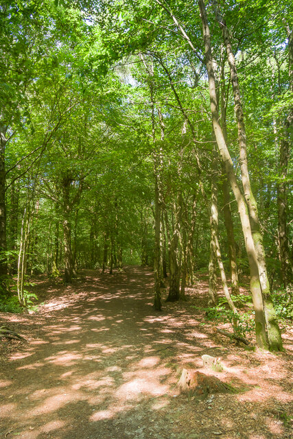
High Copse is a charming woodland located in the county of Surrey, England. Situated in the southeastern part of the country, High Copse is known for its picturesque beauty and rich biodiversity. Covering an area of approximately 50 acres, the woodland is primarily composed of a mixture of deciduous and evergreen trees, creating a vibrant and enchanting atmosphere.

The diverse range of tree species found in High Copse includes oak, beech, birch, and pine, among others. This variety of trees provides a habitat for a wide array of wildlife, including birds, squirrels, and deer. Birdwatchers and nature enthusiasts are often drawn to the woodland to observe the different species of birds that inhabit the area.

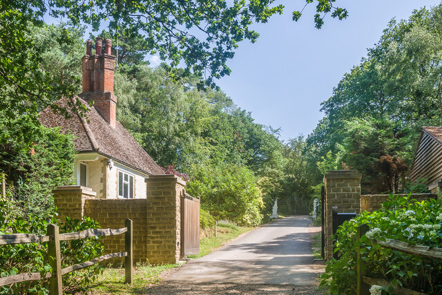
High Copse offers a tranquil retreat for visitors seeking a peaceful escape from the hustle and bustle of everyday life. The woodland is crisscrossed by a network of well-maintained walking trails, allowing visitors to explore its natural beauty at their own pace. These trails wind through the trees, offering glimpses of wildflowers and small streams along the way.

The forest is a popular destination for outdoor activities such as hiking, picnicking, and wildlife spotting. Many visitors enjoy the opportunity to reconnect with nature and take in the fresh air and serene surroundings. The management of High Copse ensures the preservation of its natural environment, making it an ideal location for nature lovers and those seeking a serene retreat.

If you have any feedback on the listing, please let us know in the comments section below.

High Copse Images

Images are sourced within 2km of 51.156663/-0.46082604 or Grid Reference TQ0740. Thanks to Geograph Open Source API. All images are credited.
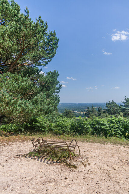
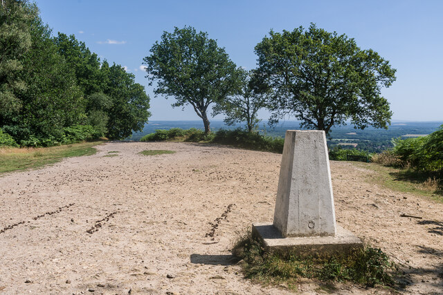
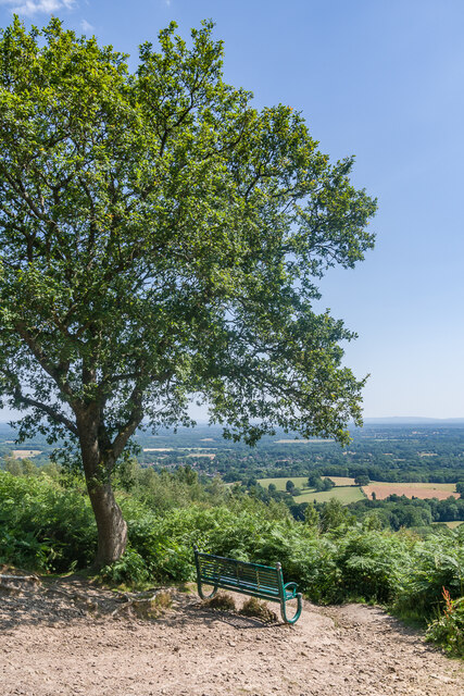
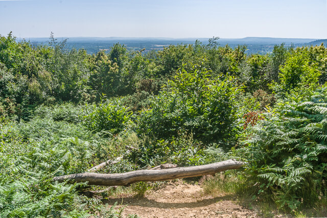
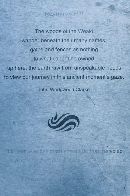
Ewhurst Windmill
Ewhurst Windmill
Pitch Hill
Pitch Hill
Pitch Hill Seat near the summit of Pitch Hill.
Pitch Hill
Seat near the summit of Pitch Hill.
Pitch Hill Seat near the summit of Pitch Hill.
Pitch Hill
Seat near the summit of Pitch Hill.
Pitch Hill Trig point at the summit of Pitch Hill.
Pitch Hill
Trig point at the summit of Pitch Hill.
Pitch Hill Seat at the summit of Pitch Hill.
Pitch Hill
Seat at the summit of Pitch Hill.
Ewhurst Windmill Windmill built in 1845, replacing an earlier post mill on the site.  It ceased to operate c.1885 and was converted to residential use c.1901.  The current sails dated from 1937.  Grade II listed - see <span class="nowrap"><a title="https://historicengland.org.uk/listing/the-list/list-entry/1190554?section=official-list-entry" rel="nofollow ugc noopener" href="https://historicengland.org.uk/listing/the-list/list-entry/1190554?section=official-list-entry">Link</a><img style="margin-left:2px;" alt="External link" title="External link - shift click to open in new window" src="https://s1.geograph.org.uk/img/external.png" width="10" height="10"/></span>.
Ewhurst Windmill
Windmill built in 1845, replacing an earlier post mill on the site. It ceased to operate c.1885 and was converted to residential use c.1901. The current sails dated from 1937. Grade II listed - see LinkExternal link.
Summerfold Lodge Lodge to Summerfold, an early 20th Century mansion built for a railway engineer named William Clarke, designed by Reginald Cuthbert Fry.  Originally named The Warren, work started in 1913 but the building wasn't completed until after the end of the First World War.  In 1924 it was bought by the Duke Of Sutherland and was renamed Summerfold.  Its most famous resident was Edward, Prince of Wales, later Edward VIII, who leased it in 1927.
Summerfold Lodge
Lodge to Summerfold, an early 20th Century mansion built for a railway engineer named William Clarke, designed by Reginald Cuthbert Fry. Originally named The Warren, work started in 1913 but the building wasn't completed until after the end of the First World War. In 1924 it was bought by the Duke Of Sutherland and was renamed Summerfold. Its most famous resident was Edward, Prince of Wales, later Edward VIII, who leased it in 1927.
 Reynards Hill A shaded path on Reynards Hill.
Reynards Hill
A shaded path on Reynards Hill.
Reynards Hill The view east from Reynards Hill.
Reynards Hill
The view east from Reynards Hill.
 Reynards Hill The view southwest from Reynards Hill.
Reynards Hill
The view southwest from Reynards Hill.
Reynards Hill The summit clearing on Reynards Hill.  The seat was installed in 2016.  Created by the artist Russell Jakubowski, and entitled Contour, it is made from a lamination of recycled plastic and marine grade stainless steel - see <span class="nowrap"><a title="https://www.axisweb.org/p/russelljakubowski/workset/226591-contour-seat/" rel="nofollow ugc noopener" href="https://www.axisweb.org/p/russelljakubowski/workset/226591-contour-seat/">Link</a><img style="margin-left:2px;" alt="External link" title="External link - shift click to open in new window" src="https://s1.geograph.org.uk/img/external.png" width="10" height="10"/></span>.  For a close up of the plaque on the seat see <a href="https://www.geograph.org.uk/photo/7645999">TQ0742 : Plaque on "Contour", Reynards Hill</a>].
Reynards Hill
The summit clearing on Reynards Hill. The seat was installed in 2016. Created by the artist Russell Jakubowski, and entitled Contour, it is made from a lamination of recycled plastic and marine grade stainless steel - see LinkExternal link. For a close up of the plaque on the seat see TQ0742 : Plaque on "Contour", Reynards Hill].
Plaque on "Contour", Reynards Hill The plaque on the seat at the summit of Reynards Hill, installed in 2016 - see <a href="https://www.geograph.org.uk/photo/7645988">TQ0742 : Reynards Hill</a>.  Created by the artist Russell Jakubowski, and entitled Contour, the seat is made from a lamination of recycled plastic and marine grade stainless steel.  The plaque reads: 

"Reynards Hill

The woods of the Weald wander beneath their many names, gates and fences as nothing to what cannot be owned up here, the earth raw from unspeakable needs to view our journey in this ancient moment's gaze.

John Wedgwood Clarke

This seat was designed and made from recycled plastic by the artist Russell Jakubowski.  It has been created for you to enjoy this inspiring view."

The logo is that of the Surrey Hills AONB.
Plaque on "Contour", Reynards Hill
The plaque on the seat at the summit of Reynards Hill, installed in 2016 - see TQ0742 : Reynards Hill. Created by the artist Russell Jakubowski, and entitled Contour, the seat is made from a lamination of recycled plastic and marine grade stainless steel. The plaque reads: "Reynards Hill The woods of the Weald wander beneath their many names, gates and fences as nothing to what cannot be owned up here, the earth raw from unspeakable needs to view our journey in this ancient moment's gaze. John Wedgwood Clarke This seat was designed and made from recycled plastic by the artist Russell Jakubowski. It has been created for you to enjoy this inspiring view." The logo is that of the Surrey Hills AONB.
2016: a year on Geograph (Day 171) A wonderful day begins at the Cranleigh Show <span class="nowrap"><a title="http://www.cranleighshow.co.uk/cranleigh-show" rel="nofollow ugc noopener" href="http://www.cranleighshow.co.uk/cranleigh-show">Link</a><img style="margin-left:2px;" alt="External link" title="External link - shift click to open in new window" src="https://s1.geograph.org.uk/img/external.png" width="10" height="10"/></span>
2016: a year on Geograph (Day 171)
A wonderful day begins at the Cranleigh Show LinkExternal link
A wonderful day at the Cranleigh Show (3) No need to be sheepish!
A wonderful day at the Cranleigh Show (3)
No need to be sheepish!
A wonderful day at the Cranleigh Show (4) The annual Cranleigh show is held on this ground every year. The show is a traditional agricultural show and is run, owned and operated by the Cranleigh and South Eastern Agricultural Society. It took over from the Cranleigh and West Surrey Farming Club in 1981..
Website: <span class="nowrap"><a title="http://www.cranleighshow.org.uk/" rel="nofollow ugc noopener" href="http://www.cranleighshow.org.uk/">Link</a><img style="margin-left:2px;" alt="External link" title="External link - shift click to open in new window" src="https://s1.geograph.org.uk/img/external.png" width="10" height="10"/></span>
A wonderful day at the Cranleigh Show (4)
The annual Cranleigh show is held on this ground every year. The show is a traditional agricultural show and is run, owned and operated by the Cranleigh and South Eastern Agricultural Society. It took over from the Cranleigh and West Surrey Farming Club in 1981.. Website: LinkExternal link
A wonderful day at the Cranleigh Show (7) No trick photography, he's simply flying!
A wonderful day at the Cranleigh Show (7)
No trick photography, he's simply flying!
Show me another place!

High Copse is located at Grid Ref: TQ0740 (Lat: 51.156663, Lng: -0.46082604)

Administrative County: Surrey

District: Waverley

Police Authority: Surrey

What 3 Words

///overtones.vets.historic. Near Ewhurst, Surrey

Related Wikis

Sayer's Croft LNR

Sayer's Croft is a 10.9-hectare (27-acre) Local Nature Reserve west of Ewhurst in Surrey. It is owned by the Sayer's Croft Environmental Education Trust...

Sayers Croft

Sayers Croft is a large outdoor 'learning camp' located in the village of Ewhurst, Surrey. It is one of the few remaining 'Camp schools' built by the National...

Marylands

Marylands is a Spanish-style country house on Pitch Hill, a rural part of Ewhurst, Surrey, England. It is a Grade II* listed building, designed during...

Ewhurst, Surrey

Ewhurst is a rural village and civil parish in the borough of Waverley in Surrey, England. It is located 8.3 miles (13.4 km) south-east of Guildford,...

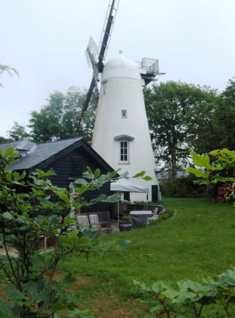
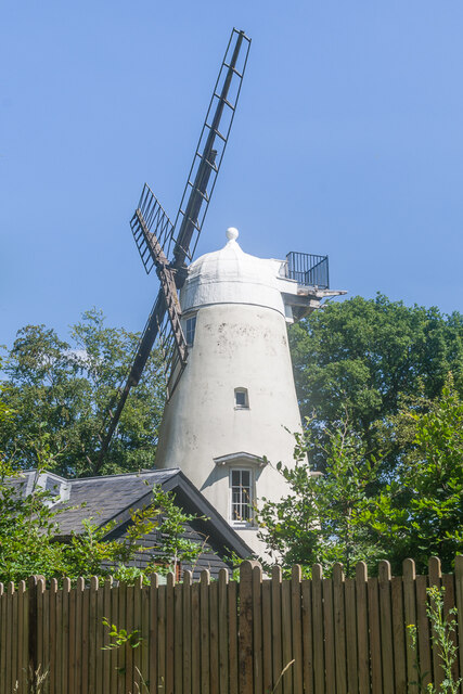
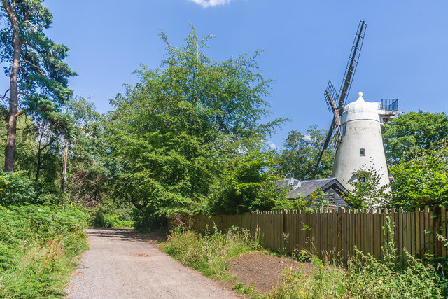
Hurt Wood Mill, Ewhurst

Hurt Wood Mill is a grade II* listed tower mill at Ewhurst, Surrey, England, which has been converted to residential use. == History == Hurt Wood Mill...

Duke of Kent School

Duke of Kent School is a 3–16 mixed private school in Ewhurst, Surrey, England. The school was originally founded in 1920 at Vanbrugh Castle to provide...

Glebelands School

Glebelands School is a county-funded and charity-supported secondary school in Cranleigh, Surrey, England. It is co-educational and takes students aged...

Cranleigh School

Cranleigh School is a public school (English fee-charging boarding and day school) in the village of Cranleigh, Surrey. == History == It was opened on...

Nearby Amenities

Located within 500m of 51.156663,-0.46082604
Power: pole
Lat/Long: 51.1563274/-0.45377
Power: pole
Lat/Long: 51.1561104/-0.4556583
Power: pole
Lat/Long: 51.1560952/-0.4570879
Power: pole
Lat/Long: 51.1563022/-0.4582332
Power: pole
Lat/Long: 51.1566739/-0.460151
Power: pole
Lat/Long: 51.1569707/-0.4620406
Power: pole
Lat/Long: 51.1567345/-0.4631866
Power: pole
Lat/Long: 51.1561491/-0.4652606
Power: pole
Lat/Long: 51.1556949/-0.4667921
Barrier: stile
Lat/Long: 51.1530925/-0.4568526
Barrier: stile
Lat/Long: 51.1529362/-0.4577118
Barrier: stile
Lat/Long: 51.1529586/-0.457805
Barrier: stile
Lat/Long: 51.1522276/-0.4601676
Barrier: stile
Lat/Long: 51.1565582/-0.4622399
Barrier: stile
Lat/Long: 51.1567248/-0.4629013
Barrier: stile
Lat/Long: 51.1568675/-0.4619633
Power: pole
Lat/Long: 51.1557548/-0.4668492
Power: pole
Lat/Long: 51.156209/-0.4652882
Power: pole
Lat/Long: 51.1567894/-0.4632014
Power: pole
Lat/Long: 51.1570445/-0.4619998
Power: pole
Lat/Long: 51.1566616/-0.4586175
Power: pole
Lat/Long: 51.1564042/-0.4570726
Power: pole
Lat/Long: 51.1562006/-0.4556912
Power: pole
Lat/Long: 51.1563991/-0.4538217
Turning Circle
Lat/Long: 51.1551756/-0.461688
Roman Tile Kiln
Archaeological Site: industrial
Historic: archaeological_site
Historic Civilization: roman
Lat/Long: 51.1572989/-0.4564331
The data included in this document is from www.openstreetmap.org. The data is made available under ODbL.

Have you been to High Copse?

Leave your review of High Copse below (or comments, questions and feedback).