Elder Wood

Wood, Forest in Lincolnshire South Kesteven

England

Elder Wood

Arched with trees
Arched with trees Credit: Bob Harvey

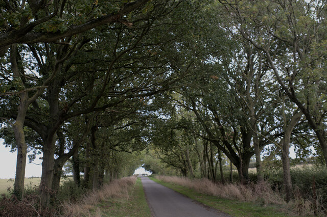
Elder Wood is a picturesque forest located in the county of Lincolnshire, England. Covering an area of approximately 500 acres, it is a prominent natural landmark in the region. The wood is named after the abundance of elder trees that can be found throughout the area, contributing to its unique charm.

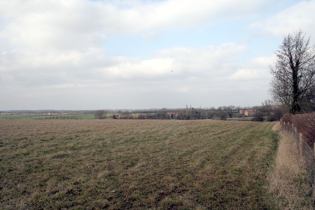
The forest is home to a diverse range of wildlife, including several species of birds, mammals, and insects. Visitors to Elder Wood have the opportunity to observe and appreciate the natural beauty of the surrounding environment. The tranquil atmosphere and peaceful surroundings make it an ideal destination for nature lovers and those seeking solace in the great outdoors.

Walking trails wind through the woodland, allowing visitors to explore at their leisure. The well-maintained paths provide easy access to various points of interest, such as ancient trees, small streams, and clearings. Additionally, there are designated picnic areas where visitors can relax and enjoy a meal amidst the natural splendor.

Elder Wood holds historical significance as well, with evidence of human presence dating back to ancient times. Archaeological discoveries suggest that the wood was once inhabited by early settlers, and remnants of their dwellings can still be found within the forest.

Overall, Elder Wood offers a captivating escape from the hustle and bustle of everyday life. Its rich biodiversity, scenic beauty, and historical significance make it a popular destination for locals and tourists alike.

If you have any feedback on the listing, please let us know in the comments section below.

Elder Wood Images

Images are sourced within 2km of 52.75194/-0.44062235 or Grid Reference TF0518. Thanks to Geograph Open Source API. All images are credited.

Arched with trees
Arched with trees
Power lines near Lound The 132kV single circuit feed line PR from near Maxey to Bourne.
Power lines near Lound
The 132kV single circuit feed line PR from near Maxey to Bourne.
Lound Lane
Lound Lane
Bridge, Toft An early C19th limestone bridge consisting of a single segmental arch. Grade II listed.
It now carries the A6121 over the East Glen River.
Bridge, Toft
An early C19th limestone bridge consisting of a single segmental arch. Grade II listed. It now carries the A6121 over the East Glen River.
A hill in Lincolnshire
Looking across barley fields towards Scottlethorpe Grange
End of Halehouse Road at Hale House ruin, Grimsthorpe Estate Public access along the road/track leading south west from Scottlethorpe along the east side of Grimsthorpe Park ends here (the track turns left into a shooting range). However, other tracks do allow egress to Little Bytham.
End of Halehouse Road at Hale House ruin, Grimsthorpe Estate
Public access along the road/track leading south west from Scottlethorpe along the east side of Grimsthorpe Park ends here (the track turns left into a shooting range). However, other tracks do allow egress to Little Bytham.
Church of St Andrew, Witham on the Hill Earliest portions are mid 12th C. In 1736 the original tower and spire collapsed; the lives of the bell ringers being saved because they were taking a mid-session break at the local tavern.
Church of St Andrew, Witham on the Hill
Earliest portions are mid 12th C. In 1736 the original tower and spire collapsed; the lives of the bell ringers being saved because they were taking a mid-session break at the local tavern.
Cottages, Witham on the Hill At the entrance to this attractive village, on the road from Little Bytham
Cottages, Witham on the Hill
At the entrance to this attractive village, on the road from Little Bytham
Witham Hall, Witham on the Hill Dating from the 18th C. Now a preparatory school
Witham Hall, Witham on the Hill
Dating from the 18th C. Now a preparatory school
Track leading from Lings Farm View north toward its entrance on the Little Bytham to Witham on the Hill road.
Lings Farm is named Careby Farm on the older OS map.
Track leading from Lings Farm
View north toward its entrance on the Little Bytham to Witham on the Hill road. Lings Farm is named Careby Farm on the older OS map.
Sunday cricket, Witham on the Hill
Bridleway northwards down Fountains Hill Many of the fields in this area had been harvested by mid July
Bridleway northwards down Fountains Hill
Many of the fields in this area had been harvested by mid July
Bridleway north from Witham on the Hill A good bridleway runs north from Witham on the Hill to the disused railway track at Elder Wood
Bridleway north from Witham on the Hill
A good bridleway runs north from Witham on the Hill to the disused railway track at Elder Wood
View to Elderwood Cottage From the bridleway running north from Witham on the Hill
View to Elderwood Cottage
From the bridleway running north from Witham on the Hill
Show me another place!

Elder Wood is located at Grid Ref: TF0518 (Lat: 52.75194, Lng: -0.44062235)

Administrative County: Lincolnshire

District: South Kesteven

Police Authority: Lincolnshire

What 3 Words

///tangible.tonsils.lawfully. Near Bourne, Lincolnshire

Nearby Locations

Elder Wood

Related Wikis

Bourne Rural District

Bourne was a rural district in Lincolnshire, Parts of Kesteven from 1894 to 1931. It was created by the Local Government Act 1894 based on the Bourne rural...

Witham Hall

Witham Hall is an independent boarding and day school situated in Witham on the Hill, Lincolnshire, England. == The hall == The house is described by Sir...

Lound, Lincolnshire

Lound is a village in the South Kesteven district of Lincolnshire, England. It is situated about 2 miles (3 km) south-west from the town of Bourne. Originally...

Witham on the Hill

Witham on the Hill is a village and civil parish in the South Kesteven district of Lincolnshire, England. The population of the civil parish was 260 at...

Nearby Amenities

Located within 500m of 52.75194,-0.44062235
Power: pole
Lat/Long: 52.7506716/-0.4465974
Power: pole
Lat/Long: 52.751111/-0.4452985
Power: pole
Lat/Long: 52.7517321/-0.4439925
Power: pole
Lat/Long: 52.7521044/-0.4424438
Power: pole
Lat/Long: 52.752489/-0.4411614
Power: pole
Lat/Long: 52.752902/-0.4398723
Power: pole
Lat/Long: 52.7532815/-0.4386219
Power: pole
Lat/Long: 52.753719/-0.4372653
Power: pole
Lat/Long: 52.7541586/-0.4359037
The data included in this document is from www.openstreetmap.org. The data is made available under ODbL.

Have you been to Elder Wood?

Leave your review of Elder Wood below (or comments, questions and feedback).