Abergarwed

Settlement in Glamorgan

Wales

Abergarwed

South Eastern View from Cerdded Bro Nedd Footpath A way-marked footpath that encircles the Vale of Neath. On its north-west side it includes part of the Sarn Helen Roman Road (Neath to Brecon) footpath, and on its south-east side links with the Coed Morgannwg Way (Margam to Aberdare).
South Eastern View from Cerdded Bro Nedd Footpath Credit: Kev Griffin

Abergarwed is a small village located in the county of Glamorgan, Wales. Situated in the picturesque Afan Valley, this charming village is surrounded by rolling hills and breathtaking natural beauty. Abergarwed is part of the Neath Port Talbot local authority area and lies approximately 10 miles northeast of the town of Neath.

The village itself is known for its peaceful and idyllic atmosphere, making it a popular destination for those seeking a tranquil retreat. Abergarwed is also steeped in history, with evidence of human habitation dating back thousands of years. The nearby ruins of Ynysarwed Lodge, a former mansion house, are a testament to the area's rich heritage.

In terms of amenities, Abergarwed offers a range of services to its residents and visitors. The village has a community center, a primary school, and a pub, providing a sense of community and social gathering places. The surrounding area offers ample opportunities for outdoor activities, such as hiking, cycling, and fishing, with the Afan Forest Park being a particular highlight.

Despite its small size, Abergarwed has a close-knit community that takes pride in preserving its heritage and natural surroundings. The village hosts various events throughout the year, including festivals and fairs, which bring locals and visitors together to celebrate the area's traditions and culture.

Overall, Abergarwed is a hidden gem in Glamorgan, offering a peaceful escape from the hustle and bustle of city life while providing a rich historical and natural backdrop for residents and tourists alike.

If you have any feedback on the listing, please let us know in the comments section below.

Abergarwed Images

Images are sourced within 2km of 51.707063/-3.713672 or Grid Reference SN8102. Thanks to Geograph Open Source API. All images are credited.

South Eastern View from Cerdded Bro Nedd Footpath A way-marked footpath that encircles the Vale of Neath. On its north-west side it includes part of the Sarn Helen Roman Road (Neath to Brecon) footpath, and on its south-east side links with the Coed Morgannwg Way (Margam to Aberdare).
South Eastern View from Cerdded Bro Nedd Footpath
A way-marked footpath that encircles the Vale of Neath. On its north-west side it includes part of the Sarn Helen Roman Road (Neath to Brecon) footpath, and on its south-east side links with the Coed Morgannwg Way (Margam to Aberdare).
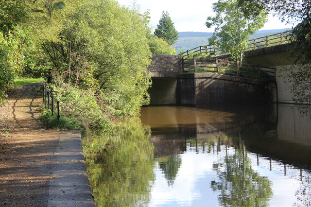
Neath Canal at A465 underpass, Ynys-bwllog The realigned canal turns and passes under the dual carriageway to a baisin <a href="https://www.geograph.org.uk/photo/6979784">SN8001 : Baisin, Neath Canal, by road bridge, A465</a>. The towpath carries NCR 46; the railing to the right guards a slipway.
Neath Canal at A465 underpass, Ynys-bwllog
The realigned canal turns and passes under the dual carriageway to a baisin SN8001 : Baisin, Neath Canal, by road bridge, A465. The towpath carries NCR 46; the railing to the right guards a slipway.
Neath Canal at footbridge next to A465, Ynys-bwllog The bridge carries the towpath over the end of a realigned section of the canal.
Neath Canal at footbridge next to A465, Ynys-bwllog
The bridge carries the towpath over the end of a realigned section of the canal.
Grass track to bungalow on Neath Road Driveway from canal towpath <a href="https://www.geograph.org.uk/photo/6979624">SN8001 : Neath Canal at footbridge next to A465, Ynys-bwllog</a> on approach to bridge.
Grass track to bungalow on Neath Road
Driveway from canal towpath SN8001 : Neath Canal at footbridge next to A465, Ynys-bwllog on approach to bridge.
Neath Canal just above footbridge Vegetation appears to be encroaching on the canal here; the brown colour is probably the result of recent heavy rain.
Neath Canal just above footbridge
Vegetation appears to be encroaching on the canal here; the brown colour is probably the result of recent heavy rain.
Pipe over Neath Canal at Ynys Arwed Cottages The metal pipe is probably carrying sewage to a treatment plant on the right, out of shot. The yellow notice on the brick pillar says, 'Mind your head'.
Pipe over Neath Canal at Ynys Arwed Cottages
The metal pipe is probably carrying sewage to a treatment plant on the right, out of shot. The yellow notice on the brick pillar says, 'Mind your head'.
Canalside gardens, Ynys Arwed Cottages Gardens behind row of houses on Neath Road.
Canalside gardens, Ynys Arwed Cottages
Gardens behind row of houses on Neath Road.
River Neath below Ynysbwllog Aqueduct River in spate after heavy rains.
River Neath below Ynysbwllog Aqueduct
River in spate after heavy rains.
River Neath above Ynysbwllog Aqueduct River in spate after heavy rains.
River Neath above Ynysbwllog Aqueduct
River in spate after heavy rains.
Neath Canal southwest from aqueduct Trees and bushes are encroaching on one side of the canal.
Neath Canal southwest from aqueduct
Trees and bushes are encroaching on one side of the canal.
Baisin, Neath Canal, by road bridge, A465 Side of baisin at end of a realigned section of the canal; the canal on the far side of the bridge is in <a href="https://www.geograph.org.uk/photo/6979612">SN8001 : Neath Canal at A465 underpass, Ynys-bwllog</a>.
Baisin, Neath Canal, by road bridge, A465
Side of baisin at end of a realigned section of the canal; the canal on the far side of the bridge is in SN8001 : Neath Canal at A465 underpass, Ynys-bwllog.
Open gates at level crossing, Ynys-dwfnant Private crossing to riverside farm, Ynys-dwfnant Farm, on little used railway line <a href="https://www.geograph.org.uk/photo/6988359">SN8101 : Railway line at level crossing</a>.
Open gates at level crossing, Ynys-dwfnant
Private crossing to riverside farm, Ynys-dwfnant Farm, on little used railway line SN8101 : Railway line at level crossing.
Railway line at level crossing Little used line at crossing <a href="https://www.geograph.org.uk/photo/6987565">SN8101 : Open gates at level crossing, Ynys-dwfnant</a> above Ynys-dwfnant Farm.
Railway line at level crossing
Little used line at crossing SN8101 : Open gates at level crossing, Ynys-dwfnant above Ynys-dwfnant Farm.
Derelict house, Ynys-dwfnant Farm Detached stone house, there is a large inhabited house to the left out of shot.
Derelict house, Ynys-dwfnant Farm
Detached stone house, there is a large inhabited house to the left out of shot.
Ordnance Survey Cut Mark This OS cut mark can be found on No29 Commercial Road. It marks a point 35.619m above mean sea level.
Ordnance Survey Cut Mark
This OS cut mark can be found on No29 Commercial Road. It marks a point 35.619m above mean sea level.
Track East Of Cymla-bach Ruin
Cymla-bach Ruin
Cymla-bach Ruin
Towards Cymla-bach
Towards Cymla-bach
Show me another place!

Abergarwed is located at Grid Ref: SN8102 (Lat: 51.707063, Lng: -3.713672)

Unitary Authority: Neath Port Talbot

Police Authority: South Wales

Also known as: Aber-Garwed

What 3 Words

///cosmic.bunny.sardine. Near Resolven, Neath Port Talbot

Nearby Locations

Abergarwed Aber-Garwed

Related Wikis

Abergarwed

Abergarwed is a village in the Welsh county borough of Neath Port Talbot, south Wales. It is located in the Vale of Neath, in the electoral ward of Resolven...

Melyncourt Halt railway station

Melyncourt Halt railway station co-served the village of Resolven, in the historical county of Glamorganshire, Wales, from 1905 to 1964 on the Vale of...

Melincourt Falls

Melincourt Falls is an 80 feet (24 m) high waterfall on Melin Court Brook, a left-bank tributary of the River Neath / Afon Nedd, located 1-mile (1.6 km...

Resolven

Resolven (Welsh: Resolfen) is a small village and community in Neath Port Talbot county borough, Wales. It is located in the Vale of Neath. == Location... ==

Resolven (electoral ward)

Resolven is and electoral ward of Neath Port Talbot county borough, Wales. Resolven is made up of the parishes of Resolven and Clyne and Melincourt. Resolven...

Resolven railway station

Resolven railway station served the village of Resolven, Neath Port Talbot, Wales, from 1851 to 1964 on the Vale of Neath Railway. == History == Construction...

Clyne, Neath Port Talbot

Clyne is a village in the Neath Port Talbot county borough, Wales, and is the main settlement in the community of Clyne and Melincourt which with the community...

Clyne Halt railway station

Clyne Halt railway station served the village of Clyne, in the historical county of Glamorganshire, Wales, from 1905 to 1964 on the Vale of Neath Railway...

Nearby Amenities

Located within 500m of 51.707063,-3.713672
Telephone
Booth: KX100
Covered: booth
Lat/Long: 51.70839/-3.7134549
Abergarwed
Place: village
Wikidata: Q4667082
Lat/Long: 51.7074898/-3.7136578
Fixme: continue
Lat/Long: 51.7068891/-3.7196847
Post Box
Collection Times: Mo-Fr 09:00; Sa 07:00
Operator: Royal Mail
Post Box Mounting: pier
Post Box Type: lamp
Ref: SA11 56D
Royal Cypher: EIIR
Royal Cypher Wikidata: Q33102113
Lat/Long: 51.707484/-3.7145128
Direction: SW
Generator Method: photovoltaic
Generator Output Electricity: yes
Generator Solar Modules: 8
Generator Source: solar
Generator Type: solar_photovoltaic_panel
Location: roof
Power: generator
Lat/Long: 51.7068295/-3.7145323
Direction: SW
Generator Method: photovoltaic
Generator Output Electricity: yes
Generator Solar Modules: 8
Generator Source: solar
Generator Type: solar_photovoltaic_panel
Location: roof
Power: generator
Lat/Long: 51.706847/-3.7146147
The data included in this document is from www.openstreetmap.org. The data is made available under ODbL.

Have you been to Abergarwed?

Leave your review of Abergarwed below (or comments, questions and feedback).