Aber-Garwed
Settlement in Glamorgan
Wales
Aber-Garwed

Aber-Garwed is a small village located in the county of Glamorgan, Wales. Situated in the southern part of the country, it is nestled in the picturesque Garw Valley, surrounded by rolling hills and lush greenery. The village is predominantly residential, with a population of around 1,500 people.
Aber-Garwed's history dates back centuries, with evidence of human settlement in the area as far back as the Bronze Age. The village was primarily known for its mining industry, particularly coal mining, which thrived in the 19th and early 20th centuries. The mines provided employment for many locals and played a significant role in the area's economy.
Today, Aber-Garwed retains its charm and rural character. It offers a peaceful and close-knit community atmosphere, with a range of amenities to cater to the needs of its residents. The village has a primary school, a church, a community center, and a few small local businesses.
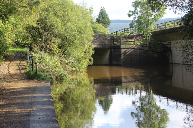
Nature enthusiasts will find plenty to explore in Aber-Garwed and its surroundings. The village is located near the Garw Valley Nature Reserve, which offers beautiful walking trails, abundant wildlife, and stunning scenery. The nearby Bwlch Mountain also provides breathtaking views of the area.
Despite its modest size, Aber-Garwed is well-connected to nearby towns and cities. It is within easy reach of Bridgend, which offers a wider range of amenities, including shopping centers, healthcare facilities, and leisure activities.
In summary, Aber-Garwed is a quaint village with a rich history and a strong sense of community. Its picturesque location and proximity to nature make it an appealing place to live for those seeking a peaceful and rural lifestyle.
If you have any feedback on the listing, please let us know in the comments section below.
Aber-Garwed Images
Images are sourced within 2km of 51.707063/-3.713672 or Grid Reference SN8102. Thanks to Geograph Open Source API. All images are credited.


Aber-Garwed is located at Grid Ref: SN8102 (Lat: 51.707063, Lng: -3.713672)
Unitary Authority: Neath Port Talbot
Police Authority: South Wales
Also known as: Abergarwed
What 3 Words
///cosmic.bunny.sardine. Near Resolven, Neath Port Talbot
Nearby Locations
Related Wikis

Abergarwed
Abergarwed is a village in the Welsh county borough of Neath Port Talbot, south Wales. It is located in the Vale of Neath, in the electoral ward of Resolven...
Melyncourt Halt railway station
Melyncourt Halt railway station co-served the village of Resolven, in the historical county of Glamorganshire, Wales, from 1905 to 1964 on the Vale of...

Melincourt Falls
Melincourt Falls is an 80 feet (24 m) high waterfall on Melin Court Brook, a left-bank tributary of the River Neath / Afon Nedd, located 1-mile (1.6 km...
Resolven
Resolven (Welsh: Resolfen) is a small village and community in Neath Port Talbot county borough, Wales. It is located in the Vale of Neath. == Location... ==
Resolven (electoral ward)
Resolven is and electoral ward of Neath Port Talbot county borough, Wales. Resolven is made up of the parishes of Resolven and Clyne and Melincourt. Resolven...
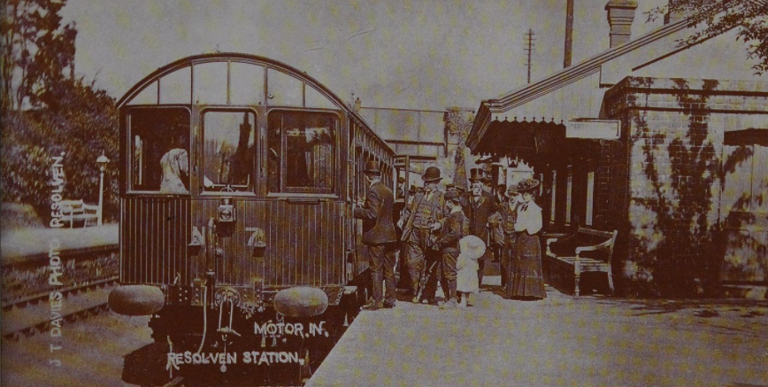
Resolven railway station
Resolven railway station served the village of Resolven, Neath Port Talbot, Wales, from 1851 to 1964 on the Vale of Neath Railway. == History == Construction...
Clyne, Neath Port Talbot
Clyne is a village in the Neath Port Talbot county borough, Wales, and is the main settlement in the community of Clyne and Melincourt which with the community...
Clyne Halt railway station
Clyne Halt railway station served the village of Clyne, in the historical county of Glamorganshire, Wales, from 1905 to 1964 on the Vale of Neath Railway...
Nearby Amenities
Located within 500m of 51.707063,-3.713672Have you been to Aber-Garwed?
Leave your review of Aber-Garwed below (or comments, questions and feedback).