Rowbrow Wood

Wood, Forest in Yorkshire Scarborough

England

Rowbrow Wood

Middle Road Track, Raincliffe Woods
Middle Road Track, Raincliffe Woods Credit: Ian S

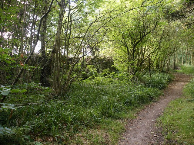
Rowbrow Wood is a picturesque woodland located in Yorkshire, England. Situated in the heart of the county, the wood covers an area of approximately 100 acres, making it a significant natural asset in the region. The woodland is characterized by a diverse range of tree species, including oak, birch, beech, and ash, creating a rich and vibrant ecosystem.

Rowbrow Wood is renowned for its stunning beauty, attracting nature enthusiasts, hikers, and photographers alike. The dense canopy of trees provides ample shade, making it an ideal spot for peaceful walks and picnics during the summer months. The forest floor is adorned with a colorful carpet of wildflowers, adding to the visual appeal of the wood.

The wood is home to a variety of wildlife, including deer, foxes, badgers, and numerous bird species. Birdwatchers can spot woodpeckers, owls, and various songbirds in their natural habitat. The tranquil atmosphere and abundance of wildlife make Rowbrow Wood a haven for nature lovers and a perfect spot for wildlife photography.

The wood is well-maintained and features a network of well-marked trails, allowing visitors to explore its beauty easily. Additionally, several benches and picnic areas are scattered throughout the wood, providing resting spots and panoramic views of the surrounding countryside.

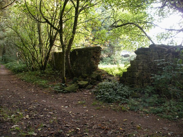
Rowbrow Wood is also of historical significance, with traces of ancient settlements and archaeological sites found within its boundaries. This adds an extra layer of interest for history enthusiasts and researchers.

Overall, Rowbrow Wood is a captivating woodland that offers a perfect blend of natural beauty, wildlife, and historical significance, making it a cherished gem in the landscape of Yorkshire.

If you have any feedback on the listing, please let us know in the comments section below.

Rowbrow Wood Images

Images are sourced within 2km of 54.274354/-0.44784072 or Grid Reference TA0187. Thanks to Geograph Open Source API. All images are credited.

Middle Road Track, Raincliffe Woods
Moor Lane, Irton Moor The road rises from East Ayton to Riggs Head.
Moor Lane, Irton Moor
The road rises from East Ayton to Riggs Head.
Lady Grace's Ride Bridleway in Raincliffe Woods.
Lady Grace's Ride
Bridleway in Raincliffe Woods.
Wood carving in Raincliffe Wood There were a few wood carvings in this area.
Wood carving in Raincliffe Wood
There were a few wood carvings in this area.
Another wood carving in Raincliffe Woods There were a few in this area.
Another wood carving in Raincliffe Woods
There were a few in this area.
Raincliffe Woods In the middle of Raincliffe Woods.
Raincliffe Woods
In the middle of Raincliffe Woods.
Owl carving An Owl carving in Raincliffe Woods.
Owl carving
An Owl carving in Raincliffe Woods.
Acorn carving An Acorn carving in Raincliffe Wood.
Acorn carving
An Acorn carving in Raincliffe Wood.
Roundhouse in Raincliffe Woods A mock-ancient roundhouse in Raincliffe Woods, to the side of Middle Road (track)
Roundhouse in Raincliffe Woods
A mock-ancient roundhouse in Raincliffe Woods, to the side of Middle Road (track)
Skell Dykes The tree lined embankment is the Skell Dykes which survive to an impressive height crossing arable land on East Ayton Moor. The dykes comprise two ditches and two banks and run south from the scarp edge for a distance of 660 metres though they originally continued southward into Seavegate Gill. The name probably comes from the Norse "Skial" meaning a boundary. Their precise date and use is unknown but along with the scarp slope of Forge Valley they would have enclosed a substantial area so are probably and land ownership feature.
Skell Dykes
The tree lined embankment is the Skell Dykes which survive to an impressive height crossing arable land on East Ayton Moor. The dykes comprise two ditches and two banks and run south from the scarp edge for a distance of 660 metres though they originally continued southward into Seavegate Gill. The name probably comes from the Norse "Skial" meaning a boundary. Their precise date and use is unknown but along with the scarp slope of Forge Valley they would have enclosed a substantial area so are probably and land ownership feature.
Sign on track to Osborne Lodge The sign on the gate across the track to Osborne Lodge is ambiguous. What it should really say is 'Public bridleway only. No public rights for motor vehicles'.
Sign on track to Osborne Lodge
The sign on the gate across the track to Osborne Lodge is ambiguous. What it should really say is 'Public bridleway only. No public rights for motor vehicles'.
Wilkinson's Shed Viewed from the public bridleway which runs along the top of the scarp slope of Raincliffe Woods is this dry stone wall structure. Although it is referred to as Wilkinson's Shed, it is probably a stock enclosure.
Wilkinson's Shed
Viewed from the public bridleway which runs along the top of the scarp slope of Raincliffe Woods is this dry stone wall structure. Although it is referred to as Wilkinson's Shed, it is probably a stock enclosure.
Wilkinson's Shed 2 Another view of Wikinson's Shed from the bridleway showing the construction of the wall which is too thin to be that of a shed. The likely use was a stock enclosure.
Wilkinson's Shed 2
Another view of Wikinson's Shed from the bridleway showing the construction of the wall which is too thin to be that of a shed. The likely use was a stock enclosure.
Tumulus, Seamer Moor Sitting within a large arable field is this Bronze Age burial mound of a type known as a bowl barrow. It still stands about 1.5 metres high. It is about 3,500 years old. A public footpath onto Seamer Moor (now all agricultural land) runs alongside the hedge
Tumulus, Seamer Moor
Sitting within a large arable field is this Bronze Age burial mound of a type known as a bowl barrow. It still stands about 1.5 metres high. It is about 3,500 years old. A public footpath onto Seamer Moor (now all agricultural land) runs alongside the hedge
Track, Raincliffe Woods The track, which is not a public right of way but part of the trails in Raincliffe Woods runs down the scarp slope through this cutting.
Track, Raincliffe Woods
The track, which is not a public right of way but part of the trails in Raincliffe Woods runs down the scarp slope through this cutting.
A  tree  lined  Stepney  Drive Junction with Stepney Grove on the right
A tree lined Stepney Drive
Junction with Stepney Grove on the right
Traffic  lights  on  A171  Scalby  Road  Scarborough Approaching Scarborough Hospital, behind trees on left
Traffic lights on A171 Scalby Road Scarborough
Approaching Scarborough Hospital, behind trees on left
Show me another place!

Rowbrow Wood is located at Grid Ref: TA0187 (Lat: 54.274354, Lng: -0.44784072)

Division: North Riding

Administrative County: North Yorkshire

District: Scarborough

Police Authority: North Yorkshire

What 3 Words

///dollar.anyway.times. Near East Ayton, North Yorkshire

Related Wikis

Graham School

Graham School is a coeducational secondary school in the west of Scarborough in North Yorkshire, England. It is situated to the west of the town within...
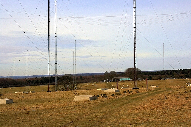
GCHQ Scarborough

GCHQ Scarborough is a satellite ground station located on Irton Moor, on the outskirts of Scarborough in North Yorkshire, England, operated by the British...

Scarborough Sixth Form College

Scarborough Sixth Form College is located on the outskirts of Scarborough, North Yorkshire, England. == Background == The Sixth form college offers a variety...

Raincliffe School

Raincliffe School was a comprehensive secondary school, with Business and Enterprise College status, in Scarborough, North Yorkshire, England. On 31 August...

Scarborough Hospital

Scarborough Hospital, formerly Scarborough General Hospital is an NHS district general hospital in Scarborough, North Yorkshire, England. It is run by...

Throxenby

Throxenby is a suburb of Scarborough, in North Yorkshire, England. Historically the settlement of Throxenby was a hamlet, separated from Scarborough by...

St Augustine's Catholic School

St Augustine's Catholic School is a co-educational secondary school located in Scarborough, North Yorkshire, England. The school is under the jurisdiction...

Scarborough TEC

Scarborough TEC, (formerly known as Yorkshire Coast College, Scarborough Technical College, Scarborough Technical Institute, and Scarborough School of...

Nearby Amenities

Located within 500m of 54.274354,-0.44784072
Man Made: mast
Lat/Long: 54.2775223/-0.4519819
The data included in this document is from www.openstreetmap.org. The data is made available under ODbL.

Have you been to Rowbrow Wood?

Leave your review of Rowbrow Wood below (or comments, questions and feedback).