Corby Pasture Wood

Wood, Forest in Lincolnshire South Kesteven

England

Corby Pasture Wood

Road Closure Road closed for the 783rd sheep fair.  On the left, the primary school.
Road Closure Credit: Bob Harvey

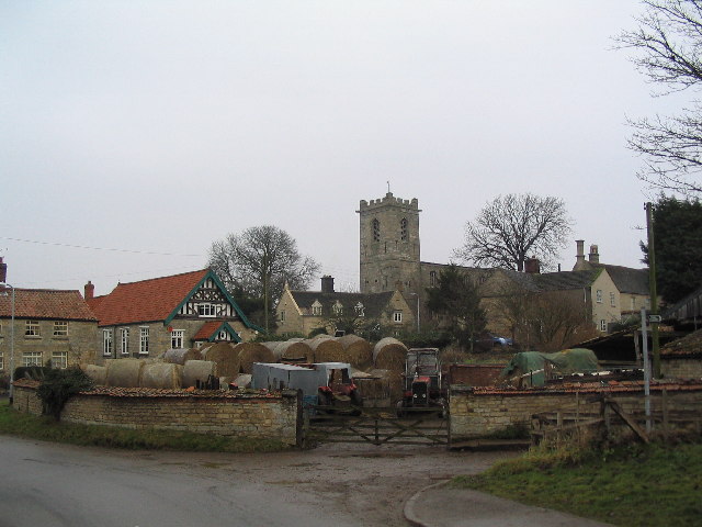
Corby Pasture Wood is a picturesque woodland located in Lincolnshire, England. Spanning over an area of approximately 100 acres, it is a captivating mix of ancient woodland and newer plantations. The woodland is situated near the town of Corby Glen, surrounded by the rolling countryside of Lincolnshire.

The wood boasts a rich diversity of flora and fauna, making it a haven for nature enthusiasts. Its ancient woodland contains a variety of tree species, including oak, ash, birch, and hazel, creating a dense canopy that filters sunlight and provides a cool, shady atmosphere. This environment supports a wide range of plants, including bluebells, primroses, and wood sorrel, which carpet the forest floor during springtime.

Corby Pasture Wood is also home to an abundance of wildlife. Visitors may spot different species of birds, such as woodpeckers, owls, and jays, while the woodland's mammal population includes foxes, badgers, and deer. Small mammals like voles, shrews, and bats can also be found here.

The wood offers a network of well-maintained footpaths, allowing visitors to explore its beauty at their own pace. There are picnic areas scattered throughout the woodland, providing a tranquil spot for families and individuals to enjoy a meal amidst nature.

The picturesque Corby Pasture Wood is a true gem in Lincolnshire, offering a serene and enchanting escape for those seeking solace in the beauty of nature.

If you have any feedback on the listing, please let us know in the comments section below.

Corby Pasture Wood Images

Images are sourced within 2km of 52.819036/-0.50354668 or Grid Reference TF0025. Thanks to Geograph Open Source API. All images are credited.

Road Closure Road closed for the 783rd sheep fair.  On the left, the primary school.
Road Closure
Road closed for the 783rd sheep fair. On the left, the primary school.
Stalls at the sheep fair A sheep burger stand, selling burgers made of hogget (chronologically between lamb and mutton); and the arts centre stall.
Stalls at the sheep fair
A sheep burger stand, selling burgers made of hogget (chronologically between lamb and mutton); and the arts centre stall.
The village school Dating from 1877 is the Primary School.
The village school
Dating from 1877 is the Primary School.
Datestone On the wall of <a href="https://www.geograph.org.uk/photo/6999259">SK9924 : The village school</a> a date stone from 1877.  School Boards were established as a consequence of the Elementary Education Act 1870, and the one for Corby Glen started teaching in the church and private homes while a rate was raised to pay for the building, most of which was actually funded by the Grimsthorpe estate, who still help run the establishment.
Datestone
On the wall of SK9924 : The village school a date stone from 1877. School Boards were established as a consequence of the Elementary Education Act 1870, and the one for Corby Glen started teaching in the church and private homes while a rate was raised to pay for the building, most of which was actually funded by the Grimsthorpe estate, who still help run the establishment.
Fire brigade at the Sheep Fair Corby Glen has a volunteer fire brigade, and here they were both taking part and fund raising at the sheep fair.
Fire brigade at the Sheep Fair
Corby Glen has a volunteer fire brigade, and here they were both taking part and fund raising at the sheep fair.
Gelston at the sheep fair Feeding the fairgoers.
Gelston at the sheep fair
Feeding the fairgoers.
Crowds at the sheep fair Around the performance stage at the sheep fair.
Crowds at the sheep fair
Around the performance stage at the sheep fair.
A pop-up cafe Outside the village cafe, a temporary extension for the sheep fair.
A pop-up cafe
Outside the village cafe, a temporary extension for the sheep fair.
Showman's Lorry One of the wagons that brought Dorman's funfair to the sheep fair.
Showman's Lorry
One of the wagons that brought Dorman's funfair to the sheep fair.
Solidarity with Ukraine A flag of Ukraine hung above the door of this house
Solidarity with Ukraine
A flag of Ukraine hung above the door of this house
The Village Flagpole The flagpole at Corby Glen is used to make a political statement from time to time. This time it is to side with the victims of Russian aggression in Ukraine, by flying the Ukrainian flag.
The Village Flagpole
The flagpole at Corby Glen is used to make a political statement from time to time. This time it is to side with the victims of Russian aggression in Ukraine, by flying the Ukrainian flag.
Station Road at the corner of Swinstead Road
Corby Road, Corby Glen
Church of St John the Evangelist, Corby Glen This contains several unusually well-preserved wall paintings
Church of St John the Evangelist, Corby Glen
This contains several unusually well-preserved wall paintings
Corby Glen Formerly just "Corby" ("Glen" was added in the 1950s to avoid confusion with Corby in Northamptonshire), this is a village full of character, see <span class="nowrap"><a title="http://www.corbyglen.com/fact.html" rel="nofollow ugc noopener" href="http://www.corbyglen.com/fact.html">Link</a><img style="margin-left:2px;" alt="External link" title="External link - shift click to open in new window" src="https://s1.geograph.org.uk/img/external.png" width="10" height="10"/></span>
Corby Glen
Formerly just "Corby" ("Glen" was added in the 1950s to avoid confusion with Corby in Northamptonshire), this is a village full of character, see LinkExternal link
The Lodge, Irnham Park
Irnham Hall Dating from Tudor period. Former manor was home of Sir Geoffrey Luttrell, who commissioned the famous Luttrell Psalter in 1340s
Irnham Hall
Dating from Tudor period. Former manor was home of Sir Geoffrey Luttrell, who commissioned the famous Luttrell Psalter in 1340s
The Griffin at Irnham Georgian pub at the heart of a small village which Sir Roy Strong selected as his 'favourite village in the Midlands'. See <span class="nowrap"><a title="http://www.countrylife.co.uk/lifecountry/irnham.php" rel="nofollow ugc noopener" href="http://www.countrylife.co.uk/lifecountry/irnham.php">Link</a><img style="margin-left:2px;" alt="External link" title="External link - shift click to open in new window" src="https://s1.geograph.org.uk/img/external.png" width="10" height="10"/></span>
The Griffin at Irnham
Georgian pub at the heart of a small village which Sir Roy Strong selected as his 'favourite village in the Midlands'. See LinkExternal link
Show me another place!

Corby Pasture Wood is located at Grid Ref: TF0025 (Lat: 52.819036, Lng: -0.50354668)

Administrative County: Lincolnshire

District: South Kesteven

Police Authority: Lincolnshire

What 3 Words

///dignitary.mystery.sunset. Near Corby Glen, Lincolnshire

Related Wikis

St John the Evangelist's Church, Corby Glen

The Church of St John the Evangelist is a Grade I listed Church of England parish church dedicated to John the Evangelist, in Corby Glen, Lincolnshire...

Corby Glen

Corby Glen is a village and civil parish in the South Kesteven district of Lincolnshire, England. It is approximately 9 miles (14 km) south-east of Grantham...

Charles Read Academy

Charles Read Academy is a co-educational secondary school located in Corby Glen, Lincolnshire, England. It serves the villages between Stamford, Bourne...

Northampton Sand Formation

The Northampton Sand Formation, sometimes called the Northamptonshire Sand, is a Middle Jurassic geological formation which is placed within the Inferior...

Nearby Amenities

Located within 500m of 52.819036,-0.50354668
Power: tower
Lat/Long: 52.8148954/-0.5027319
Power: tower
Lat/Long: 52.8162378/-0.506256
Power: tower
Lat/Long: 52.8175118/-0.509564
Cumberland Field
Place: locality
Source: Bing
Lat/Long: 52.8165219/-0.4976451
Irnham Grange
Place: farm
Source: Bing
Lat/Long: 52.8227359/-0.5029503
The data included in this document is from www.openstreetmap.org. The data is made available under ODbL.

Have you been to Corby Pasture Wood?

Leave your review of Corby Pasture Wood below (or comments, questions and feedback).