Round Wood

Wood, Forest in Oxfordshire South Oxfordshire

England

Round Wood

Woodland, Checkendon Beeches to the west of Checkendon Court.
Woodland, Checkendon Credit: Andrew Smith

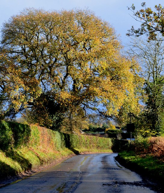
Round Wood is a picturesque woodland located in Oxfordshire, England. Situated near the village of Wood, it covers an area of approximately 200 acres and is a popular destination for nature enthusiasts and hikers alike.

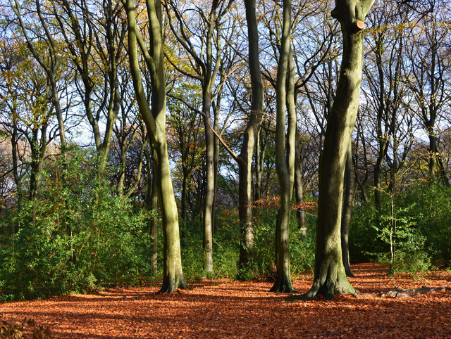
The woodland is characterized by its dense canopy of trees, predominantly consisting of oak, beech, and silver birch. The forest floor is covered in a thick carpet of vibrant green moss and ferns, creating a lush and serene atmosphere. The undergrowth is home to a diverse range of plant species, including bluebells, wild garlic, and foxgloves, which bloom in abundance during the spring and summer months.

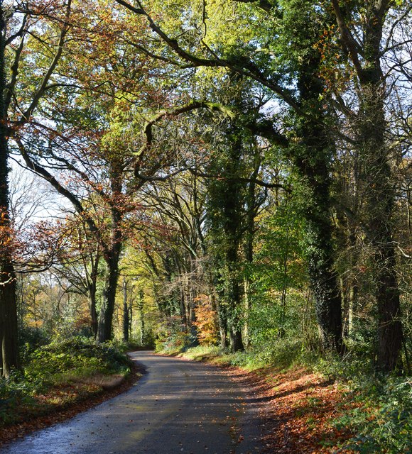
As visitors venture further into Round Wood, they will come across a network of well-maintained trails and footpaths that meander through the forest. These paths offer panoramic views of the surrounding countryside, with glimpses of rolling hills and open meadows. The wood is also intersected by a meandering stream, adding to its natural beauty.

Round Wood is not only a haven for flora but also provides a habitat for various animal species. Squirrels, rabbits, and a variety of bird species can be spotted throughout the woodland. In the evenings, owls can often be heard hooting in the distance, adding to the enchanting ambiance.

The woodland is managed by a local conservation trust, ensuring its preservation and providing educational programs for visitors. Additionally, there are picnic spots and benches scattered throughout the wood, allowing visitors to relax and immerse themselves in the tranquil surroundings.

Overall, Round Wood in Oxfordshire offers a serene and idyllic retreat for those seeking a peaceful escape amidst nature's beauty.

If you have any feedback on the listing, please let us know in the comments section below.

Round Wood Images

Images are sourced within 2km of 51.556887/-1.0390356 or Grid Reference SU6684. Thanks to Geograph Open Source API. All images are credited.

Woodland, Checkendon Beeches to the west of Checkendon Court.
Woodland, Checkendon
Beeches to the west of Checkendon Court.
Remains of the Polish Village After WW2 there were a lot of displaced Polish people who needed somewhere to live. Old military buildings provided accommodation for a Polish community here up until the 1960s.
Abandoned buildings from that time can still be seen in the woods.
History on <span class="nowrap"><a title="https://www.polishresettlementcampsintheuk.co.uk/checkendon.htm" rel="nofollow ugc noopener" href="https://www.polishresettlementcampsintheuk.co.uk/checkendon.htm">Link</a><img style="margin-left:2px;" alt="External link" title="External link - shift click to open in new window" src="https://s1.geograph.org.uk/img/external.png" width="10" height="10"/></span>
Remains of the Polish Village
After WW2 there were a lot of displaced Polish people who needed somewhere to live. Old military buildings provided accommodation for a Polish community here up until the 1960s. Abandoned buildings from that time can still be seen in the woods. History on LinkExternal link
Another Hut in the Woods Another one of the derelict buildings left over from WW2 which can still be seen in the woods round here. These were lived in up until the 1960s by community of Polish people displaced by the war.
History on <span class="nowrap"><a title="https://www.polishresettlementcampsintheuk.co.uk/checkendon.htm" rel="nofollow ugc noopener" href="https://www.polishresettlementcampsintheuk.co.uk/checkendon.htm">Link</a><img style="margin-left:2px;" alt="External link" title="External link - shift click to open in new window" src="https://s1.geograph.org.uk/img/external.png" width="10" height="10"/></span>
Another Hut in the Woods
Another one of the derelict buildings left over from WW2 which can still be seen in the woods round here. These were lived in up until the 1960s by community of Polish people displaced by the war. History on LinkExternal link
Stoke Row Green
Stoke Row Green
Stoke Row
Stoke Row
Houses in Stoke Row Looking towards Church View.
Houses in Stoke Row
Looking towards Church View.
Church View, Stoke Row
Kit Lane, Stoke Row
Kit Lane, Stoke Row
Pasture, Ipsden Paddocks at Well Place with Rowan Atkinson's house at Handsmooth not looking particularly attractive, but debatably not much worse than the one it replaced, in the background.
Pasture, Ipsden
Paddocks at Well Place with Rowan Atkinson's house at Handsmooth not looking particularly attractive, but debatably not much worse than the one it replaced, in the background.
Basset Wood
Basset Wood
Woods north east of Stoke Row
The Maharajah's Well, Stoke Row This is an unlikely looking structure to find in an Oxfordshire village. Its origins lie in the friendship that developed between Edward Anderton Reade, the son of a local squire who spent his working life in India, and the Maharajah of Benares. In Victorian times the villages of this part of Oxfordshire had only limited access to clean water bringing considerable hardship to the poor of the area. Learning of these difficulties, the Maharajah - who had remained loyal to the British during the Indian Mutiny of 1857 - determined that a charity should be set up to relieve the problem. The result was a well dug to a depth of 368 feet, a considerable engineering achievement. To honour the Maharajah, who never visited Britain, a splendid well canopy was built incorporating a gold elephant representing the Hindu god Ganesh. The well was used until the beginning of the Second World War although by that time most houses in the village had a mains connection. Today the well has been renovated and preserved and is maintained by the Maharajah's Well Trust.

The octagonal cottage to the right was built to house the well warden. The last warden died in 1979 since when it has been rented out to supplement the charity's income.
The Maharajah's Well, Stoke Row
This is an unlikely looking structure to find in an Oxfordshire village. Its origins lie in the friendship that developed between Edward Anderton Reade, the son of a local squire who spent his working life in India, and the Maharajah of Benares. In Victorian times the villages of this part of Oxfordshire had only limited access to clean water bringing considerable hardship to the poor of the area. Learning of these difficulties, the Maharajah - who had remained loyal to the British during the Indian Mutiny of 1857 - determined that a charity should be set up to relieve the problem. The result was a well dug to a depth of 368 feet, a considerable engineering achievement. To honour the Maharajah, who never visited Britain, a splendid well canopy was built incorporating a gold elephant representing the Hindu god Ganesh. The well was used until the beginning of the Second World War although by that time most houses in the village had a mains connection. Today the well has been renovated and preserved and is maintained by the Maharajah's Well Trust. The octagonal cottage to the right was built to house the well warden. The last warden died in 1979 since when it has been rented out to supplement the charity's income.
The Maharajah's Well, Stoke Row This is looking under the canopy of the well where the gold elephant takes pride of place. See <a href="https://www.geograph.org.uk/photo/7620533">SU6784 : The Maharajah's Well, Stoke Row</a> for a wider view and some historical notes.
The Maharajah's Well, Stoke Row
This is looking under the canopy of the well where the gold elephant takes pride of place. See SU6784 : The Maharajah's Well, Stoke Row for a wider view and some historical notes.
1 Langtree Cottages, Checkendon, Oxfordshire 1906 by Maxwell Ayrton in Arts and Crafts style. 

(Source:Historic England)
1 Langtree Cottages, Checkendon, Oxfordshire
1906 by Maxwell Ayrton in Arts and Crafts style. (Source:Historic England)
Foundry Cottage, Checkendon, Oxfordshire C17 with C20 windows. Brick ground floor with areas of flint; timber frame to first floor, rendered panels to left, brick infill to right. Old plain tile roof; brick stacks. 2-unit plan. 2-storey, 3-window range. Central 2-panel door with C20 gabled tile porch. 2-light casement to left. 2 single-light casements to right. Three 2-light casements to first floor. Roof hipped to right. Ridge stack to right and end stack to left.

(Source:Historic England)
Foundry Cottage, Checkendon, Oxfordshire
C17 with C20 windows. Brick ground floor with areas of flint; timber frame to first floor, rendered panels to left, brick infill to right. Old plain tile roof; brick stacks. 2-unit plan. 2-storey, 3-window range. Central 2-panel door with C20 gabled tile porch. 2-light casement to left. 2 single-light casements to right. Three 2-light casements to first floor. Roof hipped to right. Ridge stack to right and end stack to left. (Source:Historic England)
After rain, Stoke Row, Oxfordshire
Beech woodland, Stoke Row, Oxfordshire
Country lane, Ipsden, Oxfordshire
Show me another place!

Round Wood is located at Grid Ref: SU6684 (Lat: 51.556887, Lng: -1.0390356)

Administrative County: Oxfordshire

District: South Oxfordshire

Police Authority: Thames Valley

What 3 Words

///reflector.unions.remaining. Near Rotherfield Peppard, Oxfordshire

Related Wikis

Ipsden Heath

Ipsden Heath is a 32-acre (13-hectare) woodland in the English county of Oxfordshire, within the Chiltern Area of Outstanding Natural Beauty. == References ==

Checkendon

Checkendon is a village and civil parish about 6 miles (10 km) west of Henley-on-Thames in South Oxfordshire and about 9 miles (14 km) north west of Reading...

St Peter and St Paul, Checkendon

St Peter and St Paul is the Church of England parish church of Checkendon, a village in Oxfordshire, England. Its parish is part of the Deanery of Henley...

Stoke Row

Stoke Row is a village and civil parish in the Chiltern Hills, about 5 miles (8 km) west of Henley-on-Thames in South Oxfordshire and about 9 miles (14...

Warren Bank

Warren Bank is a 3.1-hectare (7.7-acre) biological Site of Special Scientific Interest south-east of Wallingford in Oxfordshire. It is managed by the Berkshire...

Henley Rural District

Henley was a rural district in Oxfordshire, England from 1894 to 1974.It was named after the borough of Henley-on-Thames, which it surrounded on the west...

Wyfold Court

Wyfold Court is a country house at Rotherfield Peppard in south Oxfordshire. It is a Grade II* listed building. By the year 2000, the estate had been converted...

Nuffield, Oxfordshire

Nuffield is a village and civil parish in the Chiltern Hills in South Oxfordshire, England, just over 4 miles (6 km) east of Wallingford. The 2011 Census...

Nearby Amenities

Located within 500m of 51.556887,-1.0390356
Created By: osmeditor2
Lat/Long: 51.5585359/-1.0402178
Created By: osmeditor2
Lat/Long: 51.5568207/-1.0381412
Created By: osmeditor2
Lat/Long: 51.5545778/-1.0364134
Created By: osmeditor2
Lat/Long: 51.5608293/-1.0411894
Created By: osmeditor2
Lat/Long: 51.5601375/-1.0412051
Created By: osmeditor2
Lat/Long: 51.5596647/-1.0410316
Created By: osmeditor2
Lat/Long: 51.5591886/-1.0406799
Power: pole
Lat/Long: 51.5584549/-1.0391656
Power: pole
Lat/Long: 51.5584432/-1.0385379
Power: pole
Lat/Long: 51.5584366/-1.0380042
Power: pole
Lat/Long: 51.5592136/-1.0377118
Power: pole
Transformer: distribution
Lat/Long: 51.5584232/-1.037465
Power: pole
Lat/Long: 51.5568357/-1.0370305
Power: pole
Lat/Long: 51.5559518/-1.0367516
Power: pole
Lat/Long: 51.5553615/-1.0364351
Power: pole
Lat/Long: 51.5546343/-1.0360891
Power: pole
Lat/Long: 51.5541991/-1.0430601
Power: pole
Lat/Long: 51.5537388/-1.0420355
Power: pole
Lat/Long: 51.5532818/-1.0411263
Power: pole
Lat/Long: 51.552573/-1.0402063
Direction: 215
Fixme: survey for panel count
Generator Method: photovoltaic
Generator Output Electricity: yes
Generator Solar Modules: 10
Generator Source: solar
Generator Type: solar_photovoltaic_panel
Location: roof
Power: generator
Lat/Long: 51.5542984/-1.0362037
Direction: 295
Fixme: survey for panel count
Generator Method: photovoltaic
Generator Output Electricity: yes
Generator Solar Modules: 6
Generator Source: solar
Generator Type: solar_photovoltaic_panel
Location: roof
Power: generator
Lat/Long: 51.5542849/-1.0362044
The data included in this document is from www.openstreetmap.org. The data is made available under ODbL.

Have you been to Round Wood?

Leave your review of Round Wood below (or comments, questions and feedback).