Breach Wood

Wood, Forest in Oxfordshire South Oxfordshire

England

Breach Wood

Woodland, Checkendon Beeches to the west of Checkendon Court.
Woodland, Checkendon Credit: Andrew Smith

Breach Wood is a picturesque woodland located in Oxfordshire, England. Covering an area of approximately 100 acres, it is a popular destination for nature enthusiasts and outdoor lovers alike. The wood is nestled within the larger Wychwood Forest, renowned for its beauty and biodiversity.

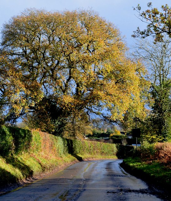
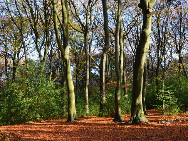
The woodland is characterized by its dense canopy of mature trees, predominantly consisting of oak, beech, and birch. These towering trees provide a tranquil and shady environment, making it an ideal spot for visitors to seek refuge from the summer heat or simply enjoy a peaceful walk. The forest floor is carpeted with a diverse range of flora, including bluebells, wild garlic, and wood anemones, creating a stunning display of colors during the spring months.

Breach Wood is home to a variety of wildlife, making it a haven for nature enthusiasts and wildlife photographers. It is not uncommon to spot species such as red kites, buzzards, and woodpeckers while exploring the woodland. Additionally, the wood provides habitat for mammals like deer, foxes, and badgers, which can sometimes be spotted at dawn or dusk.

The wood is crisscrossed by a network of well-maintained footpaths and trails, allowing visitors to explore its beauty at their own pace. These paths lead visitors through a diverse range of habitats, including open meadows, babbling brooks, and secluded ponds. There are also picnic areas dotted throughout the woodland, providing an opportunity for visitors to relax and enjoy the tranquility of the surroundings.

In summary, Breach Wood is a captivating woodland in Oxfordshire, offering a peaceful and scenic retreat from the hustle and bustle of everyday life. Its rich biodiversity, well-maintained trails, and stunning natural beauty make it a must-visit destination for nature enthusiasts and those seeking a connection with the great outdoors.

If you have any feedback on the listing, please let us know in the comments section below.

Breach Wood Images

Images are sourced within 2km of 51.552184/-1.0367981 or Grid Reference SU6684. Thanks to Geograph Open Source API. All images are credited.

Woodland, Checkendon Beeches to the west of Checkendon Court.
Woodland, Checkendon
Beeches to the west of Checkendon Court.
Remains of the Polish Village After WW2 there were a lot of displaced Polish people who needed somewhere to live. Old military buildings provided accommodation for a Polish community here up until the 1960s.
Abandoned buildings from that time can still be seen in the woods.
History on <span class="nowrap"><a title="https://www.polishresettlementcampsintheuk.co.uk/checkendon.htm" rel="nofollow ugc noopener" href="https://www.polishresettlementcampsintheuk.co.uk/checkendon.htm">Link</a><img style="margin-left:2px;" alt="External link" title="External link - shift click to open in new window" src="https://s1.geograph.org.uk/img/external.png" width="10" height="10"/></span>
Remains of the Polish Village
After WW2 there were a lot of displaced Polish people who needed somewhere to live. Old military buildings provided accommodation for a Polish community here up until the 1960s. Abandoned buildings from that time can still be seen in the woods. History on LinkExternal link
Another Hut in the Woods Another one of the derelict buildings left over from WW2 which can still be seen in the woods round here. These were lived in up until the 1960s by community of Polish people displaced by the war.
History on <span class="nowrap"><a title="https://www.polishresettlementcampsintheuk.co.uk/checkendon.htm" rel="nofollow ugc noopener" href="https://www.polishresettlementcampsintheuk.co.uk/checkendon.htm">Link</a><img style="margin-left:2px;" alt="External link" title="External link - shift click to open in new window" src="https://s1.geograph.org.uk/img/external.png" width="10" height="10"/></span>
Another Hut in the Woods
Another one of the derelict buildings left over from WW2 which can still be seen in the woods round here. These were lived in up until the 1960s by community of Polish people displaced by the war. History on LinkExternal link
Stoke Row The road becomes Kit Lane but the maps don't give a name till beyond the end of the village.
Stoke Row
The road becomes Kit Lane but the maps don't give a name till beyond the end of the village.
Stoke Row Green
Stoke Row Green
Stoke Row
Stoke Row
Houses in Stoke Row Looking towards Church View.
Houses in Stoke Row
Looking towards Church View.
Church View, Stoke Row
Kit Lane, Stoke Row
Kit Lane, Stoke Row
Pasture, Ipsden Paddocks at Well Place with Rowan Atkinson's house at Handsmooth not looking particularly attractive, but debatably not much worse than the one it replaced, in the background.
Pasture, Ipsden
Paddocks at Well Place with Rowan Atkinson's house at Handsmooth not looking particularly attractive, but debatably not much worse than the one it replaced, in the background.
Basset Wood
Basset Wood
Woods north east of Stoke Row
The Maharajah's Well, Stoke Row This is an unlikely looking structure to find in an Oxfordshire village. Its origins lie in the friendship that developed between Edward Anderton Reade, the son of a local squire who spent his working life in India, and the Maharajah of Benares. In Victorian times the villages of this part of Oxfordshire had only limited access to clean water bringing considerable hardship to the poor of the area. Learning of these difficulties, the Maharajah - who had remained loyal to the British during the Indian Mutiny of 1857 - determined that a charity should be set up to relieve the problem. The result was a well dug to a depth of 368 feet, a considerable engineering achievement. To honour the Maharajah, who never visited Britain, a splendid well canopy was built incorporating a gold elephant representing the Hindu god Ganesh. The well was used until the beginning of the Second World War although by that time most houses in the village had a mains connection. Today the well has been renovated and preserved and is maintained by the Maharajah's Well Trust.

The octagonal cottage to the right was built to house the well warden. The last warden died in 1979 since when it has been rented out to supplement the charity's income.
The Maharajah's Well, Stoke Row
This is an unlikely looking structure to find in an Oxfordshire village. Its origins lie in the friendship that developed between Edward Anderton Reade, the son of a local squire who spent his working life in India, and the Maharajah of Benares. In Victorian times the villages of this part of Oxfordshire had only limited access to clean water bringing considerable hardship to the poor of the area. Learning of these difficulties, the Maharajah - who had remained loyal to the British during the Indian Mutiny of 1857 - determined that a charity should be set up to relieve the problem. The result was a well dug to a depth of 368 feet, a considerable engineering achievement. To honour the Maharajah, who never visited Britain, a splendid well canopy was built incorporating a gold elephant representing the Hindu god Ganesh. The well was used until the beginning of the Second World War although by that time most houses in the village had a mains connection. Today the well has been renovated and preserved and is maintained by the Maharajah's Well Trust. The octagonal cottage to the right was built to house the well warden. The last warden died in 1979 since when it has been rented out to supplement the charity's income.
The Maharajah's Well, Stoke Row This is looking under the canopy of the well where the gold elephant takes pride of place. See <a href="https://www.geograph.org.uk/photo/7620533">SU6784 : The Maharajah's Well, Stoke Row</a> for a wider view and some historical notes.
The Maharajah's Well, Stoke Row
This is looking under the canopy of the well where the gold elephant takes pride of place. See SU6784 : The Maharajah's Well, Stoke Row for a wider view and some historical notes.
1 Langtree Cottages, Checkendon, Oxfordshire 1906 by Maxwell Ayrton in Arts and Crafts style. 

(Source:Historic England)
1 Langtree Cottages, Checkendon, Oxfordshire
1906 by Maxwell Ayrton in Arts and Crafts style. (Source:Historic England)
Foundry Cottage, Checkendon, Oxfordshire C17 with C20 windows. Brick ground floor with areas of flint; timber frame to first floor, rendered panels to left, brick infill to right. Old plain tile roof; brick stacks. 2-unit plan. 2-storey, 3-window range. Central 2-panel door with C20 gabled tile porch. 2-light casement to left. 2 single-light casements to right. Three 2-light casements to first floor. Roof hipped to right. Ridge stack to right and end stack to left.

(Source:Historic England)
Foundry Cottage, Checkendon, Oxfordshire
C17 with C20 windows. Brick ground floor with areas of flint; timber frame to first floor, rendered panels to left, brick infill to right. Old plain tile roof; brick stacks. 2-unit plan. 2-storey, 3-window range. Central 2-panel door with C20 gabled tile porch. 2-light casement to left. 2 single-light casements to right. Three 2-light casements to first floor. Roof hipped to right. Ridge stack to right and end stack to left. (Source:Historic England)
After rain, Stoke Row, Oxfordshire
Beech woodland, Stoke Row, Oxfordshire
Show me another place!

Breach Wood is located at Grid Ref: SU6684 (Lat: 51.552184, Lng: -1.0367981)

Administrative County: Oxfordshire

District: South Oxfordshire

Police Authority: Thames Valley

What 3 Words

///professes.early.flexibly. Near Rotherfield Peppard, Oxfordshire

Related Wikis

Ipsden Heath

Ipsden Heath is a 32-acre (13-hectare) woodland in the English county of Oxfordshire, within the Chiltern Area of Outstanding Natural Beauty. == References ==

Checkendon

Checkendon is a village and civil parish about 6 miles (10 km) west of Henley-on-Thames in South Oxfordshire and about 9 miles (14 km) north west of Reading...

St Peter and St Paul, Checkendon

St Peter and St Paul is the Church of England parish church of Checkendon, a village in Oxfordshire, England. Its parish is part of the Deanery of Henley...

Stoke Row

Stoke Row is a village and civil parish in the Chiltern Hills, about 5 miles (8 km) west of Henley-on-Thames in South Oxfordshire and about 9 miles (14...

Warren Bank

Warren Bank is a 3.1-hectare (7.7-acre) biological Site of Special Scientific Interest south-east of Wallingford in Oxfordshire. It is managed by the Berkshire...

Wyfold Court

Wyfold Court is a country house at Rotherfield Peppard in south Oxfordshire. It is a Grade II* listed building. By the year 2000, the estate had been converted...

Henley Rural District

Henley was a rural district in Oxfordshire, England from 1894 to 1974.It was named after the borough of Henley-on-Thames, which it surrounded on the west...

Exlade Street

Exlade Street is a hamlet in Checkendon civil parish in Oxfordshire, about 6 miles (9.7 km) northwest of Reading, in the Chiltern Hills. The hamlet is...

Nearby Amenities

Located within 500m of 51.552184,-1.0367981
Created By: osmeditor2
Lat/Long: 51.5517822/-1.0331836
Created By: osmeditor2
Lat/Long: 51.5499117/-1.0343683
Created By: osmeditor2
Lat/Long: 51.5522946/-1.0326355
Created By: osmeditor2
Lat/Long: 51.5545778/-1.0364134
Pub
The Black Horse
Addr City: Checkendon
Addr Postcode: RG8 0TE
Addr Street: Burncote Lane
Email: margaret.morgan8@btinternet.com
Opening Hours: Mo-Sa 12:00-14:00,19:00-23:00; Su 12:00-15:00,19:00-23:00; Winter Su 12:00-15:00
Phone: +44 1491 680418
Source: https://whatpub.com/pubs/SOX/0140/black-horse-checkendon
Website: https://www.facebook.com/p/The-Black-Horse-Checkendon-100057645571594/
Lat/Long: 51.551268/-1.0398871
Post Box
Post Box Type: lamp
Royal Cypher: EIIR
Royal Cypher Wikidata: Q33102113
Source: survey
Lat/Long: 51.5528935/-1.0316718
Barrier: kissing_gate
Bicycle: no
Foot: yes
Lat/Long: 51.5494198/-1.0424205
Barrier: kissing_gate
Foot: yes
Lat/Long: 51.5481362/-1.0363952
Barrier: stile
Foot: yes
Material: wood
Stile: stepover
Lat/Long: 51.5510877/-1.0386777
Barrier: stile
Foot: yes
Material: wood
Stile: stepover
Lat/Long: 51.5503662/-1.0342706
Barrier: stile
Foot: yes
Material: wood
Stile: stepover
Lat/Long: 51.5506129/-1.0340101
Barrier: stile
Foot: yes
Material: wood
Stile: stepover
Lat/Long: 51.5504205/-1.0335223
Power: pole
Lat/Long: 51.5559518/-1.0367516
Power: pole
Lat/Long: 51.5553615/-1.0364351
Power: pole
Lat/Long: 51.5546343/-1.0360891
Power: pole
Lat/Long: 51.5541991/-1.0430601
Power: pole
Lat/Long: 51.5537388/-1.0420355
Power: pole
Lat/Long: 51.5532818/-1.0411263
Power: pole
Lat/Long: 51.552573/-1.0402063
Power: pole
Lat/Long: 51.5517791/-1.039238
Power: pole
Lat/Long: 51.5510286/-1.0382992
Power: pole
Lat/Long: 51.5505966/-1.0373095
Power: pole
Lat/Long: 51.5500412/-1.0361025
Power: pole
Lat/Long: 51.5495175/-1.0349035
Power: pole
Lat/Long: 51.5498911/-1.0355821
Power: pole
Lat/Long: 51.5505182/-1.0352308
Power: pole
Lat/Long: 51.5511087/-1.0344315
Power: pole
Lat/Long: 51.551619/-1.0337046
Information: guidepost
Tourism: information
Lat/Long: 51.5529541/-1.0318072
Direction: 215
Fixme: survey for panel count
Generator Method: photovoltaic
Generator Output Electricity: yes
Generator Solar Modules: 10
Generator Source: solar
Generator Type: solar_photovoltaic_panel
Location: roof
Power: generator
Lat/Long: 51.5542984/-1.0362037
Direction: 295
Fixme: survey for panel count
Generator Method: photovoltaic
Generator Output Electricity: yes
Generator Solar Modules: 6
Generator Source: solar
Generator Type: solar_photovoltaic_panel
Location: roof
Power: generator
Lat/Long: 51.5542849/-1.0362044
Fixme: solar panels?
Lat/Long: 51.5525369/-1.0315941
The data included in this document is from www.openstreetmap.org. The data is made available under ODbL.

Have you been to Breach Wood?

Leave your review of Breach Wood below (or comments, questions and feedback).