Borders Wood

Wood, Forest in Nottinghamshire Rushcliffe

England

Borders Wood

Aleacia's Rest, Cotgrave Forest I have failed to find any reference to this, so it remains an enigma.
Aleacia's Rest, Cotgrave Forest Credit: Alan Murray-Rust

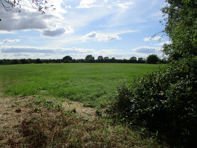
Borders Wood is a picturesque forest located in Nottinghamshire, England. Covering an area of approximately 50 acres, this woodland is nestled on the border between Nottinghamshire and Derbyshire, hence its name. It is situated within close proximity to the popular tourist destination of the Peak District National Park, making it an ideal spot for nature lovers and outdoor enthusiasts.

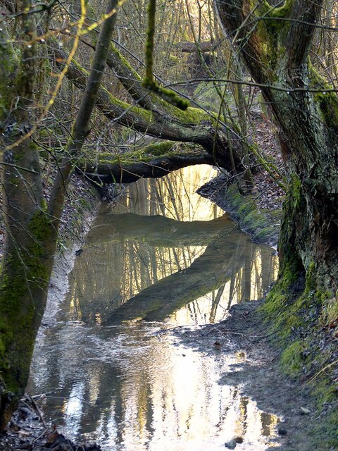
The wood is known for its diverse range of flora and fauna, offering a haven for wildlife. The forest is primarily composed of broadleaf trees, such as oak, beech, and birch, which create a dense canopy that provides shade and shelter. The forest floor is adorned with a variety of wildflowers and ferns, adding bursts of color to the landscape.

Several walking trails meander through Borders Wood, offering visitors the opportunity to explore its natural beauty. These paths are well-maintained and suitable for all ages and abilities. Along the trails, visitors may come across small streams and ponds, adding to the tranquility of the surroundings.

The woodland is home to a rich array of wildlife, including deer, foxes, badgers, and a wide range of bird species. Birdwatchers can spot woodpeckers, owls, and various songbirds in the forest's canopy.

Borders Wood also offers recreational facilities, such as picnic areas and benches, where visitors can relax and enjoy the serene atmosphere. The forest is open to the public throughout the year, with no admission fee, making it an accessible destination for both locals and tourists.

Overall, Borders Wood is a stunning natural retreat that provides an escape from the hustle and bustle of city life, offering visitors the chance to immerse themselves in the beauty of Nottinghamshire's woodlands.

If you have any feedback on the listing, please let us know in the comments section below.

Borders Wood Images

Images are sourced within 2km of 52.89145/-1.0188743 or Grid Reference SK6633. Thanks to Geograph Open Source API. All images are credited.

Aleacia's Rest, Cotgrave Forest I have failed to find any reference to this, so it remains an enigma.
Aleacia's Rest, Cotgrave Forest
I have failed to find any reference to this, so it remains an enigma.
Power lines through Cotgrave Forest My recollection is that the gate did not exist when I last passed this way in 2011 <a title="https://www.geograph.org.uk/photo/2667630" href="https://www.geograph.org.uk/photo/2667630">Link</a> . There is an interesting sign <a title="https://www.geograph.org.uk/photo/7074163" href="https://www.geograph.org.uk/photo/7074163">Link</a> attached to the gate.
Power lines through Cotgrave Forest
My recollection is that the gate did not exist when I last passed this way in 2011 Link . There is an interesting sign Link attached to the gate.
Stream in Cotgrave Forest This runs down from the forest to Normanton on the Wolds.
Stream in Cotgrave Forest
This runs down from the forest to Normanton on the Wolds.
Catkins in Cotgrave Forest As always a harbinger of spring.
Catkins in Cotgrave Forest
As always a harbinger of spring.
Bridleway junction in Cotgrave Forest Left is Wolds Lane to Clipston, part of the Notts Wolds Way; right leads to Cotgrave. The woodland has developed considerably since I passed this way in 2011 <a title="https://www.geograph.org.uk/photo/2667606" href="https://www.geograph.org.uk/photo/2667606">Link</a>
Bridleway junction in Cotgrave Forest
Left is Wolds Lane to Clipston, part of the Notts Wolds Way; right leads to Cotgrave. The woodland has developed considerably since I passed this way in 2011 Link
Digger in the fields It was being used more to distribute the sludge being brought to the field <a title="https://www.geograph.org.uk/photo/7074594" href="https://www.geograph.org.uk/photo/7074594">Link</a> than to excavate anything.
Digger in the fields
It was being used more to distribute the sludge being brought to the field Link than to excavate anything.
Farmland off Laming Gap Lane Recreating this 'First' for the square <a title="https://www.geograph.org.uk/photo/185841" href="https://www.geograph.org.uk/photo/185841">Link</a>
Farmland off Laming Gap Lane
Recreating this 'First' for the square Link
Right angle bend in Laming Gap Lane At this point the lane is joined from the left by Wolds Lane from Clipston. Here there is an unofficial parking area for access to Cotgrave Forest, although the white pick-up was associated with the digger seen in this view <a title="https://www.geograph.org.uk/photo/7074174" href="https://www.geograph.org.uk/photo/7074174">Link</a> . Wolds Lane and this part of Laming Gap Lane form part of the Notts Wolds Way long distance path.
Right angle bend in Laming Gap Lane
At this point the lane is joined from the left by Wolds Lane from Clipston. Here there is an unofficial parking area for access to Cotgrave Forest, although the white pick-up was associated with the digger seen in this view Link . Wolds Lane and this part of Laming Gap Lane form part of the Notts Wolds Way long distance path.
View from Laming Gap Lane In the distance are lorries on the A46.
View from Laming Gap Lane
In the distance are lorries on the A46.
Delivering sludge See <a title="https://www.geograph.org.uk/photo/7074174" href="https://www.geograph.org.uk/photo/7074174">Link</a> for more information.
Delivering sludge
See Link for more information.
Grass field by the Fosse Way near Cotgrave
Former road to Owthorpe This is now reduced to the status of a bridleway and provides access to Wolds Farm. The road was diverted when the A46 was dualled.
Former road to Owthorpe
This is now reduced to the status of a bridleway and provides access to Wolds Farm. The road was diverted when the A46 was dualled.
Road sign at the top of the bank Seen from the former road to Owthorpe.
Road sign at the top of the bank
Seen from the former road to Owthorpe.
Farm track near Cotgrave
Grass field at the top of Wolds Hill
Overgrown settling pond This pond is designated 4A and receives run-off from the A46.
Overgrown settling pond
This pond is designated 4A and receives run-off from the A46.
Vimy Ridge Farm perhaps named after that infamous ridge from WWI
Vimy Ridge Farm
perhaps named after that infamous ridge from WWI
Chestnut Tree on Kinoulton Lane looks like it will be a good season for konkers
Chestnut Tree on Kinoulton Lane
looks like it will be a good season for konkers
Show me another place!

Borders Wood is located at Grid Ref: SK6633 (Lat: 52.89145, Lng: -1.0188743)

Administrative County: Nottinghamshire

District: Rushcliffe

Police Authority: Nottinghamshire

What 3 Words

///broached.paths.package. Near Cotgrave, Nottinghamshire

Related Wikis

Owthorpe

Owthorpe is a small English village and civil parish in the Wolds of the East Midland county of Nottinghamshire. The population of about 90 was included...

St Margaret's Church, Owthorpe

St Margaret's Church, Owthorpe is a Grade II* listed parish church in the Church of England in Owthorpe, Nottinghamshire, England. Owthorpe has an unusual...

Scunthorpe Mudstone

The Scunthorpe Mudstone is a geologic formation in England. It preserves plesiosaur fossils dating back to the Late Triassic (Rhaetian) to Early Jurassic...

Rushcliffe

Rushcliffe is a local government district with borough status in south Nottinghamshire, England. Its council is based in West Bridgford. The borough also...

Clipston, Nottinghamshire

Clipston, or Clipston on the Wolds, is a small English village and civil parish in the south Nottinghamshire district of Rushcliffe. It lies between Cotgrave...

All Saints' Church, Cotgrave

All Saints’ Church is a Grade I listed Church of England parish church in the Diocese of Southwell and Nottingham in Cotgrave. == History == The church...

St Luke's Church, Kinoulton

St Luke's Church, Kinoulton is a Grade II* listed parish church in the Church of England in Kinoulton. == History == The church dates from 1793 and was...

Cotgrave

Cotgrave () is a town and civil parish in the borough of Rushcliffe in Nottinghamshire, England, some 5 miles (8 km) south-east of central Nottingham....

Nearby Amenities

Located within 500m of 52.89145,-1.0188743
Passing Place
Source: gps;survey
Lat/Long: 52.8919/-1.0247559
Passing Place
Source: gps;survey
Lat/Long: 52.8936502/-1.0245153
Power: pole
Source: Bing
Lat/Long: 52.8944445/-1.02102
Power: pole
Source: Bing
Lat/Long: 52.8939513/-1.0224046
Power: pole
Source: Bing
Lat/Long: 52.8949202/-1.0196521
Power: pole
Source: Bing
Lat/Long: 52.8952795/-1.0179837
Material: wood
Power: pole
Source: Bing
Lat/Long: 52.8932568/-1.024759
Borders Wood Shooting Ground
Sport: shooting
Website: https://www.borderswood.co.uk/
Lat/Long: 52.8871577/-1.0196163
Crossing
Crossing: uncontrolled
Lat/Long: 52.8907265/-1.0141502
Barrier: block
Material: stone
Lat/Long: 52.8954364/-1.0161066
Barrier: block
Material: stone
Lat/Long: 52.8954209/-1.016064
Barrier: block
Material: stone
Lat/Long: 52.8954083/-1.0160319
Barrier: block
Material: stone
Lat/Long: 52.8953935/-1.0160004
Barrier: block
Material: stone
Lat/Long: 52.8953854/-1.015963
Power: pole
Lat/Long: 52.8898255/-1.0147079
The data included in this document is from www.openstreetmap.org. The data is made available under ODbL.

Have you been to Borders Wood?

Leave your review of Borders Wood below (or comments, questions and feedback).