Captain's Gorse
Wood, Forest in Berkshire
England
Captain's Gorse
Captain's Gorse is a woodland area located in Berkshire, England. It is situated within the larger Bracknell Forest, which covers an area of approximately 4,900 acres. The woodland is named after a local notable, Captain William Henry Ewing Gorse, who owned the land in the early 20th century.
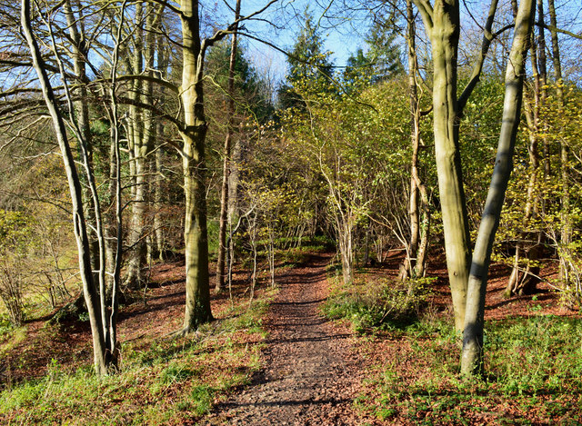
Covering an area of around 50 acres, Captain's Gorse is predominantly made up of dense deciduous trees, including oak, beech, and birch. The woodland is characterized by its undulating terrain, with some sections being fairly flat while others feature gentle slopes. This variation in topography adds to the charm and beauty of the area.
Visitors to Captain's Gorse can enjoy a variety of outdoor activities. The woodland is crisscrossed by a network of footpaths and trails, providing opportunities for walking, jogging, and cycling. Birdwatchers may also be delighted by the diverse range of avian species that inhabit the woodland, including woodpeckers, owls, and various songbirds.
In addition to its natural beauty, Captain's Gorse also holds historical significance. The woodland contains remnants of old structures and boundaries, dating back to when the land was used for agricultural purposes centuries ago. These remnants serve as a reminder of the area's rich heritage and add an element of intrigue for history enthusiasts.
Overall, Captain's Gorse in Berkshire offers a tranquil escape from the hustle and bustle of urban life. Whether it's for leisurely walks amidst nature, exploring the history of the land, or simply enjoying the peaceful ambiance, this woodland is a delightful destination for individuals seeking solace in the beauty of the natural world.
If you have any feedback on the listing, please let us know in the comments section below.
Captain's Gorse Images
Images are sourced within 2km of 51.479527/-1.1577635 or Grid Reference SU5875. Thanks to Geograph Open Source API. All images are credited.


Captain's Gorse is located at Grid Ref: SU5875 (Lat: 51.479527, Lng: -1.1577635)
Unitary Authority: West Berkshire
Police Authority: Thames Valley
What 3 Words
///unopposed.deny.butter. Near Upper Basildon, Berkshire
Nearby Locations
Related Wikis

Upper Basildon
Upper Basildon is a small village in the civil parish of Basildon (where the United Kingdom 2011 Census population is included), near to Pangbourne, in...

Ashampstead Common
Ashampstead Common is a common in the English county of Berkshire, within the civil parish of Ashampstead. The common lies north of the M4 motorway, near...

St Andrew's School, Pangbourne
St Andrew's School is an independent preparatory school in the hamlet of Buckhold, near Pangbourne, Berkshire, England. Together with its 'Pre-Prep – Early...
Basildon, Berkshire
Basildon is a civil parish in the English county of Berkshire. It comprises the small villages of Upper Basildon and Lower Basildon, named for their respective...

Burnt Hill, Berkshire
Burnt Hill is a hamlet in Berkshire, England. It is just north of the M4 motorway in West Berkshire, in the civil parish of Yattendon, which is also the...

Ashampstead
Ashampstead is a small village and civil parish in the rural area between Reading, Newbury and Streatley in Berkshire, England. The parish population is...

Basildon Park
Basildon Park is a country house situated 2 miles (3 kilometres) south of Goring-on-Thames and Streatley in Berkshire, between the villages of Upper Basildon...
Yattendon
Yattendon is a village and civil parish 7 miles (11 km) northeast of Newbury in the county of Berkshire, England. The M4 motorway passes through the fields...
Nearby Amenities
Located within 500m of 51.479527,-1.1577635Have you been to Captain's Gorse?
Leave your review of Captain's Gorse below (or comments, questions and feedback).