Gravelhill Plantation
Wood, Forest in Berkshire
England
Gravelhill Plantation
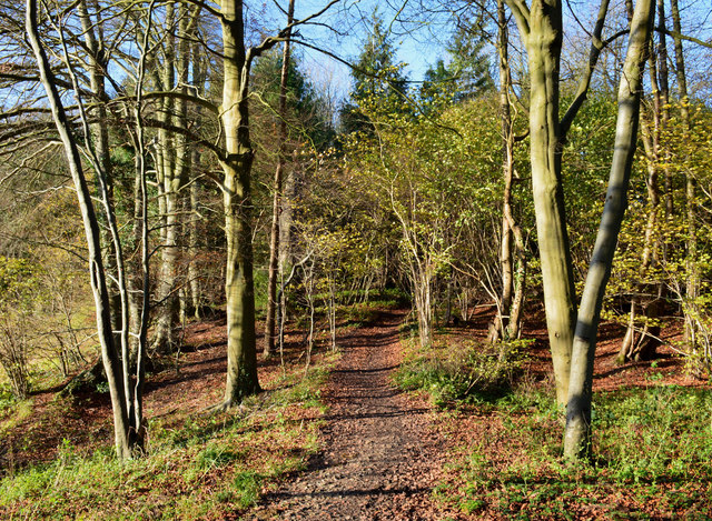
Gravelhill Plantation is a picturesque woodland located in Berkshire, England. Spanning across a vast area of lush greenery, this plantation is known for its dense forests and natural beauty. It is situated in close proximity to the town of Wood, making it easily accessible for nature enthusiasts and tourists alike.
The plantation boasts a diverse range of flora and fauna, with numerous species of trees such as oak, beech, and pine dominating the landscape. These tall, majestic trees provide shelter and a habitat for various wildlife species, including deer, rabbits, squirrels, and a wide variety of birds.
Gravelhill Plantation offers several walking trails and paths, allowing visitors to explore the enchanting woodland and immerse themselves in nature. The trails are well-maintained and signposted, ensuring a safe and enjoyable experience for all. Along these paths, visitors can discover hidden ponds and streams, providing a tranquil setting for relaxation and contemplation.
The plantation also offers various recreational activities for visitors. There are designated picnic areas where families and friends can gather and enjoy a leisurely meal amidst the serene surroundings. Additionally, the plantation serves as a popular spot for birdwatching and photography enthusiasts, offering ample opportunities to capture stunning images of the local wildlife and natural landscapes.
Gravelhill Plantation, Berkshire, is a true haven for nature lovers seeking solace and tranquility amidst the beauty of the natural world. Its diverse ecosystem and well-preserved woodlands make it a must-visit destination for those wishing to immerse themselves in the wonders of nature.
If you have any feedback on the listing, please let us know in the comments section below.
Gravelhill Plantation Images
Images are sourced within 2km of 51.475485/-1.1571324 or Grid Reference SU5875. Thanks to Geograph Open Source API. All images are credited.


Gravelhill Plantation is located at Grid Ref: SU5875 (Lat: 51.475485, Lng: -1.1571324)
Unitary Authority: West Berkshire
Police Authority: Thames Valley
What 3 Words
///saying.eyeliner.hairspray. Near Upper Basildon, Berkshire
Nearby Locations
Related Wikis

Ashampstead Common
Ashampstead Common is a common in the English county of Berkshire, within the civil parish of Ashampstead. The common lies north of the M4 motorway, near...

Upper Basildon
Upper Basildon is a small village in the civil parish of Basildon (where the United Kingdom 2011 Census population is included), near to Pangbourne, in...

St Andrew's School, Pangbourne
St Andrew's School is an independent preparatory school in the hamlet of Buckhold, near Pangbourne, Berkshire, England. Together with its 'Pre-Prep – Early...

Burnt Hill, Berkshire
Burnt Hill is a hamlet in Berkshire, England. It is just north of the M4 motorway in West Berkshire, in the civil parish of Yattendon, which is also the...
Basildon, Berkshire
Basildon is a civil parish in the English county of Berkshire. It comprises the small villages of Upper Basildon and Lower Basildon, named for their respective...

Ashampstead
Ashampstead is a small village and civil parish in the rural area between Reading, Newbury and Streatley in Berkshire, England. The parish population is...
Bradfield Rural District
Bradfield was a rural district in Berkshire, England, from 1894 to 1974.It was created under the Local Government Act 1894 from the Bradfield rural sanitary...
Yattendon
Yattendon is a village and civil parish 7 miles (11 km) northeast of Newbury in the county of Berkshire, England. The M4 motorway passes through the fields...
Nearby Amenities
Located within 500m of 51.475485,-1.1571324Have you been to Gravelhill Plantation?
Leave your review of Gravelhill Plantation below (or comments, questions and feedback).