Beech Copse

Wood, Forest in Hampshire

England

Beech Copse

Central IOW from St Catherine's Hill A good view over the middle of the island from up here on the southern edge.
Central IOW from St Catherine's Hill Credit: Des Blenkinsopp

Beech Copse is a beautiful woodland located in Hampshire, England. Covering an area of approximately 50 acres, it is characterized by its dense beech trees, creating a stunning canopy that stretches as far as the eye can see. The copse is situated within the South Downs National Park, adding to its natural beauty and providing a haven for wildlife.

As one explores Beech Copse, they will be surrounded by a peaceful and tranquil atmosphere. The woodland floor is covered in a thick carpet of fallen leaves, creating a soft and cushioned pathway. The beech trees stand tall and majestic, their branches intertwining to create a lush green roof that filters the sunlight, casting an ethereal glow throughout the copse.

The diverse ecosystem of Beech Copse is home to a wide variety of flora and fauna. Wildflowers such as bluebells, primroses, and wood anemones bloom in abundance during the spring, painting the forest floor with vibrant colors. The woodland is also teeming with wildlife, including deer, squirrels, foxes, and a multitude of bird species, making it a popular spot for birdwatchers and nature enthusiasts.

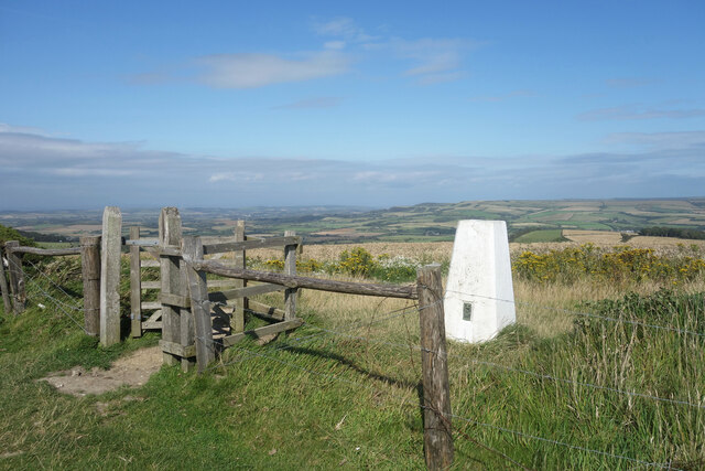
Beech Copse offers a range of recreational activities for visitors to enjoy. There are numerous walking trails that crisscross through the woodland, allowing visitors to explore its hidden corners and discover its natural treasures. The copse is also a popular spot for picnics and family outings, providing a serene and picturesque backdrop for a day in nature.

In summary, Beech Copse is a captivating woodland in Hampshire, boasting a dense canopy of beech trees, a diverse array of flora and fauna, and a tranquil ambiance. It is a place of natural beauty and a sanctuary for wildlife, offering visitors a chance to immerse themselves in the wonders of nature.

If you have any feedback on the listing, please let us know in the comments section below.

Beech Copse Images

Images are sourced within 2km of 50.599421/-1.283552 or Grid Reference SZ5077. Thanks to Geograph Open Source API. All images are credited.

Central IOW from St Catherine's Hill A good view over the middle of the island from up here on the southern edge.
Central IOW from St Catherine's Hill
A good view over the middle of the island from up here on the southern edge.
Old lighthouse in the way Construction of a lighthouse on top of St Catherine's Hill started in the 1780's but was soon abandoned because the site was so often foggy.
When they came to put up a radio mast on the same site, they had to work around the base of the old tower.
Old lighthouse in the way
Construction of a lighthouse on top of St Catherine's Hill started in the 1780's but was soon abandoned because the site was so often foggy. When they came to put up a radio mast on the same site, they had to work around the base of the old tower.
Crops on St Catherine's Hill The edge of the access land around St Catherine's Oratory. Beyond is farmland to the horizon.
Crops on St Catherine's Hill
The edge of the access land around St Catherine's Oratory. Beyond is farmland to the horizon.
Chalk Grassland, Niton Down Home to a great diversity of plants and creatures, chalk grassland is often a preserved habitat.
Chalk Grassland, Niton Down
Home to a great diversity of plants and creatures, chalk grassland is often a preserved habitat.
St Catherine's Oratory, Isle of Wight Looking along the south-west coast of the island
St Catherine's Oratory, Isle of Wight
Looking along the south-west coast of the island
St. Catherine's Oratory Locally known as the Pepperpot. Dating from about 1320, it was erected by Walter de Godeton as an act of penance for plundering wine from the wreck of St. Marie of Bayonne in Chale Bay.
St. Catherine's Oratory
Locally known as the Pepperpot. Dating from about 1320, it was erected by Walter de Godeton as an act of penance for plundering wine from the wreck of St. Marie of Bayonne in Chale Bay.
Blackgang Chine from A3055 This is a ravine 400ft deep, a wild place in the 19C but now filled by a theme park.  Alexander Dabell started a scenic garden in 1842 and opened it in 1845 to attract the increasing numbers of tourists.  The chine is now much shorter than it was in the mid-19C, such is the speed of erosion on this coast.  The site now includes 35 acres on the clifftop.
Blackgang Chine from A3055
This is a ravine 400ft deep, a wild place in the 19C but now filled by a theme park. Alexander Dabell started a scenic garden in 1842 and opened it in 1845 to attract the increasing numbers of tourists. The chine is now much shorter than it was in the mid-19C, such is the speed of erosion on this coast. The site now includes 35 acres on the clifftop.
Hoy's Monument Viewed from the south. On the northern face it reads:-

    In commemoration of the visit
                 of 
His Imperial Majesty Alexander the 1st
     Emperor of all the Russias
  to Great Britain in the year 1814 
 In remembrance of many happy Years 
     Residence in his Dominions
            This Pillar 
           was erected by
            Michael Hoy

On the southern face it reads 

   This tablet was erected by
      William Henry Dawes
Late Lieutenant of H.M. 22nd Reg
 In honour of those brave men of
      the allied armies
    who fell on the Alma
        at Inkermann
and at the siege of Sevastapol
          A.D. 1857
see <a href="https://www.geograph.org.uk/photo/781861">SZ4978 : Hoy Monument Plaque</a> and <a href="https://www.geograph.org.uk/photo/781870">SZ4978 : Plaque on the North Face of the Hoy Monument</a>
Hoy's Monument
Viewed from the south. On the northern face it reads:- In commemoration of the visit of His Imperial Majesty Alexander the 1st Emperor of all the Russias to Great Britain in the year 1814 In remembrance of many happy Years Residence in his Dominions This Pillar was erected by Michael Hoy On the southern face it reads This tablet was erected by William Henry Dawes Late Lieutenant of H.M. 22nd Reg In honour of those brave men of the allied armies who fell on the Alma at Inkermann and at the siege of Sevastapol A.D. 1857 see SZ4978 : Hoy Monument Plaque and SZ4978 : Plaque on the North Face of the Hoy Monument
Trig Point on St Catherine's Hill Close to St. Catherine's Oratory, a tumulus, and a modern transmitter. Looking north along the ridge towards the Hoy Monument.
Trig Point on St Catherine's Hill
Close to St. Catherine's Oratory, a tumulus, and a modern transmitter. Looking north along the ridge towards the Hoy Monument.
Transmitter Tower and St Catherine's Oratory Within a few hundred yards of each other we have a Bronze Age Tumulus, a Medieval Lighthouse, possibly the base of a windmill??, a trig point and the modern transmitter.
Transmitter Tower and St Catherine's Oratory
Within a few hundred yards of each other we have a Bronze Age Tumulus, a Medieval Lighthouse, possibly the base of a windmill??, a trig point and the modern transmitter.
Base of Old Lighthouse on St Catherine's Hill Begun in 1785 but abandoned before it was finished because the frequent fog at the site made it useless. Known as the mustard pot or the salt cellar (to go with St Catherine's tower being the pepperpot)
Base of Old Lighthouse on St Catherine's Hill
Begun in 1785 but abandoned before it was finished because the frequent fog at the site made it useless. Known as the mustard pot or the salt cellar (to go with St Catherine's tower being the pepperpot)
Tumulus near St Catherine's Oratory and Trig Point Looking north from near the base of the transmitter.
Tumulus near St Catherine's Oratory and Trig Point
Looking north from near the base of the transmitter.
Near Hermitage Dairy Farm A bridleway climbs the north-west shoulder of St. Catherine's Down towards Hoy's monument.  It is constrained by this fence and beyond are some of the many pastures of Hermitage Dairy Farm.
Near Hermitage Dairy Farm
A bridleway climbs the north-west shoulder of St. Catherine's Down towards Hoy's monument. It is constrained by this fence and beyond are some of the many pastures of Hermitage Dairy Farm.
Copse near Hermitage Dairy From the road to the Hermitage looking south towards an un-named copse marked on the 1:25K map.  Although it's near the dairy, this is sheep pasture.
Copse near Hermitage Dairy
From the road to the Hermitage looking south towards an un-named copse marked on the 1:25K map. Although it's near the dairy, this is sheep pasture.
Terrace with a view These sheep seem oblivious to the extensive view across the east of the island from their terrace.  A couple are checking out the photographer though.
Terrace with a view
These sheep seem oblivious to the extensive view across the east of the island from their terrace. A couple are checking out the photographer though.
Entrance to The Hermitage Public entrance on the right.  Tradesmen's entrance on the left.  Footpath round the back of the estate to the left by the stone wall.  The Hermitage is the remotest Country House on the Isle of Wight, now a luxury (5-star) bed and breakfast.  Originally the home of Michael Hoy a successful 18th century trader, who also built the nearby Hoy monument to commemorate the visit of the Russian Tsar.
Entrance to The Hermitage
Public entrance on the right. Tradesmen's entrance on the left. Footpath round the back of the estate to the left by the stone wall. The Hermitage is the remotest Country House on the Isle of Wight, now a luxury (5-star) bed and breakfast. Originally the home of Michael Hoy a successful 18th century trader, who also built the nearby Hoy monument to commemorate the visit of the Russian Tsar.
Cottage near the Hermitage An estate cottage for the Hermitage.  The country house itself is hidden in the woodland behind this cottage.
Cottage near the Hermitage
An estate cottage for the Hermitage. The country house itself is hidden in the woodland behind this cottage.
Stile and trig point on St Catherine's Hill On the left the painted-white triangulation pillar on St Catherine's Hill, and in the foreground a stile leading to the footpath on the left of the fence. At the hill summit is the base of an old lighthouse and a modern telecoms mast and associated buildings. It is raining.
Stile and trig point on St Catherine's Hill
On the left the painted-white triangulation pillar on St Catherine's Hill, and in the foreground a stile leading to the footpath on the left of the fence. At the hill summit is the base of an old lighthouse and a modern telecoms mast and associated buildings. It is raining.
Show me another place!

Beech Copse is located at Grid Ref: SZ5077 (Lat: 50.599421, Lng: -1.283552)

Unitary Authority: Isle of Wight

Police Authority: Hampshire

What 3 Words

///slipping.bitter.video. Near Niton, Isle of Wight

Related Wikis

A3055 road

The A3055 is an A-Class Road on the Isle of Wight in Southern England. It forms the Southern portion of the circular around-the-Island A-class loop, the...

Bierley, Isle of Wight

Bierley is a hamlet on the Isle of Wight, UK. Bierley is in the south of the Isle of Wight, north of Niton and 0.7 miles to the west of Whitwell. Bierley...

Church of St John the Baptist, Niton

The Church of St John the Baptist, Niton is a Church of England parish church in Niton, Isle of Wight. == History == The church was founded by William...

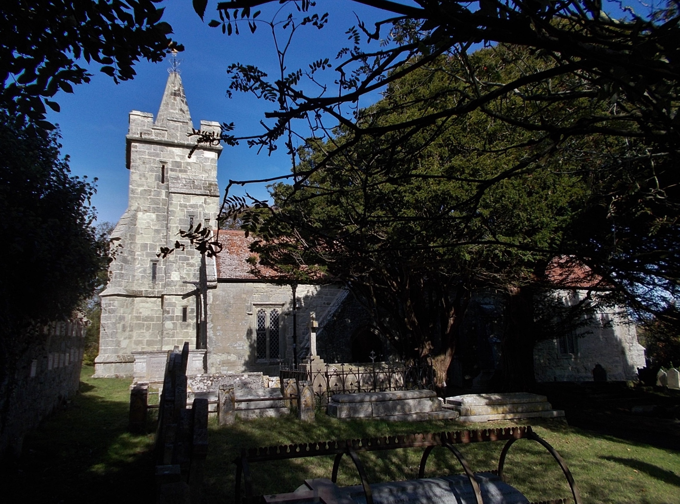
Church of St Mary and St Radegund, Whitwell

The Church of St. Mary and St. Radegund, Whitwell is a parish church in the Church of England located in Whitwell on the Isle of Wight. == History == The...

Niton

Niton is a village and former civil parish, now in the parish of Niton and Whitwell, on the Isle of Wight, England. It is west of Ventnor, with a population...

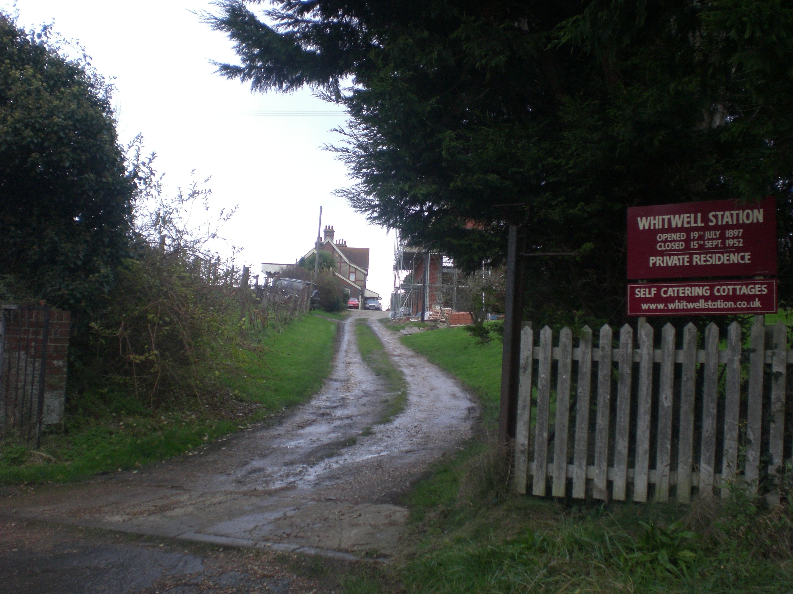
Whitwell Halt railway station

Whitwell Station, on the Ventnor West branch of the Isle of Wight Central Railway, was opened on 20 July 1897 along with the other stations on the branch...

Whitwell, Isle of Wight

Whitwell is a small village and former civil parish, now in the parish of Niton and Whitwell, on the south of the Isle of Wight, England, approximately...

St Catherine's Oratory

St. Catherine's Oratory is a medieval lighthouse on St. Catherine's Down, above the southern coast of the Isle of Wight. It was built by Lord of Chale...

Nearby Amenities

Located within 500m of 50.599421,-1.283552
Source: Locally rectified NPE map
Lat/Long: 50.6007441/-1.2801856
Source: Locally rectified NPE map
Lat/Long: 50.602903/-1.2842346
Barrier: stile
Lat/Long: 50.5990487/-1.2767459
Source: Bing
Lat/Long: 50.5977291/-1.2896511
Source: Locally rectified NPE map
Lat/Long: 50.5965647/-1.2796746
Source: Bing
Lat/Long: 50.5969576/-1.2887791
Bus Stop
Kingates Barn
Bus: yes
Naptan AtcoCode: 230000006710
Naptan Bearing: S
Naptan CommonName: Kingates Barn
Naptan Indicator: towards Niton
Naptan NaptanCode: iowgagw
Public Transport: platform
Shelter: no
Lat/Long: 50.598042/-1.2791485
Bus Stop
Bierley
Bus: yes
Naptan AtcoCode: 230000007470
Naptan Bearing: S
Naptan CommonName: Bierley
Naptan Indicator: towards Niton
Naptan NaptanCode: iowgdtp
Public Transport: platform
Shelter: no
Lat/Long: 50.6013829/-1.2796361
Bus Stop
Bierley
Bench: no
Bin: no
Bus: yes
Naptan AtcoCode: 230000007480
Naptan Bearing: N
Naptan CommonName: Bierley
Naptan Indicator: towards Newport
Naptan NaptanCode: iowgdtw
Public Transport: platform
Shelter: no
Lat/Long: 50.6010199/-1.2801228
Source: Bing
Lat/Long: 50.5998293/-1.2802192
Source: Bing
Lat/Long: 50.5986176/-1.2847639
Source: Bing
Lat/Long: 50.5984623/-1.2853021
Source: Bing
Lat/Long: 50.5980234/-1.2882828
Source: Bing
Lat/Long: 50.5987559/-1.2900932
Source: Bing
Lat/Long: 50.5983405/-1.2897687
Post Box
Operator: Royal Mail
Operator Wikidata: Q638098
Post Box Mounting: wooden_post
Post Box Type: lamp
Ref: PO38 245
Ref GB Uprn: 10015274139
Website: https://www.royalmail.com/services-near-you/postbox/kingates-po38-2ba/000PO38245
Lat/Long: 50.5972443/-1.2793283
Source: Bing
Lat/Long: 50.5970174/-1.2893112
Source: Bing
Lat/Long: 50.5967401/-1.2885836
Source: Bing
Lat/Long: 50.5971362/-1.2895545
Source: Bing
Lat/Long: 50.5978592/-1.2898025
Bierley
Place: hamlet
Source: survey
Wikidata: Q4904610
Wikipedia: en:Bierley, Isle of Wight
Lat/Long: 50.60062/-1.2796943
Kingates
Place: hamlet
Source: survey
Lat/Long: 50.5975819/-1.2800571
Waterway: waterfall
Lat/Long: 50.6018774/-1.2830678
Head Down
Place: locality
Source: os_opendata_streetview
Lat/Long: 50.5969185/-1.2877314
Downsview
Internet Access: wlan
Operator: Motorhome and Caravan Club CL
Tourism: camp_site
Lat/Long: 50.5996012/-1.27796
Barrier: stile
Lat/Long: 50.5969183/-1.2887458
Bus Stop
Kingates Barn
Bus: yes
Naptan AtcoCode: 230000117
Naptan NaptanCode: iowmpwa
Public Transport: platform
Survey Date: 2021-02-24
Lat/Long: 50.5979844/-1.2792927
Source: Bing
Lat/Long: 50.5978017/-1.2895973
Source: Bing
Lat/Long: 50.5978727/-1.2896199
Barrier: stile
Lat/Long: 50.5977654/-1.2896242
Barrier: stile
Lat/Long: 50.5978058/-1.2895667
Bench
Lat/Long: 50.5958148/-1.2799515
Parking
Parking: layby
Lat/Long: 50.5958676/-1.279918
Power: substation
Lat/Long: 50.5965035/-1.2798321
Addr Housename: Southend
Lat/Long: 50.5975421/-1.2797369
Barrier: kissing_gate
Lat/Long: 50.6007851/-1.2802322
The data included in this document is from www.openstreetmap.org. The data is made available under ODbL.

Have you been to Beech Copse?

Leave your review of Beech Copse below (or comments, questions and feedback).