Drayton

Settlement in Norfolk Broadland

England

Drayton

Old Milestone, Drayton On the South side of the A1067, 20yds W of junction with Taverham Road, in the parish of Drayton. Alternative views are <a href="https://www.geograph.org.uk/photo/1391707">TG1713 : Drayton Milestone</a> & <a href="https://www.geograph.org.uk/photo/1558894">TG1713 : Old Milepost</a>.

Inscription: To / Norwich / 4 / Miles // Fakenham / 20 // Drayton

Milestone Society National ID: NO_NF04
Old Milestone, Drayton Credit: Alan Lake

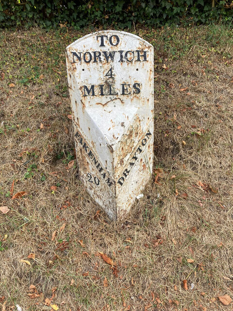
Drayton is a small village located in the county of Norfolk, England. Situated about 4 miles northwest of Norwich, it falls within the district of Broadland. The village is surrounded by picturesque countryside, offering a tranquil and scenic setting for its residents.

With a population of around 8,000 people, Drayton retains a close-knit community feel. The village is well-served by local amenities, including a primary school, a library, a medical center, and several shops and restaurants. There are also various recreational facilities available, such as a community center and sports fields, which contribute to the village's vibrant social life.

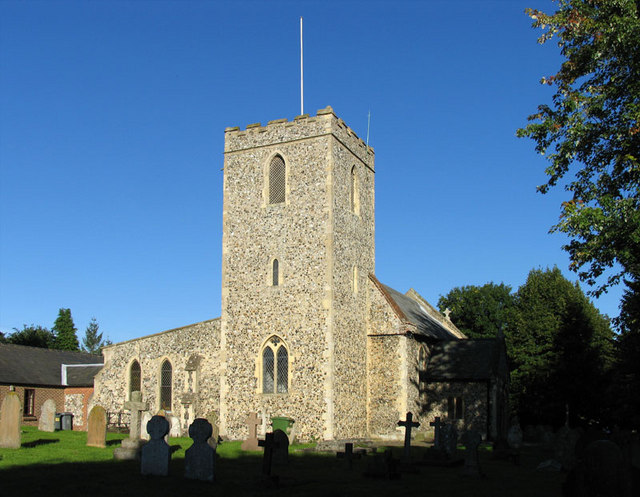
Drayton boasts a rich history, with evidence of human settlement dating back to the Roman era. The village features a number of historic buildings, including St. Margaret's Church, which dates back to the 12th century and is known for its impressive stained glass windows. The surrounding area offers opportunities for outdoor activities, with nearby woodlands and nature reserves providing ample space for walking, cycling, and exploring the local flora and fauna.

Transport links in Drayton are excellent, with regular bus services connecting the village to Norwich city center and other nearby towns. The village also benefits from easy access to major roads, including the A47, which connects Drayton to other parts of Norfolk and beyond.

In summary, Drayton is a charming village in Norfolk, England, offering a peaceful and friendly environment, a range of amenities, and a rich historical heritage.

If you have any feedback on the listing, please let us know in the comments section below.

Drayton Images

Images are sourced within 2km of 52.676021/1.223407 or Grid Reference TG1813. Thanks to Geograph Open Source API. All images are credited.

Old Milestone, Drayton On the South side of the A1067, 20yds W of junction with Taverham Road, in the parish of Drayton. Alternative views are <a href="https://www.geograph.org.uk/photo/1391707">TG1713 : Drayton Milestone</a> & <a href="https://www.geograph.org.uk/photo/1558894">TG1713 : Old Milepost</a>.

Inscription: To / Norwich / 4 / Miles // Fakenham / 20 // Drayton

Milestone Society National ID: NO_NF04
Old Milestone, Drayton
On the South side of the A1067, 20yds W of junction with Taverham Road, in the parish of Drayton. Alternative views are TG1713 : Drayton Milestone & TG1713 : Old Milepost. Inscription: To / Norwich / 4 / Miles // Fakenham / 20 // Drayton Milestone Society National ID: NO_NF04
Bridge Cottage, River Wensum, Costessey Nestling close to the river and the site of an old Toll Bridge, this cottage would have been the toll keeper's residence. The bridge looks to have been collecting tolls as late as 1905, run by a private company. It was not part of the turnpike system and would originally obviated some turnpike miles to Norwich.

Milestone Society National ID: NO.COS
Bridge Cottage, River Wensum, Costessey
Nestling close to the river and the site of an old Toll Bridge, this cottage would have been the toll keeper's residence. The bridge looks to have been collecting tolls as late as 1905, run by a private company. It was not part of the turnpike system and would originally obviated some turnpike miles to Norwich. Milestone Society National ID: NO.COS
Barber, baker and beautician, Drayton On Taverham Road.
Barber, baker and beautician, Drayton
On Taverham Road.
Oops a Daisy, Drayton Florist on Fakenham Road.
Oops a Daisy, Drayton
Florist on Fakenham Road.
Village sign, Drayton Commemorating 50 years since the founding of Drayton 'afternoon W I'.
Village sign, Drayton
Commemorating 50 years since the founding of Drayton 'afternoon W I'.
The Red Lion public house, Drayton The building dates from 1678, becoming an inn in the mid 1700s. Damaged by enemy action in 1942.
The Red Lion public house, Drayton
The building dates from 1678, becoming an inn in the mid 1700s. Damaged by enemy action in 1942.
The Cock Inn, Drayton The present building replaced an 18th century inn in 1956. It was renovated  in 1998-1999. One of the Marston chain of brewers.
The Cock Inn, Drayton
The present building replaced an 18th century inn in 1956. It was renovated in 1998-1999. One of the Marston chain of brewers.
Children's play area, Drayton Playground on School Road, next to St. Margaret's church which can be seen in the background.
Children's play area, Drayton
Playground on School Road, next to St. Margaret's church which can be seen in the background.
St. Margaret's church, Drayton The church dates from 1198 with some medieval fabric but mainly rebuilt in the 19th century. Inside is a fragment of the 15th century rood screen stair by the pulpit.  Grade II* listed.
St. Margaret's church, Drayton
The church dates from 1198 with some medieval fabric but mainly rebuilt in the 19th century. Inside is a fragment of the 15th century rood screen stair by the pulpit. Grade II* listed.
Inside St. Margaret's church, Drayton Looking eastwards along the nave. The church dates from 1198 with some medieval fabric but mainly rebuilt in the 19th century. A fragment of the 15th century rood screen stair can be seen by the pulpit. A Grade II* listed building.
Inside St. Margaret's church, Drayton
Looking eastwards along the nave. The church dates from 1198 with some medieval fabric but mainly rebuilt in the 19th century. A fragment of the 15th century rood screen stair can be seen by the pulpit. A Grade II* listed building.
A poppyhead in St. Margaret's church, Drayton A poppyhead is a form of carving on the top of the end of a bench or a choir stall. Its name is unrelated to the poppy flower but derived by way of Old French, from the Latin word puppis, which means the poop or the figurehead of a ship.
A poppyhead in St. Margaret's church, Drayton
A poppyhead is a form of carving on the top of the end of a bench or a choir stall. Its name is unrelated to the poppy flower but derived by way of Old French, from the Latin word puppis, which means the poop or the figurehead of a ship.
East window, St. Margaret's church, Drayton The church dates from 1198 with some medieval fabric but mainly rebuilt in the 19th century.  A Grade II* listed building.
East window, St. Margaret's church, Drayton
The church dates from 1198 with some medieval fabric but mainly rebuilt in the 19th century. A Grade II* listed building.
18th century gravestone, St. Margaret's church, Drayton A child's grave, John, son of John and Elizabeth Cannell, who died in 1781 in the 6th year of his age.
18th century gravestone, St. Margaret's church, Drayton
A child's grave, John, son of John and Elizabeth Cannell, who died in 1781 in the 6th year of his age.
18th century gravestone, St. Margaret's church, Drayton A detail on a child's grave, John, son of John and Elizabeth Cannell, who died in 1781 in the 6th year of his age.
18th century gravestone, St. Margaret's church, Drayton
A detail on a child's grave, John, son of John and Elizabeth Cannell, who died in 1781 in the 6th year of his age.
Old Milepost by the A1067, Drayton High Road, Drayton Cast iron post by the A1067, in parish of DRAYTON (BROADLAND District), 150yds East of junction with Hurn Road. Just East of entrance to former David Rice Hospital, on the verge, near lamppost, on South side of road. Fakenham ci l-top, erected by the Norwich & Fakenham turnpike trust in the 19th century. An earlier photograph can be found here <a title="https://www.geograph.org.uk/photo/6617195" href="https://www.geograph.org.uk/photo/6617195">Link</a>.

Inscription reads:- : TO / FAKENHAM / 21 : : TO / NORWICH / 3 : : DRAYTON :

Listed.

Milestone Society National ID: NO_NF03.
Old Milepost by the A1067, Drayton High Road, Drayton
Cast iron post by the A1067, in parish of DRAYTON (BROADLAND District), 150yds East of junction with Hurn Road. Just East of entrance to former David Rice Hospital, on the verge, near lamppost, on South side of road. Fakenham ci l-top, erected by the Norwich & Fakenham turnpike trust in the 19th century. An earlier photograph can be found here Link. Inscription reads:- : TO / FAKENHAM / 21 : : TO / NORWICH / 3 : : DRAYTON : Listed. Milestone Society National ID: NO_NF03.
Old Milepost by the A1067, Fakenham Road, Taverham Cast iron post by the A1067, in parish of Taverham (Broadland District), Fakenham Road, opposite No. 230, on the verge at rear of footpath against hedge, on West side of road. Fakenham ci n-top, erected by the Norwich & Fakenham turnpike trust in the 19th century. 

Inscription reads:-
: FAKENHAM / 19 : : TO NORWICH / 5 / MILES : : TAVERHAM / 5 :

Norfolk HER.
NHER Number: 56411 <span class="nowrap"><a title="https://www.heritagegateway.org.uk/Gateway/Results_Single.aspx?uid=MNF62817&resourceID=1002" rel="nofollow ugc noopener" href="https://www.heritagegateway.org.uk/Gateway/Results_Single.aspx?uid=MNF62817&resourceID=1002">Link</a><img style="margin-left:2px;" alt="External link" title="External link - shift click to open in new window" src="https://s1.geograph.org.uk/img/external.png" width="10" height="10"/></span>

Milestone Society National ID: NO_NF05
Old Milepost by the A1067, Fakenham Road, Taverham
Cast iron post by the A1067, in parish of Taverham (Broadland District), Fakenham Road, opposite No. 230, on the verge at rear of footpath against hedge, on West side of road. Fakenham ci n-top, erected by the Norwich & Fakenham turnpike trust in the 19th century. Inscription reads:- : FAKENHAM / 19 : : TO NORWICH / 5 / MILES : : TAVERHAM / 5 : Norfolk HER. NHER Number: 56411 LinkExternal link Milestone Society National ID: NO_NF05
Spider web, Thorpe Marriott Covered in water droplets on a misty morning.
Spider web, Thorpe Marriott
Covered in water droplets on a misty morning.
St Edmund, Costessey
Show me another place!

Drayton is located at Grid Ref: TG1813 (Lat: 52.676021, Lng: 1.223407)

Administrative County: Norfolk

District: Broadland

Police Authority: Norfolk

What 3 Words

///certainty.overlaps.passes. Near Costessey, Norfolk

Related Wikis

Drayton, Norfolk

Drayton, Norfolk, is a suburban village in the English county of Norfolk. The village is located in the district of Broadland, 4.3 miles (6.9 km) north...

Drayton railway station

Drayton railway station is a former station in Norfolk, England. Constructed by the Midland and Great Northern Joint Railway in the 1880s, on the line...

Thorpe Marriott

Thorpe Marriott is a residential area in Norfolk, England covering part of Taverham and Drayton parishes. Much of the housing was built in the latter part...

Marriott's Way

The Marriott's Way is a footpath, cycle-path and bridleway in north Norfolk, England, between Norwich and Aylsham via Themelthorpe. It forms part of the...

Nearby Amenities

Located within 500m of 52.676021,1.223407
Crossing
Crossing: unmarked
Crossing Island: yes
Tactile Paving: yes
Lat/Long: 52.6777935/1.219691
Mini Roundabout
Direction: clockwise
Lat/Long: 52.6776272/1.2253986
Bus Stop
The Cock, adj
Bench: no
Bin: yes
Naptan AtcoCode: 2900D111
Naptan Bearing: E
Naptan CommonName: The Cock
Naptan Indicator: adj
Naptan Locality: Drayton
Naptan NaptanCode: nfoamjga
Naptan PlusbusZoneRef: NRCH
Naptan Street: Drayton High Road
Naptan Verified: no
Shelter: yes
Source: naptan_import
Lat/Long: 52.6755377/1.225669
Bus Stop
Red Lion, adj
Naptan AtcoCode: 2900D1112
Naptan Bearing: NE
Naptan CommonName: Red Lion
Naptan Indicator: adj
Naptan Landmark: Red Lion PH
Naptan Locality: Drayton
Naptan NaptanCode: nfoamjgm
Naptan PlusbusZoneRef: NRCH
Naptan Street: School Road
Naptan Verified: no
Source: naptan_import
Lat/Long: 52.6764486/1.2242458
Bus Stop
Manor Farm Close, opp
Naptan AtcoCode: 2900D1113
Naptan Bearing: N
Naptan CommonName: Manor Farm Close
Naptan Indicator: opp
Naptan Landmark: Manor Farm Close
Naptan Locality: Drayton
Naptan NaptanCode: nfoamjgp
Naptan PlusbusZoneRef: NRCH
Naptan Street: School Road
Naptan Verified: no
Source: naptan_import
Lat/Long: 52.677994/1.2253026
Bus Stop
Manor Farm Close, adj
Naptan AtcoCode: 2900D1114
Naptan Bearing: S
Naptan CommonName: Manor Farm Close
Naptan Indicator: adj
Naptan Landmark: Manor Farm Close
Naptan Locality: Drayton
Naptan NaptanCode: nfoamjgt
Naptan PlusbusZoneRef: NRCH
Naptan Street: School Road
Naptan Verified: no
Source: naptan_import
Lat/Long: 52.6778357/1.2254981
Bus Stop
First School, opp
Naptan AtcoCode: 2900D1115
Naptan Bearing: NW
Naptan CommonName: First School
Naptan Indicator: opp
Naptan Locality: Drayton
Naptan NaptanCode: nfoamjgw
Naptan PlusbusZoneRef: NRCH
Naptan Street: School Road
Naptan Verified: no
Source: naptan_import
Lat/Long: 52.6792854/1.2226049
Bus Stop
First School, adj
Naptan AtcoCode: 2900D1116
Naptan Bearing: SE
Naptan CommonName: First School
Naptan Indicator: adj
Naptan Locality: Drayton
Naptan NaptanCode: nfoamjma
Naptan PlusbusZoneRef: NRCH
Naptan Street: School Road
Naptan Verified: no
Source: naptan_import
Lat/Long: 52.6790909/1.223001
Bus Stop
Tesco, adj
Bench: no
Naptan AtcoCode: 2900D1118
Naptan Bearing: NW
Naptan CommonName: Budgens
Naptan Indicator: adj
Naptan Landmark: Supermarket
Naptan Locality: Drayton
Naptan NaptanCode: nfoamjmg
Naptan PlusbusZoneRef: NRCH
Naptan Street: Fakenham Road
Naptan Verified: no
Shelter: no
Source: naptan_import
Lat/Long: 52.6768448/1.220996
Bus Stop
Tesco, opp
Bench: yes
Bin: yes
Naptan AtcoCode: 2900D1119
Naptan Bearing: SE
Naptan CommonName: Budgens
Naptan Indicator: opp
Naptan Locality: Drayton
Naptan NaptanCode: nfoamjmj
Naptan PlusbusZoneRef: NRCH
Naptan Street: Fakenham Road
Naptan Verified: no
Shelter: yes
Source: naptan_import
Tactile Paving: yes
Lat/Long: 52.6787411/1.2177718
Bus Stop
Station Road
Naptan AtcoCode: 2900D1121
Naptan Bearing: SW
Naptan CommonName: Station Road
Naptan Indicator: opp
Naptan Landmark: Station Road
Naptan Locality: Drayton
Naptan NaptanCode: nfoamjmw
Naptan PlusbusZoneRef: NRCH
Naptan Street: Taverham Road
Shelter: no
Source: naptan_import;survey
Lat/Long: 52.6758118/1.2195634
Bus Stop
The Cock, opp
Naptan AtcoCode: 2900D116
Naptan Bearing: W
Naptan CommonName: The Cock
Naptan Indicator: opp
Naptan Landmark: Lodge Breck
Naptan Locality: Drayton
Naptan NaptanCode: nfoamjpg
Naptan PlusbusZoneRef: NRCH
Naptan Street: Drayton High Road
Naptan Verified: no
Source: naptan_import
Lat/Long: 52.6752213/1.2260599
Bus Stop
Beverley Way, adj
Naptan AtcoCode: 2900T0461
Naptan Bearing: SE
Naptan CommonName: Beverley Way
Naptan Indicator: adj
Naptan Landmark: Beverley Way
Naptan Locality: Taverham
Naptan NaptanCode: nfodwpdt
Naptan PlusbusZoneRef: NRCH
Naptan Street: Orchard Bank
Naptan Verified: no
Source: naptan_import
Lat/Long: 52.6769596/1.2163778
Crossing
Crossing: unmarked
Crossing Island: yes
Tactile Paving: yes
Lat/Long: 52.6776352/1.2255672
Crossing
Crossing: uncontrolled
Tactile Paving: yes
Lat/Long: 52.6789299/1.2227983
Turning Circle
Lat/Long: 52.6755893/1.2297825
Artwork Type: sculpture
Description: 5 mile marker post
Tourism: artwork
Lat/Long: 52.6779592/1.2176797
Traffic Signals
Lat/Long: 52.6759082/1.2239755
Traffic Calming: cushion
Lat/Long: 52.6796936/1.2218446
Crossing
Crossing: traffic_signals
Crossing Island: no
Crossing Ref: pelican
Tactile Paving: yes
Traffic Signals Sound: yes
Traffic Signals Vibration: yes
Lat/Long: 52.6759935/1.2240654
Crossing
Crossing: unmarked
Lat/Long: 52.676201/1.2237082
Bench
Backrest: yes
Lat/Long: 52.6743319/1.2297978
Grit Bin
Lat/Long: 52.6743869/1.2295942
Speed Camera
Speed Camera Type: dtruvelo
Lat/Long: 52.6751367/1.2264947
Crossing
Crossing: island
Tactile Paving: yes
Lat/Long: 52.6777531/1.2253894
Traffic Calming: cushion
Lat/Long: 52.6789211/1.2233572
Bench
Backrest: yes
Material: plastic
Lat/Long: 52.6789817/1.2233858
Give Way
Lat/Long: 52.6789314/1.2226754
Grit Bin
Lat/Long: 52.6789829/1.2227541
Crossing
Crossing: uncontrolled
Tactile Paving: yes
Lat/Long: 52.6792766/1.2225049
Drayton
Historic Railway: station
Railway: site
Source: OS 1:25k
Wikidata: Q5306138
Wikipedia: en:Drayton railway station
Lat/Long: 52.6750396/1.2206582
Board Type: notice
Information: board
Lat/Long: 52.6752482/1.225981
Atm
Brand: Barclays
Lat/Long: 52.6762957/1.2245139
Entrance: main
Lat/Long: 52.676327/1.2245357
Access: private
Barrier: bollard
Lat/Long: 52.6763381/1.2249368
Crossing
Crossing: unmarked
Crossing Island: yes
Tactile Paving: no
Lat/Long: 52.6760768/1.2232961
Entrance: yes
Lat/Long: 52.67548/1.2250793
Entrance: main
Lat/Long: 52.675487/1.2249878
Crossing
Crossing: uncontrolled
Lat/Long: 52.6743836/1.2296822
Crossing
Crossing: unmarked
Crossing Island: no
Tactile Paving: no
Lat/Long: 52.6750096/1.2267771
Crossing
Crossing: traffic_signals
Crossing Ref: pelican
Tactile Paving: yes
Lat/Long: 52.6758825/1.2240582
Crossing
Crossing: unmarked
Crossing Island: no
Tactile Paving: no
Lat/Long: 52.6759252/1.2242458
Historic: memorial
Inscription: You who pray for the souls of William Beaumont and Joanna his wife saying a paternoster and an Ave Maria will earn a number of days pardon
Memorial: obelisk
Lat/Long: 52.676076/1.2239255
Crossing
Crossing: unmarked
Crossing Island: yes
Tactile Paving: no
Lat/Long: 52.676403/1.2220721
Crossing
Crossing: unmarked
Lat/Long: 52.6767877/1.2245875
Crossing
Crossing: unmarked
Crossing Island: yes
Tactile Paving: yes
Lat/Long: 52.6779051/1.2193109
Crossing
Crossing: unmarked
Crossing Island: no
Lat/Long: 52.6783074/1.2190643
Crossing
Crossing: uncontrolled
Crossing Ref: zebra
Tactile Paving: yes
Lat/Long: 52.6775902/1.219084
Post Box
Collection Times: Mo-Fr 16:00; Sa 13:00
Label Date: 2019-08-21
Operator: Royal Mail
Post Box Type: pillar
Ref: NR8 824
Royal Cypher: EIIR
Royal Cypher Wikidata: Q33102113
Lat/Long: 52.6774395/1.2189319
Communication Mobile Phone: yes
Man Made: mast
Material: metal
Operator: EE;O2-UK;Vodafone UK
Tower Construction: freestanding
Tower Type: communication
Lat/Long: 52.6779949/1.2180519
Post Box
Collection Times: Mo-Fr 17:30; Sa 13:00
Operator: Royal Mail
Post Box Type: pillar
Ref: NR8 805
Royal Cypher: EIIR
Royal Cypher Wikidata: Q33102113
Lat/Long: 52.67618/1.2232854
Fast Food
Subway
Brand: Subway
Brand Wikidata: Q244457
Brand Wikipedia: en:Subway (restaurant)
Breakfast: yes
Contact Website: https://restaurants.subway.com/united-kingdom/en/norwich/fakenham-rd
Cuisine: sandwich
Email: pdeary@applegreen.ie
Indoor: yes
Opening Hours: Mo-Sa 07:00-19:00; Su 09:00-19:00
Phone: +44 1603 867226
Ref: 63310
Takeaway: yes
Lat/Long: 52.6757641/1.2232105
Access: yes
Entrance: main
Wheelchair: yes
Lat/Long: 52.6793623/1.2229459
Leisure: playground
Lat/Long: 52.6801392/1.2231015
Bench
Backrest: yes
Seats: 3
Lat/Long: 52.6802878/1.2227043
Give Way
Lat/Long: 52.6779872/1.219196
Crossing
Crossing: unmarked
Lat/Long: 52.6755405/1.2246972
Crossing
Crossing: unmarked
Crossing Island: no
Lat/Long: 52.6759416/1.2235299
Give Way
Lat/Long: 52.6756189/1.2247168
Board Type: notice
Information: board
Tourism: information
Lat/Long: 52.6768334/1.2244687
Entrance: main
Lat/Long: 52.6773783/1.2239484
Barrier: lych_gate
Foot: yes
Lat/Long: 52.6772863/1.2243144
Give Way
Direction: forward
Lat/Long: 52.6759579/1.2235391
Power: pole
Lat/Long: 52.6724642/1.2189594
Power: pole
Lat/Long: 52.6729245/1.2195682
Location Transition: yes
Power: pole
Transformer: distribution
Lat/Long: 52.6737214/1.2206411
Entrance: yes
Lat/Long: 52.6762626/1.2230719
Entrance: main
Lat/Long: 52.6762628/1.2230538
Entrance: main
Lat/Long: 52.6762161/1.2232878
Entrance: main
Lat/Long: 52.6762172/1.223153
Entrance: main
Lat/Long: 52.6763731/1.2233163
R. G. Carter
Alt Name: Carter Builder
Office: yes
Lat/Long: 52.6753319/1.2277943
Cafe
The Willows
Addr Housenumber: 6
Addr Postcode: NR8 6AF
Addr Street: Drayton High Road
Addr Village: Drayton
Cuisine: regional
Fhrs Id: 1606938
Source Addr: FHRS Open Data
Lat/Long: 52.6754167/1.2252865
Give Way
Lat/Long: 52.6776958/1.2253939
Give Way
Lat/Long: 52.6776356/1.2254951
Give Way
Lat/Long: 52.6775998/1.2253484
Give Way
Lat/Long: 52.677231/1.2162619
Entrance: main
Lat/Long: 52.6773494/1.217743
Access: private
Entrance: garage
Wheelchair: yes
Lat/Long: 52.6774257/1.2178188
Drayton
Colour: black
Inscription: WI / 1918–1968
Man Made: village_sign
Material: metal
Old Name: Draituna
Start Date: 1968
Lat/Long: 52.6759068/1.2243409
Kerb: lowered
Lat/Long: 52.6761379/1.2234722
Crossing
Crossing: unmarked
Lat/Long: 52.6763721/1.2240545
Crossing
Crossing: unmarked
Crossing Island: no
Tactile Paving: yes
Lat/Long: 52.6772064/1.2250103
Entrance: main
Lat/Long: 52.6772215/1.2252129
Waste Basket
Waste: trash
Lat/Long: 52.6776253/1.2194341
Door: sliding
Entrance: main
Lat/Long: 52.6774985/1.2190492
Bicycle Parking
Access: customers
Capacity: 72
Covered: no
Fee: no
Lit: yes
Smoothness: excellent
Lat/Long: 52.6777166/1.2194282
Atm
Fee: no
Lat/Long: 52.6776398/1.2195042
Atm
Fee: no
Lat/Long: 52.6776297/1.2194711
Give Way
Lat/Long: 52.6779229/1.2182566
Recycling
Recycling Cardboard: yes
Recycling Clothes: yes
Recycling Glass Bottles: yes
Recycling Shoes: yes
Recycling Type: centre
Lat/Long: 52.6779384/1.2180153
Crossing
Crossing: uncontrolled
Crossing Ref: zebra
Tactile Paving: yes
Lat/Long: 52.677501/1.2187984
Give Way
Lat/Long: 52.6777719/1.2190019
Give Way
Lat/Long: 52.6777038/1.219136
Give Way
Lat/Long: 52.6790281/1.2229577
Give Way
Lat/Long: 52.6785492/1.2221702
Give Way
Lat/Long: 52.6740272/1.2248254
Give Way
Lat/Long: 52.6758678/1.2242917
Give Way
Lat/Long: 52.6750778/1.2268245
Give Way
Lat/Long: 52.677842/1.2194623
Entrance: main
Lat/Long: 52.6758316/1.2231718
Air Compressor;pressure Washer
Lat/Long: 52.6757194/1.2232415
Vacuum Cleaner
Lat/Long: 52.6757064/1.223261
Crossing
Crossing: unmarked
Lat/Long: 52.6760873/1.222622
Give Way
Lat/Long: 52.6761789/1.2223162
Give Way
Lat/Long: 52.676275/1.2223417
Crossing
Crossing: uncontrolled;marked
Crossing Island: no
Crossing Ref: zebra
Lat/Long: 52.6764223/1.224702
Barrier: cycle_barrier
Bicycle: no
Lat/Long: 52.6770797/1.2250447
Barrier: bollard
Lat/Long: 52.6771962/1.2250589
Entrance: yes
Lat/Long: 52.6771402/1.2254145
Bicycle Parking
Bicycle Parking: stands
Capacity: 4
Covered: no
Lat/Long: 52.6770225/1.2252927
Bar
Internet Access: wlan
Internet Access Fee: no
Outdoor Seating: yes
Real Ale: 4
Start Date: 2020-07-04 12:00
Lat/Long: 52.6771291/1.2251916
Door: sliding
Entrance: main
Lat/Long: 52.6764844/1.2248145
Crossing
Lat/Long: 52.6771616/1.22052
Entrance: yes
Lat/Long: 52.677116/1.2254302
Entrance: exit
Lat/Long: 52.6771362/1.2254366
Give Way
Lat/Long: 52.674869/1.2266806
Give Way
Direction: backward
Lat/Long: 52.6762439/1.2242434
Give Way
Direction: forward
Lat/Long: 52.6763037/1.2241435
Drayton
Place: village
Postal Code: NR8
Wikipedia: en:Drayton, Norfolk
Lat/Long: 52.6752903/1.228823
Bench
Backrest: yes
Material: plastic
Lat/Long: 52.6790185/1.2228015
Direction: 167
Frequency: 50
Generator Method: photovoltaic
Generator Output Electricity: 8 kW
Generator Solar Modules: 24
Generator Source: solar
Generator Type: solar_photovoltaic_panel
Location: roof
Power: generator
Lat/Long: 52.6772692/1.2177806
Brand: Tesla
Capacity: 14 kWh
Frequency: 50
Generator Input Electricity: 5 kW
Generator Method: photovoltaic
Generator Output Electricity: 5 kW
Generator Source: battery
Indoor: yes
Power: generator
Voltage: 230
Lat/Long: 52.6773996/1.217853
Give Way
Lat/Long: 52.6775428/1.2189145
Recycling
Recycling Soft Plastics: yes
Recycling Type: container
Lat/Long: 52.6774509/1.2189735
Door: sliding
Entrance: main
Lat/Long: 52.6774806/1.2189869
The data included in this document is from www.openstreetmap.org. The data is made available under ODbL.

Have you been to Drayton?

Leave your review of Drayton below (or comments, questions and feedback).