Haythorne's Plantation

Wood, Forest in Durham

England

Haythorne's Plantation

Hawthorn Dene Bare trees and a carpet of wild garlic on the northern edge of Hawthorn Dene in spring.
Hawthorn Dene Credit: David Robinson

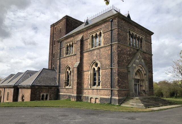
Haythorne's Plantation is a historic woodland located in Durham, England. Covering an area of approximately 100 acres, it is a significant site for conservation and recreation purposes. The woodland is part of a larger forested area in the region, contributing to the preservation of natural habitats and biodiversity.

The plantation is characterized by a diverse range of tree species, including oak, birch, beech, and Scots pine. This variety of trees creates a rich and vibrant ecosystem, offering a home for numerous species of birds, mammals, and insects. The woodland is known for its tranquil ambiance, providing visitors with a peaceful retreat from the hustle and bustle of urban life.

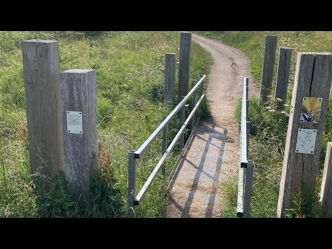
Haythorne's Plantation offers a network of well-maintained walking trails, allowing visitors to explore the woodland and enjoy its natural beauty. These trails are suitable for all fitness levels and provide opportunities for leisurely strolls, jogging, or even bird-watching. The paths are clearly signposted, ensuring visitors can navigate the woodland easily.

The plantation has a long history, dating back several centuries. It was once part of a larger estate and played a significant role in the local economy, providing timber for construction and fuel. Today, it stands as a testament to the region's rich history and the importance of woodland conservation.

Haythorne's Plantation is a beloved retreat for locals and tourists alike, offering a peaceful and picturesque environment for recreational activities and nature appreciation. Its accessibility, diverse ecosystem, and historical significance make it a must-visit destination for nature enthusiasts and history buffs in Durham.

If you have any feedback on the listing, please let us know in the comments section below.

Haythorne's Plantation Images

Images are sourced within 2km of 54.806702/-1.336311 or Grid Reference NZ4245. Thanks to Geograph Open Source API. All images are credited.

Hawthorn Dene Bare trees and a carpet of wild garlic on the northern edge of Hawthorn Dene in spring.
Hawthorn Dene
Bare trees and a carpet of wild garlic on the northern edge of Hawthorn Dene in spring.
Hawthorn Burn The burn seen deep in Hawthorn Dene.
Hawthorn Burn
The burn seen deep in Hawthorn Dene.
Hawthorn Dene Viaduct The viaduct carries the Durham Coast railway across Hawthorn Dene. Built in 1905 the viaduct is grade II listed. The railway was once very busy with freight traffic, allowing connection to Tyne Dock, Sunderland docks, Seaham harbour, Hartlepool docks, the Durham coalfield's coastal collieries, and Billingham with the associated petrochemical industries on the North side of the Tees. The line still sees a smattering of freight traffic but is primarily the passenger route linking Newcastle to Middlesbrough via Sunderland, Hartlepool and Stockton, with an hourly service.
Hawthorn Dene Viaduct
The viaduct carries the Durham Coast railway across Hawthorn Dene. Built in 1905 the viaduct is grade II listed. The railway was once very busy with freight traffic, allowing connection to Tyne Dock, Sunderland docks, Seaham harbour, Hartlepool docks, the Durham coalfield's coastal collieries, and Billingham with the associated petrochemical industries on the North side of the Tees. The line still sees a smattering of freight traffic but is primarily the passenger route linking Newcastle to Middlesbrough via Sunderland, Hartlepool and Stockton, with an hourly service.
Hawthorn Burn exiting Hawthorn Dene Several denes run west - east into the North Sea along the Durham coast. They were formed by meltwaters cutting channels through the limestone ridge that runs down the Durham coast.
Hawthorn Burn exiting Hawthorn Dene
Several denes run west - east into the North Sea along the Durham coast. They were formed by meltwaters cutting channels through the limestone ridge that runs down the Durham coast.
Beach Art, Hawthorn Hive
Blast Beach The name of the beach reflects the use of the location for early furnaces using the local coal, limestone and iron ore. This was overtaken by the growth of the coal industry and the iron & steel industry migrated and grew into the large works associated with the Derwent valley (Consett) and Teesside, both areas with iron ore deposits. The industrial units seen on the headland at the top of the image are on the site of Dawdon colliery, which until the early 1990s tipped its spoil straight onto the beach to be taken on the tide. The Durham coastline has been significantly cleaned up since the end of deep mining, though the demarcation between clean beach and a remaining layer of waste can be seen at the high tide line running down the long axis of the beach.
Blast Beach
The name of the beach reflects the use of the location for early furnaces using the local coal, limestone and iron ore. This was overtaken by the growth of the coal industry and the iron & steel industry migrated and grew into the large works associated with the Derwent valley (Consett) and Teesside, both areas with iron ore deposits. The industrial units seen on the headland at the top of the image are on the site of Dawdon colliery, which until the early 1990s tipped its spoil straight onto the beach to be taken on the tide. The Durham coastline has been significantly cleaned up since the end of deep mining, though the demarcation between clean beach and a remaining layer of waste can be seen at the high tide line running down the long axis of the beach.
Dalton Pumping Station Grade II listed pumping station from the 1870s, designed by Thomas Hawksley. The pumping station was taken out of use in the 1940s, and the upper portion of the central tower was removed in the 1960s. After several abortive attempts to re-purpose the building, as of August 2021 it is in the process of being renovated as a wedding venue.
Dalton Pumping Station
Grade II listed pumping station from the 1870s, designed by Thomas Hawksley. The pumping station was taken out of use in the 1940s, and the upper portion of the central tower was removed in the 1960s. After several abortive attempts to re-purpose the building, as of August 2021 it is in the process of being renovated as a wedding venue.
Easington Miners' Picnic
The Pit Cage Monument, Easington Colliery Standing on the Durham Heritage Coast in the Spring sunshine the monument is a memorial to the colliery which closed in 1993.
See Andrew Curtis's photo for more information <a href="https://www.geograph.org.uk/photo/1578726">NZ4344 : Pit Cage Monument, Easington Colliery</a>
The Pit Cage Monument, Easington Colliery
Standing on the Durham Heritage Coast in the Spring sunshine the monument is a memorial to the colliery which closed in 1993. See Andrew Curtis's photo for more information NZ4344 : Pit Cage Monument, Easington Colliery
Hawthorn Village
Hawthorn Village
Easington Services Although signed as 'services', on A roads the facilities often amount to little more than a fuel station and this is the case here at Easington on the A19. The southbound services have a surprising amount of car and HGV parking, however, although in this view it was hardly being used. The forecourt and building are behind the photographer.
Easington Services
Although signed as 'services', on A roads the facilities often amount to little more than a fuel station and this is the case here at Easington on the A19. The southbound services have a surprising amount of car and HGV parking, however, although in this view it was hardly being used. The forecourt and building are behind the photographer.
Pedestrian level crossing on the Durham Coast railway line
The Cage, Easington Colliery Three tiered pit cage monument commemorating Easington Colliery.
The Cage, Easington Colliery
Three tiered pit cage monument commemorating Easington Colliery.
Durham Coast railway Looking north from adjacent to the former site of Easington Colliery.
Durham Coast railway
Looking north from adjacent to the former site of Easington Colliery.
East Coast Main Line heading north The view is from a footpath crossing of the railway route where public access is made simply by opening a gate and walking ahead. There's a set of warning notices and an obvious green / red light signal that give instruction and clearance on making the move, as shown in David Robinson's image - <a title="https://www.geograph.org.uk/photo/7425968" href="https://www.geograph.org.uk/photo/7425968">Link</a> .
East Coast Main Line heading north
The view is from a footpath crossing of the railway route where public access is made simply by opening a gate and walking ahead. There's a set of warning notices and an obvious green / red light signal that give instruction and clearance on making the move, as shown in David Robinson's image - Link .
Walking party at field edge The walking group, (slightly misplaced), is seeking a continuing path through woodland known as New Plantation.
(The individual with the pushchair was not part of the group.)
Walking party at field edge
The walking group, (slightly misplaced), is seeking a continuing path through woodland known as New Plantation. (The individual with the pushchair was not part of the group.)
Houses, walkers and cattle at Dene View The houses are at Dene View at the eastern side of the village of Hawthorn.
The cattle belong presumably at South Farm which is behind the camera position.
The walking party has recently passed through the field with the animals using the sign-posted public footpath.
Houses, walkers and cattle at Dene View
The houses are at Dene View at the eastern side of the village of Hawthorn. The cattle belong presumably at South Farm which is behind the camera position. The walking party has recently passed through the field with the animals using the sign-posted public footpath.
Wheat field with path and walkers The field with ripening wheat has a public footpath passing through and quite properly that path has been either left un-sown or reinstated as is required. Hawthorn is the village in the distance.
Wheat field with path and walkers
The field with ripening wheat has a public footpath passing through and quite properly that path has been either left un-sown or reinstated as is required. Hawthorn is the village in the distance.
Show me another place!

Haythorne's Plantation is located at Grid Ref: NZ4245 (Lat: 54.806702, Lng: -1.336311)

Unitary Authority: County Durham

Police Authority: Durham

What 3 Words

///aimed.carting.nursery. Near Hawthorn, Co. Durham

Related Wikis

Hawthorn Dene

Hawthorn Dene is a Site of Special Scientific Interest in the Easington district of County Durham, England. The site occupies the incised valley of Hawthorn...

Hawthorn Quarry

Hawthorn Quarry is a Site of Special Scientific Interest in the Easington district of east County Durham, England. It is a working quarry, currently operated...

Hawthorn, County Durham

Hawthorn is a village in County Durham, England. It is situated between Seaham and Easington. The only public building in the village of Hawthorn is the...

Stony Cut, Cold Hesledon

Stony Cut, Cold Hesledon is a Site of Special Scientific Interest in the Easington district of north-east County Durham, England. It consists of a shallow...

Related Videos

Seaham Coastal Walk, (4K)

The Durham Coastal Footpath is an 11 mile walking route from Seaham to Crimdon following the England Coast Path National ...

bit of a windy one roundabout stealthcamp [Easington village County Durham] stealthcampinguk

back out again for a stealthcamp on a roundabout using the Alpkit Elan hooped bivvy bag cooking burgers and drinking beers ...

Sea glass search on Blast Beach in Seaham, Durham.

Join us on an exciting adventure to Seaham, a charming coastal town in Durham, North of England, as we hunt for Seaham's ...

~ Walking in Billy Elliot Country ~ Hobnail Boots and Ballet Shoes ~ Part 4 ~

Walking in Billy Elliot Country ~ Hobnail Boots and Ballet Shoes ~ A Video Journal ~ Part 4. Written and Presented by Matt Wells.

Nearby Amenities

Located within 500m of 54.806702,-1.336311
Power: pole
Lat/Long: 54.8034074/-1.3405198
Power: pole
Lat/Long: 54.804056/-1.3408899
Power: pole
Lat/Long: 54.8048289/-1.3419132
Power: pole
Switch: mechanical
Lat/Long: 54.806112/-1.3436593
Power: pole
Transformer: distribution
Lat/Long: 54.8061066/-1.3437049
Hawthorn Dene
Board Type: nature
Fixme: Confirm exact location
Information: board
Operator: Durham Wildlife Trust
Tourism: information
Lat/Long: 54.8056259/-1.3366856
Hawthorn Dene Nature Reserve
Information: map
Operator: Durham Wildlife Trust
Tourism: information
Lat/Long: 54.8055474/-1.3368646
Power: pole
Lat/Long: 54.8040676/-1.3408068
Power: pole
Lat/Long: 54.8042933/-1.3399056
Power: pole
Lat/Long: 54.8045236/-1.3389802
Power: pole
Lat/Long: 54.8042113/-1.3381836
Power: pole
Lat/Long: 54.8038944/-1.3373548
The data included in this document is from www.openstreetmap.org. The data is made available under ODbL.

Have you been to Haythorne's Plantation?

Leave your review of Haythorne's Plantation below (or comments, questions and feedback).