Bury Copse

Wood, Forest in Hampshire New Forest

England

Bury Copse

Containers beside Eling Creek The wharf is no longer active - this container store is serviced by road.
Containers beside Eling Creek Credit: David Martin

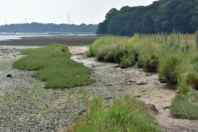
Bury Copse is a picturesque woodland located in the county of Hampshire, England. Situated near the village of Bighton, this forested area covers approximately 20 hectares of land. Bury Copse is known for its diverse range of flora and fauna, making it a popular destination for nature enthusiasts and walkers.

The woodland is predominantly composed of deciduous trees, such as oak, ash, and beech, which create a dense and lush canopy. The forest floor is covered in a rich carpet of ferns, mosses, and wildflowers, adding to the area's natural beauty.

Bury Copse is home to a variety of wildlife, including small mammals like squirrels, rabbits, and hedgehogs. The woodland is also a haven for bird species, with frequent sightings of woodpeckers, owls, and songbirds. In the spring and summer months, the air is filled with the melodious sounds of birdsong.

The forest offers several walking trails, allowing visitors to explore its peaceful and tranquil environment. These trails meander through the woodland, offering glimpses of small streams, fallen logs, and occasional clearings where sunlight filters through the canopy.

Bury Copse is popular among nature photographers, who are drawn to its enchanting and photogenic landscapes. The changing seasons bring a kaleidoscope of colors to the woodland, with vibrant autumn foliage and blooming wildflowers in the spring.

Overall, Bury Copse is a captivating woodland that offers a serene escape from the hustle and bustle of everyday life. Its natural beauty and abundant wildlife make it a must-visit destination for those seeking a peaceful retreat in the heart of Hampshire.

If you have any feedback on the listing, please let us know in the comments section below.

Bury Copse Images

Images are sourced within 2km of 50.902873/-1.4649778 or Grid Reference SU3711. Thanks to Geograph Open Source API. All images are credited.

Containers beside Eling Creek The wharf is no longer active - this container store is serviced by road.
Containers beside Eling Creek
The wharf is no longer active - this container store is serviced by road.
Waterside apartments overlooking Eling tide mill The ground floor of this block contains a visitor centre and cafe.
Waterside apartments overlooking Eling tide mill
The ground floor of this block contains a visitor centre and cafe.
View across Eling Creek to the Anchor Inn
On the shore beside Eling Channel
Southampton : Third Avenue Looking along Third Avenue off Millbrook Road West.
Southampton : Third Avenue
Looking along Third Avenue off Millbrook Road West.
Southampton : Co-op Food - Petrol Millbrook A petrol station and shop alongside Millbrook Road West.
Southampton : Co-op Food - Petrol Millbrook
A petrol station and shop alongside Millbrook Road West.
Southampton : Millbrook Road West A33 Heading along Millbrook Road West.
Southampton : Millbrook Road West A33
Heading along Millbrook Road West.
Southampton : Lok 'n Store Self Storage A self storage business seen from Millbrook Road West.
Southampton : Lok 'n Store Self Storage
A self storage business seen from Millbrook Road West.
Southampton : Millbrook Flyover A33 Looking along the A33.
Southampton : Millbrook Flyover A33
Looking along the A33.
Southampton : Redbridge Road A33 Looking along Redbridge Road.
Southampton : Redbridge Road A33
Looking along Redbridge Road.
Southampton : Redbridge Flyover A33 Looking along the A33.
Southampton : Redbridge Flyover A33
Looking along the A33.
Eling toll bridge and toll-keeper's booth With Eling Tide Mill on the left.
Eling toll bridge and toll-keeper's booth
With Eling Tide Mill on the left.
Premises of Eling Sailing Club Adjoining Eling Tide Mill. There was once a balcony on the front of the sailing club and I have photographs of family members standing on it during a wedding reception in the 1960s, but it was removed some years ago, presumably on safety grounds. Viewed from Downs Park Crescent.
Premises of Eling Sailing Club
Adjoining Eling Tide Mill. There was once a balcony on the front of the sailing club and I have photographs of family members standing on it during a wedding reception in the 1960s, but it was removed some years ago, presumably on safety grounds. Viewed from Downs Park Crescent.
Eling Toll Bridge tariff Compare with <a href="https://www.geograph.org.uk/photo/210464">SU3612 : Eling Toll Bridge Fees  in 2002</a>.
Eling Toll Bridge tariff
Eling Mill The building was probably associated with Eling Tide Mill, which stands just across Eling Lane. It is now mostly converted to apartments, but also houses the Eling Heritage Centre on the ground floor. After WWII, Allis Chalmers, a US agricultural equipment company, used the building for tractor assembly and as a lad, I recall seeing convoys of tractors leaving the building for onward transportation, possibly from Eling Wharf. I believe that tractor assembly here ceased in the early 1960s
Eling Mill
The building was probably associated with Eling Tide Mill, which stands just across Eling Lane. It is now mostly converted to apartments, but also houses the Eling Heritage Centre on the ground floor. After WWII, Allis Chalmers, a US agricultural equipment company, used the building for tractor assembly and as a lad, I recall seeing convoys of tractors leaving the building for onward transportation, possibly from Eling Wharf. I believe that tractor assembly here ceased in the early 1960s
A small egret in Eling Creek Just upstream from the tide mill.
A small egret in Eling Creek
Just upstream from the tide mill.
Eling Wharf Once used by 'coasters' - small cargo vessels which could navigate the shallows of inland waters. They have almost died out, and the wharf is now mostly used for container storage. Across the River Test lies the Prince Charles Container Port.
Eling Wharf
Once used by 'coasters' - small cargo vessels which could navigate the shallows of inland waters. They have almost died out, and the wharf is now mostly used for container storage. Across the River Test lies the Prince Charles Container Port.
High and dry Vessels In Eling Creek at low tide.
High and dry
Vessels In Eling Creek at low tide.
Show me another place!

Bury Copse is located at Grid Ref: SU3711 (Lat: 50.902873, Lng: -1.4649778)

Administrative County: Hampshire

District: New Forest

Police Authority: Hampshire

What 3 Words

///rises.corn.motion. Near Marchwood, Hampshire

Nearby Locations

Sparrow's Copse Bury Copse

Related Wikis

Eling and Bury Marshes

Eling and Bury Marshes is a 112.3-hectare (277-acre) biological Site of Special Scientific Interest between Totton and Southampton in Hampshire. It is...

Bartley Water

Bartley Water is a two-branch small river in the New Forest district of Hampshire, England. It drains the north and north-east of the New Forest National...

Eling Tide Mill

Eling Tide Mill, situated on an artificial causeway in Eling in Hampshire, England, is one of only two remaining operating tide mills in the United Kingdom...

Staplewood Campus

Staplewood Campus in Marchwood, Hampshire is the training ground of Southampton Football Club. It was the home ground of Road-Sea Southampton until 1987...

Marchwood

Marchwood is a village and civil parish located in Hampshire, England. It lies between Totton and Hythe on the western shore of Southampton Water and directly...

Southampton F.C. Under-21s and Academy

Southampton F.C. Under-21s and Academy or Saints U21s and Academy is the youth organisation run by Southampton F.C. to encourage and develop young footballers...

SS Shieldhall

SS Shieldhall is a preserved steamship that operates from Southampton. She is one of the last reciprocating steam engined ships built, using technology...

Marchwood railway station

Marchwood railway station was an intermediate station on the Totton, Hythe and Fawley Light Railway, which was built along the coast of Southampton Water...

Nearby Amenities

Located within 500m of 50.902873,-1.4649778
Source: PGS
Lat/Long: 50.9038542/-1.4654418
Source: PGS
Lat/Long: 50.9046787/-1.4663048
Power: tower
Lat/Long: 50.9044085/-1.4670561
Power: tower
Lat/Long: 50.9029677/-1.4642336
Power: tower
Lat/Long: 50.9012798/-1.4605099
Bus Stop
Bury Farm
Bus: yes
Naptan AtcoCode: 1900HA080246
Naptan Bearing: NW
Naptan CommonName: Bury Farm
Naptan Crossing: Bury Road
Naptan NaptanCode: hamapwma
Naptan Street: Marchwood Road
Naptan Verified: no
Source: naptan_import
Lat/Long: 50.9010413/-1.4653053
Bus Stop
Bury Farm
Bus: yes
Naptan AtcoCode: 1900HA080247
Naptan Bearing: SE
Naptan CommonName: Bury Farm
Naptan Crossing: Bury Road
Naptan NaptanCode: hamapwmd
Naptan Street: Marchwood Road
Naptan Verified: no
Source: naptan_import
Lat/Long: 50.900887/-1.4649942
Seamark Buoy Lateral Category: port
Seamark Buoy Lateral Colour: red
Seamark Buoy Lateral Shape: can
Seamark Buoy Lateral System: iala-a
Seamark Light Character: Oc
Seamark Light Colour: red
Seamark Light Group: 2
Seamark Light Period: 4
Seamark Name: SG 14
Seamark Type: buoy_lateral
Lat/Long: 50.9045608/-1.4644976
Seamark Buoy Lateral Category: port
Seamark Buoy Lateral Colour: red
Seamark Buoy Lateral Shape: can
Seamark Light Character: Fl
Seamark Light Colour: red
Seamark Light Group: 3
Seamark Light Period: 5
Seamark Name: SG 16
Seamark Type: buoy_lateral
Lat/Long: 50.9069947/-1.4649746
Seamark Buoy Lateral Category: port
Seamark Buoy Lateral Colour: red
Seamark Buoy Lateral Shape: can
Seamark Light Character: Fl
Seamark Light Colour: red
Seamark Light Group: 2
Seamark Light Period: 5
Seamark Name: SG 12
Seamark Topmark Colour: red
Seamark Topmark Shape: cylinder
Seamark Type: buoy_lateral
Lat/Long: 50.9047871/-1.4597416
Bury Swinging Ground
Depth: 12.6 m
Place: locality
Lat/Long: 50.9063952/-1.4617788
Crossing
Bicycle: yes
Crossing: unmarked
Crossing Island: yes
Crossing Markings: no
Kerb: flush
Tactile Paving: yes
Lat/Long: 50.9040363/-1.4713466
Power: tower
Lat/Long: 50.9042163/-1.4699765
Crossing
Lat/Long: 50.9006984/-1.4648659
The data included in this document is from www.openstreetmap.org. The data is made available under ODbL.

Have you been to Bury Copse?

Leave your review of Bury Copse below (or comments, questions and feedback).