Arthrath

Settlement in Aberdeenshire

Scotland

Arthrath

Roof Damage at Overton A once grand steading in deterioration at Overton of Birness.
Roof Damage at Overton Credit: Andrew Wood

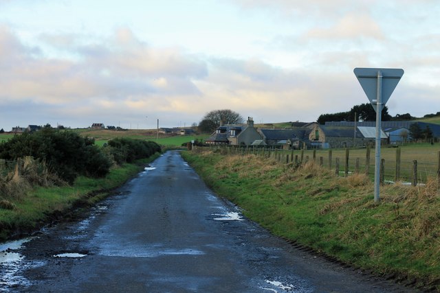
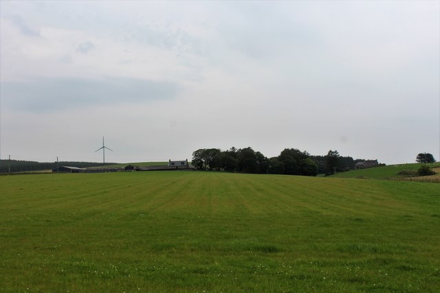
Arthrath is a small village located in Aberdeenshire, Scotland. Situated in the northeast of the country, approximately 30 miles north of Aberdeen, it is part of the rural landscape of the region. Arthrath is surrounded by rolling hills and lush green pastures, offering a picturesque setting for residents and visitors alike.

The village is known for its tranquil atmosphere and close-knit community. With a population of around 200 people, Arthrath exudes a welcoming and friendly ambiance. The residents take pride in their village, maintaining its charm and character.

Arthrath features a few local amenities, including a village hall that serves as a central hub for social gatherings and events. The hall hosts various community activities, such as meetings, dances, and craft fairs, fostering a sense of togetherness among the villagers.

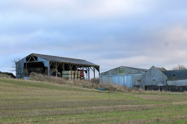
The village’s economy primarily relies on agriculture, with many residents involved in farming or related industries. The fertile land surrounding Arthrath allows for the cultivation of crops and the rearing of livestock, contributing to the local economy.

While Arthrath may be small in size, its proximity to larger towns and cities provides residents with access to a wider range of amenities and services. The nearby city of Aberdeen offers shopping centers, schools, and healthcare facilities, ensuring that the needs of Arthrath's residents are met.

Overall, Arthrath is a tranquil and close-knit village, nestled in the scenic countryside of Aberdeenshire. Its community spirit, agricultural heritage, and picturesque surroundings make it an appealing place to live or visit for those seeking a peaceful and rural lifestyle.

If you have any feedback on the listing, please let us know in the comments section below.

Arthrath Images

Images are sourced within 2km of 57.417237/-2.060396 or Grid Reference NJ9636. Thanks to Geograph Open Source API. All images are credited.

Roof Damage at Overton A once grand steading in deterioration at Overton of Birness.
Roof Damage at Overton
A once grand steading in deterioration at Overton of Birness.
Overton Barns The Dutch barn and buildings at Overton farm.
Overton Barns
The Dutch barn and buildings at Overton farm.
Slow for Berefold Traffic signs at the entrance to the hamlet of Berefold.
Slow for Berefold
Traffic signs at the entrance to the hamlet of Berefold.
Kamiri by Berefold A smallholding by Berefold with a new shed evident.
Kamiri by Berefold
A smallholding by Berefold with a new shed evident.
Road to Ardarg The road, albeit potholed, to Ardarg Farm and beyond.
Road to Ardarg
The road, albeit potholed, to Ardarg Farm and beyond.
Wellhead by Dudwick The smallholding of Wellhead by Dudwick plantation.
Wellhead by Dudwick
The smallholding of Wellhead by Dudwick plantation.
Dudwick Sheep Sheep grazing by Dudwick.
Dudwick Sheep
Sheep grazing by Dudwick.
Where There's Muck Usually money, but by Dudwick its sheep, hopefully it will amount to the same thing!
Where There's Muck
Usually money, but by Dudwick its sheep, hopefully it will amount to the same thing!
Blowing in the Wind Wires blowing in what was a strong breeze by the Mains of Dudwick.
Blowing in the Wind
Wires blowing in what was a strong breeze by the Mains of Dudwick.
Arthrath Road The minor road from Mains of Dudwick to Arthrath.
Arthrath Road
The minor road from Mains of Dudwick to Arthrath.
Little Mains The converted farm of little Mains of Dudwick.
Little Mains
The converted farm of little Mains of Dudwick.
Ruin by Dudwick An old ruined croft by woodland on the Hill of Dudwick.
Ruin by Dudwick
An old ruined croft by woodland on the Hill of Dudwick.
Arthrath Ruins North Arthtrath or what remains of this old small farm.
Arthrath Ruins
North Arthtrath or what remains of this old small farm.
Hill of Dudwick Ruins An extensive range of farm ruins and "golfball" on the Hill of Dudwick.
Hill of Dudwick Ruins
An extensive range of farm ruins and "golfball" on the Hill of Dudwick.
Laverockley Ruin Laverockley, translating as pasture of the lark, this ruin has reverted to nature the old ruins decaying.
Laverockley Ruin
Laverockley, translating as pasture of the lark, this ruin has reverted to nature the old ruins decaying.
Grass at Milltown of Birness A large grass field by Milltown of Birness.
Grass at Milltown of Birness
A large grass field by Milltown of Birness.
Ardarg Farm The roadside farm of Ardarg.
Ardarg Farm
The roadside farm of Ardarg.
East Ardarg East Ardarg farm as seen from Ardarg.
East Ardarg
East Ardarg farm as seen from Ardarg.
Show me another place!

Arthrath is located at Grid Ref: NJ9636 (Lat: 57.417237, Lng: -2.060396)

Unitary Authority: Aberdeenshire

Police Authority: North East

What 3 Words

///supported.teacher.acids. Near Ellon, Aberdeenshire

Nearby Locations

Arthrath

Related Wikis

Kinmuck Castle

Kinmuck Castle was a 14th-century castle, about 4.0 miles (6.4 km) north-east of Ellon, Aberdeenshire, Scotland, at, or close to, Mains of Kinmuck. Alternative...

Arnage Castle

Arnage Castle is a country house, incorporating a Z-plan tower house, located around 4 miles (6.4 km) north of Ellon, in Aberdeenshire, north-east Scotland...

Arnage railway station

Arnage railway station was a railway station in Arnage, Aberdeenshire. == History == The station was opened on 18 July 1861 by the Formartine and Buchan...

Formartine and Buchan Way

The Formartine and Buchan Way is a long-distance trail in Scotland, extending from Dyce north to Peterhead and Fraserburgh in the Buchan and Formartine...

Nearby Amenities

Located within 500m of 57.417237,-2.060396
Power: pole
Lat/Long: 57.4185766/-2.0531122
Power: pole
Lat/Long: 57.418613/-2.0542961
Power: pole
Lat/Long: 57.418659/-2.0555138
Power: pole
Lat/Long: 57.4186772/-2.0566436
Power: pole
Lat/Long: 57.4187196/-2.057688
Power: pole
Lat/Long: 57.4187014/-2.0586693
Power: pole
Lat/Long: 57.4186699/-2.0598262
Power: pole
Lat/Long: 57.4186421/-2.0609831
Power: pole
Lat/Long: 57.4185996/-2.0621512
Power: pole
Lat/Long: 57.4181136/-2.0539945
Power: pole
Lat/Long: 57.4176373/-2.0548881
Power: pole
Lat/Long: 57.4171525/-2.0557929
Power: pole
Lat/Long: 57.4166785/-2.0566684
Power: pole
Lat/Long: 57.4162434/-2.0575439
Power: pole
Lat/Long: 57.4157889/-2.0584127
Power: pole
Lat/Long: 57.4153634/-2.0592725
Power: pole
Lat/Long: 57.4149477/-2.060076
Power: pole
Lat/Long: 57.4145355/-2.0608953
Power: pole
Lat/Long: 57.4140579/-2.0618203
Power: pole
Lat/Long: 57.4135585/-2.0618833
Power: pole
Lat/Long: 57.4129136/-2.0619621
Power: pole
Lat/Long: 57.4134373/-2.063119
Power: pole
Lat/Long: 57.4133331/-2.0642511
Power: pole
Lat/Long: 57.4181415/-2.0575034
Power: pole
Lat/Long: 57.4180482/-2.0590317
Power: pole
Lat/Long: 57.4174324/-2.0593693
Power: pole
Lat/Long: 57.4164216/-2.067948
Power: pole
Lat/Long: 57.4158992/-2.0678894
Power: pole
Lat/Long: 57.4152507/-2.0678242
The data included in this document is from www.openstreetmap.org. The data is made available under ODbL.

Have you been to Arthrath?

Leave your review of Arthrath below (or comments, questions and feedback).