Millstone Edge Rough

Wood, Forest in Yorkshire

England

Millstone Edge Rough

Sign in Coppice Wood
Sign in Coppice Wood Credit: Dave Pickersgill

Millstone Edge Rough is a scenic woodland area located in Yorkshire, England. Covering an expansive area, this forest is a haven for nature enthusiasts and outdoor adventurers alike. The woodland is characterized by its dense population of trees, mainly consisting of oak, beech, and birch. The towering trees provide a majestic canopy that offers shade during the summer months and a stunning display of colors in the autumn.

The forest floor is adorned with a variety of flora, including ferns, mosses, and wildflowers, creating a vibrant and diverse ecosystem. Millstone Edge Rough is also known for its abundant wildlife, with a wide range of species calling this woodland home. Visitors may spot birds such as woodpeckers, owls, and buzzards, as well as small mammals like rabbits, squirrels, and foxes.

The rough terrain of the area adds an element of adventure to exploring the forest. Millstone Edge, a prominent feature within the woodland, offers breathtaking views of the surrounding landscape, making it a popular spot for hikers and photographers. The area is also crisscrossed with a network of trails, allowing visitors to immerse themselves in the natural beauty of the forest.

In addition to its natural wonders, Millstone Edge Rough has historical significance. The name "Millstone" is derived from the presence of millstones used in the nearby mills during the industrial revolution. This historical link adds a layer of cultural richness to the area.

Overall, Millstone Edge Rough is a picturesque woodland that offers both tranquility and adventure. Its diverse ecosystem, stunning views, and rich history make it a must-visit destination for nature enthusiasts and history buffs alike.

If you have any feedback on the listing, please let us know in the comments section below.

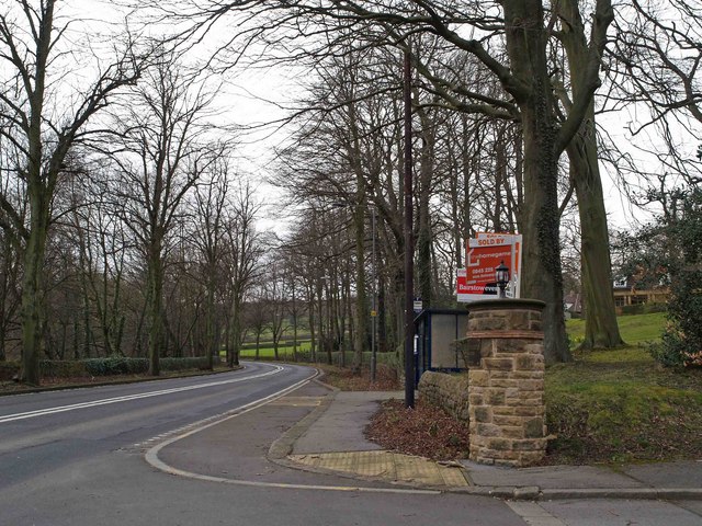
Millstone Edge Rough Images

Images are sourced within 2km of 53.385108/-1.5337545 or Grid Reference SK3187. Thanks to Geograph Open Source API. All images are credited.

Sign in Coppice Wood
Elliott's Rock by Black Brook Legend says that the early Victorian poet Ebenezer Elliott used to visit this spot and carved his surname on the stone shown here. You can still make out some of the letters. Of course the carving could have been done by one of Elliott's many acolytes. He wasn't the kind of man who paid much heed to self-aggrandisement.
Elliott's Rock by Black Brook
Legend says that the early Victorian poet Ebenezer Elliott used to visit this spot and carved his surname on the stone shown here. You can still make out some of the letters. Of course the carving could have been done by one of Elliott's many acolytes. He wasn't the kind of man who paid much heed to self-aggrandisement.
Elliott's Rock, Black Brook This carved rock is associated with the early Victorian poet, Ebenezer Elliott (1781-1849). It is said that he often visited this place for quiet contemplation. I understand that the words "ELLIOTT'S ROCK" were once clearly visible but decades have passed since then and now it's hard to make out the lettering.
Elliott's Rock, Black Brook
This carved rock is associated with the early Victorian poet, Ebenezer Elliott (1781-1849). It is said that he often visited this place for quiet contemplation. I understand that the words "ELLIOTT'S ROCK" were once clearly visible but decades have passed since then and now it's hard to make out the lettering.
Black Brook, flowing down from Lodge Moor Soon it will plunge down to The River Rivelin. It was in this tranquil spot that the early Victorian poet, Ebenezer Elliott, often came for quiet contemplation.
Black Brook, flowing down from Lodge Moor
Soon it will plunge down to The River Rivelin. It was in this tranquil spot that the early Victorian poet, Ebenezer Elliott, often came for quiet contemplation.
Old packhorse bridge over The River Rivelin Just east of Rails Road
Old packhorse bridge over The River Rivelin
Just east of Rails Road
Just like Louisiana Neglected mill pond in The Rivelin Valley
Just like Louisiana
Neglected mill pond in The Rivelin Valley
Rivelin Valley Country Park Old footbridge and weir in the Rivelin Valley Country Park.
Rivelin Valley Country Park
Old footbridge and weir in the Rivelin Valley Country Park.
Underbank Unitarian Chapel Chapel and cemetery at Underbank, founded in 1652, with the chapel consecrated in 1743. There is another building across the road which also resembles a chapel.
Underbank Unitarian Chapel
Chapel and cemetery at Underbank, founded in 1652, with the chapel consecrated in 1743. There is another building across the road which also resembles a chapel.
Rivelin Valley Upper Coppice Wheel
For sale Lots for sale at the entrance to the estate of apartments and houses formed in the buildings of Rivelin Valley Hospital. The estate is now gated to prevent access.
For sale
Lots for sale at the entrance to the estate of apartments and houses formed in the buildings of Rivelin Valley Hospital. The estate is now gated to prevent access.
Underbank Chapel
Underbank Chapel
Knowle Top from Underbank
Top of the Bank at Underbank The white 'flowers' in the foreground are Rose Bay Willow Herb 'gone to seed' ... they looked very impressive.
Top of the Bank at Underbank
The white 'flowers' in the foreground are Rose Bay Willow Herb 'gone to seed' ... they looked very impressive.
Underbank Chapel ... 2 years later The 'other Chapel' referred to in Image 132680 is Underbank Day and Sunday School which is linked to this image. <a href="https://www.geograph.org.uk/photo/132680">SK2988 : Underbank Unitarian Chapel</a> <a href="https://www.geograph.org.uk/photo/972447">SK2988 : Underbank Day and Sunday School</a>
Underbank Chapel ... 2 years later
The 'other Chapel' referred to in Image 132680 is Underbank Day and Sunday School which is linked to this image. SK2988 : Underbank Unitarian Chapel SK2988 : Underbank Day and Sunday School
Underbank Day and Sunday School Erected in 1855 and still looking in good condition.
Underbank Day and Sunday School
Erected in 1855 and still looking in good condition.
Path to the (former) King Edward VII Orthopaedic Hospital, Rivelin Valley, Sheffield This lovely hospital has now been sympathetically converted into Apartments and Townhouses.  This central pathway leads from the main gate up through the grounds to the (original) main entrance. <a href="https://www.geograph.org.uk/photo/1151252">SK2987 : The (former) King Edward VII Orthopaedic Hospital - 1, Rivelin Valley, Sheffield</a>
Path to the (former) King Edward VII Orthopaedic Hospital, Rivelin Valley, Sheffield
This lovely hospital has now been sympathetically converted into Apartments and Townhouses. This central pathway leads from the main gate up through the grounds to the (original) main entrance. SK2987 : The (former) King Edward VII Orthopaedic Hospital - 1, Rivelin Valley, Sheffield
The (former) King Edward VII Orthopaedic Hospital - 1, Rivelin Valley, Sheffield The main hospital entrance and administration block ... now nicely converted into apartments.  This central building has 'wings' - which were the actual wards - on either side.  The hospital was built as an isolation hospital for TB Patients who also suffered from Orthopaedic symptoms.  Update on 29.12.09 ... I have been kindly contacted by Peter Crouch who confirms that the hospital was designed by Arthur Kenyon, with the design and plans being featured in an architectural magazine in January 1929 ... thanks Peter. Update on 23.02.10 ... There are a number of pictures on the picturesheffield.com website which show the hospital as a working hospital. Follow this link ... <span class="nowrap"><a title="http://www.picturesheffield.com/" rel="nofollow ugc noopener" href="http://www.picturesheffield.com/">Link</a><img style="margin-left:2px;" alt="External link" title="External link - shift click to open in new window" src="https://s1.geograph.org.uk/img/external.png" width="10" height="10"/></span> ... then Select H and then Hospitals in the search facility ... then you have to scroll through them all. There are at least two blocks of pictures to view. <a href="https://www.geograph.org.uk/photo/724016">SK2987 : For sale</a> <a href="https://www.geograph.org.uk/photo/1151243">SK2987 : Path to the (former) King Edward VII Orthopaedic Hospital, Rivelin Valley, Sheffield</a> <a href="https://www.geograph.org.uk/photo/1151259">SK2987 : The (former) King Edward VII Orthopaedic Hospital - 2, Rivelin Valley, Sheffield</a> <a href="https://www.geograph.org.uk/photo/1151271">SK2987 : Ward at the (former) King Edward VII Orthopaedic Hospital, Rivelin Valley, Sheffield</a> <a href="https://www.geograph.org.uk/photo/1151276">SK2987 : Converted Buildings at the (former) King Edward VII Hospital - 1, Rivelin Valley, Sheffield</a> <a href="https://www.geograph.org.uk/photo/1151282">SK2987 : Converted Buildings at the (former) King Edward VII Hospital - 2, Rivelin Valley, Sheffield</a> <a href="https://www.geograph.org.uk/photo/1151287">SK2987 : Grounds of the (former) King Edward VII Orthopaedic Hospital, Rivelin Valley, Sheffield</a> <a href="https://www.geograph.org.uk/photo/1151300">SK2987 : Lodge House of the (former) King Edward VII Orthopaedic Hospital, Rivelin Valley, Sheffield</a>
The (former) King Edward VII Orthopaedic Hospital - 1, Rivelin Valley, Sheffield
The main hospital entrance and administration block ... now nicely converted into apartments. This central building has 'wings' - which were the actual wards - on either side. The hospital was built as an isolation hospital for TB Patients who also suffered from Orthopaedic symptoms. Update on 29.12.09 ... I have been kindly contacted by Peter Crouch who confirms that the hospital was designed by Arthur Kenyon, with the design and plans being featured in an architectural magazine in January 1929 ... thanks Peter. Update on 23.02.10 ... There are a number of pictures on the picturesheffield.com website which show the hospital as a working hospital. Follow this link ... LinkExternal link ... then Select H and then Hospitals in the search facility ... then you have to scroll through them all. There are at least two blocks of pictures to view. SK2987 : For sale SK2987 : Path to the (former) King Edward VII Orthopaedic Hospital, Rivelin Valley, Sheffield SK2987 : The (former) King Edward VII Orthopaedic Hospital - 2, Rivelin Valley, Sheffield SK2987 : Ward at the (former) King Edward VII Orthopaedic Hospital, Rivelin Valley, Sheffield SK2987 : Converted Buildings at the (former) King Edward VII Hospital - 1, Rivelin Valley, Sheffield SK2987 : Converted Buildings at the (former) King Edward VII Hospital - 2, Rivelin Valley, Sheffield SK2987 : Grounds of the (former) King Edward VII Orthopaedic Hospital, Rivelin Valley, Sheffield SK2987 : Lodge House of the (former) King Edward VII Orthopaedic Hospital, Rivelin Valley, Sheffield
The (former) King Edward VII Orthopaedic Hospital - 2, Rivelin Valley, Sheffield This view shows the wards situated either side of the main block ... presumably one side would be for male patients and the other for female patients. The wards had French Windows which could be opened to allow the beds to be pushed out into the sunshine. <a href="https://www.geograph.org.uk/photo/1151252">SK2987 : The (former) King Edward VII Orthopaedic Hospital - 1, Rivelin Valley, Sheffield</a>  Update on 23.02.10 ... follow this link ... <span class="nowrap"><a title="http://www.picturesheffield.com/" rel="nofollow ugc noopener" href="http://www.picturesheffield.com/">Link</a><img style="margin-left:2px;" alt="External link" title="External link - shift click to open in new window" src="https://s1.geograph.org.uk/img/external.png" width="10" height="10"/></span> ... and the search facility under H, then Hospitals, and you can see views of the hospital when it was a working facility.
The (former) King Edward VII Orthopaedic Hospital - 2, Rivelin Valley, Sheffield
This view shows the wards situated either side of the main block ... presumably one side would be for male patients and the other for female patients. The wards had French Windows which could be opened to allow the beds to be pushed out into the sunshine. SK2987 : The (former) King Edward VII Orthopaedic Hospital - 1, Rivelin Valley, Sheffield Update on 23.02.10 ... follow this link ... LinkExternal link ... and the search facility under H, then Hospitals, and you can see views of the hospital when it was a working facility.
Show me another place!

Millstone Edge Rough is located at Grid Ref: SK3187 (Lat: 53.385108, Lng: -1.5337545)

Division: West Riding

Unitary Authority: Sheffield

Police Authority: South Yorkshire

What 3 Words

///putty.once.shuts. Near Sheffield, South Yorkshire

Related Wikis

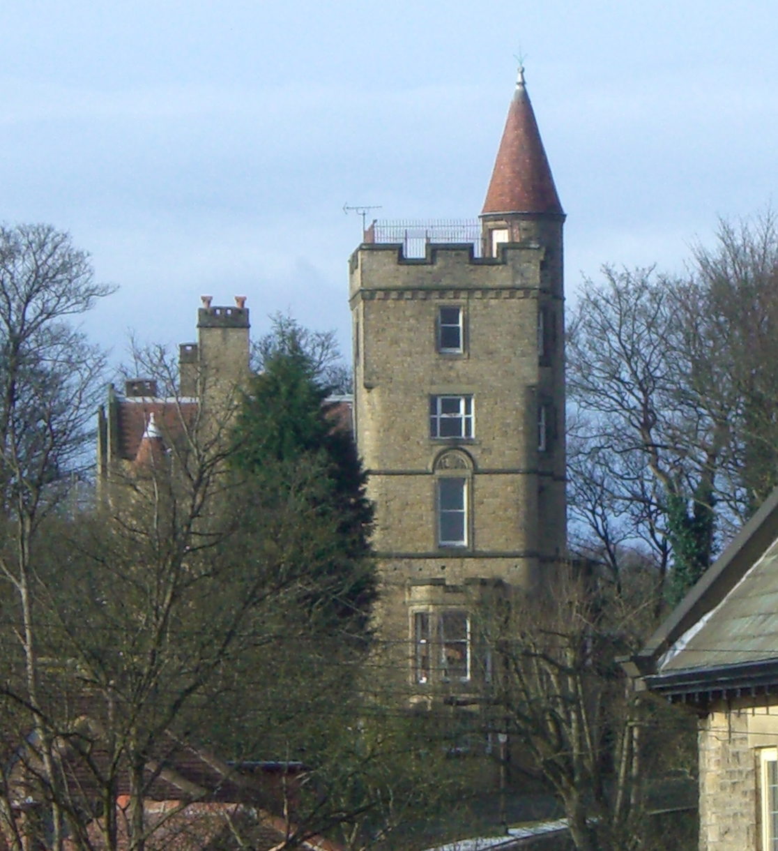
The Towers, Sheffield

The Towers is a small English country house situated in Sheffield, England. The house stands on Sandygate Road close to the junction with Coldwell Lane...

Crosspool

Crosspool is a suburb of the City of Sheffield, South Yorkshire, England, located 2.5 miles (4 km) west of the city centre. The suburb falls within the...

Hallam F.C.

Hallam Football Club is an English football club based in Crosspool, Sheffield, South Yorkshire. Founded in 1860, Hallam is the second oldest association...
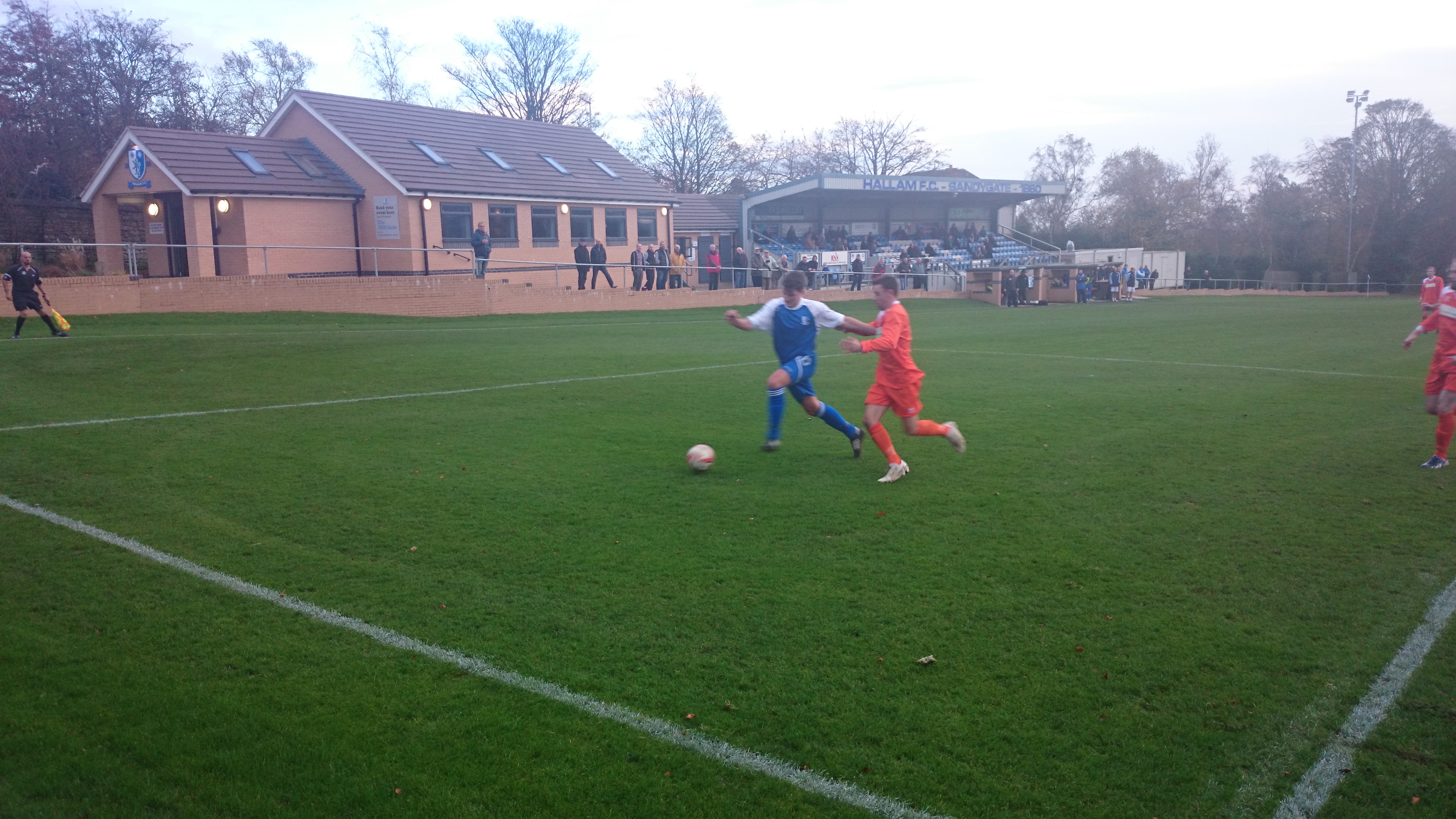
Sandygate (stadium)

Sandygate is a football and cricket stadium in the Sheffield suburb of Crosspool, South Yorkshire, England. It is home to Hallam F.C. and Hallam C.C....

Nearby Amenities

Located within 500m of 53.385108,-1.5337545
Turning Circle
Lat/Long: 53.3895485/-1.5341825
Bus Stop
Rivelin Valley Road/Tofts Lane
Alt Name: Rivelin Valley Road/Tofts Lane
Bus: yes
Naptan AltCommonName: Rivelin Valley Road/Tofts Lane
Naptan AtcoCode: 370020708
Naptan Bearing: W
Naptan CommonName: Rivelin Valley Road/Tofts Lane
Naptan Indicator: 20708
Naptan Landmark: OPPOSITE MODEL FARM
Naptan PlusbusZoneRef: ROTHCEN
Naptan Street: Rivelin Valley Road
Naptan Verified: no
Public Transport: platform
Source: naptan_import
Lat/Long: 53.3845797/-1.5390183
Bus Stop
Rivelin Valley Road/Tofts Lane
Alt Name: Rivelin Valley Road/Tofts Lane
Bus: yes
Naptan AltCommonName: Rivelin Valley Road/Tofts Lane
Naptan AtcoCode: 370020709
Naptan Bearing: E
Naptan CommonName: Rivelin Valley Road/Tofts Lane
Naptan Indicator: 20709
Naptan Landmark: 20709
Naptan PlusbusZoneRef: ROTHCEN
Naptan Street: Rivelin Valley Road
Naptan Verified: no
Public Transport: platform
Source: naptan_import
Lat/Long: 53.384707/-1.5393928
Bus Stop
Rivelin Valley Road/Long Lane
Bus: yes
Naptan AtcoCode: 370020735
Naptan Bearing: NE
Naptan CommonName: Rivelin Valley Road/Long Lane
Naptan Indicator: 20735
Naptan Landmark: RIVELIN GLEN COTTAGES
Naptan PlusbusZoneRef: ROTHCEN
Naptan Street: Rivelin Valley Road
Naptan Verified: no
Public Transport: platform
Source: naptan_import
Lat/Long: 53.3860911/-1.5347019
Bus Stop
Rivelin Valley Road/Long Lane
Bus: yes
Naptan AtcoCode: 370020736
Naptan Bearing: SW
Naptan CommonName: Rivelin Valley Road/Long Lane
Naptan Indicator: 20736
Naptan Landmark: RIVELIN GLEN QUARRY/OPP. RIVEL
Naptan PlusbusZoneRef: ROTHCEN
Naptan Street: Rivelin Valley Road
Naptan Verified: no
Public Transport: platform
Source: naptan_import
Lat/Long: 53.3862228/-1.5338885
Bus Stop
Liberty Drive/Liberty Hill
Bus: yes
Naptan AtcoCode: 370021877
Naptan Bearing: E
Naptan CommonName: Liberty Hill
Naptan Indicator: 21877
Naptan Landmark: opp House no. 9 to 35
Naptan NaptanCode: 37021877
Naptan PlusbusZoneRef: SHEFFLD
Naptan Street: Liberty Drive
Naptan Verified: no
Public Transport: platform
Shelter: yes
Source: naptan_import
Lat/Long: 53.3893279/-1.5321666
Bus Stop
Liberty Drive/Liberty Hill
Bus: yes
Naptan AtcoCode: 370021878
Naptan Bearing: W
Naptan CommonName: Liberty Hill
Naptan Indicator: 21878
Naptan Landmark: Opposite Car Park
Naptan NaptanCode: 37021878
Naptan PlusbusZoneRef: SHEFFLD
Naptan Street: Liberty Drive
Naptan Verified: no
Public Transport: platform
Source: naptan_import
Lat/Long: 53.3891508/-1.5329827
Waterway: weir
Lat/Long: 53.3873804/-1.5304298
Bench
Lat/Long: 53.38811/-1.5323433
Liberty Drive/Long Lane
Bus: yes
Public Transport: stop_position
Lat/Long: 53.3895637/-1.5344611
Grit Bin
Operator: Sheffield City Council
Operator Type: government
Operator Wikidata: Q7492609
Seasonal: no
Lat/Long: 53.3854185/-1.5393798
Barrier: stile
Lat/Long: 53.3836068/-1.5306213
Barrier: stile
Lat/Long: 53.3860717/-1.5300925
Barrier: stile
Lat/Long: 53.3867791/-1.5270458
Waterway: weir
Lat/Long: 53.3878515/-1.5288346
Waterway: weir
Lat/Long: 53.3848509/-1.5359837
Ford: yes
Lat/Long: 53.3844153/-1.5366817
Bridleway
Bicycle: yes
Designation: public_bridleway
Foot: yes
Horse: yes
Note: The western part of this is in fact a public footpath but signposted as a “permissive bridleway”. I have tagged it as a public bridleway so that it will be rendered correctly on the map.
Lat/Long: 53.3845737/-1.5385676
Parking
Lat/Long: 53.3885117/-1.5313727
Parking
Lat/Long: 53.3844419/-1.5335099
Barrier: stile
Lat/Long: 53.3863762/-1.5300585
Barrier: stile
Lat/Long: 53.3860635/-1.5286823
Barrier: stile
Lat/Long: 53.3864945/-1.5268368
Parking
Lat/Long: 53.3851292/-1.5293001
Barrier: stile
Lat/Long: 53.3873998/-1.5281137
Parking
Lat/Long: 53.3850715/-1.5287562
Barrier: stile
Lat/Long: 53.3844459/-1.5315841
Barrier: stile
Lat/Long: 53.3833132/-1.5299533
Barrier: stile
Lat/Long: 53.3823549/-1.5333542
Barrier: stile
Lat/Long: 53.3823653/-1.5370002
Barrier: stile
Lat/Long: 53.3815378/-1.5375112
Watering Place
Lat/Long: 53.3820724/-1.5368245
Barrier: stile
Lat/Long: 53.3831242/-1.5375795
Barrier: stile
Lat/Long: 53.3818427/-1.5366979
Barrier: stile
Lat/Long: 53.3837355/-1.534853
Barrier: stile
Lat/Long: 53.3840555/-1.5351875
Barrier: stile
Lat/Long: 53.3833211/-1.534411
Parking
Lat/Long: 53.3843312/-1.5342794
Crossing
Crossing: unmarked
Crossing Island: no
Tactile Paving: yes
Lat/Long: 53.3812205/-1.5309691
Generator Method: photovoltaic
Generator Output Electricity: yes
Generator Source: solar
Generator Type: solar_photovoltaic_panel
Power: generator
Lat/Long: 53.3894962/-1.5325256
Liberty Drive/Liberty Hill
Bus: yes
Public Transport: stop_position
Lat/Long: 53.3892753/-1.5321571
Generator Method: photovoltaic
Generator Output Electricity: yes
Generator Source: solar
Generator Type: solar_photovoltaic_panel
Power: generator
Lat/Long: 53.3895846/-1.5332318
Liberty Drive/Liberty Hill
Bus: yes
Public Transport: stop_position
Lat/Long: 53.3891954/-1.5329929
Grit Bin
Operator: Sheffield City Council
Operator Type: government
Operator Wikidata: Q7492609
Seasonal: no
Lat/Long: 53.3820566/-1.5304501
Grit Bin
Operator: Sheffield City Council
Operator Type: government
Operator Wikidata: Q7492609
Seasonal: no
Lat/Long: 53.3828647/-1.5302157
Grit Bin
Operator: Sheffield City Council
Operator Type: government
Operator Wikidata: Q7492609
Seasonal: no
Lat/Long: 53.3847058/-1.5390509
Grit Bin
Operator: Sheffield City Council
Operator Type: government
Operator Wikidata: Q7492609
Seasonal: no
Lat/Long: 53.3876331/-1.5336368
Grit Bin
Operator: Sheffield City Council
Operator Type: government
Operator Wikidata: Q7492609
Seasonal: no
Lat/Long: 53.3851704/-1.529108
Grit Bin
Operator: Sheffield City Council
Operator Type: government
Operator Wikidata: Q7492609
Seasonal: no
Lat/Long: 53.3813395/-1.530954
Grit Bin
Operator: Sheffield City Council
Operator Type: government
Operator Wikidata: Q7492609
Seasonal: no
Lat/Long: 53.3820841/-1.53057
Grit Bin
Operator: Sheffield City Council
Operator Type: government
Operator Wikidata: Q7492609
Seasonal: no
Lat/Long: 53.3832517/-1.5372624
Bench
Backrest: no
Lat/Long: 53.3840525/-1.5405995
Bench
Backrest: no
Lat/Long: 53.3868544/-1.5311558
Bench
Backrest: no
Lat/Long: 53.3843774/-1.5367852
Bench
Backrest: no
Lat/Long: 53.3845387/-1.5370212
Bench
Backrest: no
Lat/Long: 53.3842711/-1.5382957
Bench
Backrest: no
Lat/Long: 53.3877574/-1.5291652
Bench
Backrest: no
Lat/Long: 53.3847372/-1.5360169
Bench
Backrest: no
Lat/Long: 53.3840663/-1.5395973
Bench
Backrest: no
Lat/Long: 53.3833599/-1.5319011
Bench
Backrest: yes
Lat/Long: 53.3830898/-1.5320478
Bench
Backrest: no
Lat/Long: 53.3825035/-1.5324118
Power: substation
Lat/Long: 53.3864541/-1.5342159
The data included in this document is from www.openstreetmap.org. The data is made available under ODbL.

Have you been to Millstone Edge Rough?

Leave your review of Millstone Edge Rough below (or comments, questions and feedback).