Arnol

Settlement in Ross-shire

Scotland

Arnol

Restored Blackhouse at Arnol
Restored Blackhouse at Arnol Credit: David Martin

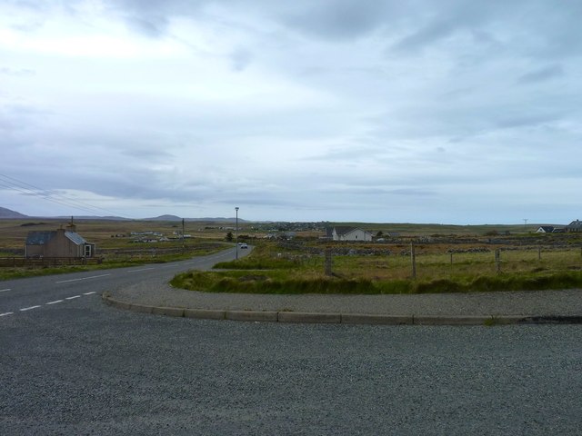
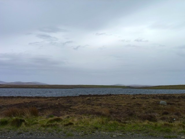
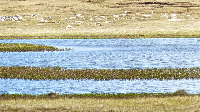
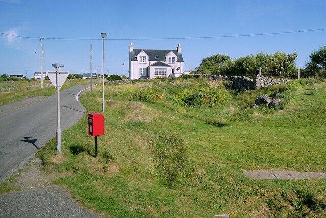
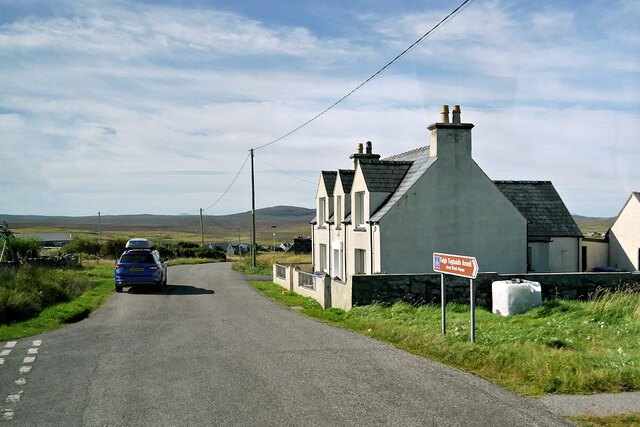
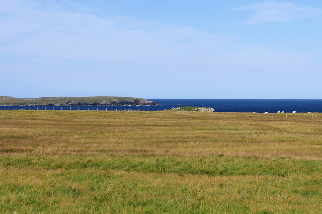
Arnol is a small village located in the county of Ross-shire, in the Highland region of Scotland. Situated on the northwest coast of the Isle of Lewis, it is part of the Outer Hebrides archipelago. The village is surrounded by stunning landscapes, including vast moorlands, rugged hills, and breathtaking seascapes.

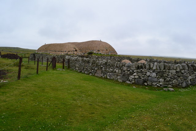
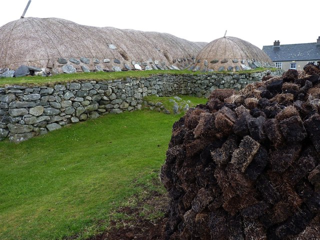
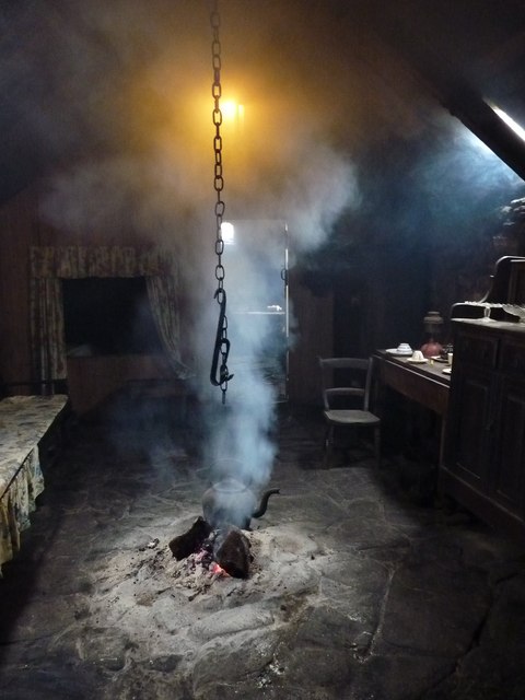
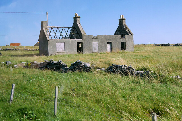
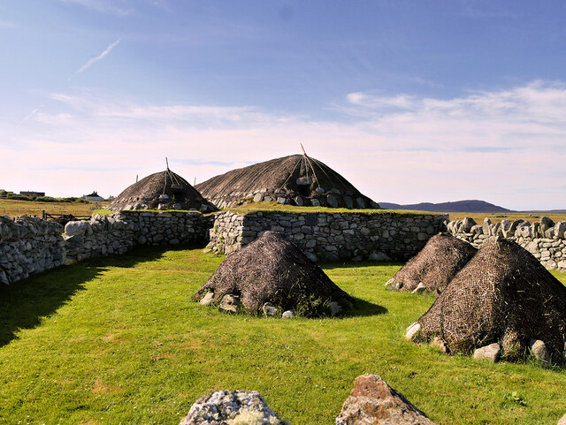
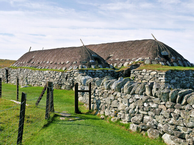
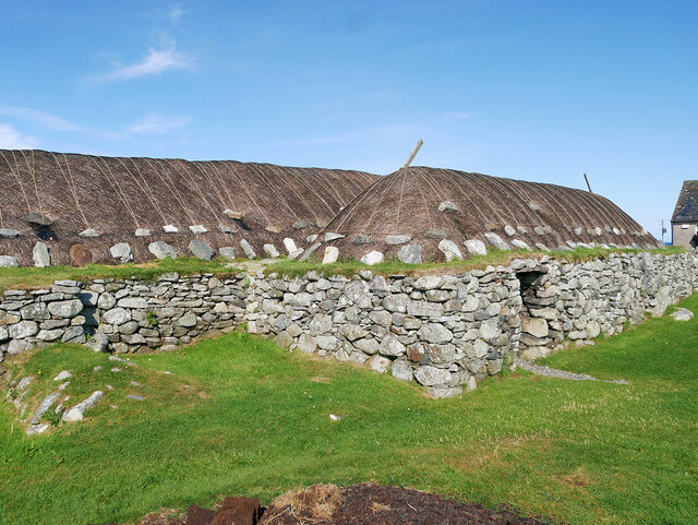
Although Arnol is a relatively small settlement, it boasts a rich history and cultural heritage. One of the notable attractions in the village is the Arnol Blackhouse, a traditional thatched cottage that has been preserved as a museum. This blackhouse provides a fascinating insight into the way of life and living conditions of the local crofters in the 19th and early 20th centuries.

The village itself offers a peaceful and serene environment, with a close-knit community that welcomes visitors with warmth and friendliness. There are a few amenities available, including a local shop and a community hall. The picturesque coastline is a popular spot for fishing, walks, and birdwatching, with a variety of seabirds and marine life to be observed.

For those looking to explore the wider area, Arnol serves as an excellent base for discovering the natural wonders of the Isle of Lewis. Nearby attractions include the famous Callanish Standing Stones, the stunning white sandy beaches of Uig, and the dramatic cliffs of the Butt of Lewis. The village is also within reach of the main town of Stornoway, where visitors can find a wider range of amenities, including restaurants, shops, and accommodations.

Overall, Arnol is a charming village that offers visitors a glimpse into the past while surrounded by the beauty of the Scottish Highlands and the rugged coastline of the Outer Hebrides.

If you have any feedback on the listing, please let us know in the comments section below.

Arnol Images

Images are sourced within 2km of 58.343269/-6.59653 or Grid Reference NB3148. Thanks to Geograph Open Source API. All images are credited.

Restored Blackhouse at Arnol
Fuel supplies A stack of peat behind the Black House in Arnol.
Fuel supplies
A stack of peat behind the Black House in Arnol.
Central heating Black houses were heated by a peat fire on the floor of the living room. The smoke escaped through a hole in the roof. This example in Arnol village of a black house, which was lived in by a crofting family until 1966, is now maintained by Historic Scotland who still keep the home fires burning in the traditional way, with peat.
Central heating
Black houses were heated by a peat fire on the floor of the living room. The smoke escaped through a hole in the roof. This example in Arnol village of a black house, which was lived in by a crofting family until 1966, is now maintained by Historic Scotland who still keep the home fires burning in the traditional way, with peat.
Road junction The A858 where it passes the side road from Arnol.
Road junction
The A858 where it passes the side road from Arnol.
Loch Urghag A moorland loch east of Arnol.
Loch Urghag
A moorland loch east of Arnol.
Loch na Muilne RSPB reserve Just so that Anne <a href="https://www.geograph.org.uk/photo/1344584">NB3149 : Loch na Muilne</a> doesn't feel too deprived, you can see red-necked phalaropes on the loch, if you're very lucky! A family who had been sharing the hide with us had almost reached their camper van a quarter of a mile away when two birds appeared from out of the bogbean and swam across several yards of open water to the next patch. If you zoom in and look to the near side of the flat water off the further mat of bogbean, you can just about make out the birds - honest!
Loch na Muilne RSPB reserve
Just so that Anne NB3149 : Loch na Muilne doesn't feel too deprived, you can see red-necked phalaropes on the loch, if you're very lucky! A family who had been sharing the hide with us had almost reached their camper van a quarter of a mile away when two birds appeared from out of the bogbean and swam across several yards of open water to the next patch. If you zoom in and look to the near side of the flat water off the further mat of bogbean, you can just about make out the birds - honest!
Replica Shieling There are hundreds of shielings in the Western Isles and this replica provides a wonderful insight into what life would have been like for those living in them during the summer months.
Replica Shieling
There are hundreds of shielings in the Western Isles and this replica provides a wonderful insight into what life would have been like for those living in them during the summer months.
Replica Shieling A shieling, or airigh, was a small hut on the moors where families would stay in the summer months while their cattle grazed on the open moors. Most families had their own airigh where some family members, typically the mother, grandmother or aunt with the younger children would migrate to annually form May until July with their cattle including milking or in-calf cows. At weekends the schoolchildren and other family members who would be working at the main croft during the week would visit the airigh to enjoy some time off. Several people would stay in these tiny buildings and it is hard to imagine how they managed. This beautiful replica has been fitted out as it would have been with, essentially, a bed and little else. Most cooking would have been done outside but it must have been cramped in the rain.
Replica Shieling
A shieling, or airigh, was a small hut on the moors where families would stay in the summer months while their cattle grazed on the open moors. Most families had their own airigh where some family members, typically the mother, grandmother or aunt with the younger children would migrate to annually form May until July with their cattle including milking or in-calf cows. At weekends the schoolchildren and other family members who would be working at the main croft during the week would visit the airigh to enjoy some time off. Several people would stay in these tiny buildings and it is hard to imagine how they managed. This beautiful replica has been fitted out as it would have been with, essentially, a bed and little else. Most cooking would have been done outside but it must have been cramped in the rain.
Replica Shieling interior A shieling, or airigh, was a small hut on the moors where families would stay in the summer months while their cattle grazed on the open moors. Most families had their own airigh where some family members, typically the mother, grandmother or aunt with the younger children would migrate to annually form May until July with their cattle including milking or in-calf cows. At weekends the schoolchildren and other family members who would be working at the main croft during the week would visit the airigh to enjoy some time off. Several people would stay in these tiny buildings and it is hard to imagine how they managed. This beautiful replica has been fitted out as it would have been with, essentially, a bed and little else. Most cooking would have been done outside but it must have been cramped in the rain.
Replica Shieling interior
A shieling, or airigh, was a small hut on the moors where families would stay in the summer months while their cattle grazed on the open moors. Most families had their own airigh where some family members, typically the mother, grandmother or aunt with the younger children would migrate to annually form May until July with their cattle including milking or in-calf cows. At weekends the schoolchildren and other family members who would be working at the main croft during the week would visit the airigh to enjoy some time off. Several people would stay in these tiny buildings and it is hard to imagine how they managed. This beautiful replica has been fitted out as it would have been with, essentially, a bed and little else. Most cooking would have been done outside but it must have been cramped in the rain.
Scottish Salmon Fish Farm Fish farm situated on Abhainn Èirearrigh where it flows out of Loch Urghag.
Scottish Salmon Fish Farm
Fish farm situated on Abhainn Èirearrigh where it flows out of Loch Urghag.
Fish Farm Sales hut
Fish Farm Sales hut
Arnol, East Road End The junction of the road from Arnol with the A858.
Arnol, East Road End
The junction of the road from Arnol with the A858.
Derelict House at Arnol Arnol (Scottish Gaelic: Àrnol) is a small settlement on the west coast of the Isle of Lewis. Once a thriving township with over forty crofts, it now has a much lower number of active crofters and several ruined houses can be seen in the area.
Derelict House at Arnol
Arnol (Scottish Gaelic: Àrnol) is a small settlement on the west coast of the Isle of Lewis. Once a thriving township with over forty crofts, it now has a much lower number of active crofters and several ruined houses can be seen in the area.
Local Road at Arnol Arnol (Scottish Gaelic: Àrnol) is a small settlement on the west coast of the Isle of Lewis. Once a thriving township with over forty crofts, it now has a much lower number of active crofters and several ruined houses can be seen in the area.
Local Road at Arnol
Arnol (Scottish Gaelic: Àrnol) is a small settlement on the west coast of the Isle of Lewis. Once a thriving township with over forty crofts, it now has a much lower number of active crofters and several ruined houses can be seen in the area.
View towards Eilean Arnol Looking across the fields from the Arnol Blackhouse car park.
View towards Eilean Arnol
Looking across the fields from the Arnol Blackhouse car park.
The Arnol Blackhouse (taigh-dubh) Arnol (Scottish Gaelic: Àrnol) is a small settlement on the west coast of the Isle of Lewis. Once a thriving township with over forty crofts, it now has a much lower number of active crofters and several ruined houses can be seen in the area.

Taigh Tughaidh Àrnoil (The Arnol Blackhouse Museum) is at the north end of Arnol township on a site managed by Historic Environment Scotland and designated as a scheduled monument (SM90022 <span class="nowrap"><a title="https://portal.historicenvironment.scot/designation/SM90022" rel="nofollow ugc noopener" href="https://portal.historicenvironment.scot/designation/SM90022">Link</a><img style="margin-left:2px;" alt="External link" title="External link - shift click to open in new window" src="https://s1.geograph.org.uk/img/external.png" width="10" height="10"/></span> Historic Environment Scotland). The site comprises a group of domestic buildings including two traditional blackhouses and two stone-and-mortar-built croft houses (whitehouses).

The two blackhouses were both built around 1880. Blackhouse no 42, on the east side of the road, is one of the best preserved blackhouses anywhere. It was one of the last to be built without windows or a chimney, linking it to medieval buildings that used an open hearth.  Since being taken into state care in 1962, it has been restored to give visitors a sense of rural life over the last century. The byre roof was rebuilt in 1990. Adjacent to this, is a single-storey croft house into which the inhabitants of the blackhouse moved around 1962. This building is now uninhabited and has been refurbished internally for use as a visitor centre. On the western side of the road, Blackhouse no 39 was abandoned much earlier and now stands roofless. The croft house associated with this blackhouse was built in the 1920s and lies next to the road. It has two storeys and is covered by a pitched roof covered with felt.

More information  can be found in the Historic Environment Scotland Statement of Significance <span class="nowrap"><a title="https://app-hes-pubs-prod-neu-01.azurewebsites.net/api/file/e6e95e8d-991d-4204-b53a-b08800e28117" rel="nofollow ugc noopener" href="https://app-hes-pubs-prod-neu-01.azurewebsites.net/api/file/e6e95e8d-991d-4204-b53a-b08800e28117">Link</a><img style="margin-left:2px;" alt="External link" title="External link - shift click to open in new window" src="https://s1.geograph.org.uk/img/external.png" width="10" height="10"/></span> (pdf file).
The Arnol Blackhouse (taigh-dubh)
Arnol (Scottish Gaelic: Àrnol) is a small settlement on the west coast of the Isle of Lewis. Once a thriving township with over forty crofts, it now has a much lower number of active crofters and several ruined houses can be seen in the area. Taigh Tughaidh Àrnoil (The Arnol Blackhouse Museum) is at the north end of Arnol township on a site managed by Historic Environment Scotland and designated as a scheduled monument (SM90022 LinkExternal link Historic Environment Scotland). The site comprises a group of domestic buildings including two traditional blackhouses and two stone-and-mortar-built croft houses (whitehouses). The two blackhouses were both built around 1880. Blackhouse no 42, on the east side of the road, is one of the best preserved blackhouses anywhere. It was one of the last to be built without windows or a chimney, linking it to medieval buildings that used an open hearth. Since being taken into state care in 1962, it has been restored to give visitors a sense of rural life over the last century. The byre roof was rebuilt in 1990. Adjacent to this, is a single-storey croft house into which the inhabitants of the blackhouse moved around 1962. This building is now uninhabited and has been refurbished internally for use as a visitor centre. On the western side of the road, Blackhouse no 39 was abandoned much earlier and now stands roofless. The croft house associated with this blackhouse was built in the 1920s and lies next to the road. It has two storeys and is covered by a pitched roof covered with felt. More information can be found in the Historic Environment Scotland Statement of Significance LinkExternal link (pdf file).
Blackhouse, No 42 Arnol The roof is made from heathery turf, which is weighed down by rocks and ropes. Few trees grow in the area because of the boggy landscape and high winds; islanders needed to be resourceful with what was available
Blackhouse, No 42 Arnol
The roof is made from heathery turf, which is weighed down by rocks and ropes. Few trees grow in the area because of the boggy landscape and high winds; islanders needed to be resourceful with what was available
Taigh-Dubh Arnoil Blackhouse Museum The restored blackhouse, 42 Arnol.
Taigh-Dubh Arnoil Blackhouse Museum
The restored blackhouse, 42 Arnol.
Show me another place!

Arnol is located at Grid Ref: NB3148 (Lat: 58.343269, Lng: -6.59653)

Unitary Authority: Na h-Eileanan an Iar

Police Authority: Highlands and Islands

What 3 Words

///slimming.tolerates.curable. Near Carloway, Na h-Eileanan Siar

Nearby Locations

Loch Sgeireach Arnol

Related Wikis

Arnol

Arnol (Scottish Gaelic: Àrnol) is a small village typical of many settlements of the west coast of the Isle of Lewis, in the Outer Hebrides, Scotland....

Bragar

Bragar (Scottish Gaelic: Bràgar, pronounced [braːgər]) is a village on the west side of the Isle of Lewis in the Outer Hebrides, Scotland, 14 miles (23...

Brue

Brue (Scottish Gaelic: Brù) is a village on the Isle of Lewis in the West Side district, in the Outer Hebrides, Scotland. It is a crofting township and...

Mullen Bridge

Mullen Bridge is an old bridge crossing the Royal Canal in Maynooth in County Kildare, Ireland. It was built between 1790 and 1800.The bridge used to carry...

Nearby Amenities

Located within 500m of 58.343269,-6.59653
Passing Place
Lat/Long: 58.3444096/-6.5962487
Passing Place
Lat/Long: 58.3397723/-6.5996156
Telephone
Booth: KX100
Covered: booth
Source: survey
Lat/Long: 58.3432058/-6.5966642
Bus Stop
Arnol
Naptan AtcoCode: 6010731518
Naptan Bearing: NE
Naptan CommonName: Arnol
Naptan Indicator: Phone Box
Naptan Landmark: bus shelter
Naptan NaptanCode: 94723987
Naptan Street: Phone Box
Naptan Verified: no
Source: naptan_import
Lat/Long: 58.343196/-6.5966164
Passing Place
Lat/Long: 58.3468112/-6.5974869
Post Box
Collection Times: Mo-Fr 09:00; Sa 09:00
Operator: Royal Mail
Post Box Type: lamp
Ref: LH086 Arnol
Royal Cypher: scottish_crown
Source: survet
Lat/Long: 58.3404257/-6.5924675
Passing Place
Lat/Long: 58.341675/-6.5978299
Passing Place
Lat/Long: 58.3423984/-6.5971637
Passing Place
Lat/Long: 58.3462273/-6.5969057
Barrier: cattle_grid
Lat/Long: 58.3429649/-6.5971748
Àrnol
Name En: Arnol
Name Gd: Àrnol
Place: village
Wikidata: Q2188244
Wikipedia: en:Arnol
Lat/Long: 58.3430838/-6.5964507
Barrier: cattle_grid
Lat/Long: 58.3416079/-6.5940748
Barrier: cattle_grid
Lat/Long: 58.3392987/-6.5976803
Passing Place
Lat/Long: 58.3401632/-6.5991622
Passing Place
Lat/Long: 58.3438951/-6.5963754
Turning Circle
Lat/Long: 58.3451479/-6.5955573
Passing Place
Lat/Long: 58.3472931/-6.5977286
Barrier: cattle_grid
Lat/Long: 58.3419988/-6.5952859
Noexit: yes
Lat/Long: 58.3430129/-6.5945391
Power: pole
Lat/Long: 58.3421928/-6.5888737
Power: pole
Lat/Long: 58.3418695/-6.5905347
Power: pole
Lat/Long: 58.3416095/-6.5920972
Power: pole
Lat/Long: 58.3413469/-6.5936793
Power: pole
Lat/Long: 58.3411141/-6.5951037
Power: pole
Lat/Long: 58.3407998/-6.5969915
Power: pole
Lat/Long: 58.3405204/-6.5986451
Power: pole
Lat/Long: 58.3401567/-6.6002001
Power: pole
Lat/Long: 58.3401681/-6.6005183
Power: pole
Lat/Long: 58.3399836/-6.598825
Power: pole
Lat/Long: 58.3399448/-6.5995668
Power: pole
Lat/Long: 58.3395541/-6.5999167
Power: pole
Lat/Long: 58.3392243/-6.6001977
Power: pole
Lat/Long: 58.3473752/-6.5950791
Power: pole
Lat/Long: 58.3465281/-6.5948795
Power: pole
Lat/Long: 58.345844/-6.5947242
Power: pole
Lat/Long: 58.3451133/-6.5945468
Power: pole
Lat/Long: 58.3444045/-6.5943743
Power: pole
Lat/Long: 58.3436324/-6.5941993
Power: pole
Lat/Long: 58.3433272/-6.5941254
Power: pole
Lat/Long: 58.3431267/-6.5945542
Power: pole
Lat/Long: 58.34289/-6.5950298
Power: pole
Lat/Long: 58.3426274/-6.5956434
Power: pole
Lat/Long: 58.3456668/-6.5955843
Power: pole
Lat/Long: 58.3423118/-6.5968461
Power: pole
Lat/Long: 58.3400146/-6.5939159
Power: pole
Lat/Long: 58.3401893/-6.5929474
Power: pole
Lat/Long: 58.3402914/-6.5924668
Power: pole
Lat/Long: 58.3406847/-6.5930558
Power: pole
Lat/Long: 58.3417078/-6.5944655
Power: pole
Lat/Long: 58.3421864/-6.5951308
Power: pole
Lat/Long: 58.3429754/-6.5961437
Power: pole
Lat/Long: 58.3433026/-6.5966169
Power: pole
Lat/Long: 58.3437682/-6.5965282
Power: pole
Lat/Long: 58.3441355/-6.5964863
Power: pole
Lat/Long: 58.343331/-6.5958086
Power: pole
Lat/Long: 58.3417699/-6.5956829
Power: pole
Lat/Long: 58.3411581/-6.5965306
Power: pole
Lat/Long: 58.3414504/-6.5961215
Barrier: cattle_grid
Lat/Long: 58.3414226/-6.5887328
The data included in this document is from www.openstreetmap.org. The data is made available under ODbL.

Have you been to Arnol?

Leave your review of Arnol below (or comments, questions and feedback).