Flat Wood

Wood, Forest in Yorkshire

England

Flat Wood

On Pool Hill This hill is classed as a TumP. It's an excellent viewpoint.
On Pool Hill Credit: David Bremner

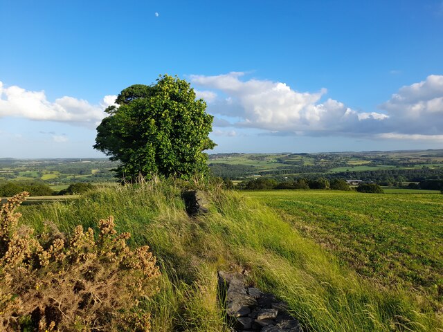
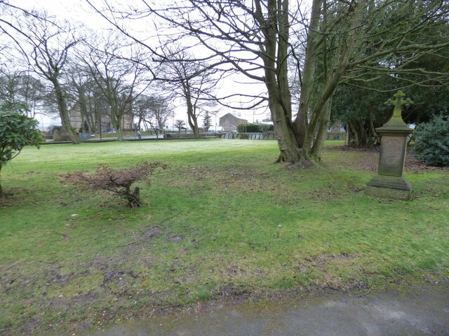
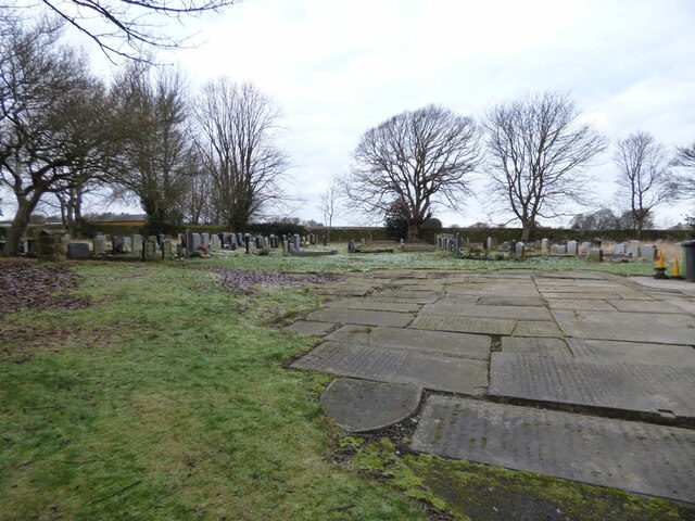
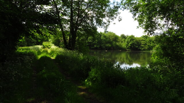
Flat Wood is a picturesque woodland located in the county of Yorkshire, England. Situated in the heart of the countryside, this forested area spans approximately 100 acres, making it a haven for nature enthusiasts and outdoor adventurers alike.

The wood is predominantly composed of deciduous trees, such as oak, beech, and birch, which create a stunning canopy of green during the warmer months. The forest floor is covered with a rich tapestry of wildflowers, ferns, and mosses, adding to the wood's beauty and biodiversity.

A network of well-maintained trails meanders through Flat Wood, providing visitors with the opportunity to explore the area on foot or by bike. These paths lead to hidden clearings, babbling brooks, and small ponds, allowing for peaceful moments of reflection and wildlife observation.

Flat Wood is home to a variety of animal species, including deer, foxes, rabbits, and a plethora of birdlife. Keen birdwatchers may spot species such as woodpeckers, owls, and thrushes. The tranquil ambiance of the wood also attracts numerous butterflies and insects, making it a haven for wildlife enthusiasts and photographers.

The wood is open to the public year-round, with no admission fee, and offers amenities such as picnic areas and benches for visitors to relax and enjoy the natural surroundings. Furthermore, educational programs and guided tours are available for those interested in learning more about the local flora and fauna.

Overall, Flat Wood in Yorkshire is a hidden gem, offering a peaceful retreat for individuals seeking solace in nature and the opportunity to immerse themselves in the beauty of a traditional English woodland.

If you have any feedback on the listing, please let us know in the comments section below.

Flat Wood Images

Images are sourced within 2km of 53.563364/-1.6331187 or Grid Reference SE2407. Thanks to Geograph Open Source API. All images are credited.

On Pool Hill This hill is classed as a TumP. It's an excellent viewpoint.
On Pool Hill
This hill is classed as a TumP. It's an excellent viewpoint.
Old milestone The 6 miles from Barnsley, late 19C West Riding CC, milestone is just west of Coach Gate Lane which leads to the ancient Gunthwaite Hall.   It is on a very narrow verge almost at the Barnsley/Kirklees boundary.  Not well painted but in a very difficult place to work.  It is Grade II listed 1314730.
Old milestone
The 6 miles from Barnsley, late 19C West Riding CC, milestone is just west of Coach Gate Lane which leads to the ancient Gunthwaite Hall. It is on a very narrow verge almost at the Barnsley/Kirklees boundary. Not well painted but in a very difficult place to work. It is Grade II listed 1314730.
Old milestone Vegetation had to be cleared to reveal this West Riding CC milestone.  It is one of 615 set up in 1893/94 for the newly formed West Riding Council all over its extensive 'territory' from Sedbergh in the north west to south of Rotherham and over the Pennines into Saddleworth.   Over half are still in situ.  It is on the south side of the A635 between Denby Lane and Lower Denby Lane.
Old milestone
Vegetation had to be cleared to reveal this West Riding CC milestone. It is one of 615 set up in 1893/94 for the newly formed West Riding Council all over its extensive 'territory' from Sedbergh in the north west to south of Rotherham and over the Pennines into Saddleworth. Over half are still in situ. It is on the south side of the A635 between Denby Lane and Lower Denby Lane.
Old milestone A view of the milestone on the A635 between Denby Lane and Low Denby Lane before the grass had been trodden down.  Grade II listed 1135324.
Old milestone
A view of the milestone on the A635 between Denby Lane and Low Denby Lane before the grass had been trodden down. Grade II listed 1135324.
Old milestone A view of the 8 miles from Barnsley milestone under the arch of the railway viaduct at Denby Dale.  Trains from Barnsley approach from the left and the station is a short distance to the right across the A636 Wakefield Road.
Old milestone
A view of the 8 miles from Barnsley milestone under the arch of the railway viaduct at Denby Dale. Trains from Barnsley approach from the left and the station is a short distance to the right across the A636 Wakefield Road.
Old milestone This is the last late 19C West Riding CC milestone between Barnsley and Shepley Lane Head.   There would have been two more but they are missing.   Many of the metal attachments had the foundry name on the bevel but the ones on this route haven't so we don't know where they were forged.   On this milestone the four fixing points for the attachment to the backing stone can be seen.  Grade II listed 1135325.
Old milestone
This is the last late 19C West Riding CC milestone between Barnsley and Shepley Lane Head. There would have been two more but they are missing. Many of the metal attachments had the foundry name on the bevel but the ones on this route haven't so we don't know where they were forged. On this milestone the four fixing points for the attachment to the backing stone can be seen. Grade II listed 1135325.
Post Box at Upper Denby HD8 236. Royal Mail list this box as 'Upper Denby'.
Post Box at Upper Denby
HD8 236. Royal Mail list this box as 'Upper Denby'.
Old milestone One of the five remaining West Riding CC milestones with a protruding attachment still to be seen on this route, A636, from Wakefield to Denby Dale.  It is at the northeastern end of Denby Dale, although apparently this area was in Skelmanthorpe parish.  It is close to the entrance to Putting Mill Walk.   Grade II listed 1185069.
Old milestone
One of the five remaining West Riding CC milestones with a protruding attachment still to be seen on this route, A636, from Wakefield to Denby Dale. It is at the northeastern end of Denby Dale, although apparently this area was in Skelmanthorpe parish. It is close to the entrance to Putting Mill Walk. Grade II listed 1185069.
St John the Evangelist Church, Upper Denby A handsome building.
St John the Evangelist Church, Upper Denby
A handsome building.
Farm Buildings, Papist Hill Note the fine concrete bin.
Farm Buildings, Papist Hill
Note the fine concrete bin.
St John the Evangelist, Denby - south side The church was built in 1842-3, typically for its time with galleries but no chancel. Equally typical of its time was the removal of the galleries and addition of a chancel and porch in 1900. Grade II listed (list entry 1313363).
St John the Evangelist, Denby - south side
The church was built in 1842-3, typically for its time with galleries but no chancel. Equally typical of its time was the removal of the galleries and addition of a chancel and porch in 1900. Grade II listed (list entry 1313363).
St John the Evangelist, Denby - nave The church was built in 1842-3, typically for its time with galleries but no chancel. Equally typical of its time was the removal of the galleries and addition of a chancel and porch in 1900. Grade II listed (list entry 1313363).
St John the Evangelist, Denby - nave
The church was built in 1842-3, typically for its time with galleries but no chancel. Equally typical of its time was the removal of the galleries and addition of a chancel and porch in 1900. Grade II listed (list entry 1313363).
St John the Evangelist, Denby - chancel The church was built in 1842-3, but this narrow chancel was only added in 1900. Grade II listed (list entry 1313363).
St John the Evangelist, Denby - chancel
The church was built in 1842-3, but this narrow chancel was only added in 1900. Grade II listed (list entry 1313363).
St John the Evangelist, Denby - war memorial The war memorial takes the form of wooden panelling between the tower and nave, bearing the names of twenty-four men who died in the First World War, and two in the Second. Beneath the names is written 'While they sleep, Lord Jesus, look on them. When they rise, receive them'.
St John the Evangelist, Denby - war memorial
The war memorial takes the form of wooden panelling between the tower and nave, bearing the names of twenty-four men who died in the First World War, and two in the Second. Beneath the names is written 'While they sleep, Lord Jesus, look on them. When they rise, receive them'.
St John the Evangelist, Denby - font A slender stone font with wooden cover.
St John the Evangelist, Denby - font
A slender stone font with wooden cover.
St John the Evangelist, Denby - front churchyard Nearly all the gravestones have been removed from the area to the front of the church, unlike the rear where they are all still in place.
St John the Evangelist, Denby - front churchyard
Nearly all the gravestones have been removed from the area to the front of the church, unlike the rear where they are all still in place.
St John the Evangelist, Denby - rear churchyard Immediately west of the church building, old gravestones have been laid flat as ledgers. Beyond that, nearly all the gravestones are still in place. The churchyard is now full, with few if any burials having taken place since 1975.
St John the Evangelist, Denby - rear churchyard
Immediately west of the church building, old gravestones have been laid flat as ledgers. Beyond that, nearly all the gravestones are still in place. The churchyard is now full, with few if any burials having taken place since 1975.
Gunthwaite Dam near Upper Denby
Show me another place!

Flat Wood is located at Grid Ref: SE2407 (Lat: 53.563364, Lng: -1.6331187)

Division: West Riding

Unitary Authority: Kirklees

Police Authority: West Yorkshire

What 3 Words

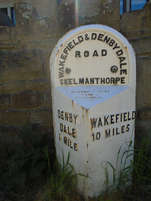
///permanent.loads.blanked. Near Denby Dale, West Yorkshire

Related Wikis

Gunthwaite

Gunthwaite is a hamlet in the Metropolitan Borough of Barnsley in South Yorkshire, England. It is in the civil parish of Gunthwaite and Ingbirchworth and...

Upper Denby

Upper Denby is a small village within the civil parish of Denby Dale, and the borough of Kirklees in West Yorkshire, England. Lying 11 miles (17 km) to...

Denby Dale

Denby Dale is a village and civil parish in the metropolitan borough of Kirklees in West Yorkshire, England. It is 10 miles (17 km) to the south-east of...

Denby Dale Viaduct

Denby Dale Viaduct is a grade II listed railway viaduct in Denby Dale, West Yorkshire, England. The curving viaduct carries the Penistone line over the...

Gunthwaite and Ingbirchworth

Gunthwaite and Ingbirchworth is a civil parish in the Barnsley district, in the county of South Yorkshire, England. It contains the hamlet of Gunthwaite...

Denby Dale railway station

Denby Dale railway station serves the village of Denby Dale, in West Yorkshire, England and the surrounding area. It lies on the Penistone Line 9.5 miles...

Ingbirchworth

Ingbirchworth is a village and former civil parish, now in the parish of Gunthwaite and Ingbirchworth, in the Barnsley district, in the county of South...

Scissett

Scissett is a village in West Yorkshire, England. It is 8 miles (13 km) south-east of Huddersfield and 10 miles (16 km) north-west of Barnsley. According...

Nearby Amenities

Located within 500m of 53.563364,-1.6331187
Barnsley Road at Nether End
Naptan AtcoCode: 450015908
Naptan Bearing: E
Naptan BusStopType: CUS
Naptan CommonName: Barnsley Road at Nether End
Naptan Crossing: Coach Gate Lane
Naptan Landmark: Unknown
Naptan ShortCommonName: Nether End
Naptan Street: Barnsley Road
Naptan Verified: no
Source: naptan_import
Lat/Long: 53.5671932/-1.6316034
Barnsley Road at Nether End
Naptan AtcoCode: 450015909
Naptan Bearing: W
Naptan BusStopType: CUS
Naptan CommonName: Barnsley Road at Nether End
Naptan Crossing: Coach Gate Lane
Naptan Landmark: Unknown
Naptan ShortCommonName: Nether End
Naptan Street: Barnsley Road
Naptan Verified: no
Source: naptan_import
Lat/Long: 53.5670048/-1.6317107
Give Way
Direction: backward
Lat/Long: 53.5671079/-1.6329321
Power: pole
Lat/Long: 53.5669422/-1.6369391
Barrier: stile
Stile: stepover
Lat/Long: 53.5594576/-1.6331681
Barrier: stile
Stile: stepover
Lat/Long: 53.5606438/-1.6342579
Ford: yes
Lat/Long: 53.5646185/-1.6290003
Barrier: stile
Stile: stepover
Lat/Long: 53.5620881/-1.6383201
Barrier: stile
Stile: stepover
Lat/Long: 53.5665154/-1.6355104
Barrier: stile
Stile: stepover
Lat/Long: 53.5674245/-1.6323576
Ford: yes
Lat/Long: 53.5645871/-1.6287572
Barrier: stile
Stile: stepover
Lat/Long: 53.5645735/-1.6289797
Barrier: stile
Stile: stepover
Lat/Long: 53.5674672/-1.6324916
Barrier: stile
Stile: stepover
Lat/Long: 53.5672587/-1.6322619
Natural: spring
Lat/Long: 53.5646552/-1.6293293
Barrier: stile
Stile: stepover
Lat/Long: 53.5623202/-1.6349207
Barrier: stile
Stile: stepover
Lat/Long: 53.5633747/-1.6282083
Barrier: stile
Stile: stepover
Lat/Long: 53.5600436/-1.6340492
Barrier: stile
Stile: stepover
Lat/Long: 53.5615277/-1.6268012
Barrier: stile
Stile: stepover
Lat/Long: 53.5610284/-1.6268935
Barrier: stile
Step Count: 3
Stile: stepover
Lat/Long: 53.5644308/-1.6392391
The data included in this document is from www.openstreetmap.org. The data is made available under ODbL.

Have you been to Flat Wood?

Leave your review of Flat Wood below (or comments, questions and feedback).