Buck's Hill Plantation

Wood, Forest in Durham

England

Buck's Hill Plantation

Blackburn Fell A view of the fell from the Tyne-Wear Trail.
Blackburn Fell Credit: Steve McShane

Buck's Hill Plantation, located in Durham, is a sprawling woodland area encompassing vast stretches of forest and woodlands. Spanning approximately 200 acres, this plantation is a haven for nature enthusiasts and those seeking a tranquil escape from the bustling city life.

The plantation boasts a diverse range of flora and fauna, with towering trees, vibrant wildflowers, and a myriad of plant species that thrive in the fertile soil. The woodland is predominantly composed of hardwood trees such as oak, hickory, and maple, creating a picturesque landscape that changes with the seasons. In the spring, the forest is adorned with a colorful display of blossoms, while in the fall, the foliage transforms into a stunning tapestry of reds, yellows, and oranges.

The woodland is home to a rich variety of wildlife, including deer, foxes, squirrels, and a plethora of bird species. Birdwatchers will delight in the opportunity to spot rare and migratory birds in their natural habitat. The plantation also features several hiking trails, allowing visitors to explore the woodlands at their own pace and discover the hidden treasures within.

Buck's Hill Plantation is not only a sanctuary for nature, but it also holds historical significance. The property dates back several centuries and has been meticulously preserved to maintain its original charm. Visitors can learn about the plantation's history through guided tours or by perusing the informational plaques scattered throughout the area.

In conclusion, Buck's Hill Plantation in Durham is a captivating destination for those seeking solace in nature. With its breathtaking woodlands, diverse wildlife, and rich historical background, it offers a truly immersive experience for all who visit.

If you have any feedback on the listing, please let us know in the comments section below.

Buck's Hill Plantation Images

Images are sourced within 2km of 54.937721/-1.6693433 or Grid Reference NZ2160. Thanks to Geograph Open Source API. All images are credited.

Blackburn Fell A view of the fell from the Tyne-Wear Trail.
Blackburn Fell
A view of the fell from the Tyne-Wear Trail.
The Marquis Of Granby The pub is on the Lobley Hill to Sunniside road.
The Marquis Of Granby
The pub is on the Lobley Hill to Sunniside road.
The Birches The Birches housing estate, just off Pennyfine Road in Sunniside.
The Birches
The Birches housing estate, just off Pennyfine Road in Sunniside.
Derelict farmhouse, Clover Hill On the road to Sunniside, crossing Whickham Fell. For more info and another photo see:
<span class="nowrap"><a title="http://www.sunnisidelocalhistorysociety.co.uk/hole-lane.html" rel="nofollow ugc noopener" href="http://www.sunnisidelocalhistorysociety.co.uk/hole-lane.html">Link</a><img style="margin-left:2px;" alt="External link" title="External link - shift click to open in new window" src="https://s1.geograph.org.uk/img/external.png" width="10" height="10"/></span>
Derelict farmhouse, Clover Hill
On the road to Sunniside, crossing Whickham Fell. For more info and another photo see: LinkExternal link
Sandy Lonnen at the junction with Hole Lane Sunniside Oliver Cromwell is alleged to have marched up Sandy and Clockburn Lonnen with his army. Lonnen is the local word for lane.
Sandy Lonnen at the junction with Hole Lane Sunniside
Oliver Cromwell is alleged to have marched up Sandy and Clockburn Lonnen with his army. Lonnen is the local word for lane.
The Potters Wheel, Sunniside
Hill Head Looking towards Gateshead and Newcastle from Hill Head Farm near Sunniside.
Hill Head
Looking towards Gateshead and Newcastle from Hill Head Farm near Sunniside.
Sunniside Station,Tanfield Railway
Platform, Sunniside station Taken from an open window on a Tanfield Railway train.
Platform, Sunniside station
Taken from an open window on a Tanfield Railway train.
Pond, Cuthbert's Hill
View west beside Hole Lane Hole Lane runs east from Fellside Road in Whickham to Sunnisdie. Long Hill to the left.
View west beside Hole Lane
Hole Lane runs east from Fellside Road in Whickham to Sunnisdie. Long Hill to the left.
A6076 Grove Terrace near Sunniside Station
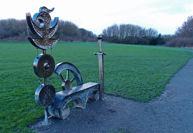
Sunniside park, Whickham Fell Modern sculpture beside the path.
Sunniside park, Whickham Fell
Modern sculpture beside the path.
The Marquis of Granby, Streetgate On Gateshead Road. There has been a pub here since the mid C19 at least and probably before then. It is on the old Toll Road from Gateshead to Burnopfield and as it's part way up a bank, may have been used a resting and watering place for horse drawn vehicles. The pub was rebuilt in 1905 and this is the building that stands today.
The Marquis of Granby, Streetgate
On Gateshead Road. There has been a pub here since the mid C19 at least and probably before then. It is on the old Toll Road from Gateshead to Burnopfield and as it's part way up a bank, may have been used a resting and watering place for horse drawn vehicles. The pub was rebuilt in 1905 and this is the building that stands today.
Shepton Cottages, Streetgate View looking north up Gateshead Road, the main A692 through the village.
Shepton Cottages, Streetgate
View looking north up Gateshead Road, the main A692 through the village.
East Farm, Streetgate There was a farm here for many years, but it ceased to be a working one in the 1990's, when the buildings were converted to residential.
East Farm, Streetgate
There was a farm here for many years, but it ceased to be a working one in the 1990's, when the buildings were converted to residential.
The former Rose pub, Streetgate Now a restaurant, this pub dates from the mid C19. Called The Rose, Shamrock, and Thistle for many years, it was much altered and enlarged in the 1960s and  changed its name to The Rose in 1987.
The former Rose pub, Streetgate
Now a restaurant, this pub dates from the mid C19. Called The Rose, Shamrock, and Thistle for many years, it was much altered and enlarged in the 1960s and changed its name to The Rose in 1987.
The Rising Sun at Sunniside Pub on the A692, the main road through the village. The pub is one of the oldest buildings in the village, and dates back to 1837. It was originally called The Sun, and I believe has recently reverted to the old name.
The Rising Sun at Sunniside
Pub on the A692, the main road through the village. The pub is one of the oldest buildings in the village, and dates back to 1837. It was originally called The Sun, and I believe has recently reverted to the old name.
Show me another place!

Buck's Hill Plantation is located at Grid Ref: NZ2160 (Lat: 54.937721, Lng: -1.6693433)

Unitary Authority: Gateshead

Police Authority: Northumbria

What 3 Words

///backs.pounds.pots. Near Whickham, Tyne & Wear

Related Wikis

Whickham F.C.

Whickham Football Club are an English football club based in Whickham, Tyne and Wear, playing in the Northern League Division One in the English football...

Whickham

Whickham is a village in Tyne and Wear, North East England, within the Metropolitan Borough of Gateshead. The village is on high ground overlooking the...

Whickham School

Whickham School is a coeducational secondary school and sixth form located in Whickham (near Gateshead) in Tyne and Wear, England.Formerly Whickham Comprehensive...

Dunston Hill Hospital

Dunston Hill Hospital was a hospital in Gateshead, Tyne and Wear. It was managed by Gateshead Health NHS Foundation Trust. == History == The hospital had...

Sunniside, Gateshead

Sunniside is a village in the Metropolitan Borough of Gateshead, which is located around 5.5 miles (9 km) from Newcastle upon Tyne. Prior to the creation...

Kingsmeadow Community Comprehensive School

Kingsmeadow Community Comprehensive School is a coeducational secondary school and sixth form based in Dunston, Metropolitan Borough of Gateshead. It was...

Emmanuel College, Gateshead

Emmanuel College is a secondary school and sixth form college (years 7-13) based in Gateshead, England. It was founded in 1990 as a City Technology College...

Swalwell

Swalwell is a village in Gateshead, Tyne and Wear, England, in the United Kingdom. == History == On 27 August 1640, an encampment of soldiers was gathered...

Nearby Amenities

Located within 500m of 54.937721,-1.6693433
Bus Stop
Broom Lane
Bench: no
Bin: yes
Bus: yes
Departures Board: timetable
Local Ref: S
Naptan AtcoCode: 410000014164
Naptan Bearing: S
Naptan CommonName: BROOM LANE-BROADPOOL TERRACE-S/B
Naptan Indicator: S
Naptan Landmark: OUTSIDE BROADPOOL TERRACE
Naptan NaptanCode: twrawtjm
Naptan PlusbusZoneRef: NWCSTLE
Naptan Street: BROOM LANE
Naptan Verified: no
Public Transport: platform
Shelter: yes
Source: naptan_import
Lat/Long: 54.9405741/-1.6712767
Bus Stop
BROOM LANE-SCHOOL-S/B
Bench: no
Bin: no
Bus: yes
Local Ref: S
Naptan AtcoCode: 410000014165
Naptan Bearing: S
Naptan CommonName: BROOM LANE-SCHOOL-S/B
Naptan Indicator: S
Naptan Landmark: ENTRANCETO WASHINGWELL PRIMARY SCHOOL
Naptan NaptanCode: twrawtjp
Naptan PlusbusZoneRef: NWCSTLE
Naptan Street: BROOM LANE
Naptan Verified: no
Public Transport: platform
Shelter: no
Source: naptan_import
Lat/Long: 54.9388819/-1.6704397
Bus Stop
BROOM LANE-FARM-W/B
Bench: no
Bin: no
Bus: yes
Lit: yes
Local Ref: SW
Naptan AtcoCode: 410000014166
Naptan Bearing: SW
Naptan CommonName: BROOM LANE-FARM-W/B
Naptan Indicator: SW
Naptan Landmark: OUTSIDE ENTRANCE TO MARSHALL LANDS FARM
Naptan NaptanCode: twrawtjt
Naptan PlusbusZoneRef: NWCSTLE
Naptan Street: BROOM LANE
Naptan Verified: no
Public Transport: platform
Shelter: no
Source: naptan_import
Tactile Paving: no
Lat/Long: 54.9370175/-1.6720237
Bus Stop
BROOM LANE-CORNMOOR ROAD-E/B
Bench: no
Bin: no
Bus: yes
Local Ref: E
Naptan AtcoCode: 410000014167
Naptan Bearing: E
Naptan CommonName: BROOM LANE-CORNMOOR ROAD-E/B
Naptan Indicator: E
Naptan Landmark: OUTSIDE CORNMOOR ROAD JUNCTION
Naptan NaptanCode: twrawtjw
Naptan PlusbusZoneRef: NWCSTLE
Naptan Street: BROOM LANE
Naptan Verified: no
Public Transport: platform
Shelter: yes
Source: naptan_import
Lat/Long: 54.9365377/-1.6740723
Bus Stop
BROOM LANE-TETHERCOCK COURT-N/B
Local Ref: N
Naptan AtcoCode: 410000014168
Naptan Bearing: N
Naptan CommonName: BROOM LANE-TETHERCOCK COURT-N/B
Naptan Indicator: N
Naptan Landmark: OPPOSITE ENTRANCE TO WASHINGWELL PRIMARY SCHOOL
Naptan NaptanCode: twrawtma
Naptan PlusbusZoneRef: NWCSTLE
Naptan Street: BROOM LANE
Naptan Verified: no
Shelter: yes
Source: naptan_import
Lat/Long: 54.9394047/-1.6708336
Bus Stop
BROOM LANE-BROOM CLOSE-N/B
Bench: yes
Bin: yes
Check Date Bench: 2022-07-15
Covered: yes
Local Ref: N
Naptan AtcoCode: 410000014169
Naptan Bearing: N
Naptan CommonName: BROOM LANE-BROOM CLOSE-N/B
Naptan Indicator: N
Naptan Landmark: OPPOSITE BROADPOOL TERRACE
Naptan NaptanCode: twrawtmd
Naptan PlusbusZoneRef: NWCSTLE
Naptan Street: BROOM LANE
Naptan Verified: no
Shelter: yes
Source: naptan_import
Lat/Long: 54.9412825/-1.6717107
Bus Stop
SOUTHFIELD ROAD-BROOM TERRACE
Bench: no
Bin: no
Bus: yes
Departures Board: no
Local Ref: E
Naptan AtcoCode: 410000014171
Naptan Bearing: E
Naptan CommonName: SOUTHFIELD ROAD-BROOM TERRACE
Naptan Indicator: E
Naptan Landmark: OUTSIDE BROADPOOL TERRACE
Naptan NaptanCode: twrawtmj
Naptan PlusbusZoneRef: NWCSTLE
Naptan Street: SOUTHFIELD ROAD
Naptan Verified: no
Public Transport: platform
Shelter: no
Source: naptan_import
Lat/Long: 54.9409853/-1.6705913
Bus Stop
Watergate Estate
Bench: yes
Bin: yes
Bus: yes
Departures Board: timetable
Local Ref: W
Naptan AtcoCode: 410000014172
Naptan Bearing: W
Naptan CommonName: WHICKHAM WATERGATE ESTATE
Naptan Indicator: W
Naptan Landmark: OUTSIDE THE CRESCENT
Naptan NaptanCode: twrawtmp
Naptan PlusbusZoneRef: NWCSTLE
Naptan Street: WATERGATE ESTATE
Naptan Verified: no
Public Transport: platform
Shelter: yes
Source: naptan_import
Lat/Long: 54.9410134/-1.6675736
Bus Stop
SOUTHFIELD ROAD-SOUTHFIELD TERRACE
Bus: yes
Local Ref: W
Naptan AtcoCode: 410000014173
Naptan Bearing: W
Naptan CommonName: SOUTHFIELD ROAD-SOUTHFIELD TERRACE
Naptan Indicator: W
Naptan Landmark: OUTSIDE BROADPOOL TERRACE
Naptan NaptanCode: twrawtmt
Naptan PlusbusZoneRef: NWCSTLE
Naptan Street: SOUTHFIELD ROAD
Naptan Verified: no
Public Transport: platform
Shelter: yes
Source: naptan_import
Lat/Long: 54.9408786/-1.670884
Bus Stop
Whaggs Lane-Ashfield Road
Bench: no
Bin: no
Bus: yes
Lit: yes
Local Ref: S
Naptan AtcoCode: 410000014962
Naptan Bearing: S
Naptan Indicator: S-Bound
Naptan Landmark: Outside Ashfield Road Junction
Naptan NaptanCode: twrgwdwa
Naptan PlusbusZoneRef: NWCSTLE
Naptan Street: Whaggs Lane
Naptan Verified: no
Public Transport: platform
Shelter: no
Source: naptan_import
Tactile Paving: no
Lat/Long: 54.9375073/-1.6770769
Power: tower
Lat/Long: 54.9351988/-1.6643619
Power: pole
Lat/Long: 54.9370859/-1.6624851
Power: pole
Lat/Long: 54.9386985/-1.662171
Power: pole
Lat/Long: 54.9386063/-1.6621889
Power: pole
Lat/Long: 54.9378371/-1.662335
Power: pole
Lat/Long: 54.9370835/-1.6623342
Power: pole
Lat/Long: 54.9386983/-1.6620196
Power: pole
Lat/Long: 54.937829/-1.6621901
Turning Circle
Lat/Long: 54.9395489/-1.6721963
Turning Circle
Lat/Long: 54.9403336/-1.6724242
Turning Circle
Lat/Long: 54.9408387/-1.6725926
Post Box
Brand: Royal Mail
Brand Wikidata: Q638098
Operator: Royal Mail
Operator Wikidata: Q638098
Post Box Type: pillar
Ref: NE16 357
Royal Cypher: GVIR
Royal Cypher Wikidata: Q33102169
Lat/Long: 54.941391/-1.6715395
Post Box
Ref: NE16 275
Lat/Long: 54.9389208/-1.6742759
Marshall Lands Farm
Place: farm
Source Name: OS OpenData StreetView
Lat/Long: 54.9352418/-1.6697073
Generator Location: roof
Generator Source: solar
Power: generator
Lat/Long: 54.9409083/-1.6693296
Generator Location: roof
Generator Source: solar
Power: generator
Lat/Long: 54.9409117/-1.6692756
Entrance: yes
Lat/Long: 54.9412078/-1.6720081
Defibrillator
Access: yes
Defibrillator Location: Left door pillar
Emergency: defibrillator
Level: 0
Opening Hours: 24/7
Operator: NEAS
Phone: +44 999
Wheelchair: limited
Lat/Long: 54.9412132/-1.6720089
Entrance: main
Lat/Long: 54.9412536/-1.6720151
The data included in this document is from www.openstreetmap.org. The data is made available under ODbL.

Have you been to Buck's Hill Plantation?

Leave your review of Buck's Hill Plantation below (or comments, questions and feedback).