Armitage

Settlement in Staffordshire Lichfield

England

Armitage

Rugeley Road Bridge near Rugeley in Staffordshire Rugeley Road Bridge is No 61A across the Trent and Mersey Canal, and carries the A513 Rugeley Road. (Telephoto image looking east while we wait to go through). This was formerly Armitage Tunnel, until the roof was taken off in 1971 because of subsidence damage.

<span class="nowrap"><a title="https://www.search.staffspasttrack.org.uk/Details.aspx?&ResourceID=13957&SearchType=2&ThemeID=419" rel="nofollow ugc noopener" href="https://www.search.staffspasttrack.org.uk/Details.aspx?&ResourceID=13957&SearchType=2&ThemeID=419">Link</a><img style="margin-left:2px;" alt="External link" title="External link - shift click to open in new window" src="https://s1.geograph.org.uk/img/external.png" width="10" height="10"/></span>
Rugeley Road Bridge near Rugeley in Staffordshire Credit: Roger Kidd

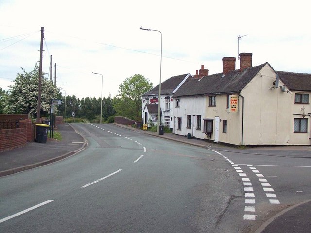
Armitage is a picturesque village located in the county of Staffordshire, England. Situated along the banks of the Trent and Mersey Canal, it is nestled within the Cannock Chase Area of Outstanding Natural Beauty. The village is part of the civil parish of Armitage with Handsacre and enjoys a tranquil setting surrounded by lush green countryside.

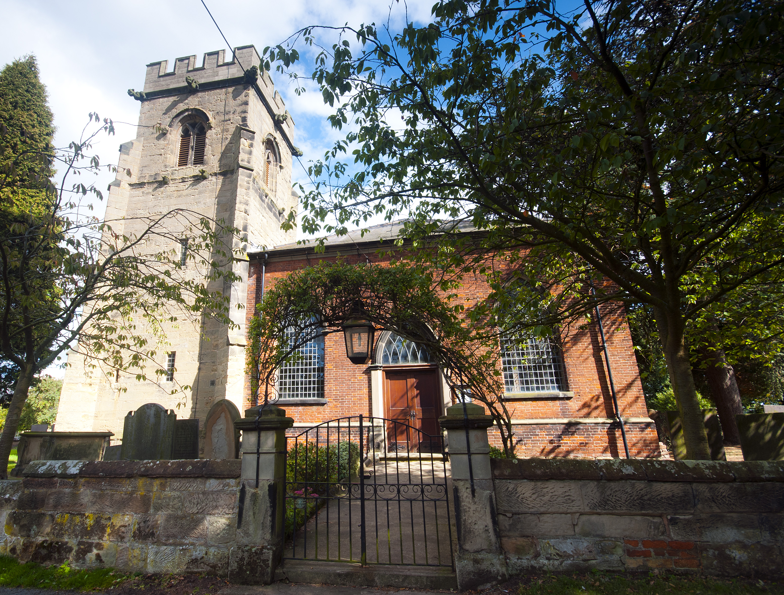
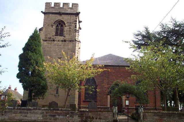
Armitage has a rich history dating back to medieval times, and remnants of its past can still be seen today. The village is renowned for its traditional red-brick cottages and historic buildings, including the impressive St. John the Baptist Church, which dates back to the 13th century. The church features a beautiful tower and stained glass windows, adding to the village's charm.

The village is also known for its pottery heritage, with the Armitage Shanks factory being a prominent local employer for many years. The factory, established in 1817, produced high-quality ceramic sanitary ware and became a household name. Although the factory is no longer operational, its legacy is celebrated in the local community.

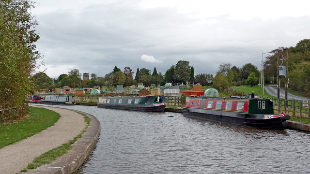
Nature lovers will be delighted by the scenic surroundings of Armitage. The village is a gateway to the stunning Cannock Chase, a designated Area of Outstanding Natural Beauty. This vast woodland offers numerous walking and cycling trails, perfect for outdoor enthusiasts. The nearby Trent and Mersey Canal provides a peaceful spot for leisurely walks, fishing, and boating.

Armitage boasts a close-knit community, with various amenities such as local shops, pubs, and a primary school. The village's convenient location allows easy access to nearby towns and cities, including Lichfield and Stafford, offering a range of additional services and amenities.

Overall, Armitage is an idyllic village that combines its rich history, natural beauty, and community spirit to create a truly delightful place to live or visit.

If you have any feedback on the listing, please let us know in the comments section below.

Armitage Images

Images are sourced within 2km of 52.743794/-1.884129 or Grid Reference SK0716. Thanks to Geograph Open Source API. All images are credited.

Rugeley Road Bridge near Rugeley in Staffordshire Rugeley Road Bridge is No 61A across the Trent and Mersey Canal, and carries the A513 Rugeley Road. (Telephoto image looking east while we wait to go through). This was formerly Armitage Tunnel, until the roof was taken off in 1971 because of subsidence damage.

<span class="nowrap"><a title="https://www.search.staffspasttrack.org.uk/Details.aspx?&ResourceID=13957&SearchType=2&ThemeID=419" rel="nofollow ugc noopener" href="https://www.search.staffspasttrack.org.uk/Details.aspx?&ResourceID=13957&SearchType=2&ThemeID=419">Link</a><img style="margin-left:2px;" alt="External link" title="External link - shift click to open in new window" src="https://s1.geograph.org.uk/img/external.png" width="10" height="10"/></span>
Rugeley Road Bridge near Rugeley in Staffordshire
Rugeley Road Bridge is No 61A across the Trent and Mersey Canal, and carries the A513 Rugeley Road. (Telephoto image looking east while we wait to go through). This was formerly Armitage Tunnel, until the roof was taken off in 1971 because of subsidence damage. LinkExternal link
Former Armitage Tunnel in Staffordshire Rugeley Road Bridge is No 61A across the Trent and Mersey Canal, and carries the A513 Rugeley Road. (Telephoto image looking east while we wait to go through). This was formerly Armitage Tunnel, until the roof was taken off in 1971 because of subsidence damage.

<span class="nowrap"><a title="https://www.search.staffspasttrack.org.uk/Details.aspx?&ResourceID=13957&SearchType=2&ThemeID=419" rel="nofollow ugc noopener" href="https://www.search.staffspasttrack.org.uk/Details.aspx?&ResourceID=13957&SearchType=2&ThemeID=419">Link</a><img style="margin-left:2px;" alt="External link" title="External link - shift click to open in new window" src="https://s1.geograph.org.uk/img/external.png" width="10" height="10"/></span>
Former Armitage Tunnel in Staffordshire
Rugeley Road Bridge is No 61A across the Trent and Mersey Canal, and carries the A513 Rugeley Road. (Telephoto image looking east while we wait to go through). This was formerly Armitage Tunnel, until the roof was taken off in 1971 because of subsidence damage. LinkExternal link
Canal near Armitage in Staffordshire This is the Trent and Mersey Canal east of Rugeley Road Bridge (No 61A formerly Armitage Tunnel), looking east towards Rugeley.
Canal near Armitage in Staffordshire
This is the Trent and Mersey Canal east of Rugeley Road Bridge (No 61A formerly Armitage Tunnel), looking east towards Rugeley.
Canal sentinel east of Armitage By the Trent and Mersey Canal, east of the former Armitage Tunnel.
Canal sentinel east of Armitage
By the Trent and Mersey Canal, east of the former Armitage Tunnel.
Sculpture by the former Armitage Tunnel in Staffordshire By the Trent and Mersey Canal, east of the former Armitage Tunnel. Was he a local "entity" who would light you through the tunnel before it was demolished (circa 1971)?
Sculpture by the former Armitage Tunnel in Staffordshire
By the Trent and Mersey Canal, east of the former Armitage Tunnel. Was he a local "entity" who would light you through the tunnel before it was demolished (circa 1971)?
Canal sentinel sculpture east of Armitage By the Trent and Mersey Canal, east of the former Armitage Tunnel. Was he a mythical local "entity" who would light you through the tunnel before it was demolished (circa 1971)?
Canal sentinel sculpture east of Armitage
By the Trent and Mersey Canal, east of the former Armitage Tunnel. Was he a mythical local "entity" who would light you through the tunnel before it was demolished (circa 1971)?
Site of former Armitage Tunnel in Staffordshire Looking east towards Fradley Junction, Alrewas and Burton upon Trent.

Rugeley Road Bridge is No 61A across the Trent and Mersey Canal, and carries the A513 Rugeley Road. This was formerly Armitage Tunnel, until the roof was taken off in 1971 because of subsidence damage.
Site of former Armitage Tunnel in Staffordshire
Looking east towards Fradley Junction, Alrewas and Burton upon Trent. Rugeley Road Bridge is No 61A across the Trent and Mersey Canal, and carries the A513 Rugeley Road. This was formerly Armitage Tunnel, until the roof was taken off in 1971 because of subsidence damage.
Bridge 61A/Armitage Tunnel in Staffordshire Looking east towards Fradley Junction, Alrewas and Burton upon Trent.

Rugeley Road Bridge is No 61A across the Trent and Mersey Canal, and carries the A513 Rugeley Road. This was formerly Armitage Tunnel, until the roof was taken off in 1971 because of subsidence damage.
Bridge 61A/Armitage Tunnel in Staffordshire
Looking east towards Fradley Junction, Alrewas and Burton upon Trent. Rugeley Road Bridge is No 61A across the Trent and Mersey Canal, and carries the A513 Rugeley Road. This was formerly Armitage Tunnel, until the roof was taken off in 1971 because of subsidence damage.
Trent and Mersey Canal near Armitage in Staffordshire Looking east towards Fradley Junction, Alrewas and Burton upon Trent.

Rugeley Road Bridge is No 61A across the Trent and Mersey Canal, and carries the A513 Rugeley Road. This was formerly Armitage Tunnel, until the roof was taken off in 1971 because of subsidence damage.
Trent and Mersey Canal near Armitage in Staffordshire
Looking east towards Fradley Junction, Alrewas and Burton upon Trent. Rugeley Road Bridge is No 61A across the Trent and Mersey Canal, and carries the A513 Rugeley Road. This was formerly Armitage Tunnel, until the roof was taken off in 1971 because of subsidence damage.
Canal near Armitage in Staffordshire Looking east from near Rugeley Road Bridge (No 61A) towards Fradley Junction, Alrewas and Burton upon Trent.
Canal near Armitage in Staffordshire
Looking east from near Rugeley Road Bridge (No 61A) towards Fradley Junction, Alrewas and Burton upon Trent.
Canal near Armitage in Staffordshire Looking east from near Rugeley Road Bridge (No 61A) towards Fradley Junction, Alrewas and Burton upon Trent. That's Park View Cottage on the right, fronting onto the A513 Rugeley Road.
Canal near Armitage in Staffordshire
Looking east from near Rugeley Road Bridge (No 61A) towards Fradley Junction, Alrewas and Burton upon Trent. That's Park View Cottage on the right, fronting onto the A513 Rugeley Road.
Canal by Rugeley Road near Armitage, Staffordshire On the right is the A513 Rugeley Road, leading towards Armitage, Alrewas and Tamworth. The Trent and Mersey Canal leads towards Fradley Junction, Alrewas and Burton upon Trent.
The allotments were very recently established, opening in March 2011.
Canal by Rugeley Road near Armitage, Staffordshire
On the right is the A513 Rugeley Road, leading towards Armitage, Alrewas and Tamworth. The Trent and Mersey Canal leads towards Fradley Junction, Alrewas and Burton upon Trent. The allotments were very recently established, opening in March 2011.
Narrowboat by the allotments near Armitage, Staffordshire Off to the right is the A513 Rugeley Road, leading towards Armitage, Alrewas and Tamworth. The Trent and Mersey Canal leads towards Fradley Junction, Alrewas and Burton upon Trent.
The allotments were very recently established, opening in March 2011.
On the left is the tower of the Church of St John the Baptist.
Narrowboat by the allotments near Armitage, Staffordshire
Off to the right is the A513 Rugeley Road, leading towards Armitage, Alrewas and Tamworth. The Trent and Mersey Canal leads towards Fradley Junction, Alrewas and Burton upon Trent. The allotments were very recently established, opening in March 2011. On the left is the tower of the Church of St John the Baptist.
Allotments near Armitage, Staffordshire Seen from a passing narrowboat, the allotments were very recently established, opening in March 2011. Behind the trees is the tower on the Church of St John the Baptist.
Allotments near Armitage, Staffordshire
Seen from a passing narrowboat, the allotments were very recently established, opening in March 2011. Behind the trees is the tower on the Church of St John the Baptist.
Allotments near Armitage, Staffordshire Seen from a passing narrowboat, the allotments were very recently established, opening in March 2011.
Allotments near Armitage, Staffordshire
Seen from a passing narrowboat, the allotments were very recently established, opening in March 2011.
Allotments near Armitage, Staffordshire Seen from a passing narrowboat, the allotments were very recently established, opening in March 2011.
Allotments near Armitage, Staffordshire
Seen from a passing narrowboat, the allotments were very recently established, opening in March 2011.
Church Bridge near Armitage in Staffordshire Church Bridge is No 61 across the Trent and Mersey Canal. It is a replacement accommodation bridge which has no public right of way across it or into adjacent fields. St John's Church is just visible behind the trees.
Church Bridge near Armitage in Staffordshire
Church Bridge is No 61 across the Trent and Mersey Canal. It is a replacement accommodation bridge which has no public right of way across it or into adjacent fields. St John's Church is just visible behind the trees.
Show me another place!

Armitage is located at Grid Ref: SK0716 (Lat: 52.743794, Lng: -1.884129)

Administrative County: Staffordshire

District: Lichfield

Police Authority: Staffordshire

What 3 Words

///point.tutorial.kiosk. Near Armitage, Staffordshire

Nearby Locations

Armitage

Related Wikis

Armitage

Armitage is a village in Staffordshire, England on the south side of the Trent and Mersey Canal south just outside of the market town of Rugeley and north...

Church of St Nicholas, Mavesyn Ridware

The Church of St Nicholas is a Grade I listed parish church in the village of Mavesyn Ridware, Staffordshire, England. The church is situated at the eastern...

Mavesyn Ridware

Mavesyn Ridware is a village and civil parish in Lichfield District, Staffordshire, England. The parish had a population of 1,048 in 2001, increasing to...

Armitage with Handsacre

Armitage with Handsacre or just Armitage is a civil parish in the Lichfield district of Staffordshire, England. It includes the villages of Armitage and...

Armitage railway station

Armitage railway station was a station on the Trent Valley Line, part of what is now known as the West Coast Main Line, and served the village of Armitage...

Handsacre

Handsacre is a village in the English county of Staffordshire. Population details taken at the 2011 census can be found under Armitage with Handsacre...

Armitage Park

Armitage Park (which has reverted to an earlier name of Hawkesyard Hall) is a 19th-century Grade II listed country house at Armitage near Rugeley, Staffordshire...

Hawkesyard Priory

Hawkesyard Priory was a Dominican priory off Armitage Lane Brereton, Rugeley, Staffordshire, England, built between 1896 and 1914 which included the Roman...

Nearby Amenities

Located within 500m of 52.743794,-1.884129
Crossing
Crossing: traffic_signals
Lat/Long: 52.7422383/-1.8857861
Bus Stop
Rectory Lane
Bus: yes
Naptan AtcoCode: 3800C403300
Naptan Bearing: W
Naptan CommonName: Rectory Lane
Naptan Indicator: Adj
Naptan Landmark: Rectory Lane
Naptan Street: Rugeley Road
Naptan Verified: no
Public Transport: platform
Source: naptan_import
Lat/Long: 52.7417968/-1.8829161
Bus Stop
Rectory Lane
Bus: yes
Naptan AtcoCode: 3800C403301
Naptan Bearing: E
Naptan CommonName: Rectory Lane
Naptan Indicator: Opp
Naptan Landmark: Rectory Ln
Naptan Street: Rugeley Rd
Naptan Verified: no
Public Transport: platform
Source: naptan_import
Lat/Long: 52.7419082/-1.882626
Bus Stop
Shropshire Brook Road
Bus: yes
Naptan AtcoCode: 3800C420001
Naptan Bearing: W
Naptan CommonName: Shropshire Brook Road
Naptan Indicator: Adj
Naptan Landmark: Shropshire Brook Road
Naptan Street: New Road
Naptan Verified: no
Public Transport: platform
Source: naptan_import
Lat/Long: 52.7417441/-1.8777074
Bus Stop
Shropshire Brook Road
Bus: yes
Naptan AtcoCode: 3800C420002
Naptan Bearing: E
Naptan CommonName: Shropshire Brook Road
Naptan Indicator: Opp
Naptan Landmark: Shropshire Brook Road
Naptan Street: New Road
Naptan Verified: no
Public Transport: platform
Source: naptan_import
Lat/Long: 52.74187/-1.8777811
Bus Stop
The Croft Primary School
Bus: yes
Naptan AtcoCode: 3800C421001
Naptan Bearing: SE
Naptan CommonName: The Croft Primary School
Naptan Indicator: Adj
Naptan Landmark: The Croft Primary School
Naptan Street: Rugeley Road
Naptan Verified: no
Public Transport: platform
Source: naptan_import
Lat/Long: 52.7434793/-1.8869607
Bus Stop
The Croft Primary School
Bus: yes
Naptan AtcoCode: 3800C421002
Naptan Bearing: NW
Naptan BusStopType: CUS
Naptan CommonName: The Croft Primary School
Naptan Indicator: Opp
Naptan Landmark: The Croft Primary Sch
Naptan Street: Rugeley Rd
Naptan Verified: no
Public Transport: platform
Source: naptan_import
Lat/Long: 52.7433536/-1.887124
Barrier: lift_gate
Lat/Long: 52.7447697/-1.8864057
A Carthy
Shop: convenience
Lat/Long: 52.7419715/-1.8805051
Bespoke Hairdressing
Shop: hairdresser
Lat/Long: 52.7417398/-1.8783229
Londis
Brand: Londis
Brand Wikidata: Q21008564
Brand Wikipedia: en:Londis (United Kingdom)
Shop: convenience
Lat/Long: 52.7417171/-1.8829983
N J & E T Coles
Shop: butcher
Lat/Long: 52.7418804/-1.8777068
Veterinary
Pool House Veterinary Clinic
Lat/Long: 52.7419633/-1.8790418
Pub
The Swan Inn
Lat/Long: 52.7418357/-1.8821472
Crossing
Crossing: zebra
Lat/Long: 52.7418633/-1.8790546
Shop: bakery
Lat/Long: 52.7418634/-1.8776368
Barrier: cycle_barrier
Lat/Long: 52.7424427/-1.8839452
Note: "Shardlow 30miles, Preston Prook 52"
Waterway: milestone
Lat/Long: 52.7442294/-1.8824669
Armitage
Place: village
Wikidata: Q4793618
Wikipedia: en:Armitage
Lat/Long: 52.7426617/-1.8888333
Note: Canal offside bank ledge ends in impassable bushes.
Lat/Long: 52.7436519/-1.8774268
Generator Method: photovoltaic
Generator Output Electricity: yes
Generator Source: solar
Generator Type: solar_photovoltaic_panel
Location: roof
Power: generator
Lat/Long: 52.7413161/-1.8802044
Generator Method: photovoltaic
Generator Output Electricity: yes
Generator Source: solar
Generator Type: solar_photovoltaic_panel
Location: roof
Power: generator
Lat/Long: 52.7405204/-1.8828222
Generator Method: photovoltaic
Generator Output Electricity: yes
Generator Source: solar
Generator Type: solar_photovoltaic_panel
Location: roof
Power: generator
Lat/Long: 52.7414948/-1.8838576
Generator Method: photovoltaic
Generator Output Electricity: yes
Generator Source: solar
Generator Type: solar_photovoltaic_panel
Location: roof
Power: generator
Lat/Long: 52.741269/-1.8841177
Generator Method: photovoltaic
Generator Output Electricity: yes
Generator Source: solar
Generator Type: solar_photovoltaic_panel
Location: roof
Power: generator
Lat/Long: 52.7413827/-1.8853301
Generator Method: photovoltaic
Generator Output Electricity: yes
Generator Source: solar
Generator Type: solar_photovoltaic_panel
Location: roof
Power: generator
Lat/Long: 52.7422304/-1.8848044
Crossing
Crossing: marked
Lat/Long: 52.7447548/-1.8853633
Barrier: lift_gate
Lat/Long: 52.7449012/-1.8864256
Crossing
Crossing: marked
Lat/Long: 52.7447769/-1.8862309
Crossing
Crossing: marked
Lat/Long: 52.7448623/-1.8852454
Post Box
Lat/Long: 52.7440338/-1.8876038
Barrier: height_restrictor
Lat/Long: 52.7424319/-1.8818856
Barrier: lift_gate
Lat/Long: 52.7426591/-1.881751
Crossing
Crossing: marked
Lat/Long: 52.7427244/-1.881736
Barrier: turnstile
Lat/Long: 52.7426441/-1.8818183
Barrier: lift_gate
Lat/Long: 52.7430696/-1.878298
Lodge 1 Gate
Barrier: turnstile
Lat/Long: 52.743363/-1.877543
Traffic Calming: chicane
Lat/Long: 52.7450025/-1.8871786
ADJ Plumbing & Heating Ltd
Addr City: Rugeley
Addr Housenumber: 24
Addr Postcode: WS15 4BN
Addr Street: New Road
Craft: plumber
Phone: +447976657526
Lat/Long: 52.7417524/-1.8783822
Give Way
Direction: forward
Lat/Long: 52.7439/-1.8875267
The data included in this document is from www.openstreetmap.org. The data is made available under ODbL.

Have you been to Armitage?

Leave your review of Armitage below (or comments, questions and feedback).