Damhead Wood

Wood, Forest in Durham

England

Damhead Wood

Looking south to Nine Arches Viaduct from Goodshieldhaugh Hill Part of the Derwent Country Park. A not-so-little gem!
Looking south to Nine Arches Viaduct from Goodshieldhaugh Hill Credit: Tom Brewis

Damhead Wood is a picturesque woodland located in Durham, England. Covering an area of approximately 40 hectares, it is a popular destination for nature enthusiasts and those seeking tranquility amidst the hustle and bustle of city life.

The wood is characterized by its diverse range of trees, including oak, beech, birch, and ash, which provide a rich and vibrant canopy throughout the year. These trees offer a haven for a variety of bird species, such as woodpeckers, goldfinches, and tawny owls, making it a haven for birdwatchers.

Walking trails wind their way through the wood, offering visitors the opportunity to explore its beauty at their own pace. These trails are well-maintained and suitable for visitors of all ages and abilities. Along the way, visitors may come across small streams, wildflowers, and a host of woodland creatures, including deer, squirrels, and rabbits.

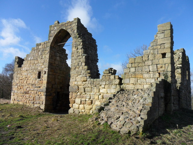
The wood has a rich history, with evidence of human habitation dating back centuries. It is said that the wood once provided timber for the construction of Durham Cathedral, a UNESCO World Heritage Site. Today, remnants of old stone walls and the occasional ruins of former buildings can be found within the wood, adding to its charm and intrigue.

Damhead Wood is a haven for nature lovers, offering a peaceful retreat from the surrounding urban environment. Whether it's a leisurely stroll, birdwatching, or simply enjoying the tranquility of nature, this woodland is a must-visit destination for anyone seeking solace within Durham's natural beauty.

If you have any feedback on the listing, please let us know in the comments section below.
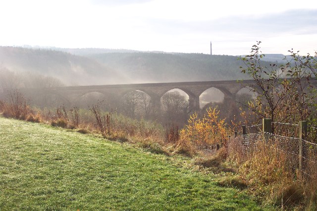
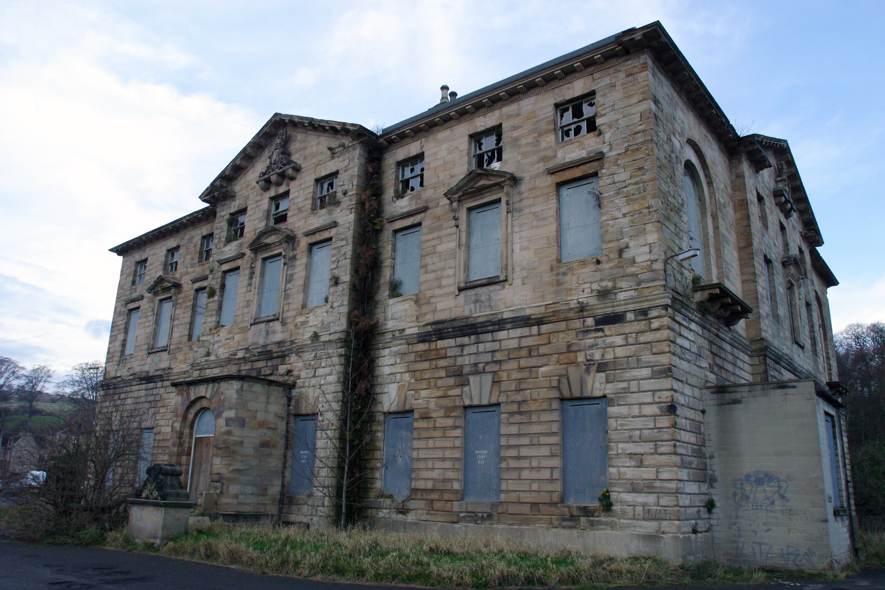
Damhead Wood Images

Images are sourced within 2km of 54.94512/-1.7019096 or Grid Reference NZ1961. Thanks to Geograph Open Source API. All images are credited.

Looking south to Nine Arches Viaduct from Goodshieldhaugh Hill Part of the Derwent Country Park. A not-so-little gem!
Looking south to Nine Arches Viaduct from Goodshieldhaugh Hill
Part of the Derwent Country Park. A not-so-little gem!
Viaduct Over the River Derwent Supposedly nine arches although only five in view here. Now carrying the Derwent Walk footpath and cycleway.
Viaduct Over the River Derwent
Supposedly nine arches although only five in view here. Now carrying the Derwent Walk footpath and cycleway.
Old Hollinside Old Hollinside is a 13thC hall block, 16m x 7m over walls a metre thick. It is positioned so that the 4m square latrine turret at the NW corner over hangs a steep drop to the river Derwent. Hollinside was occupied by the Harding family from the early 16thC to the early 18thC, when it was abandoned.
Old Hollinside
Old Hollinside is a 13thC hall block, 16m x 7m over walls a metre thick. It is positioned so that the 4m square latrine turret at the NW corner over hangs a steep drop to the river Derwent. Hollinside was occupied by the Harding family from the early 16thC to the early 18thC, when it was abandoned.
Rock art on sofa, June 2007 Wow, I thought, that looks just like prehistoric rock art lying on an old sofa outside Hollinside Farm. So I photographed it and sent it to the experts. They agreed, and the "sofa stone" as it was known has been logged and recorded and can now be seen at <span class="nowrap"><a title="http://archaeologydataservice.ac.uk/era/section/panel/overview.jsf?eraId=578" rel="nofollow ugc noopener" href="http://archaeologydataservice.ac.uk/era/section/panel/overview.jsf?eraId=578">Link</a><img style="margin-left:2px;" alt="External link" title="External link - shift click to open in new window" src="https://s1.geograph.org.uk/img/external.png" width="10" height="10"/></span>
Rock art on sofa, June 2007
Wow, I thought, that looks just like prehistoric rock art lying on an old sofa outside Hollinside Farm. So I photographed it and sent it to the experts. They agreed, and the "sofa stone" as it was known has been logged and recorded and can now be seen at LinkExternal link
Derwent Walk Country Park The Derwent Walk Country Park is a mixture of woodlands, meadows, wetlands, riverside and reclaimed industrial sites all linked by the Derwent Walk. The Derwent Walk is the track-bed of the old Derwent Valley Railway. It is 11 miles long and follows the Derwent Valley between Swalwell and Consett.
 
Derwenthaugh Park is a reclaimed area that was (up to 1986) the site of the former Derwenthaugh Coke Works. The two parks are now managed as one and there is no boundary between them.

<span class="nowrap"><a title="http://www.gateshead.gov.uk/Leisure%20and%20Culture/countryside/sites/derwent.aspx#1107" rel="nofollow ugc noopener" href="http://www.gateshead.gov.uk/Leisure%20and%20Culture/countryside/sites/derwent.aspx#1107">Link</a><img style="margin-left:2px;" alt="External link" title="External link - shift click to open in new window" src="https://s1.geograph.org.uk/img/external.png" width="10" height="10"/></span> – Gateshead Council
Derwent Walk Country Park
The Derwent Walk Country Park is a mixture of woodlands, meadows, wetlands, riverside and reclaimed industrial sites all linked by the Derwent Walk. The Derwent Walk is the track-bed of the old Derwent Valley Railway. It is 11 miles long and follows the Derwent Valley between Swalwell and Consett. Derwenthaugh Park is a reclaimed area that was (up to 1986) the site of the former Derwenthaugh Coke Works. The two parks are now managed as one and there is no boundary between them. LinkExternal link – Gateshead Council
Derwent Walk, Nine Arches The track-bed of the old Derwent Valley Railway, crossing the "Nine Arches" viaduct.
Derwent Walk, Nine Arches
The track-bed of the old Derwent Valley Railway, crossing the "Nine Arches" viaduct.
View South from Nine Arches Viaduct The Derwent Walk Country Park is a mixture of woodlands, meadows, wetlands, riverside and reclaimed industrial sites all linked by the Derwent Walk. The Derwent Walk is the track-bed of the old Derwent Valley Railway. It is 11 miles long and follows the Derwent Valley between Swalwell and Consett.
 
Derwenthaugh Park is a reclaimed area that was (up to 1986) the site of the former Derwenthaugh Coke Works. The two parks are now managed as one and there is no boundary between them.

<span class="nowrap"><a title="http://www.gateshead.gov.uk/Leisure%20and%20Culture/countryside/sites/derwent.aspx#1107" rel="nofollow ugc noopener" href="http://www.gateshead.gov.uk/Leisure%20and%20Culture/countryside/sites/derwent.aspx#1107">Link</a><img style="margin-left:2px;" alt="External link" title="External link - shift click to open in new window" src="https://s1.geograph.org.uk/img/external.png" width="10" height="10"/></span> – Gateshead Council
View South from Nine Arches Viaduct
The Derwent Walk Country Park is a mixture of woodlands, meadows, wetlands, riverside and reclaimed industrial sites all linked by the Derwent Walk. The Derwent Walk is the track-bed of the old Derwent Valley Railway. It is 11 miles long and follows the Derwent Valley between Swalwell and Consett. Derwenthaugh Park is a reclaimed area that was (up to 1986) the site of the former Derwenthaugh Coke Works. The two parks are now managed as one and there is no boundary between them. LinkExternal link – Gateshead Council
River Derwent Looking down to the River Derwent from the Nine Arches Viaduct.
River Derwent
Looking down to the River Derwent from the Nine Arches Viaduct.
River Derwent at Owlet Hill Showing the woods on the far bank. There is a very nice riverside walk here and the river is very lively along this stretch.
River Derwent at Owlet Hill
Showing the woods on the far bank. There is a very nice riverside walk here and the river is very lively along this stretch.
River Derwent at Lockhaugh meadows Looking north along the riverside path with the Nine Arches Viaduct in the background.
River Derwent at Lockhaugh meadows
Looking north along the riverside path with the Nine Arches Viaduct in the background.
View west beside Hole Lane Hole Lane runs east from Fellside Road in Whickham to Sunnisdie. Long Hill to the left.
View west beside Hole Lane
Hole Lane runs east from Fellside Road in Whickham to Sunnisdie. Long Hill to the left.
Looking west from Fellside Road Fellside Road runs south from Whickham to Burnofield. There are fine views to the west across the Tyne valley into Northumberland.
Looking west from Fellside Road
Fellside Road runs south from Whickham to Burnofield. There are fine views to the west across the Tyne valley into Northumberland.
Dog walkers on the Derwent Walk The Derwent Walk is a multi-user path for walkers, cyclists and horse-riders which follows the line of the old railway between Consett and the Tyne at Swalwell. It forms part of National Cycle Network route 14 which pursues a zigzag course across county Durham from Darlington to Hartlepool, Durham, Consett and Swalwell. It offers cyclists following the C2C an alternative route to finish at the sea at Tynemouth.

Downstream from Rowland's Gill village the path enters a linear country park known as Derwent Walk Country Park and Derwenthaugh Country Park. In the distance is the bridge which carries the footpath to Far Pastures Ponds.
Dog walkers on the Derwent Walk
The Derwent Walk is a multi-user path for walkers, cyclists and horse-riders which follows the line of the old railway between Consett and the Tyne at Swalwell. It forms part of National Cycle Network route 14 which pursues a zigzag course across county Durham from Darlington to Hartlepool, Durham, Consett and Swalwell. It offers cyclists following the C2C an alternative route to finish at the sea at Tynemouth. Downstream from Rowland's Gill village the path enters a linear country park known as Derwent Walk Country Park and Derwenthaugh Country Park. In the distance is the bridge which carries the footpath to Far Pastures Ponds.
River Derwent from Nine Arches Viaduct Looking upstream from the Nine Arches Viaduct on the Derwent Walk which follows the old railway from Swalwell to Consett. The construction of the massive 150 metre long viaduct was necessitated by the refusal of the Earl of Strathmore to let the railway pass through the Gibside Estate.
River Derwent from Nine Arches Viaduct
Looking upstream from the Nine Arches Viaduct on the Derwent Walk which follows the old railway from Swalwell to Consett. The construction of the massive 150 metre long viaduct was necessitated by the refusal of the Earl of Strathmore to let the railway pass through the Gibside Estate.
Nine Arches Viaduct on the Derwent Walk The Derwent Walk is a multi-user path for walkers, cyclists and horse-riders which follows the line of the old railway between Consett and the Tyne at Swalwell. It forms part of National Cycle Network route 14 which pursues a zigzag course across county Durham from Darlington to Hartlepool, Durham, Consett and Swalwell. It offers cyclists following the C2C an alternative route to finish at the sea at Tynemouth.

Downstream from Rowland's Gill village the path enters a linear country park known as Derwent Walk Country Park and Derwenthaugh Country Park. Here it crosses the 150 metre long Nine Arches Viaduct, the construction of which was necessitated by the refusal of the Earl of Strathmore to let the railway pass through the Gibside Estate.
Nine Arches Viaduct on the Derwent Walk
The Derwent Walk is a multi-user path for walkers, cyclists and horse-riders which follows the line of the old railway between Consett and the Tyne at Swalwell. It forms part of National Cycle Network route 14 which pursues a zigzag course across county Durham from Darlington to Hartlepool, Durham, Consett and Swalwell. It offers cyclists following the C2C an alternative route to finish at the sea at Tynemouth. Downstream from Rowland's Gill village the path enters a linear country park known as Derwent Walk Country Park and Derwenthaugh Country Park. Here it crosses the 150 metre long Nine Arches Viaduct, the construction of which was necessitated by the refusal of the Earl of Strathmore to let the railway pass through the Gibside Estate.
Derwent Walk Country Park These objects might possibly be an item of public artwork near the Nine Arches Viaduct in the linear Derwent Walk Country Park in Gateshead.
Derwent Walk Country Park
These objects might possibly be an item of public artwork near the Nine Arches Viaduct in the linear Derwent Walk Country Park in Gateshead.
Old wagonway bridge, Gibside This stone bridge is over Snipes Burn at the bottom of Snipes Dene on the Gibside Estate, a National Trust Property. <span class="nowrap"><a title="http://www.nationaltrust.org.uk/gibside/" rel="nofollow ugc noopener" href="http://www.nationaltrust.org.uk/gibside/">Link</a><img style="margin-left:2px;" alt="External link" title="External link - shift click to open in new window" src="https://s1.geograph.org.uk/img/external.png" width="10" height="10"/></span>
The burn runs down into the River Derwent, just out of shot on the right.
Old wagonway bridge, Gibside
This stone bridge is over Snipes Burn at the bottom of Snipes Dene on the Gibside Estate, a National Trust Property. LinkExternal link The burn runs down into the River Derwent, just out of shot on the right.
Hollinside Manor A 13th century manor house was home of the Harding family for two centuries. The estate passed on to George Bowes of Gibside in 1730 for the sum of £10,000.
Hollinside Manor
A 13th century manor house was home of the Harding family for two centuries. The estate passed on to George Bowes of Gibside in 1730 for the sum of £10,000.
Show me another place!

Damhead Wood is located at Grid Ref: NZ1961 (Lat: 54.94512, Lng: -1.7019096)

Unitary Authority: Gateshead

Police Authority: Northumbria

What 3 Words

///codes.cape.fits. Near Whickham, Tyne & Wear

Nearby Locations

Dam Head Damhead Wood

Related Wikis

Derwenthaugh Coke Works

Derwenthaugh Coke Works was a coking plant on the River Derwent near Swalwell in Gateshead. The works were built in 1928 on the site of the Crowley's Iron...

Winlaton Mill

Winlaton Mill is a village in Tyne and Wear, North East England. It is not to be confused with Winlaton to the northwest which now comprises the southern...

Axwell House

Axwell House (also Axwell Hall or Axwell Park) is a mansion house and Grade II* listed building, at Axwell Park, Blaydon, Tyne and Wear, England.The house...

Blaydon (UK Parliament constituency)

Blaydon is a constituency represented in the House of Commons since 2017 by Liz Twist of the Labour Party.The seat is due to be abolished for the next...

Nearby Amenities

Located within 500m of 54.94512,-1.7019096
Bus Stop
Derwenthaugh
Bench: no
Bin: no
Bus: yes
Local Ref: S
Naptan AtcoCode: 410000013925
Naptan Bearing: SW
Naptan Indicator: SW-Bound
Naptan Landmark: Opposite Spa Well Turn
Naptan NaptanCode: twrawgpd
Naptan PlusbusZoneRef: NWCSTLE
Naptan Street: Spa Well Road
Naptan Verified: no
Public Transport: platform
Shelter: no
Source: naptan_import
Lat/Long: 54.9469769/-1.7042951
Bus Stop
Spa Well Road
Bench: no
Bus: yes
Departures Board: timetable
Local Ref: S
Naptan AtcoCode: 410000013030
Naptan Bearing: SW
Naptan Indicator: SW-Bound
Naptan Landmark: Opposite Entrance To Axwell Park Hall
Naptan NaptanCode: twratwaw
Naptan PlusbusZoneRef: NWCSTLE
Naptan Street: Spa Well Road
Naptan Verified: no
Public Transport: platform
Shelter: no
Source: naptan_import
Lat/Long: 54.9491/-1.7017462
Bus Stop
Derwenthaugh
Bus: yes
Departures Board: timetable
Local Ref: N
Naptan AtcoCode: 410000013033
Naptan Bearing: NE
Naptan Indicator: NE-Bound
Naptan Landmark: Outside Spa Well Turn
Naptan NaptanCode: twratwdj
Naptan PlusbusZoneRef: NWCSTLE
Naptan Street: Spa Well Road
Naptan Verified: no
Public Transport: platform
Shelter: yes
Source: naptan_import
Lat/Long: 54.9476577/-1.7035679
Power: tower
Lat/Long: 54.9458066/-1.7057137
Power: tower
Lat/Long: 54.9466423/-1.701522
Power: tower
Lat/Long: 54.9470186/-1.6989742
Power: tower
Lat/Long: 54.9438973/-1.6961861
Power: tower
Lat/Long: 54.9419934/-1.6996953
Barrier: cycle_barrier
Bicycle: yes
Foot: designated
Horse: no
Motor Vehicle: no
Lat/Long: 54.9490252/-1.6993775
Power: tower
Lat/Long: 54.9412784/-1.7006424
Power: tower
Lat/Long: 54.9426374/-1.6985083
Power: tower
Lat/Long: 54.9432744/-1.6973343
Power: tower
Lat/Long: 54.9445496/-1.6950145
Power: tower
Lat/Long: 54.9460322/-1.7083559
Power: tower
Lat/Long: 54.9460873/-1.7043057
Power: tower
Lat/Long: 54.9463606/-1.7029349
Power: tower
Lat/Long: 54.9467993/-1.7004589
Power: tower
Lat/Long: 54.9469257/-1.6996029
Power: tower
Lat/Long: 54.9475886/-1.6975969
Power: tower
Lat/Long: 54.948147/-1.6962475
Cafe
Lat/Long: 54.9472323/-1.7028513
Pub
Lat/Long: 54.9470998/-1.7027602
Enclosures near Damhead wood
HE Ref: 1005913
Archaeological Site: settlement
Designation: scheduled_monument
Historic: archaeological_site
Wikidata: Q17640707
Lat/Long: 54.9440766/-1.7008853
The data included in this document is from www.openstreetmap.org. The data is made available under ODbL.

Have you been to Damhead Wood?

Leave your review of Damhead Wood below (or comments, questions and feedback).