Birchinlee East Plantation

Wood, Forest in Derbyshire High Peak

England

Birchinlee East Plantation

Path by the road There are worse paths. You don't have to walk on the road and the forest does allow views over the reservoir. On a baking hot day, the trees provide welcome shade.
Path by the road Credit: Bill Boaden

Birchinlee East Plantation is a woodland area located in Derbyshire, England. Situated near the village of Birchinlee, the plantation is part of the larger Peak District National Park. Covering an area of approximately 100 acres, it is a popular destination for outdoor enthusiasts, nature lovers, and hikers.

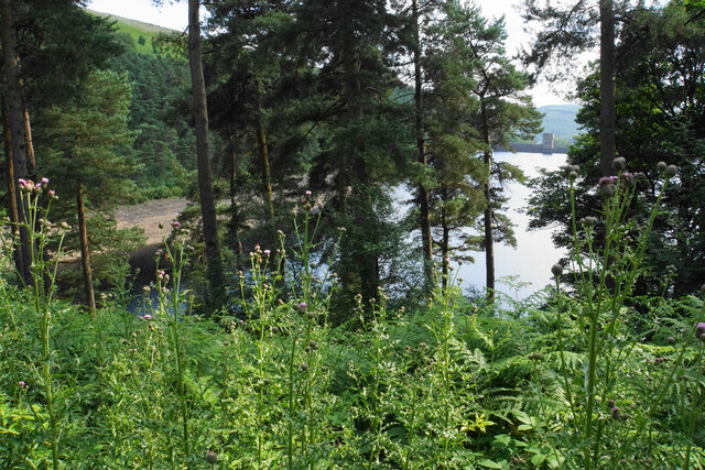
The woodland is predominantly composed of deciduous trees, including oak, birch, and beech, which create a vibrant and diverse ecosystem. The canopy formed by these trees provides shade and shelter for a variety of wildlife species, such as deer, foxes, badgers, and a wide range of bird species.

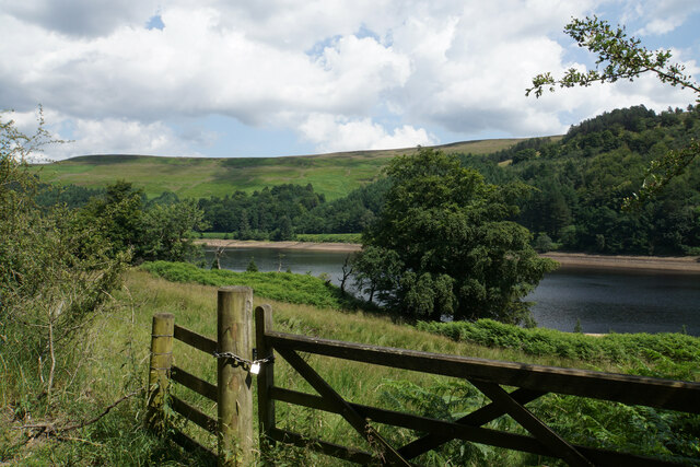
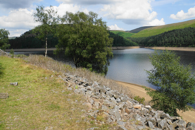
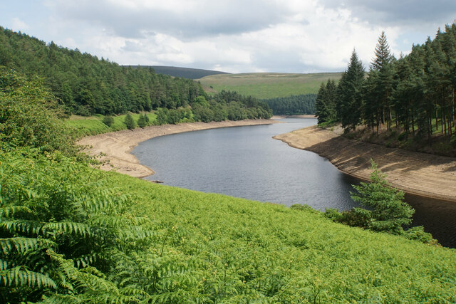
The plantation is crisscrossed by a network of well-maintained footpaths, allowing visitors to explore the area and enjoy its natural beauty. One of the main attractions within the woodland is the Birchinlee East Reservoir, a man-made lake that was created in the 19th century to supply water to the nearby city of Sheffield. The reservoir, surrounded by trees and offering breathtaking views, is a popular spot for picnicking, fishing, and birdwatching.

Birchinlee East Plantation also holds historical significance as it was once part of a larger industrial landscape. In the past, the area was home to lead mines and quarries, which played a crucial role in the local economy. Today, remnants of this industrial heritage can still be found within the woodland, adding an extra layer of interest for history enthusiasts.

Overall, Birchinlee East Plantation offers a peaceful and picturesque setting, where visitors can immerse themselves in nature, explore the area's history, and enjoy outdoor activities in a tranquil environment.

If you have any feedback on the listing, please let us know in the comments section below.

Birchinlee East Plantation Images

Images are sourced within 2km of 53.423246/-1.7491265 or Grid Reference SK1691. Thanks to Geograph Open Source API. All images are credited.

Path by the road There are worse paths. You don't have to walk on the road and the forest does allow views over the reservoir. On a baking hot day, the trees provide welcome shade.
Path by the road
There are worse paths. You don't have to walk on the road and the forest does allow views over the reservoir. On a baking hot day, the trees provide welcome shade.
Land above Upper Derwent Reservoir Mostly scrub, and there is not much you can do with it.
Land above Upper Derwent Reservoir
Mostly scrub, and there is not much you can do with it.
Gores Farm A rare habitation in this valley. There isn't much scope for farming any more.
Gores Farm
A rare habitation in this valley. There isn't much scope for farming any more.
Inlet on Upper Derwent Reservoir Originally the lower end of Ouzelden Clough.
Inlet on Upper Derwent Reservoir
Originally the lower end of Ouzelden Clough.
Woodland track towards Ouzelden Clough Not a formal footpath but this is access land.
Woodland track towards Ouzelden Clough
Not a formal footpath but this is access land.
Upper Derwent Reservoir I think the stone blocks in the water may be former footings of a railway bridge across Ouzelden Brook.
Upper Derwent Reservoir
I think the stone blocks in the water may be former footings of a railway bridge across Ouzelden Brook.
Path through Birchinlee East Plantation The nettles and mounds suggest former habitation, and this was probably part of the former village of Birchinlee.
Path through Birchinlee East Plantation
The nettles and mounds suggest former habitation, and this was probably part of the former village of Birchinlee.
Howden Reservoir The bank has been built up here, probably to support the road just above. Howden Clough is opposite.
Howden Reservoir
The bank has been built up here, probably to support the road just above. Howden Clough is opposite.
Howden Dam The highest of the three dams in the upper Derwent valley.
Howden Dam
The highest of the three dams in the upper Derwent valley.
Howden Reservoir This would have been the confluence of the rivers Westend and Derwent.
Howden Reservoir
This would have been the confluence of the rivers Westend and Derwent.
Howden Reservoir An arm of the reservoir which used to be the valley of the River Westend. Ridge Clough flows into it opposite.
Howden Reservoir
An arm of the reservoir which used to be the valley of the River Westend. Ridge Clough flows into it opposite.
Road below Hern Side The road and path are traversing Howden Reservoir on the right.
Road below Hern Side
The road and path are traversing Howden Reservoir on the right.
The head of an arm of Howden Reservoir The course of the River Westend, but when the water is not at summer low levels, this is part of the reservoir.
The head of an arm of Howden Reservoir
The course of the River Westend, but when the water is not at summer low levels, this is part of the reservoir.
Ditch Brook Meandering through Ditch Clough Plantation shortly before meeting the River Westend.
Ditch Brook
Meandering through Ditch Clough Plantation shortly before meeting the River Westend.
Ditch Clough The bottom of the clough in Ditch Clough Plantation.
Ditch Clough
The bottom of the clough in Ditch Clough Plantation.
Fern bank overlooking Howden Reservoir A view from the road which runs along most of the western side of the reservoir. This part of the reservoir used to be the valley of the River Westend.
Fern bank overlooking Howden Reservoir
A view from the road which runs along most of the western side of the reservoir. This part of the reservoir used to be the valley of the River Westend.
The bottom of Ridge Clough Joining Howden Reservoir.
The bottom of Ridge Clough
Joining Howden Reservoir.
Foliage above Howden Reservoir There are rare glimpses of the reservoir through the leaves from the main track, but this one gives a brief view of Howden Dam.
Foliage above Howden Reservoir
There are rare glimpses of the reservoir through the leaves from the main track, but this one gives a brief view of Howden Dam.
Show me another place!

Birchinlee East Plantation is located at Grid Ref: SK1691 (Lat: 53.423246, Lng: -1.7491265)

Administrative County: Derbyshire

District: High Peak

Police Authority: Derbyshire

What 3 Words

///flush.pull.hardback. Near Hope Valley, Derbyshire

Related Wikis

Nearby Amenities

Located within 500m of 53.423246,-1.7491265
Birchinlee Village
Source: gps
Tourism: information
Lat/Long: 53.4226641/-1.7496743
Bank Clough
Place: locality
Lat/Long: 53.4241064/-1.7533865
Birchinlee
Place: isolated_dwelling
Lat/Long: 53.4213921/-1.7536712
Abbey Grange
Historic Place: isolated_dwelling
Lat/Long: 53.4241591/-1.743882
Birchinlee Farm
Historic Place: farm
Lat/Long: 53.422952/-1.7508574
Tin Town
Board Type: history
Description: The Married Quarters
Information: board
Tourism: information
Lat/Long: 53.4189911/-1.7512035
Tin Town
Board Type: history
Description: Village Life
Information: board
Tourism: information
Lat/Long: 53.4200781/-1.7516997
Tin Town
Board Type: history
Description: Life Indoors
Information: board
Tourism: information
Lat/Long: 53.4210076/-1.7510399
Tin Town
Information: board
Tourism: information
Lat/Long: 53.4223734/-1.7503895
Bench
Lat/Long: 53.4224652/-1.7457057
Information: guidepost
Operator: Peak & Northern Footpaths Society
Ref: 72
Source: survey;gps
Tourism: information
Lat/Long: 53.4239219/-1.7445959
The data included in this document is from www.openstreetmap.org. The data is made available under ODbL.

Have you been to Birchinlee East Plantation?

Leave your review of Birchinlee East Plantation below (or comments, questions and feedback).