Keepence Copse

Wood, Forest in Wiltshire

England

Keepence Copse

Foxbury Copse, West Woods Bluebells and a track within Foxbury Copse (part of West Woods).
Foxbury Copse, West Woods Credit: Rebecca A Wills

Keepence Copse is a beautiful woodland located in the county of Wiltshire, England. Covering an area of approximately 100 acres, it is a popular destination for nature lovers, hikers, and wildlife enthusiasts. The copse is situated near the village of Keepence, which lies within the stunning Wiltshire countryside.

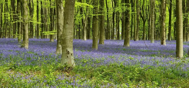
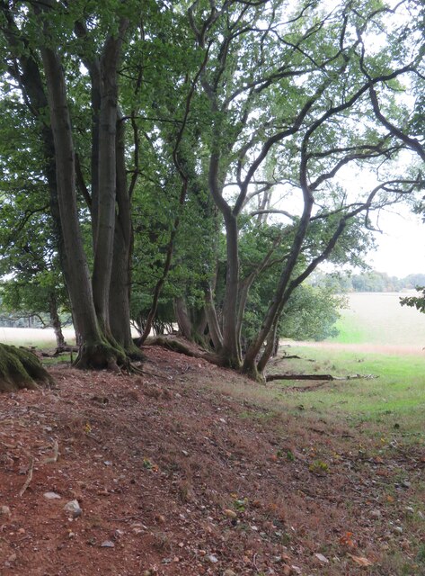
This ancient woodland is predominantly comprised of native broadleaf trees such as oak, beech, and ash, creating a rich and diverse ecosystem. The dense canopy of these towering trees provides a haven for a wide range of bird species, including woodpeckers, owls, and various songbirds. Additionally, the woodland floor is adorned with a plethora of wildflowers, ferns, and mosses, enhancing the enchanting atmosphere.

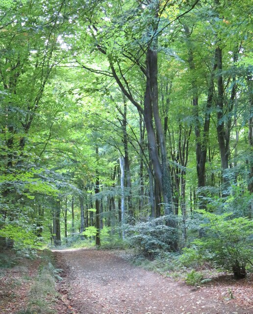
Several well-maintained footpaths wind their way through the copse, allowing visitors to explore its natural wonders. These paths provide an opportunity to discover hidden glades, babbling brooks, and even the occasional ancient monument or archaeological site. The copse is also home to a variety of mammals, including deer, foxes, and badgers, which can often be spotted during dawn or dusk.

Keepence Copse offers a peaceful and tranquil escape from the hustle and bustle of everyday life. It is a place where visitors can immerse themselves in the beauty of nature, breathe in the fresh woodland air, and enjoy the sights and sounds of the countryside. Whether it's a leisurely stroll, a picnic with family and friends, or simply a moment of quiet contemplation, Keepence Copse is a hidden gem waiting to be explored.

If you have any feedback on the listing, please let us know in the comments section below.

Keepence Copse Images

Images are sourced within 2km of 51.391823/-1.769249 or Grid Reference SU1665. Thanks to Geograph Open Source API. All images are credited.

Foxbury Copse, West Woods Bluebells and a track within Foxbury Copse (part of West Woods).
Foxbury Copse, West Woods
Bluebells and a track within Foxbury Copse (part of West Woods).
Wools Grove, West Woods Bluebells in Wools Grove, within West Woods.
Wools Grove, West Woods
Bluebells in Wools Grove, within West Woods.
Access track to West Woods car park Woodland managed by Forestry England.
Access track to West Woods car park
Woodland managed by Forestry England.
Shady picnic tables at West Woods car park
Parking area on the edge of West Woods Not signposted on any road out of Lockeridge, and presumably used mostly by local dog walkers.
Parking area on the edge of West Woods
Not signposted on any road out of Lockeridge, and presumably used mostly by local dog walkers.
Dappled sunlight, West Woods West Woods are a large area of ancient woodland which at one time may have been joined to Savernake Forest. This might be ancient woodland recorded for 400 years or so, but one would have to search long and hard for any really ancient trees.
Dappled sunlight, West Woods
West Woods are a large area of ancient woodland which at one time may have been joined to Savernake Forest. This might be ancient woodland recorded for 400 years or so, but one would have to search long and hard for any really ancient trees.
Track in West Woods This track is shown as a 'BOAT' on OS maps and is also the course of the Wansdyke Path. The Wansdyke is off picture to the left and is quite insignificant at this point.
Track in West Woods
This track is shown as a 'BOAT' on OS maps and is also the course of the Wansdyke Path. The Wansdyke is off picture to the left and is quite insignificant at this point.
Slight remains of Wansdyke The low mount surmounted by trees marks the Wansdyke bank, but the ditch to the right has largely disappeared thanks to some 1500 years of slow infill.
The Wansdyke still has an air of mystery. Who built it and why?  It appears to be post Roman in date as at one point it crosses a Roman Road, whilst the ditch is on the north side, which suggests that if it was a defensive line, then it was defending land to the south.
Slight remains of Wansdyke
The low mount surmounted by trees marks the Wansdyke bank, but the ditch to the right has largely disappeared thanks to some 1500 years of slow infill. The Wansdyke still has an air of mystery. Who built it and why? It appears to be post Roman in date as at one point it crosses a Roman Road, whilst the ditch is on the north side, which suggests that if it was a defensive line, then it was defending land to the south.
Path towards West Woods Bridleway which is probably part of an old route from Huish to Lockeridge and is now part of the White Horse Trail.
Path towards West Woods
Bridleway which is probably part of an old route from Huish to Lockeridge and is now part of the White Horse Trail.
Clearing in Hursley Bottom A clearing in West Woods, complete with picnic table.
Clearing in Hursley Bottom
A clearing in West Woods, complete with picnic table.
Path junction near Huish Hill House Farm access tracks and alternative paths. A footpath leads off to the right whilst a bridleway, which is part of the Tan Hill way goes ahead and to the left.
Path junction near Huish Hill House
Farm access tracks and alternative paths. A footpath leads off to the right whilst a bridleway, which is part of the Tan Hill way goes ahead and to the left.
Farmland and woodland Looking north from near the top of Oare Hill across recently tilled arable land towards West Woods. On the distant skyline can be seen the beech clumps on Hackpen Hill.
Farmland and woodland
Looking north from near the top of Oare Hill across recently tilled arable land towards West Woods. On the distant skyline can be seen the beech clumps on Hackpen Hill.
Farmland, Savernake A strip of woodland seen end-on from the footpath near Levetts Farm.
Farmland, Savernake
A strip of woodland seen end-on from the footpath near Levetts Farm.
Farmland, Savernake A cereal crop to the south-west of Wernham Farm.
Farmland, Savernake
A cereal crop to the south-west of Wernham Farm.
Road junction where Manton Drove joins the A345
West Woods, Nr Lockeridge in May when the wood is carpeted with 'Bluebells'
Path through West Woods In May the woods burst into colour with bluebells on the ground and the delicate green of new leaves on the beech trees.
Path through West Woods
In May the woods burst into colour with bluebells on the ground and the delicate green of new leaves on the beech trees.
Clatford Bottom The northern half of the valley which is mostly agricultural. The southern half is largely wooded. Cottages at Clatford are just visible.
Clatford Bottom
The northern half of the valley which is mostly agricultural. The southern half is largely wooded. Cottages at Clatford are just visible.
Show me another place!

Keepence Copse is located at Grid Ref: SU1665 (Lat: 51.391823, Lng: -1.769249)

Unitary Authority: Wiltshire

Police Authority: Wiltshire

What 3 Words

///narrow.energetic.comedy. Near Huish, Wiltshire

Related Wikis

Lockeridge

Lockeridge is a village in Wiltshire, England. It lies at the edge of the West Woods in the Kennet Valley, 2.9 miles (4.7 km) west of Marlborough, 3.1...

Clatford

Clatford is a small hamlet (formerly a village) approximately 1 mile (1.6 km) west of the village of Manton and about 2 miles (3.2 km) west of Marlborough...

Martinsell Hill

Martinsell Hill, near Oare and north of Pewsey, is the third highest point in the county of Wiltshire, southwest England, at some 289 m / 948 ft above...

Manton, Wiltshire

Manton is a small village in Wiltshire, England, on the western outskirts of Marlborough just off the A4 Bath Road. == History == A settlement of twelve...

Huish, Wiltshire

Huish is a small village and former civil parish, now in the parish of Wilcot, Huish and Oare, in Wiltshire, England, 2 miles (3.2 km) northwest of Pewsey...

Oare House

Oare House is a Grade I listed country house in Oare, Wiltshire, England.The house was built in 1740 for a London wine merchant, Henry Deacon. It was largely...

Oare Pavilion

The Oare Pavilion or Oare Tea House Pavilion is a summer house designed by I. M. Pei for the businessman Henry Keswick and his wife Tessa Keswick at Oare...

Oare, Wiltshire

Oare is a small village in the east of the county of Wiltshire, England. The village lies about 2 miles (3.2 km) north of Pewsey, on the A345 road towards...

Nearby Amenities

Located within 500m of 51.391823,-1.769249
Eastside Cottage
Place: isolated_dwelling
Wikidata: Q26573389
Lat/Long: 51.3909749/-1.7643365
West Woods
Place: isolated_dwelling
Lat/Long: 51.3900177/-1.7644819
Power: pole
Source: Bing
Lat/Long: 51.3928063/-1.7639604
Power: pole
Source: Bing
Lat/Long: 51.3920933/-1.7634561
Power: pole
Source: Bing
Lat/Long: 51.3906506/-1.7624261
Power: pole
Source: Bing
Lat/Long: 51.3899813/-1.7718943
Power: pole
Source: Bing
Lat/Long: 51.3906305/-1.7633488
Bench
Lat/Long: 51.396112/-1.7712714
Power: pole
Source: Bing
Lat/Long: 51.3913701/-1.7629195
Power: pole
Source: Bing
Lat/Long: 51.3936028/-1.7645717
Broadleat
Natural: wood
Lat/Long: 51.3942792/-1.7733445
Pig-trough Copse
Natural: wood
Lat/Long: 51.3904715/-1.7738896
Stone's Wood
Natural: wood
Lat/Long: 51.3898879/-1.7673228
The data included in this document is from www.openstreetmap.org. The data is made available under ODbL.

Have you been to Keepence Copse?

Leave your review of Keepence Copse below (or comments, questions and feedback).