Arkleby

Settlement in Cumberland Allerdale

England

Arkleby

B5301 near Arkleby Mill
B5301 near Arkleby Mill Credit: Colin Pyle

Arkleby is a small village located in the county of Cumberland, in the northwestern part of England. Nestled amidst picturesque countryside, it is situated about 5 miles west of the town of Wigton. With a population of around 300 residents, Arkleby exudes a peaceful and rural charm.

The village itself is characterized by a collection of traditional stone houses, many of which date back several centuries. The architecture reflects the area's rich history and gives the village a timeless appeal. The surrounding landscape is dominated by rolling hills, lush meadows, and dense woodlands, making it an ideal destination for nature lovers and hikers.

Although small, Arkleby boasts a strong sense of community. The village has a primary school, a village hall, and a local pub, which serves as a social hub for residents and visitors alike. The pub often hosts events and gatherings, fostering a friendly and welcoming atmosphere.

The village is well-positioned for those seeking both tranquility and access to amenities. The nearby town of Wigton provides a range of services including shops, supermarkets, and healthcare facilities. Additionally, the city of Carlisle is just a short drive away, offering further amenities and transport connections.

Arkleby's idyllic location makes it a popular destination for outdoor enthusiasts. There are numerous walking and cycling trails in the vicinity, allowing visitors to explore the stunning countryside. The village also benefits from its proximity to the Lake District National Park, renowned for its breathtaking scenery and outdoor recreational opportunities.

In summary, Arkleby is a charming village set amidst the natural beauty of Cumberland. With its rich history, close-knit community, and access to stunning landscapes, it provides a peaceful and picturesque retreat for residents and visitors alike.

If you have any feedback on the listing, please let us know in the comments section below.
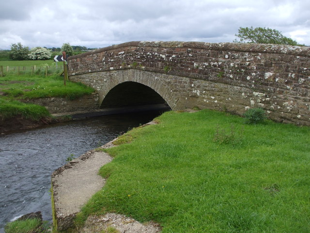
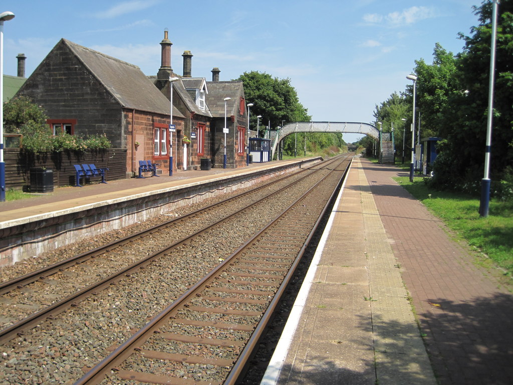
Arkleby Images

Images are sourced within 2km of 54.745377/-3.334405 or Grid Reference NY1439. Thanks to Geograph Open Source API. All images are credited.

B5301 near Arkleby Mill
Aspataria Station, looking to Carlisle
Road to Prospect Woodland at Hew Rigg
Road to Prospect
Woodland at Hew Rigg
Railway bridge Sheep by railway bridge near Ellen Villa
Railway bridge
Sheep by railway bridge near Ellen Villa
Benchmark on gatepost at gateway on south side of A596 west of Aspatria Ordnance Survey cut mark benchmark levelled at 85.803m above Newlyn Datum verified 1970
Benchmark on gatepost at gateway on south side of A596 west of Aspatria
Ordnance Survey cut mark benchmark levelled at 85.803m above Newlyn Datum verified 1970
Gateway to field on south side A596 opposite Castlemont There is an Ordnance Survey benchmark <a href="https://www.geograph.org.uk/photo/7648426">NY1341 : Benchmark on gatepost at gateway on south side of A596 west of Aspatria</a> on the inside face of the stone gatepost at the far side of the gateway
Gateway to field on south side A596 opposite Castlemont
There is an Ordnance Survey benchmark NY1341 : Benchmark on gatepost at gateway on south side of A596 west of Aspatria on the inside face of the stone gatepost at the far side of the gateway
Entrance to Castlemont from north side of A596
Town welcome sign at west end of town
Milk churns on flower box on south side of West Street
Benchmark on building (former surgery) on SE side of West Street Ordnance Survey cut mark benchmark levelled at 78.861m above Newlyn Datum verified 1970
Benchmark on building (former surgery) on SE side of West Street
Ordnance Survey cut mark benchmark levelled at 78.861m above Newlyn Datum verified 1970
Former surgery on SE side of West Street There is an Ordnance Survey benchmark <a href="https://www.geograph.org.uk/photo/7650669">NY1441 : Benchmark on building (former surgery) on SE side of West Street</a> on the near corner, road face, of the building
Former surgery on SE side of West Street
There is an Ordnance Survey benchmark NY1441 : Benchmark on building (former surgery) on SE side of West Street on the near corner, road face, of the building
The Red Lion pub on south side of West Street
Road junction at West Fitz There is a Cumbria finger signpost on the left hand verge
Road junction at West Fitz
There is a Cumbria finger signpost on the left hand verge
Two T-junctions on road towards West Fitz with finger signposts The nearer signpost <a href="https://www.geograph.org.uk/photo/7653163">NY1540 : Cumberland County Council finger signpost at T-junction west of Fitz</a>  is of Cumberland County Council provenance, the one in the distance <a href="https://www.geograph.org.uk/photo/7653153">NY1540 : Road junction at West Fitz</a>  from Cumbria
Two T-junctions on road towards West Fitz with finger signposts
The nearer signpost NY1540 : Cumberland County Council finger signpost at T-junction west of Fitz is of Cumberland County Council provenance, the one in the distance NY1540 : Road junction at West Fitz from Cumbria
River Ellen in flood
Aspatria railway station, Cumbria Opened in 1841 by the Maryport & Carlisle Railway on what is today the line from Barrow-in-Furness to Carlisle. View north east towards Brayton and Carlisle.
Aspatria railway station, Cumbria
Opened in 1841 by the Maryport & Carlisle Railway on what is today the line from Barrow-in-Furness to Carlisle. View north east towards Brayton and Carlisle.
Arkleby Bridge over the River Ellen Single span late 19thC rubble bridge.
Arkleby Bridge over the River Ellen
Single span late 19thC rubble bridge.
Aspatria railway station, from the footbridge The station is now an unstaffed halt. The only public 'buildings' are the blue and white shelters on each platform.
Aspatria railway station, from the footbridge
The station is now an unstaffed halt. The only public 'buildings' are the blue and white shelters on each platform.
Show me another place!

Arkleby is located at Grid Ref: NY1439 (Lat: 54.745377, Lng: -3.334405)

Administrative County: Cumbria

District: Allerdale

Police Authority: Cumbria

What 3 Words

///mooring.nerd.umbrellas. Near Aspatria, Cumbria

Nearby Locations

Arkleby

Related Wikis

Parsonby

Parsonby is a hamlet in the English county of Cumbria. It is located on the B5301 road, south of Aspatria. == Governance == Parsonby, is part of the Workington...

Plumbland

Plumbland is a village and civil parish in the county of Cumbria, England. Situated towards the north west corner of the county, it is two miles from the...

Arkleby railway station

Arkleby railway station was an early railway station on the Maryport and Carlisle Railway, in north-west England, close to the village of Arkleby in Cumbria...

Aspatria railway station

Aspatria railway station is a railway station serving the town of Aspatria in Cumbria, England. It is on the Cumbrian Coast Line, which runs between Carlisle...

Threapland, Cumbria

Threapland is a hamlet in the civil parish of Bothel and Threapland, in the Cumberland district, in the ceremonial county of Cumbria, England. Nearby settlements...

Arkleby

Arkleby is a village in Cumbria, England. It is located about 1 mile south of Aspatria and 9 miles south-west of Wigton. Arkleby is part of the civil parish...

A596 road

The A596 is a primary route in Cumbria, in northern England, that runs between Thursby (5 miles (8.0 km) north-east of Wigton) and Workington. For its...

St. Kentigern's Church, Aspatria

St Kentigern's Church stands in the village of Aspatria, Cumbria, England. It is an active Anglican parish church in the rural deanery of Maryport, the...

Nearby Amenities

Located within 500m of 54.745377,-3.334405
Arkleby
Is In: Cumbria, England, UK
Place: hamlet
Source: npe
Wikidata: Q4792019
Wikipedia: en:Arkleby
Lat/Long: 54.7437034/-3.3350697
Gilcrux-Aspatria junction
Local Ref: AT
Naptan AtcoCode: 090002461341
Naptan Bearing: W
Naptan BusStopType: CUS
Naptan CommonName: Gilcrux-Aspatria junction
Naptan Indicator: at
Naptan Landmark: Gilcrux-Aspatria junction
Naptan NaptanCode: cumagjtg
Naptan Street: B5301
Naptan Verified: no
Source: naptan_import
Lat/Long: 54.7429599/-3.3330337
Toll Bar Cottage
Local Ref: AT
Naptan AtcoCode: 090002463796
Naptan Bearing: S
Naptan BusStopType: CUS
Naptan CommonName: Toll Bar Cottage
Naptan Indicator: at
Naptan Landmark: Gilgrux Aspatria junction
Naptan NaptanCode: cumagjwg
Naptan Street: B5301
Naptan Verified: no
Source: naptan_import
Lat/Long: 54.7430068/-3.3328489
Barrier: stile
Lat/Long: 54.7446539/-3.3317141
Barrier: cattle_grid
Lat/Long: 54.7426173/-3.3361779
Unsuitable For Motor Vehicles
Traffic Sign: yes
Lat/Long: 54.7454351/-3.3300523
Power: pole
Lat/Long: 54.7483021/-3.336564
Power: pole
Lat/Long: 54.7491646/-3.3357289
Power: pole
Lat/Long: 54.7437603/-3.3353176
Power: pole
Lat/Long: 54.7437615/-3.3342428
Power: pole
Lat/Long: 54.7437412/-3.3326823
Power: pole
Lat/Long: 54.7432115/-3.3316117
Power: pole
Lat/Long: 54.7423071/-3.3311445
Waste Basket
Lat/Long: 54.7412802/-3.3324123
The data included in this document is from www.openstreetmap.org. The data is made available under ODbL.

Have you been to Arkleby?

Leave your review of Arkleby below (or comments, questions and feedback).