Sheepshaw Plantation
Wood, Forest in Yorkshire Craven
England
Sheepshaw Plantation
Sheepshaw Plantation, located in Yorkshire, England, is a picturesque woodland area known for its natural beauty and rich history. Nestled within the rolling hills of Yorkshire, this plantation covers a vast area of land, showcasing a diverse range of flora and fauna.
The plantation is primarily composed of dense forests, with towering oak, beech, and ash trees dominating the landscape. These majestic trees provide a haven for various bird species, including woodpeckers and owls, making it a popular spot for birdwatching enthusiasts. The forest floor is adorned with a carpet of bluebells during the spring, creating a stunning display of colors.
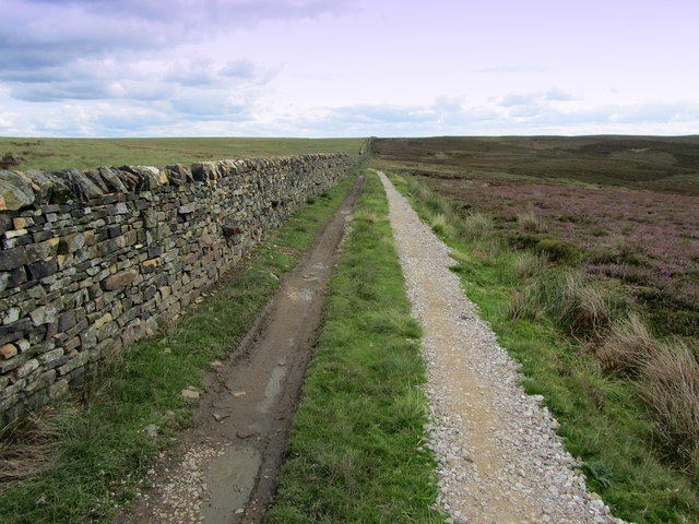
The plantation also boasts an extensive network of walking trails, allowing visitors to explore its charm at their own pace. These paths wind through the woodland, offering breathtaking views of the surrounding countryside and glimpses of wildlife along the way.
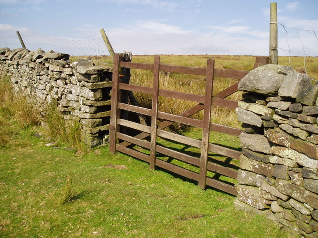
In addition to its natural beauty, Sheepshaw Plantation has a rich historical significance. It was once a thriving sheep farm during the medieval period, hence the name. Remnants of old stone walls and sheep pens can still be found, serving as a reminder of its agricultural past.
Today, Sheepshaw Plantation is managed by the Yorkshire Woodland Trust, a conservation organization dedicated to preserving and enhancing the natural environment. The trust organizes various educational programs and events to raise awareness about the importance of sustainable woodland management.
Overall, Sheepshaw Plantation in Yorkshire is a haven for nature lovers and history enthusiasts alike, offering a serene escape into the beauty of the English countryside.
If you have any feedback on the listing, please let us know in the comments section below.
Sheepshaw Plantation Images
Images are sourced within 2km of 54.010177/-1.8755125 or Grid Reference SE0857. Thanks to Geograph Open Source API. All images are credited.
![A circular walk along the River Wharfe [1] Leaving the Cavendish Pavilion, the track enters woodland.
Starting from the Cavendish Pavilion, the walk follows the west bank of the River Wharfe upstream, passing The Strid, to the Barden Aqueduct Bridge. Crossing to the east bank, the walk continues downstream to return to the starting point. Just over 3½ miles.](https://s1.geograph.org.uk/geophotos/07/01/89/7018925_66eb2f66.jpg)
![A circular walk along the River Wharfe [2] The river, seen from the path near the Sulphur Well.
Starting from the Cavendish Pavilion, the walk follows the west bank of the River Wharfe upstream, passing The Strid, to the Barden Aqueduct Bridge. Crossing to the east bank, the walk continues downstream to return to the starting point. Just over 3½ miles.](https://s2.geograph.org.uk/geophotos/07/01/89/7018930_cd410f5d.jpg)
![A circular walk along the River Wharfe [3] The river looking upstream, seen from the path.
Starting from the Cavendish Pavilion, the walk follows the west bank of the River Wharfe upstream, passing The Strid, to the Barden Aqueduct Bridge. Crossing to the east bank, the walk continues downstream to return to the starting point. Just over 3½ miles.](https://s1.geograph.org.uk/geophotos/07/01/89/7018933_c493bcd6.jpg)
![A circular walk along the River Wharfe [4] Away from the main track, this lower path is close to the river.
Starting from the Cavendish Pavilion, the walk follows the west bank of the River Wharfe upstream, passing The Strid, to the Barden Aqueduct Bridge. Crossing to the east bank, the walk continues downstream to return to the starting point. Just over 3½ miles.](https://s0.geograph.org.uk/geophotos/07/01/89/7018940_5ab0786e.jpg)
![A circular walk along the River Wharfe [5] The way returns to the main track from the lower path.
Starting from the Cavendish Pavilion, the walk follows the west bank of the River Wharfe upstream, passing The Strid, to the Barden Aqueduct Bridge. Crossing to the east bank, the walk continues downstream to return to the starting point. Just over 3½ miles.](https://s0.geograph.org.uk/geophotos/07/01/89/7018944_0a842b84.jpg)
![A circular walk along the River Wharfe [6] The path leads through woodland alongside the river.
Starting from the Cavendish Pavilion, the walk follows the west bank of the River Wharfe upstream, passing The Strid, to the Barden Aqueduct Bridge. Crossing to the east bank, the walk continues downstream to return to the starting point. Just over 3½ miles.](https://s0.geograph.org.uk/geophotos/07/01/89/7018948_5c3f5f3b.jpg)
![A circular walk along the River Wharfe [7] The river is very tranquil along this stretch.
Starting from the Cavendish Pavilion, the walk follows the west bank of the River Wharfe upstream, passing The Strid, to the Barden Aqueduct Bridge. Crossing to the east bank, the walk continues downstream to return to the starting point. Just over 3½ miles.](https://s2.geograph.org.uk/geophotos/07/01/89/7018950_75e15b2b.jpg)
![A circular walk along the River Wharfe [8] The track is now somewhat higher above the water.
Starting from the Cavendish Pavilion, the walk follows the west bank of the River Wharfe upstream, passing The Strid, to the Barden Aqueduct Bridge. Crossing to the east bank, the walk continues downstream to return to the starting point. Just over 3½ miles.](https://s0.geograph.org.uk/geophotos/07/01/97/7019700_9fb6a40e.jpg)
![A circular walk along the River Wharfe [9] The river makes a bend to the right.
Starting from the Cavendish Pavilion, the walk follows the west bank of the River Wharfe upstream, passing The Strid, to the Barden Aqueduct Bridge. Crossing to the east bank, the walk continues downstream to return to the starting point. Just over 3½ miles.](https://s1.geograph.org.uk/geophotos/07/01/97/7019701_64868ed9.jpg)
![A circular walk along the River Wharfe [10] The Strid is a 15 foot (4.6 m) deep underwater channel caused by the narrowing of the river from 90 ft (27 m) wide, just to the north, to the width of a long stride less than 300 ft (91 m) later. It is especially dangerous as both banks are undercut. Its name comes from the Old English Stryth, meaning 'turmoil'. This was later corrupted to Strid, referring to 'the possibility of striding across'.
Starting from the Cavendish Pavilion, the walk follows the west bank of the River Wharfe upstream, passing The Strid, to the Barden Aqueduct Bridge. Crossing to the east bank, the walk continues downstream to return to the starting point. Just over 3½ miles.](https://s2.geograph.org.uk/geophotos/07/01/97/7019702_55b158f6.jpg)
![A circular walk along the River Wharfe [11] This part of The Strid looks deceptively calm. The Strid is a 15 foot (4.6 m) deep underwater channel caused by the narrowing of the river from 90 ft (27 m) wide, just to the north, to the width of a long stride less than 300 ft (91 m) later. It is especially dangerous as both banks are undercut. Its name comes from the Old English Stryth, meaning 'turmoil'. This was later corrupted to Strid, referring to 'the possibility of striding across'.
Starting from the Cavendish Pavilion, the walk follows the west bank of the River Wharfe upstream, passing The Strid, to the Barden Aqueduct Bridge. Crossing to the east bank, the walk continues downstream to return to the starting point. Just over 3½ miles.](https://s3.geograph.org.uk/geophotos/07/01/97/7019703_05b8e8b5.jpg)
![A circular walk along the River Wharfe [23] Seen from the path a small stream trickles down towards the river.
Starting from the Cavendish Pavilion, the walk follows the west bank of the River Wharfe upstream, passing The Strid, to the Barden Aqueduct Bridge. Crossing to the east bank, the walk continues downstream to return to the starting point. Just over 3½ miles.](https://s2.geograph.org.uk/geophotos/07/01/97/7019734_e80611d7.jpg)
![A circular walk along the River Wharfe [24] The Strid is seen from the path high above. The Strid is a 15 foot (4.6 m) deep underwater channel caused by the narrowing of the river from 90 ft (27 m) wide, just to the north, to the width of a long stride less than 300 ft (91 m) later. It is especially dangerous as both banks are undercut. Its name comes from the Old English Stryth, meaning 'turmoil'. This was later corrupted to Strid, referring to 'the possibility of striding across'.
Starting from the Cavendish Pavilion, the walk follows the west bank of the River Wharfe upstream, passing The Strid, to the Barden Aqueduct Bridge. Crossing to the east bank, the walk continues downstream to return to the starting point. Just over 3½ miles](https://s0.geograph.org.uk/geophotos/07/01/97/7019736_d510bb3c.jpg)
![A circular walk along the River Wharfe [25] The Strid is seen from the path high above. The Strid is a 15 foot (4.6 m) deep underwater channel caused by the narrowing of the river from 90 ft (27 m) wide, just to the north, to the width of a long stride less than 300 ft (91 m) later. It is especially dangerous as both banks are undercut. Its name comes from the Old English Stryth, meaning 'turmoil'. This was later corrupted to Strid, referring to 'the possibility of striding across'.
Starting from the Cavendish Pavilion, the walk follows the west bank of the River Wharfe upstream, passing The Strid, to the Barden Aqueduct Bridge. Crossing to the east bank, the walk continues downstream to return to the starting point. Just over 3½ miles](https://s2.geograph.org.uk/geophotos/07/01/97/7019738_21725c9d.jpg)
![A circular walk along the River Wharfe [26] The Strid is seen, through the trees, from the path high above. The Strid is a 15 foot (4.6 m) deep underwater channel caused by the narrowing of the river from 90 ft (27 m) wide, just to the north, to the width of a long stride less than 300 ft (91 m) later. It is especially dangerous as both banks are undercut. Its name comes from the Old English Stryth, meaning 'turmoil'. This was later corrupted to Strid, referring to 'the possibility of striding across'.
Starting from the Cavendish Pavilion, the walk follows the west bank of the River Wharfe upstream, passing The Strid, to the Barden Aqueduct Bridge. Crossing to the east bank, the walk continues downstream to return to the starting point. Just over 3½ miles](https://s2.geograph.org.uk/geophotos/07/01/97/7019742_d13bfed5.jpg)
Sheepshaw Plantation is located at Grid Ref: SE0857 (Lat: 54.010177, Lng: -1.8755125)
Division: West Riding
Administrative County: North Yorkshire
District: Craven
Police Authority: North Yorkshire
What 3 Words
///diplomas.plans.straws. Near Addingham, West Yorkshire
Nearby Locations
Related Wikis

Simon's Seat
Simon's Seat is a peak in the Yorkshire Dales in northern England. It is a prominent outcrop of millstone grit on the eastern side of Wharfedale. Although...

Cavendish memorial fountain
The Cavendish memorial fountain is a drinking fountain erected in 1886 at Bolton Abbey, North Yorkshire, England as a memorial to Lord Frederick Cavendish...

Hazlewood with Storiths
Hazlewood with Storiths is a civil parish in the Craven district of North Yorkshire, England. The population of the civil parish as of the 2011 census...

Barden Tower
Barden Tower is a ruined building in the Parish of Barden, in Wharfedale, North Yorkshire, England. The tower was used as a hunting lodge in the 15th and...

Bolton Abbey
Bolton Abbey in Wharfedale, North Yorkshire, England, takes its name from the ruins of the 12th-century Augustinian monastery now known as Bolton Priory...
Bolton Priory
Bolton Priory, whose full title is The Priory Church of St Mary and St Cuthbert, Bolton Abbey, is a Grade I listed parish church of the Church of England...

Barden, Craven
Barden is a civil parish in the Craven district of North Yorkshire, England. It consists of the hamlet of Drebley and a few scattered houses in Wharfedale...

Bolton Abbey (village)
Bolton Abbey is a village and civil parish in the Craven district of North Yorkshire, England, 22 miles (35 km) north-west of Leeds. The village lies in...
Nearby Amenities
Located within 500m of 54.010177,-1.8755125Have you been to Sheepshaw Plantation?
Leave your review of Sheepshaw Plantation below (or comments, questions and feedback).