Purprise Wood

Wood, Forest in Yorkshire

England

Purprise Wood

Willow pony A willow sculpture of what appears to be a Dales pony at Hardcastle Crags.
Willow pony Credit: Kathleen Illingworth

Purprise Wood is a captivating forest located in the scenic county of Yorkshire, England. Spanning over a vast area, it is renowned for its pristine beauty and rich biodiversity. The wood is situated on the edge of the picturesque village of Purprise, nestled amidst rolling hills and lush green meadows.

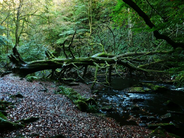
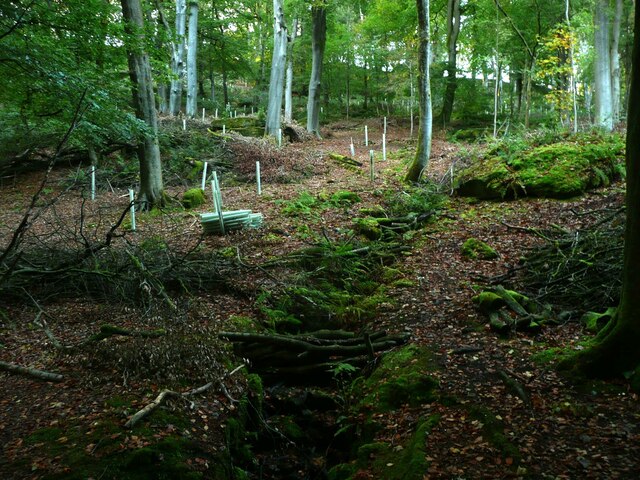
The forest boasts a diverse range of tree species, including oak, beech, ash, and birch, which provide a stunning tapestry of colors throughout the year. The foliage transforms into vibrant hues of red, orange, and gold during the autumn months, creating a breathtaking spectacle for visitors.

Nature enthusiasts flock to Purprise Wood for its abundant wildlife. The forest is home to a myriad of species, such as deer, badgers, foxes, and numerous bird species. Birdwatchers can spot woodpeckers, owls, and various songbirds, adding to the enchanting ambiance of the wood.

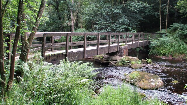
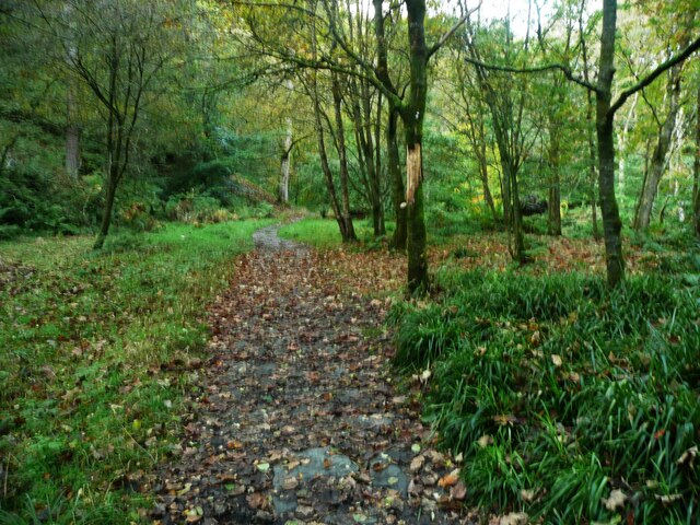
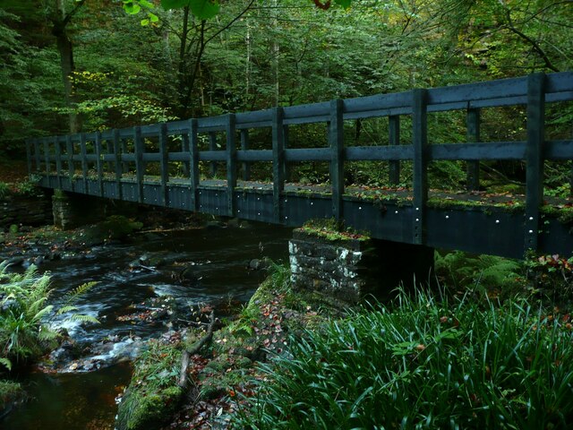
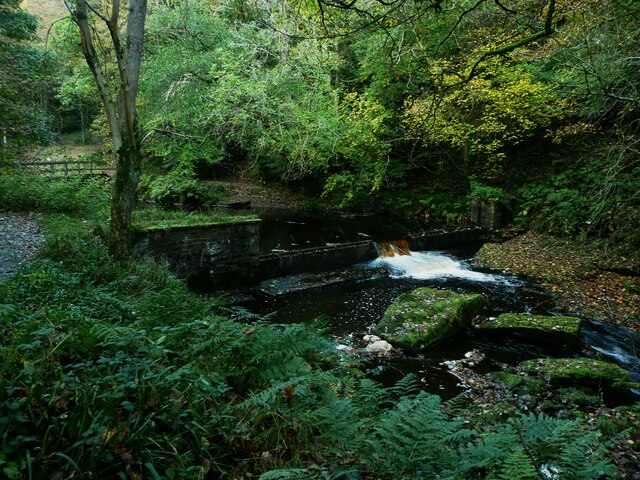
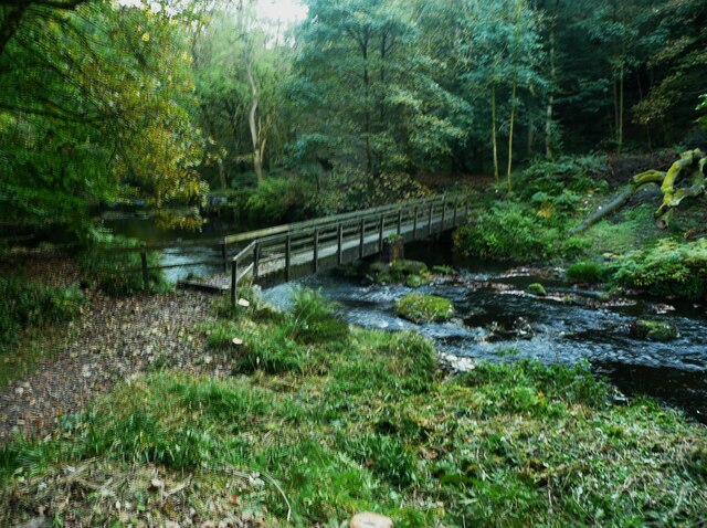
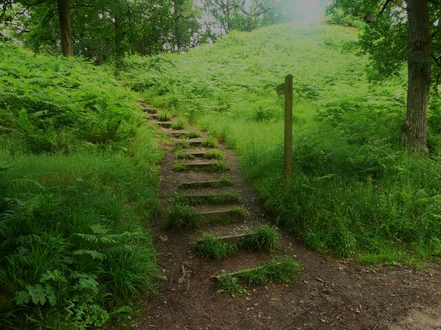
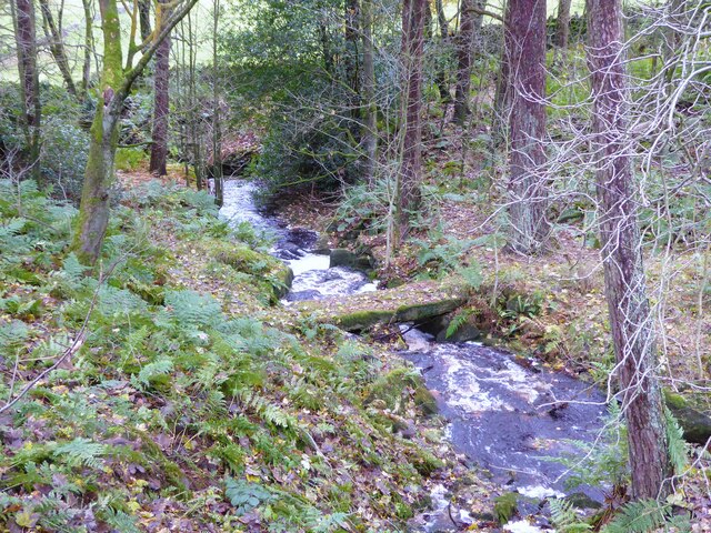
Tranquil walking trails wind their way through the forest, allowing visitors to immerse themselves in the natural wonders of Purprise Wood. The paths meander alongside babbling brooks and picturesque ponds, providing a serene and calming atmosphere.

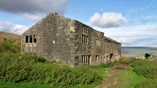
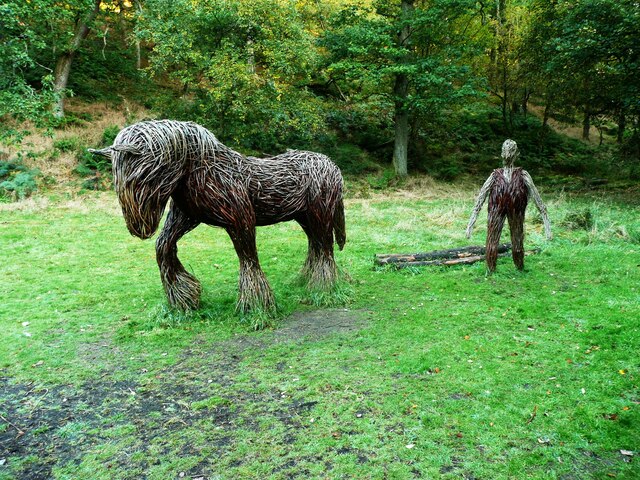
Visitors can also stumble upon ancient ruins and historical landmarks within the wood, adding a touch of mystery and intrigue to their exploration. These remnants from the past offer insight into the rich history and cultural heritage of the area.

Overall, Purprise Wood in Yorkshire is a haven for nature lovers and history enthusiasts alike. Its stunning landscapes, abundant wildlife, and fascinating history make it a must-visit destination for those seeking solace in the beauty of nature.

If you have any feedback on the listing, please let us know in the comments section below.

Purprise Wood Images

Images are sourced within 2km of 53.767075/-2.0176973 or Grid Reference SD9830. Thanks to Geograph Open Source API. All images are credited.

Willow pony A willow sculpture of what appears to be a Dales pony at Hardcastle Crags.
Willow pony
A willow sculpture of what appears to be a Dales pony at Hardcastle Crags.
Abel Cross A pair of wayside marker stones on the slopes above Crimsworth Dean
Abel Cross
A pair of wayside marker stones on the slopes above Crimsworth Dean
Helliwell Wood Farmhouse In Crimsworth Dean
Helliwell Wood Farmhouse
In Crimsworth Dean
Barker Cote Farmhouse Converted to residential
Barker Cote Farmhouse
Converted to residential
Aqueduct in Crimsworth Dean The aqueduct connects a dam on the west side of Bridge Clough with one on the east. These dams connect with ones lower down the valley and all appeared to service Midgehole Dye Works
Aqueduct in Crimsworth Dean
The aqueduct connects a dam on the west side of Bridge Clough with one on the east. These dams connect with ones lower down the valley and all appeared to service Midgehole Dye Works
Nook Farmhouse Named Nook on modern OS maps but originally Upper Sunny Bank Farmhouse with a lower Sunny Bank nearby
Nook Farmhouse
Named Nook on modern OS maps but originally Upper Sunny Bank Farmhouse with a lower Sunny Bank nearby
Hebden Water Footbridge Just south of the confluence with Rowshaw Clough
Hebden Water Footbridge
Just south of the confluence with Rowshaw Clough
Weir on Hebden Water, Hardcastle Crags
Rock outcrop, Hardcastle Crags
Path on a flat valley Floor, Hardcastle Crags This is on the Green Route.  In some places the valley is V-shaped  with little space each side of the river, and in some places it is quite wide and flat.
Path on a flat valley Floor, Hardcastle Crags
This is on the Green Route. In some places the valley is V-shaped with little space each side of the river, and in some places it is quite wide and flat.
Fallen tree across Hebden Water, Hardcastle Crags This tree makes a 'leaky dam' to help to slow flood flows to reduce flooding in Hebden Bridge downstream. This looks to have occurred naturally, but some trees trunks and poles have been placed across the river that will form dams when floating debris has lodged on them.
Fallen tree across Hebden Water, Hardcastle Crags
This tree makes a 'leaky dam' to help to slow flood flows to reduce flooding in Hebden Bridge downstream. This looks to have occurred naturally, but some trees trunks and poles have been placed across the river that will form dams when floating debris has lodged on them.
Footbridge across Hebden Water, Hardcastle Crags This is on the Green Route. The path formerly continued up the west side of the river and is still shown thus on maps. However it appears to have been eroded away and part of it has been re-routed to the east side, requiring two new footbridges.
Footbridge across Hebden Water, Hardcastle Crags
This is on the Green Route. The path formerly continued up the west side of the river and is still shown thus on maps. However it appears to have been eroded away and part of it has been re-routed to the east side, requiring two new footbridges.
New tree-planting amongst tall beeches, Hardcastle Crags "There are areas of Hardcastle Crags that are densely populated by beech trees. These trees block the light from reaching the woodland floor and have stopped plants and flowers from growing underneath them. The lack of ground vegetation is a problem for wildlife and is also a worry during periods of heavy rain. With no ground plants to slow the flow, the rainwater flows quickly to the streams taking leaf litter and soil with it - this causes blockages which increases the risk of flooding in Hebden Bridge and the local area.

We've started work to selectively fell trees across the woodland. As well as increasing the light level to help the vegetation and wildlife on the woodland floor, new homes for bats and birds will be created from the thinned beech trees, and their branches will be used to build leaky wooden dams – natural flood management techniques to help slow the flow of rainwater.

The work will be completed by carefully chosen contractors who will inspect each tree for signs of bat habitation before work starts, and new trees, including oak, rowan, birch and holly, will be planted to replace the beech trees."

From <span class="nowrap"><a title="https://www.nationaltrust.org.uk/hardcastle-crags/features/working-towards-a-healthier-woodland-at-hardcastle-crags" rel="nofollow ugc noopener" href="https://www.nationaltrust.org.uk/hardcastle-crags/features/working-towards-a-healthier-woodland-at-hardcastle-crags">Link</a><img style="margin-left:2px;" alt="External link" title="External link - shift click to open in new window" src="https://s1.geograph.org.uk/img/external.png" width="10" height="10"/></span> .
New tree-planting amongst tall beeches, Hardcastle Crags
"There are areas of Hardcastle Crags that are densely populated by beech trees. These trees block the light from reaching the woodland floor and have stopped plants and flowers from growing underneath them. The lack of ground vegetation is a problem for wildlife and is also a worry during periods of heavy rain. With no ground plants to slow the flow, the rainwater flows quickly to the streams taking leaf litter and soil with it - this causes blockages which increases the risk of flooding in Hebden Bridge and the local area. We've started work to selectively fell trees across the woodland. As well as increasing the light level to help the vegetation and wildlife on the woodland floor, new homes for bats and birds will be created from the thinned beech trees, and their branches will be used to build leaky wooden dams – natural flood management techniques to help slow the flow of rainwater. The work will be completed by carefully chosen contractors who will inspect each tree for signs of bat habitation before work starts, and new trees, including oak, rowan, birch and holly, will be planted to replace the beech trees." From LinkExternal link .
Weir on Hebden Water, Hardcastle Crags This looks like a flow measurement weir, and there is a small building nearby that might house the equipment. However an internet search suggests that it is no longer in use.
Weir on Hebden Water, Hardcastle Crags
This looks like a flow measurement weir, and there is a small building nearby that might house the equipment. However an internet search suggests that it is no longer in use.
Footbridge at the northern end of the Green Route, Hardcastle Crags
Willow sculptures, Hardcastle Crags A carthorse and a farmer.
Willow sculptures, Hardcastle Crags
A carthorse and a farmer.
Path to the crags, Hardcastle crags
Clam bridge in Rowshaw Clough This appears to be on an old Victorian track that led to Horseshoe Cascade in Rowshaw Clough which was a popular attraction. The paths if they still exist are now in private woodland.
Clam bridge in Rowshaw Clough
This appears to be on an old Victorian track that led to Horseshoe Cascade in Rowshaw Clough which was a popular attraction. The paths if they still exist are now in private woodland.
Show me another place!

Purprise Wood is located at Grid Ref: SD9830 (Lat: 53.767075, Lng: -2.0176973)

Division: West Riding

Unitary Authority: Calderdale

Police Authority: West Yorkshire

What 3 Words

///multiples.pounding.winks. Near Hebden Bridge, West Yorkshire

Related Wikis

Wainsgate Baptist Church

Wainsgate Baptist Church is a redundant chapel standing in an elevated position above the town of Hebden Bridge, West Yorkshire, England (grid reference...

Hardcastle Crags

Hardcastle Crags is a wooded Pennine valley in West Yorkshire, England, owned by the National Trust. Historically part of the West Riding of Yorkshire...

Old Town, West Yorkshire

Old Town is a village in Calderdale, West Yorkshire, England. It is situated on a hilltop above Hebden Bridge and across the Hebden valley from Heptonstall...

Heptonstall

Heptonstall is a small village and civil parish within the Calderdale borough of West Yorkshire, England, historically part of the West Riding of Yorkshire...

Chiserley

Chiserley is a hamlet located on a hilltop near the town of Hebden Bridge, in the county of West Yorkshire, England. The Hamlet falls within the Calder...

Wadsworth, West Yorkshire

Wadsworth is a civil parish in the Metropolitan Borough of Calderdale in West Yorkshire, England. It has a population of 1,456, increasing to 1,603 at...

Hepton Rural District

Hepton was a rural district in the West Riding of Yorkshire, England, from 1894 to 1974. The district included four civil parishes: Heptonstall, Blackshaw...

Birchcliffe Baptist Church

Birchcliffe Baptist Church is a redundant Baptist chapel in the town of Hebden Bridge, West Yorkshire, England. It was founded by Daniel Taylor in 1764...

Related Videos

Hebden Bridge In England - 5K HDR Walking Tour of the 4th Funkiest Town in the World

Open to Collab with Travel Companies, please send an email. Support my work; https://www.buymeacoffee.com/wasimahmed ...

Hebden Bridge England UK Winter Walking Tour 4K Relaxing No Talking West Yorkshire Vintage Town

Hebden Bridge England UK Winter Walking Tour 4K Relaxing No Talking West Yorkshire Vintage Town.

Hebden Bridge Yorkshire | voted the greatest town in Europe

Welcome to the delightful town of Hebden Bridge, a hidden gem nestled in the breathtaking beauty of West Yorkshire, England!

Trek to Lumb Hole Falls - Hiking and History #1 (Victoria Station, Hebden Bridge, Heptonstall)

This video documents the preferred route I take to Lumb Hole Falls in West Yorkshire, a beautifully quaint and underrated waterfall ...

Nearby Amenities

Located within 500m of 53.767075,-2.0176973
Bus Stop
Keighley Road Pecket Well
Local Ref: 45020907
Naptan AtcoCode: 450020907
Naptan Bearing: N
Naptan CommonName: Keighley Road Pecket Well
Naptan Crossing: Purprise Lane
Naptan Indicator: Stop 45020907
Naptan PlusbusZoneRef: LEEDS
Naptan ShortCommonName: Purprise Lane
Naptan Street: Keighley Road
Naptan Verified: no
Source: naptan_import
Lat/Long: 53.7667094/-2.0108017
Bus Stop
Keighley Road Purprise Lane
Local Ref: 45051048
Naptan AtcoCode: 450051048
Naptan Bearing: S
Naptan BusStopType: CUS
Naptan CommonName: Keighley Road Purprise Lane
Naptan Crossing: Purpise Lane
Naptan Indicator: Stop 45051048
Naptan PlusbusZoneRef: LEEDS
Naptan ShortCommonName: Purprise Lane
Naptan Street: Keighley Road
Naptan Verified: no
Source: naptan_import
Lat/Long: 53.7667454/-2.0106197
Power: pole
Lat/Long: 53.7682987/-2.0104016
Power: pole
Lat/Long: 53.7715213/-2.0181532
Bench
Source: survey;gps
Lat/Long: 53.7651107/-2.0208125
The data included in this document is from www.openstreetmap.org. The data is made available under ODbL.

Have you been to Purprise Wood?

Leave your review of Purprise Wood below (or comments, questions and feedback).