Weddell Wynd Community Woodland

Wood, Forest in Staffordshire

England

Weddell Wynd Community Woodland

Tame Valley Canal towards Spine Road Bridge
Tame Valley Canal towards Spine Road Bridge Credit: Ian S

Weddell Wynd Community Woodland is a serene and picturesque forest located in Staffordshire, England. Covering an area of approximately 50 acres, this woodland offers a peaceful and natural escape from the bustling city life.

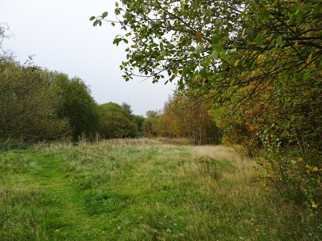
The woodland is primarily composed of deciduous and evergreen trees, creating a diverse and vibrant ecosystem. Oak, beech, and birch trees dominate the landscape, providing a sheltered habitat for a variety of wildlife species. These include birds such as woodpeckers, thrushes, and owls, as well as small mammals like squirrels, badgers, and foxes.

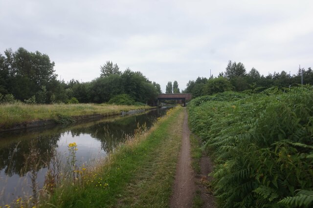
Visitors to Weddell Wynd Community Woodland can explore the numerous walking trails that wind through the forest, allowing for a tranquil and immersive experience in nature. The paths are well-maintained and suitable for all ages and fitness levels. Along the way, visitors may encounter beautiful wildflowers, rare plants, and fungi, further enhancing the natural ambiance of the woodland.

The woodland also boasts a community orchard, which is managed by local volunteers. It is home to a variety of fruit trees, including apple, pear, and plum, and serves as a communal space for residents to enjoy and participate in the upkeep of the orchard.

Weddell Wynd Community Woodland is not only a haven for wildlife and nature enthusiasts but also plays an important role in promoting environmental education and conservation. Various community events and workshops are organized throughout the year, offering opportunities for individuals to learn about the importance of forests and their role in sustaining biodiversity.

Overall, Weddell Wynd Community Woodland is a cherished natural treasure in Staffordshire, offering a tranquil retreat and fostering a sense of community and environmental stewardship among its visitors and residents.

If you have any feedback on the listing, please let us know in the comments section below.

Weddell Wynd Community Woodland Images

Images are sourced within 2km of 52.546354/-2.0618172 or Grid Reference SO9594. Thanks to Geograph Open Source API. All images are credited.

Tame Valley Canal towards Spine Road Bridge
Tame Valley Canal at Walsall Canal
Walsall Canal at Tame Valley #2 Bridge
Walsall Canal from Tame Valley #2 Bridge
Walsall Canal from Tame Valley #2 Bridge Towards Tame Valley #1 Bridge.
Walsall Canal from Tame Valley #2 Bridge
Towards Tame Valley #1 Bridge.
Walsall Canal towards Tame Valley #1 Bridge
Tame Valley Canal from the Walsall Canal
Walsall Canal at Ocker Hill Branch Bridge
Ocker Hill Branch, Walsall Canal
Walsall Canal towards Masons Brickworks Basin Bridge
Deepfield Bridge The view of the bridge over the Bradley Leg Canal.
Deepfield Bridge
The view of the bridge over the Bradley Leg Canal.
Daisy Bank Canal The view on the Bradley Leg Canal in Bilston.
Daisy Bank Canal
The view on the Bradley Leg Canal in Bilston.
Ladymoor Wood The view by the Bradley Leg Canal in Bilston.
Ladymoor Wood
The view by the Bradley Leg Canal in Bilston.
Dudley Street View The view by the Bradley Leg Canal in Bilston.
Dudley Street View
The view by the Bradley Leg Canal in Bilston.
Sankey Works Scene The view by the Bradley Leg Canal in Bilston with the former works on the right.
Sankey Works Scene
The view by the Bradley Leg Canal in Bilston with the former works on the right.
Path Wood The view from the Bankfield Road part the former Sankey Albert Street Works site in Bilston,
Path Wood
The view from the Bankfield Road part the former Sankey Albert Street Works site in Bilston,
Path Scene The view down the Bankfield Road part the former Sankey Albert Street Works site in Bilston.
Path Scene
The view down the Bankfield Road part the former Sankey Albert Street Works site in Bilston.
New Development  The view of the new development of Urban Village Houses off Dudley Street in Bilston.
New Development
The view of the new development of Urban Village Houses off Dudley Street in Bilston.
Show me another place!

Weddell Wynd Community Woodland is located at Grid Ref: SO9594 (Lat: 52.546354, Lng: -2.0618172)

Unitary Authority: Sandwell

Police Authority: West Midlands

What 3 Words

///golf.dimes.jukebox. Near Tipton, West Midlands

Related Wikis

Princes End

Princes End is an area of Tipton, West Midlands, England, near the border with Coseley (of which approximately half of the area was part of until 1966...

Princes End railway station

Princes End railway station served the area of Princes End, West Midlands, from 1864 to 1916 on the Princes End branch line. == History == The station...

Bustleholme F.C.

Bustleholme Football Club is a football club based in West Bromwich, West Midlands, England. They are currently members of the West Midlands (Regional...

Tipton Sports Academy

Tipton Sports Academy is a multi-purpose sports stadium located on Wednesbury Oak Road in Tipton, West Midlands, England. It includes a running track,...

Wednesbury Oak Loop

The Wednesbury Oak Loop, sometimes known as the Bradley Arm, is a canal in the West Midlands, England. It is part of the Birmingham Canal Navigations...

Bradley Branch

The Bradley Branch or Bradley Locks Branch was a short canal of the Birmingham Canal Navigations in the West Midlands, England. Completed in 1849, it included...

Princes End and Coseley railway station

Princes End and Coseley railway station was a station built by the Oxford, Worcester and Wolverhampton Railway in 1853. It was one of two stations in Princes...

Bradley and Moxley railway station

Bradley and Moxley railway station was a station on the Great Western Railway's London Paddington to Birkenhead via Birmingham Snow Hill line. It was opened...

Related Videos

Walking The Walsall Canal (Part 4)

Continuing my walk along the towpath of the Walsall Canal, continuing from the old Moorcroft Junction where the Walsall Canal ...

Walking The Birmingham Mainline Canal (Part 3)

Continuing with my walk along the towpath of the Birmingham Main Line Canal. Starting where I finished in part 2, at Deepfields ...

Walking The Birmingham Mainline Canal (Part 4)

Continuing my walk along the Birmingham Mainline Canal. Starting at Factory Junction where we finished in Part 3. This is where ...

4K The Black Country Living Museum - Birmingham - Walking Tour

The Black Country Living Museum (formerly The Black Country Museum) is an open-air museum of rebuilt historic buildings in ...

Nearby Amenities

Located within 500m of 52.546354,-2.0618172
Traffic Signals
Lat/Long: 52.5455314/-2.0577345
Princes End
Created By: Potlatch 0.8a
Is In: Tipton
Place: suburb
Lat/Long: 52.5424707/-2.0635612
Post Office
Prince's End Post Office
Addr City: Tipton
Addr Housenumber: 155
Addr Postcode: DY4 9JE
Addr Street: High Street
Addr Village: Princes End
Opening Hours: Mo-Sa 09:00-17:30
Ref Pol Id: 5042
Lat/Long: 52.5425066/-2.0631427
Post Box
Created By: Potlatch 0.8a
Lat/Long: 52.5453335/-2.0566276
Traffic Signals
Lat/Long: 52.5425642/-2.0625014
Mini Roundabout
Direction: clockwise
Lat/Long: 52.5443816/-2.0631718
Mini Roundabout
Direction: clockwise
Lat/Long: 52.5432554/-2.0624684
Mini Roundabout
Direction: clockwise
Lat/Long: 52.5437681/-2.0627005
Traffic Signals
Lat/Long: 52.5427157/-2.0621151
Turning Circle
Lat/Long: 52.5436885/-2.0640417
Traffic Signals
Crossing: yes
Lat/Long: 52.5422877/-2.0632428
Bus Stop
High St / Princes End Church
Bus: yes
Naptan AtcoCode: 43000969201
Naptan Bearing: SW
Naptan BusStopType: MKD
Naptan CommonName: Princes End Church
Naptan Indicator: opp
Naptan NaptanCode: nwmdmgwm
Naptan PlusbusZoneRef: BHAMNWS
Naptan Status: ACT
Naptan StopType: BCT
Naptan Street: HIGH ST
Naptan Towards: Dudley, Great Bridge
Naptan Verified: no
Public Transport: platform
Route Ref: 13;22;43
Source: WMCA
Lat/Long: 52.5438196/-2.0594495
Veterinary
Lat/Long: 52.5434215/-2.059735
The Lagoon PH
Demolished: yes
Lat/Long: 52.5427248/-2.0625248
Bus Stop
High St / The Sheperds Cottage
NaPTANAreaCode: 43009690101
Bus: yes
Naptan AtcoCode: 43009690101
Naptan Bearing: NE
Naptan BusStopType: MKD
Naptan CommonName: The Sheperds Cottage
Naptan Indicator: before
Naptan NaptanCode: nwmwadad
Naptan PlusbusZoneRef: BHAMNWS
Naptan Status: ACT
Naptan StopType: BCT
Naptan Street: HIGH ST
Naptan Towards: Wednesbury
Naptan Verified: no
Public Transport: platform
Route Ref: 13;22;43;313
Shelter: yes
Shelter Ref: 304337
Source: WMCA
Lat/Long: 52.5435208/-2.0601767
Telephone
Booth: KX100
Covered: booth
Lat/Long: 52.542096/-2.0637656
The Shepherds Cottage
Amenity Demolished: pub
Lat/Long: 52.5437071/-2.0599739
Bus Stop
High St / Upper Church Lane
NaPTANAreaCode: 43000969102
Bus: yes
Naptan AtcoCode: 43000969102
Naptan Bearing: NE
Naptan BusStopType: MKD
Naptan CommonName: Upper Church Lane
Naptan Indicator: opp
Naptan NaptanCode: nwmdmgwj
Naptan PlusbusZoneRef: BHAMNWS
Naptan Status: ACT
Naptan StopType: BCT
Naptan Street: HIGH ST
Naptan Towards: Wednesbury
Public Transport: platform
Route Ref: 13;22;43;313
Shelter: yes
Shelter Ref: 304333
Source: WMCA
Lat/Long: 52.5429689/-2.0616308
Bus Stop
High St / Princes End Post Office
Bus: yes
Public Transport: platform
Lat/Long: 52.542352/-2.0631576
Telephone
Booth: KX100
Covered: booth
Lat/Long: 52.5423972/-2.0631249
Recycling
Lat/Long: 52.5421174/-2.0633845
Turning Circle
Lat/Long: 52.5447963/-2.0622112
Turning Circle
Lat/Long: 52.544945/-2.0601777
Post Box
Collection Times: Mo-Fr 17:30; Sa 11:45
Operator: Royal Mail
Operator Wikidata: Q638098
Lat/Long: 52.550255/-2.060742
Post Box
Lat/Long: 52.5475654/-2.0687904
Weddell Wynd / Attlee Crescent
Naptan AtcoCode: 43000681801
Naptan Bearing: NE
Naptan BusStopType: CUS
Naptan CommonName: Attlee Crescent
Naptan Indicator: before
Naptan NaptanCode: nwmtawat
Naptan PlusbusZoneRef: BHAMNWS
Naptan Status: ACT
Naptan StopType: BCT
Naptan Street: WEDDELL WYND
Naptan Towards: Bilston
Naptan Verified: no
Public Transport: platform
Route Ref: 80
Source: WMCA
Lat/Long: 52.5482432/-2.0671594
Weddell Wynd / Attlee Crescent
Naptan AtcoCode: 43000681802
Naptan Bearing: E
Naptan BusStopType: CUS
Naptan CommonName: Attlee Crescent
Naptan Indicator: after
Naptan NaptanCode: nwmtawaw
Naptan PlusbusZoneRef: BHAMNWS
Naptan Status: ACT
Naptan StopType: BCT
Naptan Street: WEDDELL WYND
Naptan Towards: Moxley
Naptan Verified: no
Public Transport: platform
Route Ref: 80
Source: WMCA
Lat/Long: 52.5476758/-2.068884
Bus Stop
Union St Princes End / Grensill Avenue
Bus: yes
Naptan AtcoCode: 43000961503
Naptan Bearing: S
Naptan BusStopType: MKD
Naptan CommonName: Grensill Avenue
Naptan Indicator: opp
Naptan NaptanCode: nwmpgmwt
Naptan PlusbusZoneRef: BHAMNWS
Naptan Status: ACT
Naptan StopType: BCT
Naptan Street: UNION ST PRINCES END
Naptan Towards: Coseley
Naptan Verified: no
Public Transport: platform
Source: WMCA
Lat/Long: 52.5436236/-2.0625346
Bus Stop
Wednesbury Oak Rd / Richards Rd
Bus: yes
Naptan AtcoCode: 43000961602
Naptan Bearing: NE
Naptan BusStopType: MKD
Naptan CommonName: Richards Rd
Naptan Indicator: adj
Naptan NaptanCode: nwmdmgpm
Naptan PlusbusZoneRef: BHAMNWS
Naptan Status: ACT
Naptan StopType: BCT
Naptan Street: WEDNESBURY OAK RD
Naptan Towards: Wednesbury
Naptan Verified: no
Public Transport: platform
Route Ref: 13;313
Source: WMCA
Lat/Long: 52.5447715/-2.0591463
Bus Stop
Wednesbury Oak Rd / Richards Rd
NaPTANAreaCode: 43000961603
Bus: yes
Naptan AtcoCode: 43000961603
Naptan Bearing: SW
Naptan BusStopType: MKD
Naptan CommonName: Richards Rd
Naptan Indicator: before
Naptan NaptanCode: nwmtwtma
Naptan PlusbusZoneRef: BHAMNWS
Naptan Status: ACT
Naptan StopType: BCT
Naptan Street: WEDNESBURY OAK RD
Naptan Towards: Dudley
Naptan Verified: no
Public Transport: platform
Route Ref: 13;313
Shelter: yes
Shelter Ref: 304341
Source: WMCA
Lat/Long: 52.5450544/-2.0585178
Bus Stop
Richards Rd / Greensill Lane
Bus: yes
Naptan AtcoCode: 43000968401
Naptan Bearing: SW
Naptan BusStopType: MKD
Naptan CommonName: Greensill Lane
Naptan Indicator: adj
Naptan NaptanCode: nwmpgtpj
Naptan PlusbusZoneRef: BHAMNWS
Naptan Status: ACT
Naptan StopType: BCT
Naptan Street: RICHARDS RD
Naptan Towards: Bilston
Naptan Verified: no
Public Transport: platform
Route Ref: 22;43
Source: WMCA
Lat/Long: 52.5443071/-2.0643664
Bus Stop
Richards Rd / Greensill Lane
Bus: yes
Naptan AtcoCode: 43000968402
Naptan Bearing: NE
Naptan BusStopType: MKD
Naptan CommonName: Greensill Lane
Naptan Indicator: opp
Naptan NaptanCode: nwmpgtpm
Naptan PlusbusZoneRef: BHAMNWS
Naptan Status: ACT
Naptan StopType: BCT
Naptan Street: RICHARDS RD
Naptan Towards: Great Bridge
Naptan Verified: no
Public Transport: platform
Route Ref: 22;43
Source: WMCA
Lat/Long: 52.5443971/-2.0641453
Bus Stop
Batmans Hill Rd / Steven Drive
Bus: yes
Naptan AtcoCode: 43000968601
Naptan Bearing: N
Naptan BusStopType: MKD
Naptan CommonName: Steven Drive
Naptan Indicator: before
Naptan NaptanCode: nwmpgtwa
Naptan PlusbusZoneRef: BHAMNWS
Naptan Status: ACT
Naptan StopType: BCT
Naptan Street: BATMANS HILL RD
Naptan Towards: Bilston
Naptan Verified: no
Public Transport: platform
Route Ref: 22;43
Source: WMCA
Lat/Long: 52.5467588/-2.068853
Bus Stop
Batmans Hill Rd / Steven Drive
NaPTANAreaCode: 43000968602
Bus: yes
Naptan AtcoCode: 43000968602
Naptan Bearing: S
Naptan BusStopType: MKD
Naptan CommonName: Steven Drive
Naptan Indicator: opp
Naptan NaptanCode: nwmpgtwd
Naptan PlusbusZoneRef: BHAMNWS
Naptan Status: ACT
Naptan StopType: BCT
Naptan Street: BATMANS HILL RD
Naptan Towards: Great Bridge
Naptan Verified: no
Public Transport: platform
Route Ref: 22;43
Shelter: yes
Shelter Ref: 304328
Source: WMCA
Lat/Long: 52.5472083/-2.068839
Bus Stop
High St / Upper Church Lane
NaPTANAreaCode: 43000969101
Bus: yes
Naptan AtcoCode: 43000969101
Naptan Bearing: SW
Naptan BusStopType: MKD
Naptan CommonName: Upper Church Lane
Naptan Indicator: adj
Naptan NaptanCode: nwmdmgwg
Naptan PlusbusZoneRef: BHAMNWS
Naptan Status: ACT
Naptan StopType: BCT
Naptan Street: HIGH ST
Naptan Towards: Dudley, Great Bridge
Naptan Verified: no
Public Transport: platform
Route Ref: 13;22;43;313
Shelter: yes
Shelter Ref: 304303
Source: WMCA
Lat/Long: 52.5430772/-2.0610468
Bus Stop
Wednesbury Oak Rd / Asda
Bus: yes
Naptan AtcoCode: 43000969301
Naptan Bearing: E
Naptan BusStopType: MKD
Naptan CommonName: Asda
Naptan Indicator: opp
Naptan NaptanCode: nwmdmgwp
Naptan PlusbusZoneRef: BHAMNWS
Naptan Status: ACT
Naptan StopType: BCT
Naptan Street: WEDNESBURY OAK RD
Naptan Towards: Wednesbury
Naptan Verified: no
Public Transport: platform
Route Ref: 13;313
Source: WMCA
Lat/Long: 52.5461279/-2.0546953
Bus Stop
Richards Rd / Parkes Lane
Bus: yes
Naptan AtcoCode: 43000970001
Naptan Bearing: E
Naptan BusStopType: MKD
Naptan CommonName: Parkes Lane
Naptan Indicator: adj
Naptan NaptanCode: nwmtjgjt
Naptan PlusbusZoneRef: BHAMNWS
Naptan Status: ACT
Naptan StopType: BCT
Naptan Street: RICHARDS RD
Naptan Towards: Great Bridge
Naptan Verified: no
Public Transport: platform
Route Ref: 22;43
Source: WMCA
Lat/Long: 52.5438112/-2.0668872
Bus Stop
Batmans Hill Rd / Kerr Drive
Bus: yes
Naptan AtcoCode: 43000970801
Naptan Bearing: N
Naptan BusStopType: MKD
Naptan CommonName: Kerr Drive
Naptan Indicator: adj
Naptan NaptanCode: nwmtjgjm
Naptan PlusbusZoneRef: BHAMNWS
Naptan Status: ACT
Naptan StopType: BCT
Naptan Street: BATMANS HILL RD
Naptan Towards: Bilston
Naptan Verified: no
Public Transport: platform
Route Ref: 43
Source: WMCA
Lat/Long: 52.5438467/-2.0676835
Bus Stop
High St / Princes End Post Office
NaPTANAreaCode: 43000972001
Bus: yes
Naptan AtcoCode: 43000972001
Naptan Bearing: SW
Naptan BusStopType: MKD
Naptan CommonName: Princes End Post Office
Naptan Indicator: opp
Naptan NaptanCode: nwmtwdwt
Naptan PlusbusZoneRef: BHAMNWS
Naptan Status: ACT
Naptan StopType: BCT
Naptan Street: HIGH ST
Naptan Towards: Dudley
Naptan Verified: no
Public Transport: platform
Route Ref: 11;13;311;313
Shelter: yes
Shelter Ref: 0972001
Source: WMCA
Lat/Long: 52.5420823/-2.0638729
Bus Stop
Batmans Hill Rd / Brunel Drive
Bus: yes
Naptan AtcoCode: 43000972401
Naptan Bearing: S
Naptan BusStopType: MKD
Naptan CommonName: Brunel Drive
Naptan Indicator: opposite
Naptan NaptanCode: nwmwadjd
Naptan PlusbusZoneRef: BHAMNWS
Naptan Status: ACT
Naptan StopType: BCT
Naptan Street: BATMANS HILL RD
Naptan Towards: Princes End
Naptan Verified: no
Public Transport: platform
Route Ref: 22;43
Source: WMCA
Lat/Long: 52.5453838/-2.0681283
Bus Stop
Batmans Hill Rd / Brunel Drive
Bus: yes
Naptan AtcoCode: 43000972402
Naptan Bearing: N
Naptan BusStopType: MKD
Naptan CommonName: Brunel Drive
Naptan Indicator: adjacent
Naptan NaptanCode: nwmwadjg
Naptan PlusbusZoneRef: BHAMNWS
Naptan Status: ACT
Naptan StopType: BCT
Naptan Street: BATMANS HILL RD
Naptan Towards: Bilston
Naptan Verified: no
Public Transport: platform
Route Ref: 22;43
Source: WMCA
Lat/Long: 52.5459194/-2.068484
Bus Stop
Rocket Pool Dr / Pace Crescent
Bus: yes
Naptan AtcoCode: 43000719401
Naptan Bearing: NW
Naptan BusStopType: MKD
Naptan CommonName: Pace Crescent
Naptan Indicator: opp
Naptan NaptanCode: nwmjgjat
Naptan PlusbusZoneRef: BHAMNWS
Naptan Status: ACT
Naptan StopType: BCT
Naptan Street: ROCKET POOL DR
Naptan Towards: Bilston
Naptan Verified: no
Public Transport: platform
Route Ref: 53;530
Source: WMCA
Lat/Long: 52.5508418/-2.0614571
Bus Stop
Rocket Pool Dr / Pace Crescent
Bus: yes
Naptan AtcoCode: 43000719402
Naptan Bearing: SE
Naptan BusStopType: MKD
Naptan CommonName: Pace Crescent
Naptan Indicator: adj
Naptan NaptanCode: nwmtpagw
Naptan PlusbusZoneRef: BHAMNWS
Naptan Status: ACT
Naptan StopType: BCT
Naptan Street: ROCKET POOL DR
Naptan Towards: Rocket Pool
Naptan Verified: no
Public Transport: platform
Route Ref: 53;530
Source: WMCA
Lat/Long: 52.550779/-2.0611868
Bus Stop
Rocket Pool Dr / Meldon Drive
NaPTANAreaCode: 43000719501
Bus: yes
Naptan AtcoCode: 43000719501
Naptan Bearing: E
Naptan BusStopType: MKD
Naptan CommonName: Meldon Drive
Naptan Indicator: adj
Naptan NaptanCode: nwmjgjaw
Naptan PlusbusZoneRef: BHAMNWS
Naptan Status: ACT
Naptan StopType: BCT
Naptan Street: ROCKET POOL DR
Naptan Towards: Bilston
Public Transport: platform
Route Ref: 53;530
Shelter: yes
Shelter Ref: 104303
Source: WMCA
Lat/Long: 52.5501312/-2.0587368
Bus Stop
Rocket Pool Dr / Humphries Crescent
Bus: yes
Naptan AtcoCode: 43000719601
Naptan Bearing: W
Naptan BusStopType: MKD
Naptan CommonName: Humphries Crescent
Naptan Indicator: adj
Naptan NaptanCode: nwmjgjda
Naptan PlusbusZoneRef: BHAMNWS
Naptan Status: ACT
Naptan StopType: BCT
Naptan Street: ROCKET POOL DR
Naptan Towards: Bilston
Naptan Verified: no
Public Transport: platform
Route Ref: 53;530
Source: WMCA
Lat/Long: 52.54885/-2.058651
Richards Rd / Millington Road
Naptan AtcoCode: 43000969701
Naptan Bearing: W
Naptan BusStopType: CUS
Naptan CommonName: Millington Rd
Naptan Indicator: opp
Naptan NaptanCode: nwmpgwat
Naptan PlusbusZoneRef: BHAMNWS
Naptan Status: ACT
Naptan StopType: BCT
Naptan Street: RICHARDS RD
Naptan Towards: Bilston
Naptan Verified: no
Public Transport: platform
Route Ref: 22;43
Source: WMCA
Lat/Long: 52.5442007/-2.0614318
Bus Stop
Richards Rd / Millington Road
Bus: yes
Naptan AtcoCode: 43000969702
Naptan Bearing: E
Naptan BusStopType: MKD
Naptan CommonName: Millington Rd
Naptan Indicator: adj
Naptan NaptanCode: nwmwatgw
Naptan Status: ACT
Naptan StopType: BCT
Naptan Street: RICHARDS RD
Naptan Towards: Great Bridge
Naptan Verified: no
Public Transport: platform
Route Ref: 22;43
Source: WMCA
Lat/Long: 52.5442727/-2.0614024
Power Historic: tower
Source: OS 1:25k
Lat/Long: 52.5479752/-2.0596739
Power Historic: tower
Source: OS 1:25k
Lat/Long: 52.5482559/-2.0638702
Batmans Hill
Place: locality
Source: OS_OpenData_StreetView
Lat/Long: 52.5492782/-2.0643704
Princes End
Place: locality
Source: OS_OpenData_StreetView
Lat/Long: 52.5428507/-2.0639549
Source: bing
Traffic Calming: bump
Lat/Long: 52.5480962/-2.0672197
Source: bing
Traffic Calming: bump
Lat/Long: 52.5484258/-2.0661374
Source: bing
Traffic Calming: bump
Lat/Long: 52.5488673/-2.0657594
Wednesbury Oak
Place: locality
Source: OS_OpenData_StreetView
Lat/Long: 52.546093/-2.0598367
Generator Method: photovoltaic
Generator Output Electricity: yes
Generator Source: solar
Generator Type: solar_photovoltaic_panel
Power: generator
Lat/Long: 52.5492136/-2.0571417
Generator Method: photovoltaic
Generator Output Electricity: yes
Generator Source: solar
Generator Type: solar_photovoltaic_panel
Power: generator
Lat/Long: 52.5492691/-2.056962
Generator Method: photovoltaic
Generator Output Electricity: yes
Generator Source: solar
Generator Type: solar_photovoltaic_panel
Power: generator
Lat/Long: 52.5498791/-2.057249
Generator Method: photovoltaic
Generator Output Electricity: yes
Generator Source: solar
Generator Type: solar_photovoltaic_panel
Power: generator
Lat/Long: 52.5480915/-2.068238
Generator Method: photovoltaic
Generator Output Electricity: yes
Generator Source: solar
Generator Type: solar_photovoltaic_panel
Power: generator
Lat/Long: 52.5486167/-2.0675352
Generator Method: photovoltaic
Generator Output Electricity: yes
Generator Source: solar
Generator Type: solar_photovoltaic_panel
Power: generator
Lat/Long: 52.5485596/-2.0661807
Generator Method: photovoltaic
Generator Output Electricity: yes
Generator Source: solar
Generator Type: solar_photovoltaic_panel
Power: generator
Lat/Long: 52.5432862/-2.0640671
Generator Method: photovoltaic
Generator Output Electricity: yes
Generator Source: solar
Generator Type: solar_photovoltaic_panel
Power: generator
Lat/Long: 52.543296/-2.0639089
Generator Method: photovoltaic
Generator Output Electricity: yes
Generator Source: solar
Generator Type: solar_photovoltaic_panel
Power: generator
Lat/Long: 52.543296/-2.0637882
Cafe
Asda Café
Brand: Asda
Brand Wikidata: Q297410
Brand Wikipedia: en:Asda
Contact Phone: +44 121 556 5561
Contact Website: https://storelocator.asda.com/west-midlands/tipton/wednesbury-oak-road/cafe
Cuisine: coffee_shop
Drinking Water Refill: yes
Drinking Water Refill Network: Refill
Fixme: Location not accurate
Internet Access: wlan
Internet Access Fee: no
Opening Hours Covid19: Mo-Su off
Operator: Asda Stores Ltd
Takeaway: yes
Lat/Long: 52.544968/-2.0561868
Pharmacy
Asda
Brand: Asda
Brand Wikidata: Q297410
Brand Wikipedia: en:Asda
Contact Phone: +44 121 556 5561
Contact Website: https://storelocator.asda.com/west-midlands/tipton/wednesbury-oak-road/pharmacy
Fixme: Location not accurate
Healthcare: pharmacy
Operator: Asda Stores Ltd
Lat/Long: 52.5450887/-2.0563316
Generator Method: photovoltaic
Generator Output Electricity: yes
Generator Source: solar
Generator Type: solar_photovoltaic_panel
Location: roof
Power: generator
Source: Maxar imagery
Lat/Long: 52.547899/-2.0553567
Princes End
Abandoned Railway: station
Railway: site
Lat/Long: 52.5421506/-2.0619675
Generator Method: photovoltaic
Generator Output Electricity: yes
Generator Source: solar
Generator Type: solar_photovoltaic_panel
Location: roof
Power: generator
Lat/Long: 52.5477457/-2.0582709
Generator Method: photovoltaic
Generator Output Electricity: yes
Generator Source: solar
Generator Type: solar_photovoltaic_panel
Location: roof
Power: generator
Lat/Long: 52.5501205/-2.0613447
Generator Method: photovoltaic
Generator Output Electricity: yes
Generator Source: solar
Generator Type: solar_photovoltaic_panel
Location: roof
Power: generator
Lat/Long: 52.5506228/-2.0607117
Generator Method: photovoltaic
Generator Output Electricity: yes
Generator Source: solar
Generator Type: solar_photovoltaic_panel
Location: roof
Power: generator
Lat/Long: 52.5505396/-2.0605347
Generator Method: photovoltaic
Generator Output Electricity: yes
Generator Source: solar
Generator Type: solar_photovoltaic_panel
Location: roof
Power: generator
Lat/Long: 52.5505086/-2.0603362
Generator Method: photovoltaic
Generator Output Electricity: yes
Generator Source: solar
Generator Type: solar_photovoltaic_panel
Location: roof
Power: generator
Lat/Long: 52.5504793/-2.0602611
Generator Method: photovoltaic
Generator Output Electricity: yes
Generator Source: solar
Generator Type: solar_photovoltaic_panel
Location: roof
Power: generator
Lat/Long: 52.549287/-2.0618114
Post Box
Post Box Type: pillar
Lat/Long: 52.5424379/-2.0631692
Bicycle Parking
Bicycle Parking: stands
Capacity: 6
Covered: no
Lat/Long: 52.5423556/-2.0634441
Waste Basket
Lat/Long: 52.5423558/-2.0633453
The data included in this document is from www.openstreetmap.org. The data is made available under ODbL.

Have you been to Weddell Wynd Community Woodland?

Leave your review of Weddell Wynd Community Woodland below (or comments, questions and feedback).