Calcots Wood

Wood, Forest in Dorset

England

Calcots Wood

Minor road outside Farnham
Minor road outside Farnham Credit: Helen Steed

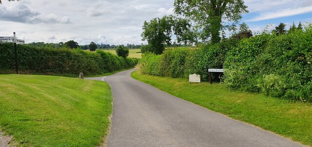
Calcots Wood is a picturesque forest located in the county of Dorset, England. Covering an area of approximately 100 hectares, this wood is a haven for nature enthusiasts and those seeking tranquility in a natural setting.

The wood is predominantly composed of deciduous trees, with a variety of oak, beech, and ash trees dominating the landscape. The trees form a dense canopy, providing shade on sunny days and shelter during inclement weather. The forest floor is covered in a rich carpet of moss, ferns, and wildflowers, creating a vibrant and colorful undergrowth.

A network of well-maintained footpaths meanders through the wood, allowing visitors to explore its beauty at their own pace. These pathways are perfect for leisurely walks, jogging, or even cycling. Birdwatchers will be delighted by the diverse avian population that calls the wood home, including woodpeckers, owls, and various songbirds.

Calcots Wood is also home to a variety of wildlife, including deer, rabbits, and squirrels. Nature enthusiasts can often spot these animals while quietly observing from one of the wood's many secluded clearings or from the specially constructed wildlife hides.

The wood is open to the public year-round, and visitors are encouraged to respect the natural environment by following designated paths and refraining from littering. With its serene atmosphere, diverse flora and fauna, and well-maintained trails, Calcots Wood is a must-visit destination for those seeking a peaceful retreat into nature in the heart of Dorset.

If you have any feedback on the listing, please let us know in the comments section below.

Calcots Wood Images

Images are sourced within 2km of 50.956624/-2.0618108 or Grid Reference ST9517. Thanks to Geograph Open Source API. All images are credited.

Minor road outside Farnham
Parkland east of Oakley Lane Part of Rushmore Park.
Parkland east of Oakley Lane
Part of Rushmore Park.
B3081 looking east Heading towards Sixpenny Handley.
B3081 looking east
Heading towards Sixpenny Handley.
Rushmore Park, avenue The remains of a once fine avenue of beech trees, at the southern entrance to the estate.
Rushmore Park, avenue
The remains of a once fine avenue of beech trees, at the southern entrance to the estate.
Rushmore Park, timber Beech trunks, awaiting collection by the roadside.
Rushmore Park, timber
Beech trunks, awaiting collection by the roadside.
Rushmore Park, footpath Skirting woodland, towards Shermel Gate.
Rushmore Park, footpath
Skirting woodland, towards Shermel Gate.
Rushmore Park, avenue A once fine avenue of beech trees leading from South Lodge. Several have disappeared or are in poor condition.
Rushmore Park, avenue
A once fine avenue of beech trees leading from South Lodge. Several have disappeared or are in poor condition.
Rushmore Park, platform Possibly used for watching equestrian events.
Rushmore Park, platform
Possibly used for watching equestrian events.
Rushmore Park, gate Entering Pollards Wood, on the path to Shermel Gate.
Rushmore Park, gate
Entering Pollards Wood, on the path to Shermel Gate.
Rushmore Park, footpath Through Pollards Wood, on the way to Shermel Gate; part of Hardy Way.
Rushmore Park, footpath
Through Pollards Wood, on the way to Shermel Gate; part of Hardy Way.
Rushmore Park, bluebells Wild bluebells under, unusually, a screen of conifers in Uddens Coppice.
Rushmore Park, bluebells
Wild bluebells under, unusually, a screen of conifers in Uddens Coppice.
Rushmore Park, marker On the path through Uddens Coppice towards Shermel Gate; on Hardy Way.
Rushmore Park, marker
On the path through Uddens Coppice towards Shermel Gate; on Hardy Way.
Rushmore Park, bluebell wood Wild bluebells in Brookes Coppice.
Rushmore Park, bluebell wood
Wild bluebells in Brookes Coppice.
Rushmore Park, golf course Part of an extensive 18-hole course: <span class="nowrap"><a title="http://www.rushmoregolfclub.co.uk/cms/" rel="nofollow ugc noopener" href="http://www.rushmoregolfclub.co.uk/cms/">Link</a><img style="margin-left:2px;" alt="External link" title="External link - shift click to open in new window" src="https://s1.geograph.org.uk/img/external.png" width="10" height="10"/></span>
Rushmore Park, golf course
Part of an extensive 18-hole course: LinkExternal link
Rushmore Park, dewpond Used by the local sheep.
Rushmore Park, dewpond
Used by the local sheep.
Rushmore Park, bluebells Wild bluebells next to the golf course.
Rushmore Park, bluebells
Wild bluebells next to the golf course.
Rushmore Park, golf course An extensive 18-hole course: <span class="nowrap"><a title="http://www.rushmoregolfclub.co.uk/cms/" rel="nofollow ugc noopener" href="http://www.rushmoregolfclub.co.uk/cms/">Link</a><img style="margin-left:2px;" alt="External link" title="External link - shift click to open in new window" src="https://s1.geograph.org.uk/img/external.png" width="10" height="10"/></span>
Rushmore Park, golf course
An extensive 18-hole course: LinkExternal link
Rushmore Park, gateway Also on the Wiltshire/Dorset boundary.
Rushmore Park, gateway
Also on the Wiltshire/Dorset boundary.
Show me another place!

Calcots Wood is located at Grid Ref: ST9517 (Lat: 50.956624, Lng: -2.0618108)

Unitary Authority: Dorset

Police Authority: Dorset

What 3 Words

///warms.seaweed.liberty. Near Bower Chalke, Wiltshire

Related Wikis

South Lodge Camp

South Lodge Camp is an archaeological site of the Bronze Age, about 0.6 miles (1.0 km) south-east of the village of Tollard Royal, in Wiltshire, England...

Woodcutts Settlement

Woodcutts Settlement is an archaeological site of the late Iron Age and Romano-British period on Cranborne Chase, England. It is situated about 1 mile...

Sandroyd School

Sandroyd School is an independent co-educational preparatory school for day and boarding pupils aged 2 to 13 in the south of Wiltshire, England. The school...

Woodcutts

Woodcutts is a hamlet within the parish of Sixpenny Handley and is located in the north of Dorset, near to the Wiltshire border. Originally named "Woodcotes...

Cranborne Chase

Cranborne Chase (grid reference ST970180) is an area of central southern England, straddling the counties Dorset, Hampshire and Wiltshire. It is part of...

King John's House, Tollard Royal

King John's House is a former manor house in the south Wiltshire village of Tollard Royal, England. Just south of the church, the building has at its core...

Tollard Royal

Tollard Royal is a village and civil parish on Cranborne Chase, Wiltshire, England. The parish is on Wiltshire's southern boundary with Dorset and the...

Cranborne Chase and West Wiltshire Downs

Cranborne Chase and West Wiltshire Downs is an Area of Outstanding Natural Beauty (AONB) covering 379 square miles (980 km2) of Dorset, Hampshire, Somerset...

Nearby Amenities

Located within 500m of 50.956624,-2.0618108
Brookes Coppice
Place: locality
Lat/Long: 50.9583214/-2.060668
Little Cartway Coppice
Place: locality
Lat/Long: 50.9603073/-2.0614587
Douglas Pleck
Place: locality
Lat/Long: 50.9597495/-2.0643199
Uddens Coppice
Place: locality
Lat/Long: 50.9572457/-2.0678055
The data included in this document is from www.openstreetmap.org. The data is made available under ODbL.

Have you been to Calcots Wood?

Leave your review of Calcots Wood below (or comments, questions and feedback).