Quarry Wood

Wood, Forest in Dorset

England

Quarry Wood

OS Bolt Benchmark PA both on Old Church in Kingston Dorset. On NW edge of the tower. picture taken viewing east.
OS Bolt Benchmark Credit: Nicholas Youell

Quarry Wood is a picturesque woodland located in Dorset, England. Covering an area of approximately 100 acres, it is a popular destination for nature lovers, hikers, and wildlife enthusiasts. The wood is known for its diverse ecosystem, consisting of a mixture of broadleaf and coniferous trees.

The wood is home to an array of wildlife, including deer, foxes, badgers, and a variety of bird species. Visitors can often spot woodpeckers, owls, and buzzards soaring above the treetops. The tranquil atmosphere of Quarry Wood makes it an ideal spot for birdwatching and nature photography.

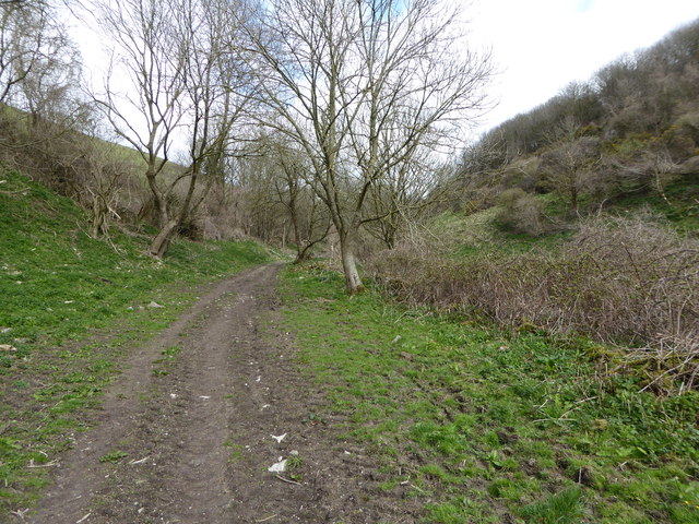
The wood is crisscrossed with a network of well-maintained footpaths, allowing visitors to explore its hidden corners and discover its natural treasures. These paths lead to a beautiful pond, fed by a small stream that runs through the wood. The pond is a haven for amphibians and provides a peaceful spot for relaxation and reflection.

In addition to its natural beauty, Quarry Wood also has a rich history. It was once a working quarry, supplying stone for local construction projects. Remnants of the quarry can still be seen, adding an interesting historical dimension to the wood.

Quarry Wood offers a peaceful escape from the hustle and bustle of everyday life, providing a sanctuary for both wildlife and visitors alike. Whether you're seeking a quiet stroll, a chance to reconnect with nature, or a glimpse into the area's history, Quarry Wood is a must-visit destination in Dorset.

If you have any feedback on the listing, please let us know in the comments section below.

Quarry Wood Images

Images are sourced within 2km of 50.611474/-2.0719694 or Grid Reference SY9579. Thanks to Geograph Open Source API. All images are credited.

OS Bolt Benchmark PA both on Old Church in Kingston Dorset. On NW edge of the tower. picture taken viewing east.
OS Bolt Benchmark
PA both on Old Church in Kingston Dorset. On NW edge of the tower. picture taken viewing east.
Landslip at Houns-tout Cliff There has been a <a href="https://www.geograph.org.uk/photo/7760481">SY9577 : Coast path closure at Houns-tout Cliff</a> since November 2023 due to a landslip in the Kimmeridge Clay. The former route down the hill can be seen ending abruptly at the cliff edge and there is a long detour inland via Kingston.
Landslip at Houns-tout Cliff
There has been a SY9577 : Coast path closure at Houns-tout Cliff since November 2023 due to a landslip in the Kimmeridge Clay. The former route down the hill can be seen ending abruptly at the cliff edge and there is a long detour inland via Kingston.
Coast path closure at Houns-tout Cliff This is the eastern start of the closure due to  the <a href="https://www.geograph.org.uk/photo/7760476">SY9577 : Landslip at Houns-tout Cliff</a>.
Coast path closure at Houns-tout Cliff
This is the eastern start of the closure due to the SY9577 : Landslip at Houns-tout Cliff.
Westhill Cottage
Westhill Cottage
Sheep below Westhill Wood
Stile and path closure notice This is on the inland diversion of the coast path, made necessary by the <a href="https://www.geograph.org.uk/photo/7760481">SY9577 : Coast path closure at Houns-tout Cliff</a>?
Stile and path closure notice
This is on the inland diversion of the coast path, made necessary by the SY9577 : Coast path closure at Houns-tout Cliff?
Approaching The Plantation, south of Kingston
The Scott Arms, Kingston
Former post office and cottages at Kingston
Entering Kingston from the south
St James’s Church, Kingston
Langton Road, towards Kingston Barn
Footpath descending into Coombe Bottom
Purbeck Way at Hill Bottom
The Scott Arms, Kingston
Country road in Kingston
St James' church, Kingston
Private woodland road, Kingston A private woodland road through the Plantation at Kingston.
Private woodland road, Kingston
A private woodland road through the Plantation at Kingston.
Show me another place!

Quarry Wood is located at Grid Ref: SY9579 (Lat: 50.611474, Lng: -2.0719694)

Unitary Authority: Dorset

Police Authority: Dorset

What 3 Words

///simulates.general.harmonica. Near Corfe Castle, Dorset

Related Wikis

Encombe House

Encombe House is a privately owned, Grade II* listed country house built in 1735 on the Encombe Estate near the village of Kingston and about 1-mile (1...

Kingston, Purbeck

Kingston is a small village on the Isle of Purbeck in the county of Dorset in southern England. == Location == Kingston is situated about two miles south...

Blashenwell Farm Pit

Blashenwell Farm Pit (grid reference SY952805) is an 11.4 hectare geological Site of Special Scientific Interest in Dorset, United Kingdom, notified in...

Scoles Manor

Scoles Manor, also known as Scoles Farm House, is former farmhouse and a Grade II* listed building, two miles from Corfe Castle in Dorset, England. It...

Nearby Amenities

Located within 500m of 50.611474,-2.0719694
Barrier: stile
Material: wood
Step Count: 2
Stile: stepover
Lat/Long: 50.6093653/-2.0722272
Bench
Backrest: no
Check Date: 2023-04-09
Direction: 293
Material: stone
Lat/Long: 50.6078041/-2.0737738
Historic: monument
Man Made: obelisk
Wikidata: Q26413475
Lat/Long: 50.6108798/-2.0752393
Power: pole
Source: survey
Lat/Long: 50.6137186/-2.0777303
Material: wood
Power: pole
Source: bing
Lat/Long: 50.6075555/-2.068651
Material: wood
Power: pole
Source: bing
Lat/Long: 50.6089036/-2.0690775
Material: wood
Power: pole
Source: bing
Transformer: distribution
Lat/Long: 50.6082245/-2.068871
Material: wood
Power: pole
Source: bing
Lat/Long: 50.6103028/-2.0695549
Material: wood
Power: pole
Source: bing
Lat/Long: 50.6096049/-2.0693269
Material: wood
Power: pole
Source: bing
Lat/Long: 50.6128167/-2.0733127
Material: wood
Power: pole
Source: survey
Lat/Long: 50.612187/-2.0709711
Location Transition: yes
Material: wood
Power: pole
Source: survey
Lat/Long: 50.6117921/-2.0706278
Material: wood
Power: pole
Source: survey
Lat/Long: 50.6113598/-2.0698983
The data included in this document is from www.openstreetmap.org. The data is made available under ODbL.

Have you been to Quarry Wood?

Leave your review of Quarry Wood below (or comments, questions and feedback).