Critchill

Settlement in Somerset Mendip

England

Critchill

Old Milestone Plate, Frome Museum
Old Milestone Plate, Frome Museum Credit: Janet Dowding

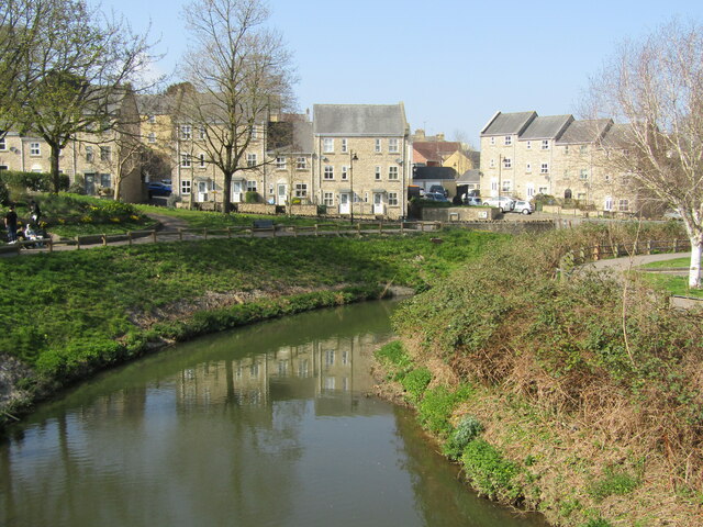
Critchill is a small village located in the county of Somerset, England. It is situated about 3 miles southwest of the town of Frome and is surrounded by beautiful countryside, offering picturesque views of the Mendip Hills. The village is nestled in a valley, with the River Frome flowing nearby.

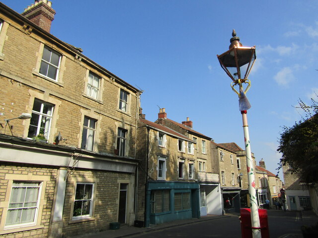
Critchill has a population of around 500 residents, making it a close-knit community. The village is known for its peaceful and tranquil atmosphere, attracting those looking for a quiet and idyllic place to live. The local residents take pride in maintaining the village's traditional charm, with many well-preserved historic buildings and cottages.

Facilities in Critchill are limited, with no shops or pubs within the village itself. However, amenities can be found in nearby Frome. The village does have a primary school, providing education for local children. Additionally, there are several community groups and events that bring the residents together, fostering a strong sense of community spirit.

Critchill is surrounded by natural beauty, offering opportunities for outdoor activities such as walking, cycling, and fishing. The nearby Mendip Hills provide ample opportunities for hiking and exploring the stunning landscapes. The village is also conveniently located for those wanting to explore the wider Somerset region, with the city of Bath and the iconic Cheddar Gorge within easy reach.

In conclusion, Critchill is a peaceful and picturesque village in Somerset, offering a close-knit community and access to beautiful countryside. It is an ideal place for those seeking a tranquil lifestyle and a love for the great outdoors.

If you have any feedback on the listing, please let us know in the comments section below.

Critchill Images

Images are sourced within 2km of 51.223713/-2.334141 or Grid Reference ST7647. Thanks to Geograph Open Source API. All images are credited.

Old Milestone Plate, Frome Museum
Old Milestone, B3090, Fromefield, Frome
View near Critchell
View near Critchell
The Blue Boar
The Blue Boar
The Royal Oak
The Royal Oak
Egford Hill Downhill towards Frome.
Egford Hill
Downhill towards Frome.
Frome Flea Market at the Cheese and Grain Takes place on Wednesdays, 9 am till 2 pm.
Frome Flea Market at the Cheese and Grain
Takes place on Wednesdays, 9 am till 2 pm.
Frome - The Blue House Historic building, former almshouses, then a Bluecoat School, now retirement flats.
Frome - The Blue House
Historic building, former almshouses, then a Bluecoat School, now retirement flats.
Frome - River Frome View from the bridge towards modern housing overlooking the river.
Frome - River Frome
View from the bridge towards modern housing overlooking the river.
Frome - George Hotel Old hostelry and the Market Cross in central Frome.
Frome - George Hotel
Old hostelry and the Market Cross in central Frome.
Frome - Parish Church St John the Baptist, an historic and venerable church in central Frome.
Frome - Parish Church
St John the Baptist, an historic and venerable church in central Frome.
Frome - Font 13th century font within St John the Baptist Church. Note also the historic font cover.
Frome - Font
13th century font within St John the Baptist Church. Note also the historic font cover.
Frome - St John the Baptist Church High cross - an interior view within Frome's historic parish church.
Frome - St John the Baptist Church
High cross - an interior view within Frome's historic parish church.
Frome - Bath Street Main street in central Frome, heading downhill from the parish church towards the Market Place.
Frome - Bath Street
Main street in central Frome, heading downhill from the parish church towards the Market Place.
Frome - Palmer Street Historic lane with many independent shops in central Frome.
Frome - Palmer Street
Historic lane with many independent shops in central Frome.
Frome - Catherine Street Historic narrow town centre street with many old stone buildings.
Frome - Catherine Street
Historic narrow town centre street with many old stone buildings.
Frome - Catherine by Gaslight Catherine Street and historic gas lamp (The Valentine Lamp) in central Frome.
Frome - Catherine by Gaslight
Catherine Street and historic gas lamp (The Valentine Lamp) in central Frome.
Show me another place!

Critchill is located at Grid Ref: ST7647 (Lat: 51.223713, Lng: -2.334141)

Administrative County: Somerset

District: Mendip

Police Authority: Avon and Somerset

What 3 Words

///rocks.matchbox.late. Near Frome, Somerset

Related Wikis

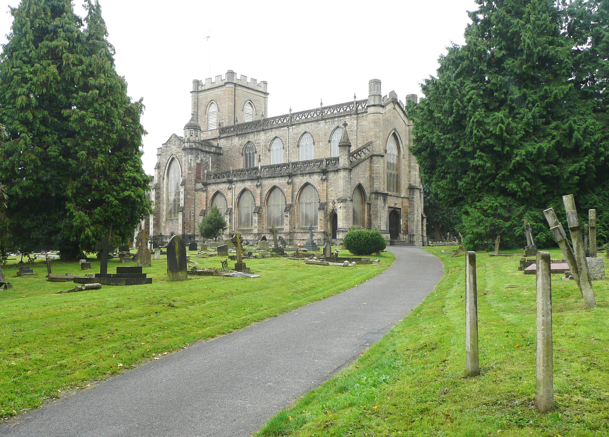
Christ Church, Frome

The Anglican Christ Church in Frome, Somerset, England, was built in 1817 and 1818. It is a Grade II* listed building. == History == The church was built...

Frome Town Hall

Frome Town Hall is a municipal building in Christchurch Street West in Frome, a town in Somerset, in England. It currently accommodates the offices and...

Frome Rural District

Frome was a rural district in Somerset, England, from 1894 to 1974. The district was created in 1894 under the Local Government Act 1894. It was abolished...

Frome

Frome ( , FROOM) is a town and civil parish in Somerset, England, on uneven high ground at the eastern end of the Mendip Hills and on the River Frome,...

Nearby Amenities

Located within 500m of 51.223713,-2.334141
Mini Roundabout
Direction: clockwise
Lat/Long: 51.2233931/-2.3291418
Critchill
Place: suburb
Source: OS_OpenData_StreetView
Lat/Long: 51.2270744/-2.3358847
Bus Stop
Westfield Road
Bus: yes
Naptan AtcoCode: 3600SOB21802
Naptan Bearing: N
Naptan CommonName: Westfield Road
Naptan Indicator: N-bound
Naptan NaptanCode: sotdjtpm
Naptan Street: Green Lane
Naptan Verified: no
Public Transport: platform
Lat/Long: 51.2247315/-2.3317674
Bus Stop
Critchill Close
Bus: yes
Naptan AtcoCode: 3600SOA56959
Naptan Bearing: SE
Naptan CommonName: Critchill Close
Naptan Indicator: SE-bound
Naptan NaptanCode: sotdpwmt
Naptan Street: Critchill Road
Naptan Verified: no
Public Transport: platform
Lat/Long: 51.2245228/-2.334823
Bus Stop
Westover
Bus: yes
Naptan AtcoCode: 3600SOB21800
Naptan Bearing: SW
Naptan CommonName: Westover
Naptan Indicator: SW-bound
Naptan NaptanCode: sotdjtmj
Naptan Street: Critchill Road
Naptan Verified: no
Public Transport: platform
Lat/Long: 51.2265557/-2.3359784
Post Box
Operator: Royal Mail
Operator Wikidata: Q638098
Lat/Long: 51.2252421/-2.3366366
Post Box
Operator: Royal Mail
Operator Wikidata: Q638098
Lat/Long: 51.2251615/-2.3318248
Shop: convenience
Lat/Long: 51.2263983/-2.3365623
NTS Computing
Operator: NTS Computing
Shop: computer
Website: https://www.ntscomputing.co.uk/
Lat/Long: 51.2255471/-2.3363559
Operator: Ks Hairdressing
Shop: hairdresser
Lat/Long: 51.2263738/-2.3365167
Communication Mobile Phone: yes
Man Made: mast
Operator: Vodafone
Operator Wikidata: Q122141
Tower Construction: tube
Tower Type: communication
Lat/Long: 51.2212269/-2.3282196
Bus Stop
Critchill Road
Bus: yes
Naptan AtcoCode: 3600SOB21801
Naptan Bearing: S
Naptan CommonName: Critchill Road
Naptan Indicator: S-bound
Naptan NaptanCode: sotdjtpa
Naptan Street: Critchill Road
Naptan Verified: no
Public Transport: platform
Lat/Long: 51.2225361/-2.3332981
Bus Stop
Marston Close
Bus: yes
Naptan AtcoCode: 3600SOA56849
Naptan Bearing: S
Naptan CommonName: Marston Close
Naptan Indicator: S-bound
Naptan NaptanCode: sotdpmjw
Naptan Street: Marston Lane
Naptan Verified: no
Public Transport: platform
Lat/Long: 51.2197313/-2.334594
Bus Stop
Marston Close
Bus: yes
Naptan AtcoCode: 3600SOA56850
Naptan Bearing: N
Naptan CommonName: Marston Close
Naptan Indicator: N-bound
Naptan NaptanCode: sotdpmpa
Naptan Street: Marston Lane
Naptan Verified: no
Public Transport: platform
Lat/Long: 51.2195995/-2.3347379
Bus Stop
Critchill Road
Bus: yes
Naptan AtcoCode: 3600SOA14109
Naptan Bearing: NW
Naptan CommonName: Critchill Road
Naptan Indicator: NW-bound
Naptan NaptanCode: sotdmpma
Naptan Street: Critchill Road
Naptan Verified: no
Public Transport: platform
Lat/Long: 51.222582/-2.3334438
Bus Stop
Critchill Close
Bus: yes
Naptan AtcoCode: 3600SOA56960
Naptan Bearing: NW
Naptan CommonName: Critchill Close
Naptan Indicator: NW-bound
Naptan NaptanCode: sotdpwmw
Naptan Street: Critchill Road
Naptan Verified: no
Public Transport: platform
Lat/Long: 51.2244142/-2.3347562
Bus Stop
Westover
Bus: yes
Naptan AtcoCode: 3600SOA14110
Naptan Bearing: NE
Naptan CommonName: Westover
Naptan Indicator: NE-bound
Naptan NaptanCode: sotdmgjm
Naptan Street: Critchill Road
Naptan Verified: no
Public Transport: platform
Lat/Long: 51.2265246/-2.3361368
Bus Stop
Manor Road
Bus: yes
Naptan AtcoCode: 3600SOB21719
Naptan Bearing: NE
Naptan CommonName: Manor Road
Naptan Indicator: NE-bound
Naptan NaptanCode: sotdjtwm
Naptan Street: The Butts
Naptan Verified: no
Public Transport: platform
Lat/Long: 51.2239253/-2.3286553
Bus Stop
Manor Road
Bus: yes
Naptan AtcoCode: 3600SOB21720
Naptan Bearing: SW
Naptan CommonName: Manor Road
Naptan Indicator: SW-bound
Naptan NaptanCode: sotdjtwt
Naptan Street: The Butts
Naptan Verified: no
Public Transport: platform
Lat/Long: 51.2238773/-2.3285646
Bus Stop
The Grove
Bus: yes
Naptan AtcoCode: 3600SOB21718
Naptan Bearing: NE
Naptan CommonName: The Grove
Naptan Indicator: NE-bound
Naptan NaptanCode: sotdjtwa
Naptan Street: Marston Road
Naptan Verified: no
Public Transport: platform
Lat/Long: 51.2210235/-2.3314115
Bus Stop
The Grove
Bus: yes
Naptan AtcoCode: 3600SOB21717
Naptan Bearing: SW
Naptan CommonName: The Grove
Naptan Indicator: SW-bound
Naptan NaptanCode: sotdjtwd
Naptan Street: Marston Road
Naptan Verified: no
Public Transport: platform
Lat/Long: 51.2206982/-2.3314475
The data included in this document is from www.openstreetmap.org. The data is made available under ODbL.

Have you been to Critchill?

Leave your review of Critchill below (or comments, questions and feedback).