Congleton Moss

Wood, Forest in Cheshire

England

Congleton Moss

Railway bridge over the canal near Congleton, Cheshire This is the Macclesfield Canal, looking north-north-west.
The railway line links Stoke-on-Trent with Macclesfield. It is part of the Stafford to Manchester branch of the West Coast Main Line.
Railway bridge over the canal near Congleton, Cheshire Credit: Roger Kidd

Congleton Moss is a small woodland area located in Cheshire, England. Situated near the town of Congleton, it covers an area of approximately 150 acres. The Moss is part of a larger ancient peat bog ecosystem, known as Congleton Moss and Astbury Mere Site of Special Scientific Interest (SSSI).

The Moss is characterized by its diverse vegetation, including heather, gorse, birch, and pine trees. It is home to a variety of wildlife, such as deer, foxes, rabbits, and numerous bird species, making it a popular spot for nature enthusiasts and birdwatchers.

The peat bog ecosystem in the Moss is of significant ecological importance. It acts as a carbon sink, storing large amounts of carbon dioxide from the atmosphere and helping mitigate climate change. Moreover, the peatlands act as natural filters, purifying water and regulating water flow in the area.

Congleton Moss has a rich history, dating back thousands of years. It was once used as a source of fuel, with peat being extracted for heating and cooking purposes. The remains of old peat-cutting industry can still be seen in some areas of the Moss.

The woodland is well-maintained, with footpaths allowing visitors to explore and enjoy the natural beauty of the area. It is a peaceful and tranquil spot, offering a respite from the hustle and bustle of nearby urban areas.

If you have any feedback on the listing, please let us know in the comments section below.

Congleton Moss Images

Images are sourced within 2km of 53.148174/-2.1907873 or Grid Reference SJ8761. Thanks to Geograph Open Source API. All images are credited.

Railway bridge over the canal near Congleton, Cheshire This is the Macclesfield Canal, looking north-north-west.
The railway line links Stoke-on-Trent with Macclesfield. It is part of the Stafford to Manchester branch of the West Coast Main Line.
Railway bridge over the canal near Congleton, Cheshire
This is the Macclesfield Canal, looking north-north-west. The railway line links Stoke-on-Trent with Macclesfield. It is part of the Stafford to Manchester branch of the West Coast Main Line.
Railway bridge over the canal near Congleton, Cheshire A telephoto assisted image.
This is the Macclesfield Canal, looking north-north-west. Ahead, beyond the railway bridge, is Galleys Bridge, No 70.
The railway line links Stoke-on-Trent with Macclesfield. It is part of the Stafford to Manchester branch of the West Coast Main Line.
Railway bridge over the canal near Congleton, Cheshire
A telephoto assisted image. This is the Macclesfield Canal, looking north-north-west. Ahead, beyond the railway bridge, is Galleys Bridge, No 70. The railway line links Stoke-on-Trent with Macclesfield. It is part of the Stafford to Manchester branch of the West Coast Main Line.
Macclesfield Canal near Congleton, Cheshire Looking north-north-west, about half a mile north-east of the town centre.
Macclesfield Canal near Congleton, Cheshire
Looking north-north-west, about half a mile north-east of the town centre.
Canal footbridge near Congleton in Cheshire Looking north-north-west on the Macclesfield Canal, this footbridge carries a public footpath.
Canal footbridge near Congleton in Cheshire
Looking north-north-west on the Macclesfield Canal, this footbridge carries a public footpath.
Porters Farm Bridge near Congleton in Cheshire Porters Farm Bridge is No 72 across the Macclesfield Canal and carries an unsurfaced section of Brookhouse Lane.
Porters Farm Bridge near Congleton in Cheshire
Porters Farm Bridge is No 72 across the Macclesfield Canal and carries an unsurfaced section of Brookhouse Lane.
Canal aqueduct near Congleton in Cheshire This is the Macclesfield Canal, looking north-north-east as it crosses the former North Staffordshire Railway (Biddulph Valley Branch). <span class="nowrap"><a title="https://en.wikipedia.org/wiki/Biddulph_Valley_line" rel="nofollow ugc noopener" href="https://en.wikipedia.org/wiki/Biddulph_Valley_line">Link</a><img style="margin-left:2px;" alt="External link" title="External link - shift click to open in new window" src="https://s1.geograph.org.uk/img/external.png" width="10" height="10"/></span>
Canal aqueduct near Congleton in Cheshire
This is the Macclesfield Canal, looking north-north-east as it crosses the former North Staffordshire Railway (Biddulph Valley Branch). LinkExternal link
Macclesfield Canal near Congleton, Cheshire This is the Macclesfield Canal, looking north-north-east as it crosses the former North Staffordshire Railway (Biddulph Valley Branch). <span class="nowrap"><a title="https://en.wikipedia.org/wiki/Biddulph_Valley_line" rel="nofollow ugc noopener" href="https://en.wikipedia.org/wiki/Biddulph_Valley_line">Link</a><img style="margin-left:2px;" alt="External link" title="External link - shift click to open in new window" src="https://s1.geograph.org.uk/img/external.png" width="10" height="10"/></span>
Macclesfield Canal near Congleton, Cheshire
This is the Macclesfield Canal, looking north-north-east as it crosses the former North Staffordshire Railway (Biddulph Valley Branch). LinkExternal link
Macclesfield Canal near Congleton, Cheshire Looking south-east, approaching Hightown. The houses are in Minton Close. It looks as though there might have been a bridge here, but Victorian 6" OS maps don't show it.
Macclesfield Canal near Congleton, Cheshire
Looking south-east, approaching Hightown. The houses are in Minton Close. It looks as though there might have been a bridge here, but Victorian 6" OS maps don't show it.
Macclesfield Canal near Congleton, Cheshire Looking west-south-west approaching Hightown.
Macclesfield Canal near Congleton, Cheshire
Looking west-south-west approaching Hightown.
Footpath to Dane-in-Shaw Pasture near Congleton Seen from the Macclesfield Canal.
Footpath to Dane-in-Shaw Pasture near Congleton
Seen from the Macclesfield Canal.
Galley Bridge in Congleton, Staffordshire Galley Bridge is No 73 across the Macclesfield Canal and carries Henshall Hall Drive.
Galley Bridge in Congleton, Staffordshire
Galley Bridge is No 73 across the Macclesfield Canal and carries Henshall Hall Drive.
Macclesfield Canal in Congleton, Staffordshire Looking west from Galley Bridge, No 73.
Macclesfield Canal in Congleton, Staffordshire
Looking west from Galley Bridge, No 73.
Canal bridges in Congleton, Cheshire This is the Macclesfied Canal, looking west as it passes through Hightown.
Hightown Bridge is No 74, and carries the Morley Drive cul-de-sac, which serves the John Morley dried fruit importer warehouse. Next are the A527 flyover, and Park Lane Bridge (No 75), followed by a railway bridge, then Morris Bridge (No 76), which is a turnover bridge allowing the towpath to change sides.
Canal bridges in Congleton, Cheshire
This is the Macclesfied Canal, looking west as it passes through Hightown. Hightown Bridge is No 74, and carries the Morley Drive cul-de-sac, which serves the John Morley dried fruit importer warehouse. Next are the A527 flyover, and Park Lane Bridge (No 75), followed by a railway bridge, then Morris Bridge (No 76), which is a turnover bridge allowing the towpath to change sides.
Bridges at Park Lane at Congleton in Cheshire This is the Macclesfied Canal, looking west as it passes through Hightown.
The A529 Park Lane flyover overtops the original Park Lane Bridge, No 75. Beyond them are a railway bridge, then Morris Bridge (No 76), which is a turnover bridge allowing the towpath to change sides.
Bridges at Park Lane at Congleton in Cheshire
This is the Macclesfied Canal, looking west as it passes through Hightown. The A529 Park Lane flyover overtops the original Park Lane Bridge, No 75. Beyond them are a railway bridge, then Morris Bridge (No 76), which is a turnover bridge allowing the towpath to change sides.
Canal at Park Lane Bridge in Congleton, Cheshire This is the Macclesfied Canal, looking west as it passes through Hightown.
Park Lane Bridge is No 75 across the canal in Congleton. It used to carry the A529 but that now crosses on the flyover, out of sight above bridge 75. <a title="https://www.geograph.org.uk/photo/6921414" href="https://www.geograph.org.uk/photo/6921414">Link</a> Ahead is a railway bridge, then Morris Bridge (No 76), which is a turnover bridge allowing the towpath to change sides.
Canal at Park Lane Bridge in Congleton, Cheshire
This is the Macclesfied Canal, looking west as it passes through Hightown. Park Lane Bridge is No 75 across the canal in Congleton. It used to carry the A529 but that now crosses on the flyover, out of sight above bridge 75. Link Ahead is a railway bridge, then Morris Bridge (No 76), which is a turnover bridge allowing the towpath to change sides.
Macclesfield Canal in Hightown, Congleton Looking east towards the railway bridge.
Macclesfield Canal in Hightown, Congleton
Looking east towards the railway bridge.
Show me another place!

Congleton Moss is located at Grid Ref: SJ8761 (Lat: 53.148174, Lng: -2.1907873)

Unitary Authority: Cheshire East

Police Authority: Cheshire

What 3 Words

///about.hints.note. Near Congleton, Cheshire

Nearby Locations

Mossley Congleton Moss

Related Wikis

Astbury, Cheshire

Astbury was one of the eight ancient parishes of the Macclesfield Hundred of Cheshire, England. It included two chapelries and ten townships. The chapelry...

Congleton railway station

Congleton railway station is a mainline station serving the Cheshire market town of Congleton. It lies on the Stafford-Manchester branch of the West Coast...

St Peter's Church, Congleton

St Peter's Church is in Chapel Street, Congleton, Cheshire, England. It is recorded in the National Heritage List for England as a designated Grade I...
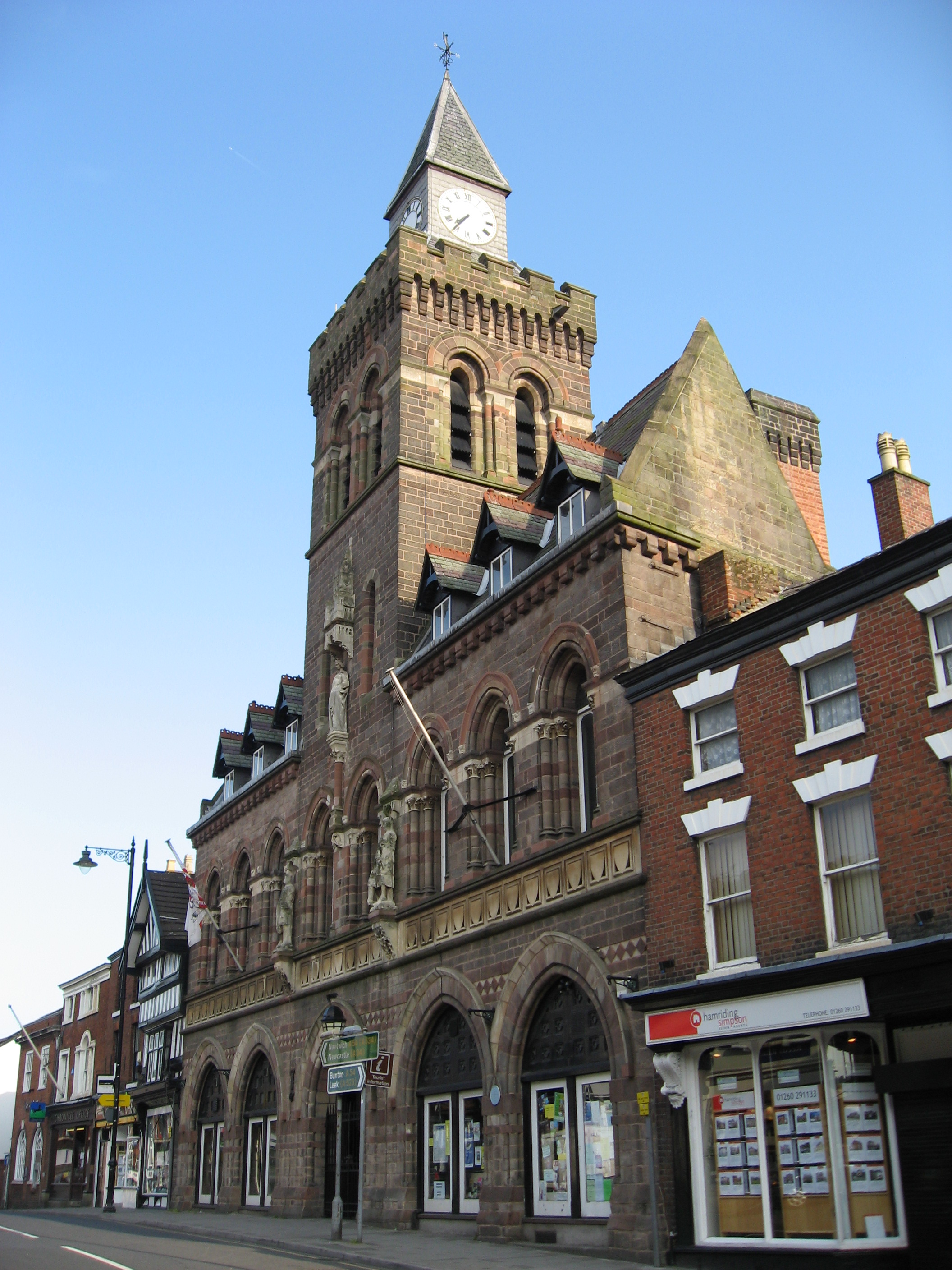
Congleton Town Hall

Congleton Town Hall is a municipal building in the High Street, Congleton, Cheshire, England. The town hall, which is the meeting place of Congleton Town...
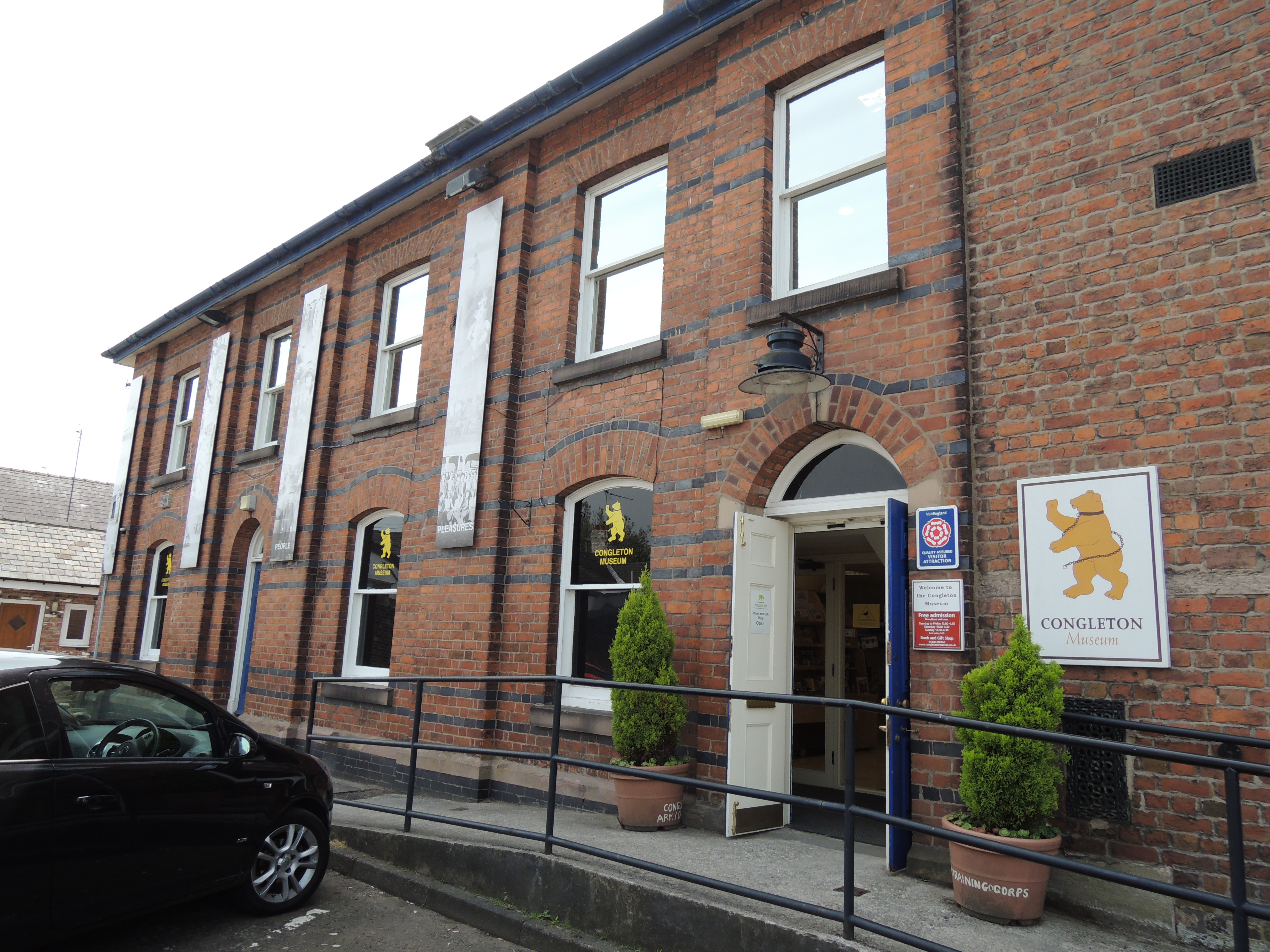
Congleton Museum

Congleton Museum is a local museum in Congleton, Cheshire, northwest England, covering the history of the town of Congleton, which is situated on the banks...

Education in Congleton Borough

In Congleton Borough, there were many different provisions for children and young people ranging from pre-schooling to Colleges of Further education. The...

Congleton

Congleton is a market town and civil parish in the unitary authority of Cheshire East in Cheshire, England. The town is by the River Dane, 21 miles (34...

Congleton Park

Congleton Park is a public park in Congleton, in Cheshire, England. It is listed Grade II in Historic England's Register of Parks and Gardens, and the...

Nearby Amenities

Located within 500m of 53.148174,-2.1907873
Addr Housename: Little Moss Farm
Lat/Long: 53.1497234/-2.1850662
The data included in this document is from www.openstreetmap.org. The data is made available under ODbL.

Have you been to Congleton Moss?

Leave your review of Congleton Moss below (or comments, questions and feedback).