Lodge Covert

Wood, Forest in Staffordshire Stafford

England

Lodge Covert

St Mary's St Mary's Church Swynnerton.
St Mary's Credit: Andy and Hilary

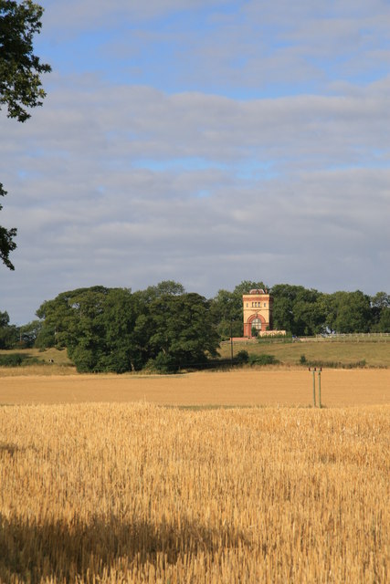
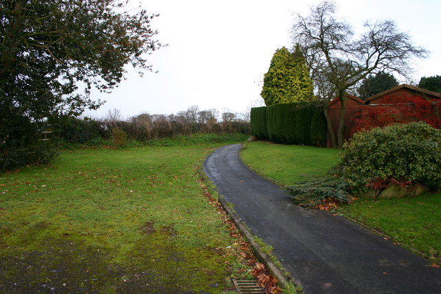
Lodge Covert is a picturesque woodland located in Staffordshire, England. Situated in the heart of the county, it covers an area of approximately 100 acres and is renowned for its natural beauty and diverse ecosystem.

The woodland is predominantly composed of mature trees, including oak, beech, and birch, which provide a dense canopy and create a tranquil and peaceful atmosphere. The forest floor is covered with a rich carpet of ferns, mosses, and wildflowers, adding to the area's enchanting charm.

Lodge Covert is home to a variety of wildlife, making it a popular destination for nature enthusiasts and birdwatchers. The wood is inhabited by numerous bird species, including woodpeckers, owls, and various songbirds. Additionally, visitors may spot mammals such as deer, foxes, and rabbits, as well as smaller creatures like squirrels and hedgehogs.

The woodland offers a range of walking trails, allowing visitors to explore and appreciate its natural wonders. These trails meander through the forest, passing by small streams and hidden clearings. There are also designated picnic areas where visitors can relax and enjoy the peaceful surroundings.

Lodge Covert is managed by the local authorities, who ensure its conservation and protection. The woodland is open to the public throughout the year, with no admission fees. It provides an ideal escape from the hustle and bustle of everyday life, offering a serene environment for relaxation and an opportunity to connect with nature.

If you have any feedback on the listing, please let us know in the comments section below.

Lodge Covert Images

Images are sourced within 2km of 52.920322/-2.2044626 or Grid Reference SJ8635. Thanks to Geograph Open Source API. All images are credited.

St Mary's St Mary's Church Swynnerton.
St Mary's
St Mary's Church Swynnerton.
The Winding Road Old cottage and winding road to Swynnerton.
The Winding Road
Old cottage and winding road to Swynnerton.
Water Tower, Swynnerton The north edge of the tower is bang on the grid line. The tower is now a dwelling but there is a reservoir adjoining it and it was associated with the italianate Hatton Pumping Station.
Water Tower, Swynnerton
The north edge of the tower is bang on the grid line. The tower is now a dwelling but there is a reservoir adjoining it and it was associated with the italianate Hatton Pumping Station.
M6 Motorway Looking north along the M6 from the bridge on the A51, Stone to Nantwich road
M6 Motorway
Looking north along the M6 from the bridge on the A51, Stone to Nantwich road
Swynnerton Swynnerton Memorial with St Mary's Church in the background
Swynnerton
Swynnerton Memorial with St Mary's Church in the background
Broken Stile This broken stile is on a public footpath from Yarnfield to Swynnerton. At this point during the time I was here there was an almost constant sound of armoury being fired from Swynnerton army camp and helicopters flying overhead.
Broken Stile
This broken stile is on a public footpath from Yarnfield to Swynnerton. At this point during the time I was here there was an almost constant sound of armoury being fired from Swynnerton army camp and helicopters flying overhead.
Broken Stile Ahead This public footpath, across very boggy ground, goes from Yarnfield to Swynnerton. At this point, gunfire and heavier artillery being fired can be heard from Swynnerton Army Camp.
Broken Stile Ahead
This public footpath, across very boggy ground, goes from Yarnfield to Swynnerton. At this point, gunfire and heavier artillery being fired can be heard from Swynnerton Army Camp.
Derelict Farm Buildings This is Blakelow Farm. These farm buildings appear to be derelict although I heard work in progress at the location.
Derelict Farm Buildings
This is Blakelow Farm. These farm buildings appear to be derelict although I heard work in progress at the location.
A51 towards Stone This is the A51 looking towards the Darlaston Roundabout where the road joins the A34 north of Stone.
A51 towards Stone
This is the A51 looking towards the Darlaston Roundabout where the road joins the A34 north of Stone.
Saxon Lowe This is a view of Saxon Lowe on Tittensor Chase, from a public footpath.  Unfortunately this is on private land so a closer, circumnavigation of the hill is unable to be made... yet.
Saxon Lowe
This is a view of Saxon Lowe on Tittensor Chase, from a public footpath. Unfortunately this is on private land so a closer, circumnavigation of the hill is unable to be made... yet.
Village Footpath This is a footpath on the very edge of Swynnerton, of a road named Fairbanks Walk.
Village Footpath
This is a footpath on the very edge of Swynnerton, of a road named Fairbanks Walk.
A51 to Chester This view is at the top of Bury Bank, Darlaston near Stone, on the A51 looking towards Chester.
A51 to Chester
This view is at the top of Bury Bank, Darlaston near Stone, on the A51 looking towards Chester.
Track to Tittensor This track runs from Bury Bank on the A51 near to Stone and goes to Tittensor.
Track to Tittensor
This track runs from Bury Bank on the A51 near to Stone and goes to Tittensor.
An Off-Road Route to Bury Bank This path runs from Tittensor Chase to Bury Bank.
An Off-Road Route to Bury Bank
This path runs from Tittensor Chase to Bury Bank.
Footpath Across Fields This view is taken at the edge of Tittensor Chase and looking towards Bury Bank on the A51 near to Stone. The A51 can just be made out in the distance to the mid-left of the photo.
Footpath Across Fields
This view is taken at the edge of Tittensor Chase and looking towards Bury Bank on the A51 near to Stone. The A51 can just be made out in the distance to the mid-left of the photo.
Tittensor Chase A view of Tittensor Chase at the very edge of the woodland. Beyond the trees you can make out the mound of Saxon's Low in a clearing, another photo is submitted.
Tittensor Chase
A view of Tittensor Chase at the very edge of the woodland. Beyond the trees you can make out the mound of Saxon's Low in a clearing, another photo is submitted.
A Worn Out Stile A stile that is need of some TLC on a path from Tittensor Chase to Bury Bank, on the A51 near Stone. The A51 can just be made out in the distance.
A Worn Out Stile
A stile that is need of some TLC on a path from Tittensor Chase to Bury Bank, on the A51 near Stone. The A51 can just be made out in the distance.
A Forest Track A forest track through Tittensor Chase
A Forest Track
A forest track through Tittensor Chase
Show me another place!

Lodge Covert is located at Grid Ref: SJ8635 (Lat: 52.920322, Lng: -2.2044626)

Administrative County: Staffordshire

District: Stafford

Police Authority: Staffordshire

What 3 Words

///adults.chip.smoke. Near Barlaston, Staffordshire

Nearby Locations

Lodge Covert

Related Wikis

Swynnerton

Swynnerton is a village and civil parish in Staffordshire, England. It lies in the Borough of Stafford, and at the 2001 census had a population of 4,233...

Swynnerton Hall

Swynnerton Hall is an 18th-century country mansion house, the home of Lord Stafford, situated at Swynnerton near Stone, Staffordshire. It is a Grade I...

Beechcliff

Beechcliff is a village in Staffordshire, England. For population details at the 2011 census see Swynnerton

Bury Bank

Bury Bank is an Iron Age hillfort in Staffordshire, England, about 1.5 miles (2.4 km) north-west of Stone and near the village of Meaford. It is a scheduled...

Dorlestone Hall

Dorlestone Hall was a manor house at Darlaston, a locality also known as Dorlestone, near Stone, Staffordshire, England, on the Trent. The Hall was built...

Meaford Hall, Staffordshire

Meaford Hall in Staffordshire, England is a 17th-century country house at Meaford, near Stone, Staffordshire. The River Trent runs through the estate's...

Meaford Power Station

Meaford Power Station was a coal-fired power station situated on the River Trent at Meaford near Stone in Staffordshire. == History == === Meaford A... ===

Tittensor

Tittensor village is located in Staffordshire, England, between Newcastle-under-Lyme and Stone. The population as taken at the 2011 census can be found...

Nearby Amenities

Located within 500m of 52.920322,-2.2044626
Historic Power: pole
Lat/Long: 52.9185888/-2.1976304
Historic Power: pole
Lat/Long: 52.917447/-2.1988454
Barrier: stile
Lat/Long: 52.9165789/-2.2041243
Power: pole
Lat/Long: 52.9190741/-2.2107734
Power: pole
Lat/Long: 52.9185128/-2.209156
Material: wood
Power: pole
Lat/Long: 52.9192448/-2.2057088
Material: wood
Power: pole
Lat/Long: 52.9196481/-2.2045409
Material: wood
Power: pole
Lat/Long: 52.9198977/-2.2038968
Material: wood
Power: pole
Lat/Long: 52.9201175/-2.2031889
Material: wood
Power: pole
Lat/Long: 52.920843/-2.2011185
Power: pole
Lat/Long: 52.9212655/-2.1999293
Power: pole
Lat/Long: 52.9216539/-2.1987472
Power: pole
Lat/Long: 52.9221112/-2.1976866
Power: pole
Lat/Long: 52.9222527/-2.1986651
Speed Camera
Lat/Long: 52.9171842/-2.1999873
Power: pole
Lat/Long: 52.9243726/-2.202461
Power: pole
Lat/Long: 52.9240333/-2.2015903
Power: pole
Lat/Long: 52.9227798/-2.1989164
Covert Lodge
Brand: National Grid
Brand Wikidata: Q1465461
Operator: National Grid Electricity Distribution Plc
Operator Old: Western Power Distribution
Operator Wikidata: Q7988183
Owner: National Grid Electricity Distribution (West Midlands) Plc
Owner Wikidata: Q114397791
Power: pole
Ref: 86/0093
Transformer: distribution
Lat/Long: 52.9223583/-2.2001726
Addr Housename: The Bungalow
Lat/Long: 52.9223935/-2.2005902
The data included in this document is from www.openstreetmap.org. The data is made available under ODbL.

Have you been to Lodge Covert?

Leave your review of Lodge Covert below (or comments, questions and feedback).