Great Plantation

Wood, Forest in Yorkshire Pendle

England

Great Plantation

Moorcock Inn Located on a bend on the A682, this popular country pub dates from the 18th century. It is seen here in 1996 when it was a Thwaites house.
Moorcock Inn Credit: Stephen McKay

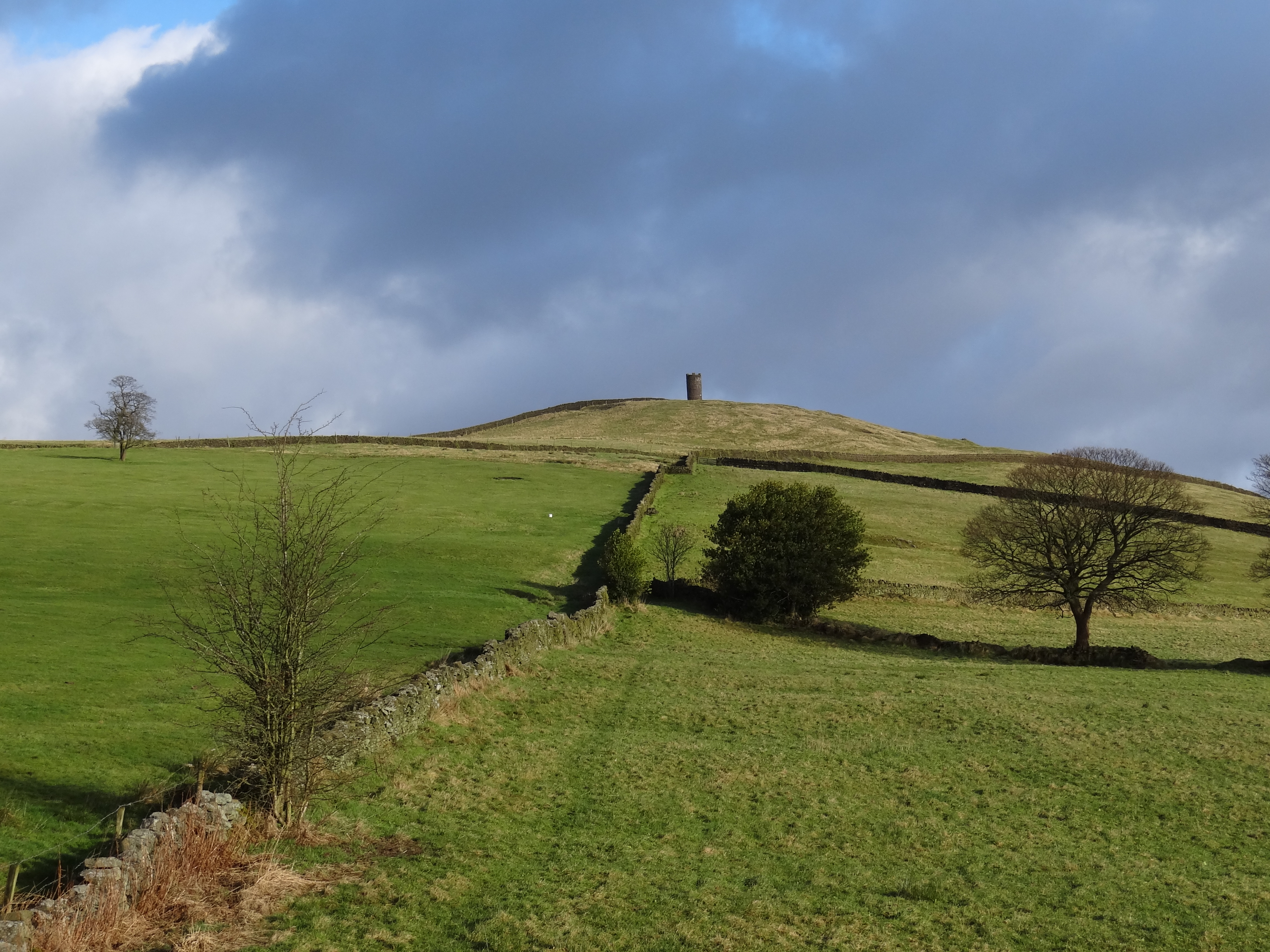
Great Plantation, Yorkshire, also known as Wood or Forest, is a sprawling woodland located in the county of Yorkshire, England. Covering an extensive area of approximately 500 acres, it is considered one of the largest plantations in the region.

The Great Plantation is characterized by its diverse range of trees, including oak, beech, birch, and pine, creating a picturesque landscape throughout the year. The woodland is a haven for wildlife, boasting a rich and varied ecosystem that supports a wide array of flora and fauna. Visitors to the plantation may spot deer, foxes, rabbits, and a multitude of bird species, making it a popular destination for nature enthusiasts and birdwatchers.

The plantation offers a variety of recreational activities, making it a favorite spot for locals and tourists alike. There are numerous walking trails and designated paths for cycling, allowing visitors to explore the woodland at their own pace. Additionally, the plantation features picnic areas and designated camping spots, providing opportunities for outdoor gatherings and overnight stays.

Great Plantation, Yorkshire, also has historical significance, as it was once part of a larger estate that belonged to a prominent local family. The plantation's history is evident through the presence of old ruins and remnants of the estate's structures, adding a touch of intrigue and charm to the woodland.

Overall, Great Plantation, Yorkshire, is a captivating natural treasure that offers a serene escape from the bustling city life. Its diverse ecosystem, recreational activities, and historical elements make it a must-visit destination for nature lovers and history enthusiasts alike.

If you have any feedback on the listing, please let us know in the comments section below.

Great Plantation Images

Images are sourced within 2km of 53.890494/-2.2196419 or Grid Reference SD8543. Thanks to Geograph Open Source API. All images are credited.

Moorcock Inn Located on a bend on the A682, this popular country pub dates from the 18th century. It is seen here in 1996 when it was a Thwaites house.
Moorcock Inn
Located on a bend on the A682, this popular country pub dates from the 18th century. It is seen here in 1996 when it was a Thwaites house.
Footpath to Admergill The path follows the line of a fence towards the valley bottom.
Footpath to Admergill
The path follows the line of a fence towards the valley bottom.
Old county boundary sign (1) A short distance beyond this modern sign was the pre-1974 boundary between Lancashire and the West Riding of Yorkshire. The County Palatine gained from those boundary changes.
Old county boundary sign (1)
A short distance beyond this modern sign was the pre-1974 boundary between Lancashire and the West Riding of Yorkshire. The County Palatine gained from those boundary changes.
Old county boundary sign (2) This stone marks the pre-1974 boundary between Lancashire and the West Riding of Yorkshire. The County Palatine gained from those boundary changes. See also <a href="https://www.geograph.org.uk/photo/6072841">SD8541 : Old Boundary Marker by the A682, Gisburn Road, Blacko Laiths</a>. Milestone Society National ID: LA_GNBU05cb.
Old county boundary sign (2)
This stone marks the pre-1974 boundary between Lancashire and the West Riding of Yorkshire. The County Palatine gained from those boundary changes. See also SD8541 : Old Boundary Marker by the A682, Gisburn Road, Blacko Laiths. Milestone Society National ID: LA_GNBU05cb.
Icy track to Admergill It may look fairly clear, but when I started walking down it became obvious that the snow had just been compacted into ice by vehicles either side of a central strip.
Icy track to Admergill
It may look fairly clear, but when I started walking down it became obvious that the snow had just been compacted into ice by vehicles either side of a central strip.
Barn at Admergill The hall <a href="https://www.geograph.org.uk/photo/144102">SD8542 : Admergill Hall</a> is off to the left.
Barn at Admergill
The hall SD8542 : Admergill Hall is off to the left.
Admergill Hall Farm The nearer building is a modern extension to the old farmhouse. The hall <a href="https://www.geograph.org.uk/photo/144102">SD8542 : Admergill Hall</a> is further along the track.
Admergill Hall Farm
The nearer building is a modern extension to the old farmhouse. The hall SD8542 : Admergill Hall is further along the track.
Footpath beyond Admergill Hall Part of the Pendle Way heading for Weets Hill.
Footpath beyond Admergill Hall
Part of the Pendle Way heading for Weets Hill.
Small frozen pond  With a distant view of Stansfield Tower.
Small frozen pond
With a distant view of Stansfield Tower.
Recent tree planting east of Admergill Water Fairly recent maps show this as a wooded area, so perhaps the trees have been felled and replanted.
Recent tree planting east of Admergill Water
Fairly recent maps show this as a wooded area, so perhaps the trees have been felled and replanted.
Clapper bridge over Admergill Water The bridge is on a footpath forming part of the Pendle Way. See <a href="https://www.geograph.org.uk/photo/5810013">SD8542 : Footbridge and stile on the Pendle Way</a> for a summer view.
Clapper bridge over Admergill Water
The bridge is on a footpath forming part of the Pendle Way. See SD8542 : Footbridge and stile on the Pendle Way for a summer view.
Stile on the Pendle Way Where it joins the A682 above Blacko.
Stile on the Pendle Way
Where it joins the A682 above Blacko.
The Pendle Way crosses the A682 The path crosses a stile at the photographer position, and another one across the road a short distance further along.
The Pendle Way crosses the A682
The path crosses a stile at the photographer position, and another one across the road a short distance further along.
Possible former quarry by the A682 This looks like a small quarry or delph at first sight, but as a stream flows through it it could be due to natural erosion.
Possible former quarry by the A682
This looks like a small quarry or delph at first sight, but as a stream flows through it it could be due to natural erosion.
Valley View Pendle This former barn opposite the former Woodcock pub is now run as an 'adults only glamping pod'.
Valley View Pendle
This former barn opposite the former Woodcock pub is now run as an 'adults only glamping pod'.
Hamish's cafe on the A682 The nearer part (modern single storey extension) of the former Moorcock pub is currently being run as a cafe. The original pub is owned by another business.
Hamish's cafe on the A682
The nearer part (modern single storey extension) of the former Moorcock pub is currently being run as a cafe. The original pub is owned by another business.
The Renewable Heating Centre This is the former Moorcock pub at Blacko, which was still operating as such in 2018 <a href="https://www.geograph.org.uk/photo/5870345">SD8643 : The Moorcock Inn</a> but was presumably a victim of the Covid pandemic. The original pub building is now occupied by a heating business, and the newer part as a cafe  <a href="https://www.geograph.org.uk/photo/7361533">SD8643 : Hamish's cafe on the A682</a>.
The Renewable Heating Centre
This is the former Moorcock pub at Blacko, which was still operating as such in 2018 SD8643 : The Moorcock Inn but was presumably a victim of the Covid pandemic. The original pub building is now occupied by a heating business, and the newer part as a cafe SD8643 : Hamish's cafe on the A682.
View towards Blacko Hill Stansfield Tower on the hill top was visible throughout most of my circular walk, but there is no public access to it.
View towards Blacko Hill
Stansfield Tower on the hill top was visible throughout most of my circular walk, but there is no public access to it.
Show me another place!

Great Plantation is located at Grid Ref: SD8543 (Lat: 53.890494, Lng: -2.2196419)

Division: West Riding

Administrative County: Lancashire

District: Pendle

Police Authority: Lancashire

What 3 Words

///meaning.operating.abruptly. Near Barnoldswick, Lancashire

Related Wikis

Weets Hill

Weets Hill is a hill in the West Craven area of Pendle, Lancashire, England. It is 2+1⁄2 miles (4.0 km) south-west of the town of Barnoldswick and is 4...

Middop

Middop is a rural hamlet and civil parish in Lancashire, England. It is in Ribble Valley district. Middop is near the villages of Rimington and Gisburn...

Blacko

Blacko is a village and civil parish in the Pendle district of Lancashire, England. Before local government reorganisation in 1974 the village lay on...

Bancroft Shed

Bancroft Shed was a weaving shed in Barnoldswick, Lancashire, England, situated on the road to Skipton. Construction was started in 1914 and the shed was...

Nearby Amenities

Located within 500m of 53.890494,-2.2196419
The data included in this document is from www.openstreetmap.org. The data is made available under ODbL.

Have you been to Great Plantation?

Leave your review of Great Plantation below (or comments, questions and feedback).