Pigstyehill Coppice

Wood, Forest in Worcestershire Wyre Forest

England

Pigstyehill Coppice

Layby and road near Trimpley This minor road comes up from the Severn Trent water treatment plant by the River Severn, and Eymore Wood, and passes through the small village of Trimpley. On the verge between the road and the layby, some poppies have very recently appeared.

<a href="https://www.geograph.org.uk/photo/2531606">SO7878 : Poppies in the roadside verge near Trimpley</a>.
Layby and road near Trimpley Credit: P L Chadwick

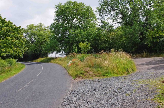
Pigstyehill Coppice is a picturesque woodland located in Worcestershire, a county in the West Midlands region of England. Situated near the village of Hartlebury, this enchanting forest covers an area of approximately 30 acres. The name "Pigstyehill" derives from the area's historical use as a site for keeping pigs.

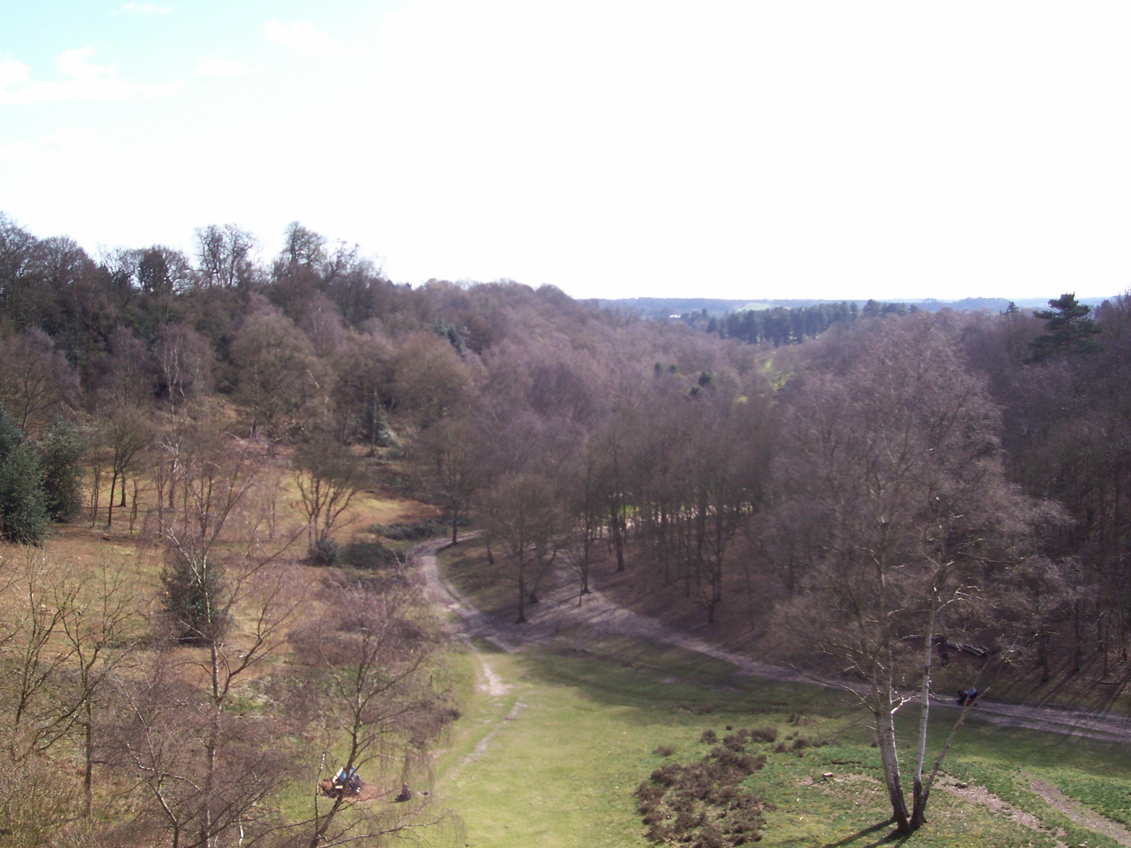
This ancient coppice is characterized by its diverse range of trees and wildlife, making it a haven for nature enthusiasts. The woodland primarily consists of broadleaf trees, including oak, ash, and beech, which create a dense canopy overhead. The forest floor is adorned with a vibrant carpet of wildflowers, adding to its natural beauty.

Pigstyehill Coppice is also home to a variety of wildlife species. Visitors may encounter squirrels, badgers, and foxes, as well as a rich diversity of birdlife, such as woodpeckers, owls, and songbirds. The tranquil atmosphere and abundance of flora and fauna make it an ideal spot for birdwatching and wildlife photography.

The woodland offers several walking trails, allowing visitors to explore its serene surroundings. These paths meander through the forest, offering glimpses of babbling brooks and quaint bridges along the way. The coppice is maintained by local conservation groups, ensuring the preservation of its natural habitat and promoting sustainable forestry practices.

Pigstyehill Coppice is a popular destination for both locals and tourists seeking a peaceful retreat in nature. Its idyllic setting, combined with its rich biodiversity, makes it a must-visit location for anyone looking to immerse themselves in the beauty of Worcestershire's woodlands.

If you have any feedback on the listing, please let us know in the comments section below.

Pigstyehill Coppice Images

Images are sourced within 2km of 52.399636/-2.2952697 or Grid Reference SO8077. Thanks to Geograph Open Source API. All images are credited.

Layby and road near Trimpley This minor road comes up from the Severn Trent water treatment plant by the River Severn, and Eymore Wood, and passes through the small village of Trimpley. On the verge between the road and the layby, some poppies have very recently appeared.

<a href="https://www.geograph.org.uk/photo/2531606">SO7878 : Poppies in the roadside verge near Trimpley</a>.
Layby and road near Trimpley
This minor road comes up from the Severn Trent water treatment plant by the River Severn, and Eymore Wood, and passes through the small village of Trimpley. On the verge between the road and the layby, some poppies have very recently appeared. SO7878 : Poppies in the roadside verge near Trimpley.
Poppies in the roadside verge near Trimpley In the last couple of weeks, a few poppies have emerged here. It is surprising because the impressive displays, a few miles away, in fields near Bewdley, which appeared in early June, have almost completely disappeared.

<a href="https://www.geograph.org.uk/photo/2531580">SO7878 : Layby and road near Trimpley</a>.
Poppies in the roadside verge near Trimpley
In the last couple of weeks, a few poppies have emerged here. It is surprising because the impressive displays, a few miles away, in fields near Bewdley, which appeared in early June, have almost completely disappeared. SO7878 : Layby and road near Trimpley.
Habberley Road
Habberley Road
Distorted silver birch Growing alongside a path through Pigstyehill Coppice, in Habberley Valley.
Distorted silver birch
Growing alongside a path through Pigstyehill Coppice, in Habberley Valley.
Trimpley Lane, Wribbenhall, Bewdley The start of Trimpley Lane photographed from its junction with Habberley Road. The part of Bewdley on the east side of the River Severn is usually known as Wribbenhall. This particular part is or was known as Catchems End, although that name seems to be falling into disuse. On the left is a warning sign against using Trimpley Lane as a route into Bewdley's town centre. However, anyone ignoring this would still have to rejoin the main road to cross the River Severn by Bewdley Bridge.
Trimpley Lane, Wribbenhall, Bewdley
The start of Trimpley Lane photographed from its junction with Habberley Road. The part of Bewdley on the east side of the River Severn is usually known as Wribbenhall. This particular part is or was known as Catchems End, although that name seems to be falling into disuse. On the left is a warning sign against using Trimpley Lane as a route into Bewdley's town centre. However, anyone ignoring this would still have to rejoin the main road to cross the River Severn by Bewdley Bridge.
New Road, Wribbenhall, Bewdley New Road is a mixture of old and new housing. It runs between Habberley Road and Kidderminster Road. There is no access for motor vehicles from Habberley Road, as bollards have been placed across New Road, just behind the camera position in this photograph.
New Road, Wribbenhall, Bewdley
New Road is a mixture of old and new housing. It runs between Habberley Road and Kidderminster Road. There is no access for motor vehicles from Habberley Road, as bollards have been placed across New Road, just behind the camera position in this photograph.
Habberley Road (B4190), Wribbenhall, Bewdley Habberley Road is part of the B4190 road which goes to the outskirts of Kidderminster, and then on to the village of Wolverley.
Habberley Road (B4190), Wribbenhall, Bewdley
Habberley Road is part of the B4190 road which goes to the outskirts of Kidderminster, and then on to the village of Wolverley.
House near Trimpley
House near Trimpley
Trees and pasture near Holbeache
House near Holbeache
View east from Wassell Wood Looking through a gap in the trees on the eastern edge of a medieval earthworks.
View east from Wassell Wood
Looking through a gap in the trees on the eastern edge of a medieval earthworks.
The village pond at Trimpley (1), Worcs The small village of Trimpley still retains a village pond.

<a href="https://www.geograph.org.uk/photo/3909856">SO7978 : The village pond at Trimpley (2), Worcs</a>.
The village pond at Trimpley (1), Worcs
The small village of Trimpley still retains a village pond. SO7978 : The village pond at Trimpley (2), Worcs.
The village pond at Trimpley (2), Worcs The attractive village pond in the small village of Trimpley.

<a href="https://www.geograph.org.uk/photo/3909840">SO7978 : The village pond at Trimpley (1), Worcs</a>.
The village pond at Trimpley (2), Worcs
The attractive village pond in the small village of Trimpley. SO7978 : The village pond at Trimpley (1), Worcs.
Looking towards a road junction at Trimpley, Worcs The minor road in the foreground has come from Severn Trent Water's Trimpley Reservoir and has just passed through the main part of the small village of Trimpley. Ahead it forms a junction with a minor road running between Shatterford and Bewdley.
Looking towards a road junction at Trimpley, Worcs
The minor road in the foreground has come from Severn Trent Water's Trimpley Reservoir and has just passed through the main part of the small village of Trimpley. Ahead it forms a junction with a minor road running between Shatterford and Bewdley.
Road through the village of Trimpley, Worcs This road goes through the main part of the small village of Trimpley. On the right is part of the village pond overlooked by a wooden bench seat. Further along the road, but not visible in this view, is the short access road to the local church and a small lane leading to the village hall. After leaving the village the road continues to Eymore Wood and then becomes a private access road to Severn Trent Water's Trimpley Reservoir and works.

<a href="https://www.geograph.org.uk/photo/3909840">SO7978 : The village pond at Trimpley (1), Worcs</a>.
Road through the village of Trimpley, Worcs
This road goes through the main part of the small village of Trimpley. On the right is part of the village pond overlooked by a wooden bench seat. Further along the road, but not visible in this view, is the short access road to the local church and a small lane leading to the village hall. After leaving the village the road continues to Eymore Wood and then becomes a private access road to Severn Trent Water's Trimpley Reservoir and works. SO7978 : The village pond at Trimpley (1), Worcs.
Seat by the village pond, Trimpley, Worcs This bench seat overlooks the adjacent village pond.

<a href="https://www.geograph.org.uk/photo/3909840">SO7978 : The village pond at Trimpley (1), Worcs</a>.
Seat by the village pond, Trimpley, Worcs
This bench seat overlooks the adjacent village pond. SO7978 : The village pond at Trimpley (1), Worcs.
Entrance to Palton Alpacas, Trimpley, Worcs Palton Alpacas have a herd of alpacas at Trimpley.

<a href="https://www.geograph.org.uk/photo/3909988">SO7878 : Alpacas at Trimpley, Worcs</a>.
Entrance to Palton Alpacas, Trimpley, Worcs
Palton Alpacas have a herd of alpacas at Trimpley. SO7878 : Alpacas at Trimpley, Worcs.
Alpacas at Trimpley, Worcs Alpacas look like smaller versions of llamas. They have been domesticated for thousands of years and originated in South America. They are prized for the quality of their coats which have been used for a wide range of products. Several different colours can be seen here. 

Photographed from the adjacent public road. There are no public rights of way over this privately owned field.

<a href="https://www.geograph.org.uk/photo/3909976">SO7878 : Entrance to Palton Alpacas, Trimpley, Worcs</a>.
Alpacas at Trimpley, Worcs
Alpacas look like smaller versions of llamas. They have been domesticated for thousands of years and originated in South America. They are prized for the quality of their coats which have been used for a wide range of products. Several different colours can be seen here. Photographed from the adjacent public road. There are no public rights of way over this privately owned field. SO7878 : Entrance to Palton Alpacas, Trimpley, Worcs.
Show me another place!

Pigstyehill Coppice is located at Grid Ref: SO8077 (Lat: 52.399636, Lng: -2.2952697)

Administrative County: Worcestershire

District: Wyre Forest

Police Authority: West Mercia

What 3 Words

///headsets.harmonica.stuffing. Near Bewdley, Worcestershire

Related Wikis

Trimpley

Trimpley (grid reference SO793784) is a hamlet in the parish of Kidderminster Foreign. It lies on the ridge of Shatterford Hill, north of Wribbenhall...

Habberley, Worcestershire

Habberley was one of the hamlets of the ancient parish of Kidderminster in the county of Worcestershire, England. It is now divided so that part of it...

Drakelow, Worcestershire

Drakelow is a hamlet in Worcestershire, England. It is one of the ancient townships of the manor of Wolverley, whose extent was similar to that of the...

Franche, Worcestershire

Franche is a village in Worcestershire, England, just outside Kidderminster. It is served by two main bus services. These are service 297 operated by...

Baxter College

Baxter College is a mixed secondary school with academy status located in Kidderminster, Worcestershire, England. Prior to September 2002 the school was...

Northwood Halt railway station

Northwood Halt is an unstaffed request stop on the Severn Valley Railway in Worcestershire, situated a little to the north of Bewdley on the outskirts...

Dowles Brook

Dowles Brook flows through the heart of the Wyre Forest, into the former civil parish of Dowles and into the River Severn. == History == In 1902, ornithologist...

West Midland Safari Park

West Midland Safari and Leisure Park is a safari park located in Bewdley in Worcestershire, England. It was opened under the name of West Midland Safari...

Nearby Amenities

Located within 500m of 52.399636,-2.2952697
Habberley Golf Club
Naptan AtcoCode: 2000G022356
Naptan Bearing: NW
Naptan BusStopType: CUS
Naptan CommonName: Habberley Golf Club
Naptan Landmark: Golf Club
Naptan NaptanCode: wocgpdtd
Naptan ShortCommonName: Golf Club
Naptan Street: Habberley Lane
Naptan Verified: no
Source: naptan_import
Lat/Long: 52.4017152/-2.2905591
Low Habberley Farm
Naptan AtcoCode: 2000G500145
Naptan Bearing: N
Naptan BusStopType: CUS
Naptan CommonName: Low Habberley Farm
Naptan Crossing: Valley Close
Naptan Indicator: Opp
Naptan Landmark: Low Habberley Farm
Naptan NaptanCode: wocdpadg
Naptan PlusbusZoneRef: KDRMNST
Naptan Street: Habberley Lane
Naptan Verified: no
Source: naptan_import
Lat/Long: 52.3988352/-2.2881298
Bench
Lat/Long: 52.3963042/-2.2907441
Bench
Lat/Long: 52.397101/-2.2912461
Barrier: kissing_gate
Foot: yes
Lat/Long: 52.3992792/-2.2983922
Barrier: kissing_gate
Foot: yes
Lat/Long: 52.3997897/-2.300393
Parking
Fee: no
Note: summer and/or impaired mobility only
Lat/Long: 52.3981376/-2.2917595
Bench
Backrest: no
Colour: brown
Material: wood
Operator: Habberley Valley Tea Rooms
Seats: 8
Lat/Long: 52.3981137/-2.2915537
Bench
Backrest: no
Colour: brown
Material: wood
Operator: Habberley Valley Tea Rooms
Seats: 8
Lat/Long: 52.3980881/-2.2915528
Board Type: wildlife
Information: board
Tourism: information
Lat/Long: 52.3970208/-2.2913461
The data included in this document is from www.openstreetmap.org. The data is made available under ODbL.

Have you been to Pigstyehill Coppice?

Leave your review of Pigstyehill Coppice below (or comments, questions and feedback).