Countess Wood

Wood, Forest in Northumberland

England

Countess Wood

A68 beside Catcleugh Reservoir Towards Jedburgh.
A68 beside Catcleugh Reservoir Credit: JThomas

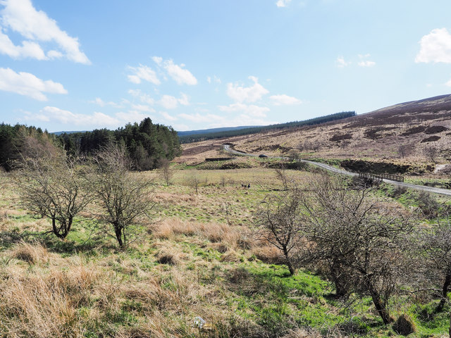
Countess Wood is a beautiful forest located in the county of Northumberland, England. Situated near the village of Wood, this woodland area covers approximately 100 acres of land. The forest is known for its diverse range of trees, including oak, ash, beech, and birch, which create a dense and enchanting canopy.

The woodland is home to various wildlife species, making it a haven for nature enthusiasts and wildlife photographers. Visitors can spot a wide array of birds, such as owls, woodpeckers, and thrushes, as well as mammals like deer, foxes, and squirrels. Countess Wood offers a serene and peaceful environment, ideal for those seeking a quiet retreat from the hustle and bustle of city life.

The forest features several walking trails that allow visitors to explore its natural beauty. These trails vary in length and difficulty, catering to both casual walkers and avid hikers. Along the way, visitors can enjoy stunning views of the surrounding countryside and may even stumble upon hidden streams and ponds.

Countess Wood also has a picnic area, providing a perfect spot for families and friends to gather and enjoy a meal surrounded by nature. The peaceful atmosphere and abundant wildlife make it an ideal location for birdwatching, photography, and simply reconnecting with the natural world.

Overall, Countess Wood in Northumberland offers a captivating experience for nature lovers, providing a tranquil escape into the heart of the English countryside.

If you have any feedback on the listing, please let us know in the comments section below.

Countess Wood Images

Images are sourced within 2km of 55.31944/-2.4354359 or Grid Reference NT7202. Thanks to Geograph Open Source API. All images are credited.

A68 beside Catcleugh Reservoir Towards Jedburgh.
A68 beside Catcleugh Reservoir
Towards Jedburgh.
A68 towards Jedburgh
Hillside grazing near Ramshope Farm
A68 beside Catcleugh reservoir Towards Carter Bar.
A68 beside Catcleugh reservoir
Towards Carter Bar.
Catcleugh Reservoir from the air The reservoir is at the bottom of the photo.
Catcleugh Reservoir from the air
The reservoir is at the bottom of the photo.
Lumsdon Law from the air The 475m Lumsdon Law is at the bottom of the photo, to the left of Catcleugh Reservoir.
Lumsdon Law from the air
The 475m Lumsdon Law is at the bottom of the photo, to the left of Catcleugh Reservoir.
Farm track rising from gate The track climbs from the A68 as it passes along the north side of Catcleugh Reservoir.
Farm track rising from gate
The track climbs from the A68 as it passes along the north side of Catcleugh Reservoir.
Moorland in upper Redesdale The River Rede flows through the area in view soon to enter Catcleugh Reservoir which is among the trees to the left of the image. A sign at the start of the hill road where it leaves the A68 tells that the Whitelee Reserve of the Northumberland Wildlife Trust lies ahead.
Moorland in upper Redesdale
The River Rede flows through the area in view soon to enter Catcleugh Reservoir which is among the trees to the left of the image. A sign at the start of the hill road where it leaves the A68 tells that the Whitelee Reserve of the Northumberland Wildlife Trust lies ahead.
Catcleugh Reservoir Catcleugh Reservoir is in Northumberland, adjacent to the A68 road. It was constructed between 1884 and 1905 for the Newcastle and Gateshead Water Company.
Catcleugh Reservoir
Catcleugh Reservoir is in Northumberland, adjacent to the A68 road. It was constructed between 1884 and 1905 for the Newcastle and Gateshead Water Company.
Trees on the shoreline of Catcleugh Reservoir Catcleugh Reservoir is in Northumberland, adjacent to the A68 road. It was constructed between 1884 and 1905 for the Newcastle and Gateshead Water Company.
Trees on the shoreline of Catcleugh Reservoir
Catcleugh Reservoir is in Northumberland, adjacent to the A68 road. It was constructed between 1884 and 1905 for the Newcastle and Gateshead Water Company.
A68 nears Treshnish Road
A68 crossing Ramshope Burn
Old Milestone by the A68, Catcleugh Reservoir, Rochester Parish Carved stone post by the A68, in parish of ROCHESTER (TYNEDALE District), Catcleugh reservoir; by Boathouse Cottage, 40yds South East of Ramshope Cottage, on grass verge, on North side of road. Newcastle quadrant stone, erected by the Elsdon & Rudwater turnpike trust in the 19th century. 

Inscription reads:-
: Newcastle / 42 / Miles : : Jedbro / 14 / Miles : 

Grade II listed. List Entry Number: 1156348
<span class="nowrap"><a title="https://historicengland.org.uk/listing/the-list/list-entry/1156348" rel="nofollow ugc noopener" href="https://historicengland.org.uk/listing/the-list/list-entry/1156348">Link</a><img style="margin-left:2px;" alt="External link" title="External link - shift click to open in new window" src="https://s1.geograph.org.uk/img/external.png" width="10" height="10"/></span>

Milestone Society National ID: NB_NCJB42.
Old Milestone by the A68, Catcleugh Reservoir, Rochester Parish
Carved stone post by the A68, in parish of ROCHESTER (TYNEDALE District), Catcleugh reservoir; by Boathouse Cottage, 40yds South East of Ramshope Cottage, on grass verge, on North side of road. Newcastle quadrant stone, erected by the Elsdon & Rudwater turnpike trust in the 19th century. Inscription reads:- : Newcastle / 42 / Miles : : Jedbro / 14 / Miles : Grade II listed. List Entry Number: 1156348 LinkExternal link Milestone Society National ID: NB_NCJB42.
Chattlehope "The Chattlehope we see today, sitting in ivy-trimmed isolation on the shore of Catcleugh Reservoir, dates from 1901. An engraved date-stone on its frontage proves it. But parts of the house are much older, and have moved in space as well as time.

The original Chattlehope Farm was built when Queen Anne, not Queen Victoria, ruled, but its original site is now under fathoms of water. Old fashioned features – such as the triangular 'eyebrow' pediments above the three front windows – were probably among the stone salvaged when Chattlehope had to be moved out of the way of the Catcleugh Reservoir.

In 1899, it was agreed that desperate measures were needed to improve the water supply for sprawling Tyneside. A new reservoir was needed, and the Chattlehope valley in Redesdale was chosen for sacrifice."

'Breeding ground of a terrier', Hexham Courant, 30th November 2009

The date stone above the door records the rebuild in 1901, while within the pediment are inscribed stones with the initials G.H. and E.F. which came from the older house. They refer to Gabriel Hall, High Sheriff of Northumberland in 1706, and his wife, who owned Chattlehope as part of their huge Redesdale Estates.
Elsdon Lairds by J. C. Hodgson in History of the Bewickshire Naturalists' Club (1914)
Chattlehope
"The Chattlehope we see today, sitting in ivy-trimmed isolation on the shore of Catcleugh Reservoir, dates from 1901. An engraved date-stone on its frontage proves it. But parts of the house are much older, and have moved in space as well as time. The original Chattlehope Farm was built when Queen Anne, not Queen Victoria, ruled, but its original site is now under fathoms of water. Old fashioned features – such as the triangular 'eyebrow' pediments above the three front windows – were probably among the stone salvaged when Chattlehope had to be moved out of the way of the Catcleugh Reservoir. In 1899, it was agreed that desperate measures were needed to improve the water supply for sprawling Tyneside. A new reservoir was needed, and the Chattlehope valley in Redesdale was chosen for sacrifice." 'Breeding ground of a terrier', Hexham Courant, 30th November 2009 The date stone above the door records the rebuild in 1901, while within the pediment are inscribed stones with the initials G.H. and E.F. which came from the older house. They refer to Gabriel Hall, High Sheriff of Northumberland in 1706, and his wife, who owned Chattlehope as part of their huge Redesdale Estates. Elsdon Lairds by J. C. Hodgson in History of the Bewickshire Naturalists' Club (1914)
Track east of Chattlehope On the left, beyond the barns, is the newest, modern Chattlehope farmhouse. The house rebuilt in 1901 <a href="https://www.geograph.org.uk/photo/6062482">NT7302 : Chattlehope</a> is in line with the track.
Track east of Chattlehope
On the left, beyond the barns, is the newest, modern Chattlehope farmhouse. The house rebuilt in 1901 NT7302 : Chattlehope is in line with the track.
Pasture south of Catcleugh Reservoir
Chattlehope above Catcleugh Reservoir For description see <a href="https://www.geograph.org.uk/photo/6062482">NT7302 : Chattlehope</a>
Chattlehope above Catcleugh Reservoir
For description see NT7302 : Chattlehope
Old Milestone by the A68, near Ramshope Lodge Carved stone post by the A68, in parish of ROCHESTER (TYNEDALE District), 100m Southeast of Ramshope Lodge, on grass verge, on North side of road. Newcastle quadrant stone, erected by the Elsdon & Rudwater turnpike trust in the 19th century. 

Inscription reads:-
: Newcastle / 43 / Miles : : Jedbro / 13 / Miles :

Grade II listed.  
List Entry Number: 1044871 <span class="nowrap"><a title="https://historicengland.org.uk/listing/the-list/list-entry/1044871" rel="nofollow ugc noopener" href="https://historicengland.org.uk/listing/the-list/list-entry/1044871">Link</a><img style="margin-left:2px;" alt="External link" title="External link - shift click to open in new window" src="https://s1.geograph.org.uk/img/external.png" width="10" height="10"/></span>

Milestone Society National ID: NB_NCJB43.
Old Milestone by the A68, near Ramshope Lodge
Carved stone post by the A68, in parish of ROCHESTER (TYNEDALE District), 100m Southeast of Ramshope Lodge, on grass verge, on North side of road. Newcastle quadrant stone, erected by the Elsdon & Rudwater turnpike trust in the 19th century. Inscription reads:- : Newcastle / 43 / Miles : : Jedbro / 13 / Miles : Grade II listed. List Entry Number: 1044871 LinkExternal link Milestone Society National ID: NB_NCJB43.
Show me another place!

Countess Wood is located at Grid Ref: NT7202 (Lat: 55.31944, Lng: -2.4354359)

Unitary Authority: Northumberland

Police Authority: Northumbria

What 3 Words

///goodnight.pines.polishing. Near Rochester, Northumberland

Nearby Locations

Countess Wood

Related Wikis

Ramshope

Ramshope is a hamlet and former civil parish, now in the parish of Rochester in Northumberland, England located in Northumberland National Park. It lies...

Whitelee Moor

Whitelee Moor is nature reserve of the Northumberland Wildlife Trust, in Northumberland, England, near Carter Bar. A large part of the moor is blanket...

Byrness

Byrness is a village within Rochester civil parish in Northumberland, England. It is approximately 37 miles (60 km) north-west of Newcastle upon Tyne on...

Carter Bar

Carter Bar is a pass in the Cheviot Hills, on the Anglo-Scottish border. It lies east of Carter Fell at the head of Redesdale, and is crossed by the A68...

Have you been to Countess Wood?

Leave your review of Countess Wood below (or comments, questions and feedback).