Coppingford

Settlement in Huntingdonshire Huntingdonshire

England

Coppingford

A1(M) southbound, climbing Stangate Hill towards Alconbury The junction ahead marks the point where the Old North Road, via Huntingdon, Royston and Ware, diverged from the Great North Road that took a more westerly course.
A1(M) southbound, climbing Stangate Hill towards Alconbury Credit: Christopher Hilton

Coppingford is a small village located in the district of Huntingdonshire, Cambridgeshire, England. Situated approximately 8 miles northwest of Huntingdon, Coppingford is a rural community with a population of around 150 residents.

The village is known for its picturesque setting, surrounded by rolling countryside and farmland. It features a charming mix of traditional cottages and modern houses, giving it a unique character. The local landscape offers stunning views and ample opportunities for walking, cycling, and outdoor activities.

Coppingford benefits from its proximity to nearby towns and villages, providing residents with access to essential amenities. The village itself does not have any shops, schools, or pubs, but these can be found within a short distance in neighboring communities.

Despite its small size, Coppingford has a strong sense of community spirit. Regular events and activities are organized by local groups and organizations, fostering a close-knit and friendly atmosphere.

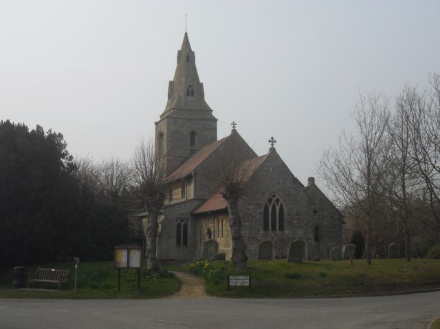
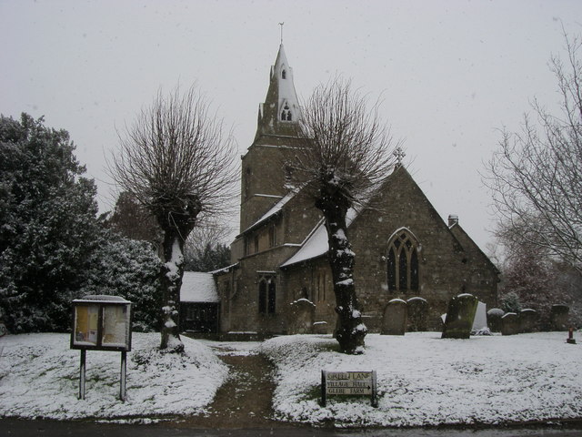
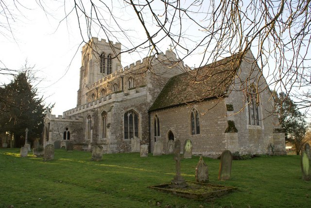
Historically, the village was mentioned in the Domesday Book in 1086, and remnants of its past can still be found, including a 12th-century church, St. Thomas à Becket, which stands as a testament to the village's rich history.

Overall, Coppingford is a tranquil and idyllic village, offering residents and visitors alike a peaceful retreat in the heart of the English countryside.

If you have any feedback on the listing, please let us know in the comments section below.

Coppingford Images

Images are sourced within 2km of 52.405831/-0.28752 or Grid Reference TL1680. Thanks to Geograph Open Source API. All images are credited.

A1(M) southbound, climbing Stangate Hill towards Alconbury The junction ahead marks the point where the Old North Road, via Huntingdon, Royston and Ware, diverged from the Great North Road that took a more westerly course.
A1(M) southbound, climbing Stangate Hill towards Alconbury
The junction ahead marks the point where the Old North Road, via Huntingdon, Royston and Ware, diverged from the Great North Road that took a more westerly course.
Looking towards the Old Quarter The Old Quarter is an area of woodland.
Looking towards the Old Quarter
The Old Quarter is an area of woodland.
A1(M) - gantries on Stangate Hill No messages today - traffic is flowing smoothly. In the opposite direction signs are displayed for the A1 - A14 junction.
A1(M) - gantries on Stangate Hill
No messages today - traffic is flowing smoothly. In the opposite direction signs are displayed for the A1 - A14 junction.
A1(M), Stangate Hill The A1 is the longest numbered road in the UK at 410 miles long. It connects London with Edinburgh, via the east of England. 
For much of its path it follows the Great North Road the old coaching route between London and Edinburgh. Several sections of the route are classified as motorway A1(M). The modern A1 bypasses the towns the Great North Road passed through and is dual carriageway for most of its route through England.
A1(M), Stangate Hill
The A1 is the longest numbered road in the UK at 410 miles long. It connects London with Edinburgh, via the east of England. For much of its path it follows the Great North Road the old coaching route between London and Edinburgh. Several sections of the route are classified as motorway A1(M). The modern A1 bypasses the towns the Great North Road passed through and is dual carriageway for most of its route through England.
St Margaret, Upton
St Margaret, Upton
St Margaret, Upton Interesting to note the tower is rectangular shaped with West/East wider than the other 2 sides, another example of this can be seen at Peterborough Cathedral's bell tower <a href="https://www.geograph.org.uk/photo/3197251">TL1998 : Cathedral Bell Tower</a>.
St Margaret, Upton
Interesting to note the tower is rectangular shaped with West/East wider than the other 2 sides, another example of this can be seen at Peterborough Cathedral's bell tower TL1998 : Cathedral Bell Tower.
St Margaret, Upton Interior facing the Chancel.
St Margaret, Upton
Interior facing the Chancel.
A1(M) near Coppingford The road continues to run straight, almost north.
A1(M) near Coppingford
The road continues to run straight, almost north.
A1(M) at Stargate Hill
Shining straw bales
Shining straw bales
Gantry, A1(M) The A1 is the longest numbered road in the UK at 410 miles long. It connects London with Edinburgh, via the east of England. 
For much of its path it follows the Great North Road the old coaching route between London and Edinburgh. Several sections of the route are classified as motorway A1(M). The modern A1 bypasses the towns the Great North Road passed through and is dual carriageway for most of its route through England.
Gantry, A1(M)
The A1 is the longest numbered road in the UK at 410 miles long. It connects London with Edinburgh, via the east of England. For much of its path it follows the Great North Road the old coaching route between London and Edinburgh. Several sections of the route are classified as motorway A1(M). The modern A1 bypasses the towns the Great North Road passed through and is dual carriageway for most of its route through England.
Road nearing Holly Lodge Road from Brook Lodge nearing Holly Lodge
Road nearing Holly Lodge
Road from Brook Lodge nearing Holly Lodge
Junction with the Hamerton to Alconbury Weston Road Road from Holly Lodge junction with the Hamerton to Alconbury Weston Road
Junction with the Hamerton to Alconbury Weston Road
Road from Holly Lodge junction with the Hamerton to Alconbury Weston Road
Path to Salome Farm Off the road to Hamerton the path to Salome Farm
Path to Salome Farm
Off the road to Hamerton the path to Salome Farm
St Margaret's Church St Margaret's Church Upton
St Margaret's Church
St Margaret's Church Upton
Ordnance Survey Benchmark - Coppingford, Mile Brook Bridge Ordnance Survey Benchmark (OSBM) used for levelling height above Ordnance Datum (OD).
Height: 25.1186m OD (Newlyn). Mark verified by the Ordnance Survey in 1966. Description: BR N PARA W ANG SW FACE. 0.4m above ground. 3rd Order BM.

Context: <a href="https://www.geograph.org.uk/photo/4798556">TL1579 : Ordnance Survey Benchmark - Coppingford, Mile Brook Bridge</a>
Ordnance Survey Benchmark - Coppingford, Mile Brook Bridge
Ordnance Survey Benchmark (OSBM) used for levelling height above Ordnance Datum (OD). Height: 25.1186m OD (Newlyn). Mark verified by the Ordnance Survey in 1966. Description: BR N PARA W ANG SW FACE. 0.4m above ground. 3rd Order BM. Context: TL1579 : Ordnance Survey Benchmark - Coppingford, Mile Brook Bridge
Ordnance Survey Benchmark - Coppingford, Mile Brook Bridge Ordnance Survey Benchmark (OSBM) used for levelling height above Ordnance Datum (OD).
Height: 25.1186m OD (Newlyn). Mark verified by the Ordnance Survey in 1966. Description: BR N PARA W ANG SW FACE. 0.4m above ground. 3rd Order BM.

Close-up: <a href="https://www.geograph.org.uk/photo/4798555">TL1579 : Ordnance Survey Benchmark - Coppingford, Mile Brook Bridge</a>
Ordnance Survey Benchmark - Coppingford, Mile Brook Bridge
Ordnance Survey Benchmark (OSBM) used for levelling height above Ordnance Datum (OD). Height: 25.1186m OD (Newlyn). Mark verified by the Ordnance Survey in 1966. Description: BR N PARA W ANG SW FACE. 0.4m above ground. 3rd Order BM. Close-up: TL1579 : Ordnance Survey Benchmark - Coppingford, Mile Brook Bridge
Track to Coppingford Lodge Farm A private route.
Track to Coppingford Lodge Farm
A private route.
Show me another place!

Coppingford is located at Grid Ref: TL1680 (Lat: 52.405831, Lng: -0.28752)

Administrative County: Cambridgeshire

District: Huntingdonshire

Police Authority: Cambridgeshire

What 3 Words

///amused.crunched.goodbyes. Near Sawtry, Cambridgeshire

Related Wikis

Coppingford

Coppingford is a village and former civil parish, now in the parish of Upton and Coppingford, in Cambridgeshire, England. Coppingford lies approximately...

Upton, Huntingdonshire

Upton is a village and former civil parish, now in the parish of Upton and Coppingford, in the Huntingdonshire district, in the county of Cambridgeshire...

Aversley Wood

Aversley Wood is a 62.3 hectares (154 acres) biological Site of Special Scientific Interest south-west of Sawtry in Cambridgeshire. It is owned and managed...

Hamerton

Hamerton is a village in and former civil parish, now in the parish of Hamerton and Steeple Gidding, in Cambridgeshire, England. Hamerton lies approximately...

Nearby Amenities

Located within 500m of 52.405831,-0.28752
Created By: Merkaartor 0.12
Lat/Long: 52.4076617/-0.2843784
Created By: Merkaartor 0.12
Lat/Long: 52.4036691/-0.2923714
Coppingford
Created By: Merkaartor 0.12
Place: hamlet
Wikidata: Q2466310
Lat/Long: 52.405744/-0.2879082
Power: pole
Lat/Long: 52.4103026/-0.2882139
Power: pole
Lat/Long: 52.4094003/-0.2908949
Power: pole
Lat/Long: 52.4088456/-0.2926437
Power: pole
Lat/Long: 52.4098927/-0.2894344
Man Made: tower
Tower Type: communication
Lat/Long: 52.4068929/-0.2806152
The data included in this document is from www.openstreetmap.org. The data is made available under ODbL.

Have you been to Coppingford?

Leave your review of Coppingford below (or comments, questions and feedback).