Copdock

Settlement in Suffolk Babergh

England

Copdock

Pasture gate by Coles Green Farm
Pasture gate by Coles Green Farm Credit: Evelyn Simak

Copdock is a small village located in the county of Suffolk, England. Situated approximately four miles south of Ipswich, it lies within the district of Babergh. The village is positioned along the A12, a major road that connects London to the coastal towns of Lowestoft and Great Yarmouth.

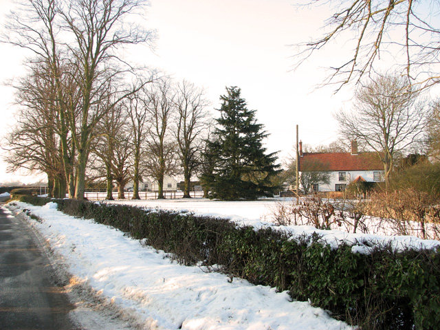
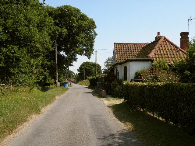
With a population of around 1,000 residents, Copdock offers a peaceful and rural environment surrounded by picturesque countryside. The village is characterized by its charming cottages, historic buildings, and traditional English village atmosphere.

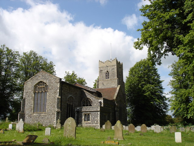
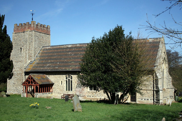
One of the notable landmarks in Copdock is the St. Peter's Church, a beautiful medieval church that dates back to the 14th century. The church features stunning architectural details and houses several interesting historical artifacts.

Copdock also boasts a range of amenities and services for its residents. These include a primary school, a village hall, a post office, a convenience store, and a pub. The village pub, named The Red Lion, is a popular gathering spot for locals and visitors alike, offering a warm and friendly atmosphere along with delicious food and drinks.

The surrounding countryside provides ample opportunities for outdoor activities such as walking, cycling, and horse riding. Additionally, the nearby Orwell River offers scenic views and is a popular spot for boating and fishing enthusiasts.

In summary, Copdock is a charming village in Suffolk, offering a peaceful and rural lifestyle along with a range of amenities and access to beautiful countryside.

If you have any feedback on the listing, please let us know in the comments section below.

Copdock Images

Images are sourced within 2km of 52.030707/1.082465 or Grid Reference TM1141. Thanks to Geograph Open Source API. All images are credited.

Pasture gate by Coles Green Farm
Keeping fit Jogger on country road east of Chattisham.
Keeping fit
Jogger on country road east of Chattisham.
Electricity transformer by Coles Green Farm
Snowy field by Coles Green Farm
Snowy scenery east of Chattisham
Coles Green Farmhouse in the snow
Wenham Road & Folly Lane Byway Near Cottage Farm
Wenham Road & Folly Lane Byway
Near Cottage Farm
Folly Lane Byway off Wenham Road Near Cottage Farm
Folly Lane Byway off Wenham Road
Near Cottage Farm
Wenham Road & The Barn Veterinary Practice <span class="nowrap"><a title="http://www.barnvets.com/" rel="nofollow ugc noopener" href="http://www.barnvets.com/">Link</a><img style="margin-left:2px;" alt="External link" title="External link - shift click to open in new window" src="https://s1.geograph.org.uk/img/external.png" width="10" height="10"/></span>
Wenham Road & The Barn Veterinary Practice
The Barn Veterinary Practice sign On Wenham Road
<span class="nowrap"><a title="http://www.barnvets.com/" rel="nofollow ugc noopener" href="http://www.barnvets.com/">Link</a><img style="margin-left:2px;" alt="External link" title="External link - shift click to open in new window" src="https://s1.geograph.org.uk/img/external.png" width="10" height="10"/></span>
The Barn Veterinary Practice sign
On Wenham Road LinkExternal link
Chattisham Road near Cole's Green Farm
Folly Lane, looking southeast
Cottage Farm The road in the picture is Wenham Road.
Cottage Farm
The road in the picture is Wenham Road.
Farmhouse at Coles Green Farm
Green Tree Yellow Field Green tree with a yellow field of rape near to Cattisham, Suffolk.
Green Tree Yellow Field
Green tree with a yellow field of rape near to Cattisham, Suffolk.
A14 eastbound at junction 55 for Ipswich
Leaving the A14 westbound at junction 55
Show me another place!

Copdock is located at Grid Ref: TM1141 (Lat: 52.030707, Lng: 1.082465)

Administrative County: Suffolk

District: Babergh

Police Authority: Suffolk

What 3 Words

///reinstate.opposite.levels. Near Capel St Mary, Suffolk

Nearby Locations

Copdock

Related Wikis

Copdock

Copdock is a village and former civil parish, now in the parish of Copdock and Washbrook, in the Babergh district, in the county of Suffolk, England. In...

Old London Road

Old London Road is a cricket ground in Copdock, Suffolk. The first recorded match on the ground was in 1847, when the Gentlemen of Suffolk played the...

Washbrook

Washbrook is a village and former civil parish 3 miles (4.8 km) south west of Ipswich, now in the parish of Copdock and Washbrook, in the Babergh district...

Copdock and Washbrook

Copdock and Washbrook is a civil parish in the Babergh district in the county of Suffolk, England. It covers the villages of Copdock and Washbrook, as...

Nearby Amenities

Located within 500m of 52.030707,1.082465
Copdock
Place: village
Wikidata: Q2879731
Wikipedia: en:Copdock
Lat/Long: 52.0305814/1.0813834
Bus Stop
Fen View
Local Ref: adj
Naptan AtcoCode: 390010543
Naptan Bearing: NE
Naptan CommonName: Fen View
Naptan Landmark: Fen View
Naptan NaptanCode: sufagpam
Naptan PlusbusZoneRef: IPSWICH
Naptan Street: Back Lane
Naptan Verified: no
Source: naptan_import
Lat/Long: 52.0338544/1.0786607
Fen View
Local Ref: opp
Naptan AtcoCode: 390010544
Naptan Bearing: SW
Naptan BusStopType: CUS
Naptan CommonName: Fen View
Naptan Landmark: Fen View
Naptan NaptanCode: sufagpap
Naptan PlusbusZoneRef: IPSWICH
Naptan Street: Back Lane
Naptan Verified: no
Source: naptan_import
Lat/Long: 52.0338524/1.0788081
Hotel
Local Ref: adj
Naptan AtcoCode: 390010578
Naptan Bearing: NE
Naptan BusStopType: CUS
Naptan CommonName: Hotel
Naptan Landmark: Hotel
Naptan NaptanCode: sufagptj
Naptan Street: London Road
Naptan Verified: no
Public Transport: platform
Source: naptan_import
Lat/Long: 52.0280146/1.0798649
Bus Stop
Elm Lane
Local Ref: adj
Naptan AtcoCode: 390010579
Naptan Bearing: NE
Naptan CommonName: Elm Lane
Naptan Landmark: Elm Lane
Naptan NaptanCode: sufagptm
Naptan Street: London Road
Naptan Verified: no
Public Transport: platform
Shelter: yes
Source: naptan_import
Lat/Long: 52.0309627/1.0823401
Bus Stop
Elm Lane
Local Ref: opp
Naptan AtcoCode: 390010580
Naptan Bearing: S
Naptan CommonName: Elm Lane
Naptan Landmark: Elm Lane
Naptan NaptanCode: sufagptp
Naptan Street: London Road
Naptan Verified: no
Public Transport: platform
Source: naptan_import
Lat/Long: 52.0304623/1.0824859
Power: pole
Lat/Long: 52.0293949/1.0868742
Power: pole
Lat/Long: 52.0287932/1.088419
Power: pole
Lat/Long: 52.0298874/1.0856559
Power: pole
Lat/Long: 52.030728/1.0845667
Barrier: stile
Stile: stepover
Lat/Long: 52.0318735/1.089113
Suffolk Suite
Entrance: yes
Lat/Long: 52.0288754/1.0791296
Give Way
Lat/Long: 52.0286159/1.080038
Entrance: main
Lat/Long: 52.031567/1.0893905
Give Way
Direction: forward
Lat/Long: 52.0311684/1.0826961
Give Way
Direction: forward
Lat/Long: 52.0308629/1.0823411
Give Way
Direction: forward
Lat/Long: 52.0307837/1.0822753
Post Box
Operator: Royal Mail
Post Box Mounting: concrete_post
Post Box Type: lamp
Ref: IP8 1365
Royal Cypher: EIIR
Lat/Long: 52.0340506/1.0787094
Post Box
Operator: Royal Mail
Post Box Mounting: pier
Post Box Type: lamp
Ref: IP8 1025
Royal Cypher: EIIR
Lat/Long: 52.0305506/1.0820326
The data included in this document is from www.openstreetmap.org. The data is made available under ODbL.

Have you been to Copdock?

Leave your review of Copdock below (or comments, questions and feedback).